Topic
On The Great Divide
Forum Posting
A Membership is required to post in the forums. Login or become a member to post in the member forums!
Home › Forums › Campfire › Member Trip Reports › On The Great Divide
- This topic is empty.
-
AuthorPosts
-
Jul 19, 2012 at 10:24 pm #1292168
A weekend near Guanella Pass on or near the Continental Divide. A mixture of single track, cross country and jeep track. Great trip!
(Note: My memory card became corrupted and I lost the second day of photos. :( I placed in some photos from a past trip that took in some of the same sights.)
My favorite type of backpacking is ridge walking. Walking along on rolling terrain where there are views to where I am going and from where I came. Where I can look off either side of a ridge and see the meadows below and mountains and lakes caused by events far in the geological past/
To me, it is the epitome of the backpacking experience. To hike where the mountains continue far into the horizon and seemingly without end.
There are many ridge walks I've enjoyed since I've started backpacking. Franconia Ridge is where I started to learned what it means to hike all day on the backbone of the mountains. And the above tree-line traversing in the Pecos is where I started to fall in love with New Mexico.
But to me THE ridge walk will always be the Continental Divide.
Besides the obvious majesty of the mountains and terrain along the Divide itself, for me it the symbolism and mythos behind the Divide that always seem to capture my imagination. The Divide itself has a hold on the American imagination through its culture, the history, and the land around it.
And it makes for d@mn good hiking, too. ;)
A few years ago, I did a trip along the Continental Divide in an area not far from Grays and Torrey Peaks.
The terrain was rolling with amazing views.
I wanted to return, but perhaps take a different route and explore another portion of the area.
So I looked over the map, researched some info from Summitpost and off I went.
Joining me again on this trip would be my buddy Mark. Judy took off for the weekend leaving him free. Adrianna is still nose deep in her master's program (I think she will at least take some time away from her studies for our wedding. ;) ). Both of us were free.
We drove up to Guanella Pass Rd a bit, took a side road up Geneva Creek and parked the vehicle.
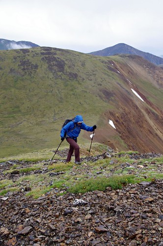
We initially hiked up the popular Shelf Lake trail but quickly left it to attain a sub-ridge off the Divide.

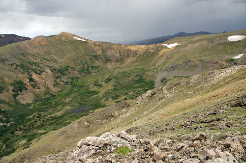
The high point of the ridge gave us a great view of what was ahead.
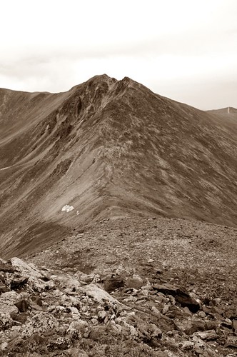
We reached Decatur Mountain and were now on the Continental Divide.
On this overcast day, we could see the popular 14k ft plus Grays and Torreys Peaks.
Though an overcast day, I knew those mountains would be crowded.
By contrast, we had Decatur all to ourselves.
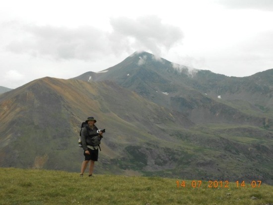
On summit of Decatur. Photo courtesy of Mark Thomas
The summit area was left and we continued our walk along the ridge.
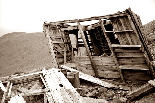
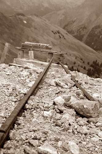
An old mining operation was hiked to just below the summit of Revenue Mountain.
The mining days are long gone.
The current inhabitants of this area are decidedly different from the miners of long ago.
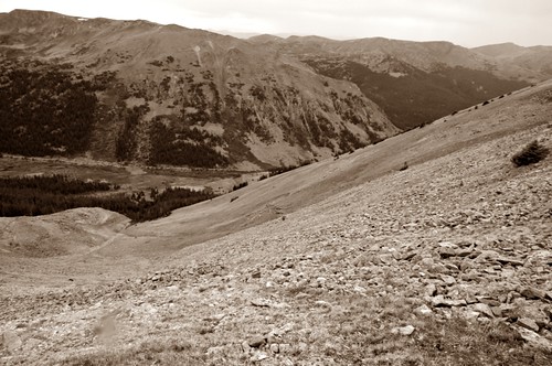
We took a look back to where we had been and could see the ridge extending far into the distance.
Mark and I continued on our ridge walk. to Silver Mountain and up to Santa Fe Peak.
A jeep track was briefly joined near the summit of Santa Fe Peak. We were now on the 'official' Continental Divide Trail but there was no trail to be found. Just the obvious ridge to follow along the Divide itself.
At the saddle between Sullivan and Geneva, we decided to head down to the valley. The weather was starting to turn, the day was growing late and our water was low. Time to make camp, rest up and reflect on what a great day was had.
We hiked up the jeep road a bit (after seeing a group of Texans shoot out their jeep while driving. Seriously.), went off-trail (road?) to just below treeline with a great view of Webster Pass and our hike for tomorrow.
The camp was made, dinner consumed and I almost immediately made up for my sleep deficit with a great night's slumber.
The following morning we woke up to sunshine and a classic Colorado alpine day. We again hiked off-trail (road, really) and made the Webster Pass Summit with it's wonderful views to the valleys below and the mountains above.
Looking down to Webster Pass.
We were now on a very well known jeep route, but still has the high country to ourselves.
We left the divide and went to the top of Red Cone Peak.
Red Cone is the the high point of a well known and beautiful, if a bit hair-raising, jeep route.
Time to leave the high country and our time on the Divide behind.
We walked down the road briefly and walked off-trail along a ridge that would bring us to actual trail for the first time since the Shelf Lake Trail the day before.
View of the ridge we would come down.
The trail was reached after a long descent out of the tundra and into the trees.
We made our walk back to the car (after me not paying attention and walking right by our trail turn..doh! :) ) after some last bit of jeep road walking
Threw on a favorite t-shirt, grabbed a camp chair and enjoyed a beer fresh from the cooler.
I was content. I was happy. And really did not know where else I wanted to be.
But, isn't that any time spent in the mountains?
All the photos<span style=””> (I saved..sigh)</span>
Trip Details
- The Route – We parked at the South Park Trailhead and walked to the Shelf Lake TH for perhaps a quarter of a mile. At an obvious point, we went up the ridge and followed it along the Divide to Decatur Mountain. From there we made away along Revenue, Silver, Santa Fe and Sullivan Peaks. Dropped down to the valley and up to Webster Pass the following day. From there, left the divide to Red Cone and then off-trail along an obvious ridge to the South Park Trail. There, the trail leads back to Geneva Creek Rd and the trailhead for the South Park Trail (#600).
- Stats – All together, the route was roughly 25 miles and 7000' vert gain. The drop into the valley and up to the pass added some gain. :) Dropping to Lake Josephine off the saddle between Sullivan and Geneva (and back up in the morning) would have been another option, but I had never been to the valley below on the other side from Josephine.
- Map – TI Map #104 – Idaho Sprgs /Georgetown / Loveland This site is also good for more info on the individual peaks you'll cross.
- Directions – From Summitpost: for the Shelf Lake Trail. The South Park Trail is just before the Shelf Lake Trail. You'll see a green wire fence. Park along the road here.
- Post-Hike Grub – Al's Pitts BBQ . Not far the start of Guanella Pass Rd at the 'town' of Grants is a road side BBQ place. $10 buys you a very full sampler platter (cash only. Natch) ) from a very simple stand. Grab your food, go to the campground in back also owned by the same people and park your butt under a gazebo by the creek. Eat your BBQ, fish a beer out of the cooler at this BYOB place and cap your weekend off with inexpensive, plentiful and tasty food. The beer to complement this food? Appropriately enough was Boulevard Beer from one of the Mecca of BBQ: Kansas City. The Unfiltered Wheat Beer is easy drinking on a hot summer day. Forgot your beer? The 'town' of Grants has a very (extremely!) small drive-thru liquor store less than five minutes from Al's in the motel parking lot off SH-285.
Jul 20, 2012 at 11:44 am #1896234Great trip report. I am heading to the same area as your previous Divide Hike next week. I hope I get enough good weather to spend alot of time up on the divide.
Ben
-
AuthorPosts


- You must be logged in to reply to this topic.
Forum Posting
A Membership is required to post in the forums. Login or become a member to post in the member forums!
Our Community Posts are Moderated
Backpacking Light community posts are moderated and here to foster helpful and positive discussions about lightweight backpacking. Please be mindful of our values and boundaries and review our Community Guidelines prior to posting.
Get the Newsletter
Gear Research & Discovery Tools
- Browse our curated Gear Shop
- See the latest Gear Deals and Sales
- Our Recommendations
- Search for Gear on Sale with the Gear Finder
- Used Gear Swap
- Member Gear Reviews and BPL Gear Review Articles
- Browse by Gear Type or Brand.
