Southern Spain: the GR-7 in Andalucía, Murcia, and a bit of Valencia
In April and May of 2012 we (Amy and James) spent five weeks backpacking on the GR-7 in southern Spain.
Photos
Our full annotated photo show is found at SmugMug.
Route

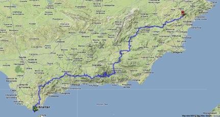

The GR-7 (Gran Recorrido) is a Spanish National Trail extending about 1900 kilometers from Tarifa, located at the Straits of Gibraltar, the southernmost point in continental Spain, northeast to the border with Andorra in the Pyrenees. The southern part of the GR-7 is congruent with the trans-European E-4, which also starts in Tarifa and is currently completed as far as Budapest, Hungary, a distance of around 8000 kilometers. The E-4 is planned to eventually terminate in Greece. We know of one person who has through-hiked the E-4 and we appreciated his very useful blog and trip analysis.
We started our walk at the Tarifa ferry terminal (arriving from a 10 day birding trip in Morocco) and traveled through the Andalucía and Murcia Autonomous Communities and a piece of València Autonomous Community, finishing at the train station in the large town of Elda. Our 34-day walk totaled about 1060 kilometers (658 miles), including various off-route diversions in the Sierra Nevada mountains and a few other places. Total gain was about 23,610 meters (77,460 feet).
Route files
Download our GR7 route in kml format, great for viewing in Google Earth.
Or, if you prefer gpx format, download our GR7 route in gpx format.
Please note that these files show the route that we followed and in places is not congruent with either the book route or the GR-7 gps track available from Rutas y Viajes.
It’s not as good as getting the kml file and viewing in Google Earth, however you can simply view our route on a map using BikeRouteToaster.
The GR-7 in Andalucía has two official variations around the Sierra Nevada; one skirts the northern perimeter of the mountain range and the other follows the southern perimeter. The two variations have similar walking lengths. We chose to walk the southern variation because we believe it had fewer olive groves and more walking on mountain trails. The southern variation also provided us with better access to Mulhacén (3,478 meters, 11,413 feet), the highest peak in continental Spain. Although not directly on the GR-7, we climbed Mulhacén via a diversion starting in Bubión.
We followed the GR-7 using a combination of the guidebook route, the on-the-ground way marks, a downloaded GPX track, and our own variations. We carried detailed satellite images of the entire route in our iPhone and were able to map out opportunities where, by diverting from the established route, we eliminated significant stretches of pavement walking in favor of dirt roads and footpaths. On more than a dozen occasions, we were able to walk variations we believe improves the route. For instance, we by-passed a long stretch of pavement walking along the A-405 leading to Castillo de Castellar by following a slightly longer dirt track west of the established route. Another variation leading to the town of Cieza kept us mostly off pavement and higher in the mountains. After passing through Nigüelas, we walked high in the Sierra Nevada towards Tello before dropping back down to the GR-7 at Lanjeron.
Most of the GR-7 is on unpaved roads with little to no traffic. There are some stretches of pavement walking, mostly when entering and leaving villages and towns. Even then, traffic was usually light to negligible. In a few places, most notably in the Sierra Nevada and other mountains, the GR-7 is on traditional footpaths. Throughout the region we walked, there is an extensive network of dirt roads, varying in quality from graded and maintained to rough farm tracks, but there is not a marked network of public footpaths like those found in England. Many of the dirt roads were undoubtedly centuries-old traditional footpaths that over the years have been widened to accommodate first horse-drawn carts and later vehicles. The tread quality of the footpaths was generally decent.
The dirt roads do go everywhere, crossing fields, through orchards, by farmhouses, and almost all of them are publicly accessible. Vast numbers of “Coto Privado de Caza” signs are posted, but these only mean that while you can’t hunt on the property, walking is permitted. We saw very few “Prohibido el Paso” signs. Although nearly all rural houses were fenced, the fields and countryside fences appeared to be intended to control animals, not to keep people out.
Because the majority of this portion of the GR-7 is on unpaved roads, we thought that it would be a good region for a dirt-road bike trip. There is a well-documented long distance dirt-road bike route in the region called the TransAndalus.
Overall Impressions


The portion of the GR-7 that we walked was generally quite satisfying. While the scenery was not awe-inspiring, it was almost always pleasing. The walking was straightforward, mostly easy, comfortable, and rewarding. The small towns were usually quite beautiful and in harmony with themselves and their surrounding environment. People were friendly and helpful without being in your face all the time. The food was good. There is great peace to the simple routine of a walk like this: get up, eat, walk, eat, walk, locate a place to stay, eat again, sleep and repeat. The terrain and physical environment had enough variety that the walking was rarely boring. As the high point on the southern variation is around 2000 meters, altitude should not be an issue for most people. Anyone who is reasonably fit and has basic backpacking skills and equipment should be able to do this walk.
The GR-7 passes through cultivated lands (primarily olive and almond orchards), grazing areas, native oak forests, tree plantations, cork-oak woodlands, quite arid almost badland regions, and many small towns and villages. The grazed areas range from overgrazed trashed landscapes to attractive hills where the grazing appeared to be done at a sustainable level. The pleasant Mediterranean landscape with flower-filled fields and chaparral often reminded us of our central-California home. Spain has been investing heavily in carbon-free energy sources, and the GR-7 passes commercial photovoltaic installations, numerous wind turbine farms and skirts the perimeter of Andasol, the largest solar power station in the world and Europe’s first parabolic trough solar plant.
The small towns in the first half of the walk were heavily influenced by their Moorish past with compact layouts, narrow winding streets, lots of tile work, and white-painted buildings. They are sometimes referred to as “pueblo blancos” and the words fit. In the later portions of the walk, the villages opened up a bit and tended to be constructed with both more unpainted stone and colorfully painted structures, and have wider, straighter streets. Most towns had one or more large open plazas, often with churches, fountains, and a collection of shops. The churches are almost exclusively Catholic, rather forbidding in appearance and almost always locked up tight. Street signs are small to non-existent, so finding markets, bakeries, and cafes takes paying attention or, more frequently, asking passers-by. There are centuries old buildings, some dating back to Roman times, which are still being used for home, shops and other purposes. There are also many castles, some in ruins and others in reasonable repair, which add a dramatic element to the route.
We have taken one other long walk in Spain; in 2010 we through-walked the Pyrenees High Route (aka HRP) between the Atlantic and Mediterranean along the French/Spanish Border (Trip Report). Compared to the HRP, the GR-7 is much easier, more relaxed, but not nearly as scenic. There is access to shops nearly every day on the GR-7 but not on the HRP. The walking on HRP is primarily on footpath, which is often steep and rocky, so it is more physically demanding than the GR-7. If you have an opportunity to walk only one of these routes and you have the skills to do it, we believe the HRP to be an overall more rewarding trip. However, the GR-7 was an extremely satisfying experience as well.
This walk is not wilderness backpacking. Outside of northern Scandinavia, there is essentially no wilderness in Western Europe as we know it in the US. The GR-7 passes through areas that have been settled for millennia and have been affected and modified by human activities including extensive grazing, agricultural terracing, deforestation and so forth. However, whether this is good or bad is mostly a matter of expectations: if you want wilderness, hike in the US or Canada. If you want to experience a cultural landscape, travel in Europe can be very rewarding. You will pass through towns that might be 2000 years old with buildings that have been in continuous use for a thousand years or more. Old wells have produced good water for tens of generations. Things are settled, not everything is new. The GR-7 passes through the village of Orce where a nearby archaeological site contains hominid stone tools dated to over a million years ago (possibly the oldest in Europe). Chain stores and restaurants are only found in the larger towns and shops in the small towns are still locally owned and operated. There is not much sprawl once you leave the immediate coast. Public transport is widespread and works. If you leave preconceptions and expectations at home, this type of travel can be extremely satisfying.
One of the things that is refreshingly different in England and Spain compared to the US, is that privately owned lands are usually open to anyone who wants to walk through them. This means that while there are no wilderness areas, there are very large landscapes available to the walker to enjoy. In the US, private lands are just that, private and rarely useable by walkers.
Navigation

There is a Cicerone Press guidebook for the GR-7 in Andalucía (Tarifa to Puebla de Don Fadrique): Walking the GR-7 in Andalucía, Michelle Lowe and Kirstie Shirra; Cicerone, 2007; ISBN: 9781852845070
The book is moderately well written and while only somewhat helpful for navigation purposes, contains cultural information that we found interesting.
The route is way-marked using standard European Grande Randonnée markings. However, we found that, at certain points on the ground, there are multiple mutually exclusive options to chose from:
1. the written text in the guidebook
2. the printed maps in the guidebook, which don’t always match the text descriptions
3. the way-marks on the ground
4. the GPX track we downloaded
5. the actual conditions on the ground
6. your own sense of where the best route might be
In other words, the above sources will not always be in sync and you will have to choose what you believe to be the best route. However, it is not highly complex terrain, and making the “wrong” choice is not likely to cause significant difficulties other than possibly having to backtrack. Unless you have no sense of navigation at all, it would be difficult to get seriously lost.
The on-the-ground way-marking varies from quite helpful to significant stretches where signs are non-existent. In places the path has been re-routed with new way-marks, but the old way-marks have not been removed, leading to possible confusion. Again, keep in mind that the way-marks will not always match other sources of route information. While it is certainly possible to follow the route using the guidebook and way-markings alone, for us, having a GPS made life a lot easier.
We carried printed OpenCycleMaps on this trip (printed using the no-frills app called myPhotoMap). Other than in the Sierra Nevada where large-scale proper topo maps might have been helpful, the lack of high quality maps was never an issue. If you want paper maps, get the 1:50,000 Servicio Geográfico del Ejército (Spanish Military Survey) maps, available at Stanfords or La Tienda Verde
We also carried an iPhone that we loaded with navigation and reference materials. We used the Gaia GPS app (our third long trip with this helpful app), preloaded with tracks, waypoints, satellite imagery, and OpenCycleMap data. It worked very well. If you plan to backpack with an iPhone, it’s important to read the battery conservation section in the article: Instructions for using iPhone as Backpacking GPS/Mapping device.
Camping


We camped on 31 of the 34 nights we spent on the GR-7. We never camped in an “official” campsite, but set up whenever it was time and a suitable site was available. Although we tended to be discrete, we certainly were not stealth-camping: one night was spent on a paved scenic overlook just 100 meters from the village at Castillo de Castellar, another on a public plaza behind the administration building in Bérchules, and yet another on the patio of an unused farmhouse. We camped in olive and almond groves and in a barn. We asked permission on the few occasions when somebody was around and were always granted leave to camp. No one ever bothered us, but we were quiet and didn’t build fires, and usually didn’t set up until dusk and were packed up again before sunrise.
Campsites were sometimes difficult to find due to terrain issues: too steep, too rocky, too much underbrush and so forth, but we were always able to find places that were at least better than adequate and were often quite fine. Official campsites, either public or private, were extremely rare.
If you chose not to camp, many of the towns had commercial lodging such as pensions, hotels, hostels, and B&B equivalents. The guidebook has dated, but still helpful information on what lodging is available. A major downside of doing this trip based on lodging instead camping is that you are forced to plan your days around the availability of lodging and there are several sections with extremely long distances between places to stay, so some camping is functionally mandatory unless vehicular transport is used.
Food and Water

The route passes shops every day or two, so buying food is not a significant problem as long as you plan ahead. First, essentially all grocery stores in rural Spain are closed daily from 2 PM until 5 PM, Saturday afternoon, and all day Sunday, so shopping must be scheduled around those hours. Second, local fiestas of various kinds are common in Spain and if you are in a town during one, the stores will all be closed. On the other hand, the stores themselves, however small, were usually extremely well stocked with a wide variety of foods useful to walkers, much more so than small town stores in England and the US. Bakeries (pastelería for pastries and panadería for bread) had much better offerings than those in England, but are not quite as good as patisseries in France.
Since we don’t carry a stove, we subsisted on our normal walking diet of bread, cheese, jamón serrano, (usually locally produced), yogurt, crackers, nuts, fresh fruit and vegetables, sausage, tuna, packaged pastries and cookies, juices, wine, and chocolate.
We also regularly ate in the small town cafes. The quality of the food in these places, however modest they looked, was generally quite good and we had many unexpectedly tasty meals. Since our Spanish is rudimentary and menus usually non-existent, ordering was often a puzzle and we often essentially just asked the proprietor to feed us. We were never disappointed and on at least two occasions, someone had to call the cook to come in from home to make us a meal. The places were almost all very friendly and kind to us. Overall, we spent approximately $20 US per person per day on food.
Water was never a problem. Towns and villages have public water sources called fonts, usually located in the square next to the church. The fonts are sometimes very old and sometimes very elaborate. Rarely, these would be posted as non-potable, but the vast majority had good water. Farmhouses were also a source of water and you pass many of these. We never treated water, and we purchased water only once, in Venta Romana, where the well water is not palatable.
Language and People


We met very few English speakers in the rural areas and small towns on the GR-7. Amy has learned some basic Spanish (sufficient for traveling), which proved very useful for simple conversations and finding food sources. The regional dialects are very different from the Latin American Spanish we are used to in California. That said, everyone was friendly and tried to be helpful.
Being comparatively warm, sunny, and inexpensive, Southern Spain is a popular destination for northern Europeans, and many of the towns and villages on the route have significant ex-pat populations of Britons, Germans, Dutch, etc.
The trail was not crowded. We met one Spanish, one French, and one Dutch couple each doing a week or so on the GR-7, but no other through-walkers. In the Sierra Nevada, we met quite a few day-hikers, primarily British folks on holiday. We saw quite a few groups of mountain bikers and numerous lycra-clad road bikers, usually on weekends or during a holiday week. And once we walked for a couple of kilometers with a large group of Spanish children heading for school in Ventas de Zafarraya.
Weather

Although mid-spring in southern Spain is normally warm and dry, we experienced unexpectedly cool conditions, especially for the first couple of weeks. Skies were frequently overcast, winds were blustery, and we had intermittent, but very light rain. Locals often commented on the abnormally windy and cool weather. We had good to excellent weather during the middle portion of the trip, but experienced a storm with minor snow and hail while crossing the eastern Sierra Nevada and another in the Sierra de Baza mountains. The final week and a half was generally good, but the last few days were too warm for Amy’s comfort. Expect conditions to be very hot during the summer.
Birds


We are birders and spend time during our walks enjoying the local avifauna. On this trip we observed 134 species of birds. Spain has the greatest bird diversity in Western Europe, but the portion of GR-7 we walked does not sample all of Spain’s variety of habitats. We saw almost no seabirds, waterbirds, or shorebirds. However, we did have good selections of woodland and open-country passerines. Birds were reasonably abundant, but generally more skittish than in England or the US. Among many classy species, wheatears, bee-eaters, and hoopoes stand out. Larks were abundant and a constant ID challenge.
Dogs

John Hayes wrote a terrific description of GR-7 dogs in his E-4 blog, and it matched our experience. Every rural house had at least one, and often up to a dozen, dogs. The savage dogs were always fenced or chained, and the loose dogs were consistently placid and lazy. We’ve never had trip with a larger quantity of barking savage dogs, but we never had any bad encounters. The dogs were less problematic than any of our walks in the UK, where people’s pet dogs (“he’s never done that before”) were occasionally quite aggressive.
Insects

We had no real problems with annoying insects during our walk. We had a few mosquitoes around the tent on a couple of nights, but they were not noticeable during the day. We have no idea what the insect situation is at other times of the year, but most the terrain is dry so water hatched bugs are likely not common.

