First time creating a thread. I'm thinking of going from the Stevenson trail in the Ansel Adams Wilderness to Thousand Island Lake. It looks like following the creek up to Lake Catherine via Twin Island Lake is the best route. Has anybody out there done this?
Topic
off trail hiking
Become a member to post in the forums.
- This topic is empty.
Viewing 22 posts - 1 through 22 (of 22 total)
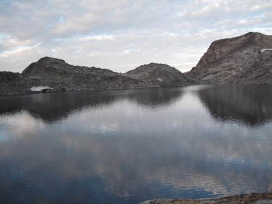
I've been to Lake Catherine, but only from the opposite direction (Waugh Lake). As I recall, there is a small glacier or permanent snow field that empties down into Lake Catherine, so there is a fair amount of glacial silt in the water. Lake Catherine is often the route for climbers to get up to the Ritter-Banner saddle.
If you are simply trying to get to Thousand Island Lake, I would think that it is much easier to get there from Gem Lake and Waugh Lake (from the June Lake Loop Road).
–B.G.–
Your right Lake Catherine is used as a route to the summit of Mt. Banner and hopfully part os my trip but I was wanting to go there from the Ansel Adams Wilderness side of the range.
Both sides of the Ritter Range are in Ansel Adams Wilderness.
–B.G.–
thanks I didn't know that. The stevenson trail starts from beasore road above Bass lake.
Yes, the Ansel Adams Wilderness extends to the East Side and the West Side.
–B.G.–
I haven't done that, or much of any off-trail in that area. When are you going and how soon afterward will be enjoy your trail report? :)
I have some time in september. Its a long way off but I want to go to Mt banner and this is one of the ways I thought of.
I have been over to Twin Island Lakes from Lake Catherine, and it's pretty easy. I understand there is a trail that comes up the canyon almost to Twin Island Lakes. They way to go is come up to the northern twin island lake, go to about its inlet, and then head up toward Catherine. There's a series of ramps and benches that will take you up to the Catherine outlet. That's the way we came down. It may be possible to go right up the outlet stream to Lake Catherine, but that looks steeper and trickier.
From Lake Catherine, it is very easy to get to 1000 Island – it's a big talus pile on the west side of the saddle and probably the same on the east (it was snow on the east when I came over there, but probably not this summer unless you get there real soon), and very gentle slope on the east side.
Isn't that part of the reverse or southbound Sierra High Route described by Roper between Blue Lake/ Bench Canyon and Lake Catherine. It's described in Roper's book in detail.
My reading and mapping and googling of the Sierra High Route in that stretch shows some interesting transitions with the level of the Twin Island Lakes being about as low as that stretch of the high route gets. Not sure how you'd approach twin island lakes from the Stevenson Trail or how difficult it is to get up to the @ 9500 foot level of benches the High Route follows.
I hope to visit Lake Catherine after Labor Day. Maybe we'll meet.
It is on the Sierra High Route!!
I'll hike it this august (southbound = same direction as you), so if I remember, I'll give you a post with a short report of the section by late August =)
thanks everybody. looking forward to that trip report.
Paul,
I will be doing this route next week. Can you provide more specifics. I understand that Roper is kind of vague on his route.
I will be going from Catherine Lake to Twin Island on a day trip while my friends climb Ritter again. Once is enough for me.
If you can attach or send separately a map of your rpute I would really appreciate your help.
I am experienced but don't want to get lost in the maze of those 400 foot cliffs etc.
thanks
Den – I don't have a good way to send you a map, but if you look at the topo map of the area and draw a line straight from the outlet of the pond just below the Cathrine outlet to the inlet of the northern Twin Island lake, you will be fairly close. from the outlet of that pond, you will contour and drop a little to the right, going over a sort of bulge that shows on the map; from the bulge you'll sort of work down and to the right to find and cross a little stream (although that stream could be dry at this point, so it might be just a gully) and you should be able to see the little knob/flat spot that shows on the map just at the 3200 meter level. If you aim for that flat spot, it puts you at the top of a ramp that leads right down to the inlet end of the lake. Some of that terrain seems steep, but it's all like a giant irregular staircase, so it's pretty easy to find a way up or down. just pay attention and take your time, and I suggest you look back up often so that when you are on the return it will seem familiar and it will be easier to retrace your route.
I recently went through this section on Roper southbound (eastbound). I recommend getting his book, for his description of the route. Although there are lots of complaints about how minimalist Roper's descriptions are, I found his notes for this particular section to be critically helpful.
The landscape is insanely and confusingly convoluted, not your typical Sierras granite ramps but something entirely foreign, especially right around the Twin Island Lakes themselves. I am pretty good at navigation but could not explain how I got from the lower Twin Island Lake to the start of the climb to Lake Catherine if my life depended on it – and I did it only 3 weeks ago. The upper (southern) Twin Island Lake is particularly scenic and is a worthy destination, but even getting from one of the Twin Island Lakes to the other is not straightforward at all.
With a full pack it took us a whole day to progress about 2.5 miles from the upper Twin Island Lake to Lake Catherine. There is one brief Class 3 section, but it wasn't intimidating. It is the tricky route-finding that slows you down. I don't dispute that there is a respondent on here who found it "easy" but no one we met who had gone through there had found it remotely easy.
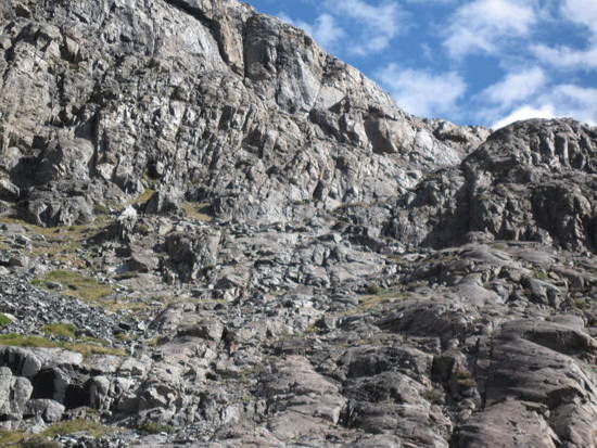
The pass from Lake Catherine to Thousand Island Lake is easy. The snowfields are to a minimum so the easiest passage at present is along the south/east side of the pass (in contradiction to R.J. Secor). Staying high on the south/east side for both the pass itself and for the uppermost mile of the eastside descent from the pass allows one to avoid the largest and most tedious of the talus.
– Elizabeth
Thanks, Elizabeth…
I have Roper plus I am pretty good at cross country hiking and navigation. But some of the trip reports at the various sites say the same thing as you… Confusing terrain at best.
I know the way from Catherine back home [since we come in that way] and that is no problem. I just wanted a little day hike excursion to Upper Twin Island Lake while my climber friends make their climbs… I will carry just a daypack with all the necessities, [just in case], so traveling will be easy in that regard.
I will wander around… if i can't do it easily, I will return. No heroics on my own.
Any ducks along the way that actually help? I am not a duck person but sometimes they work in tricky areas.
Denny
Do you have that trip report to share with us?
I am doing the route next week.
denny
Den,
Roper is actually pretty specific in this area. I'd follow what he says.
One exception is at the very start. I'm assuming your group will circumnavigate Lake Catherine on its north side, and then those who are climbing Ritter will cross Catherine's outlet and navigate along its west shore on the way to Ritter Lakes?
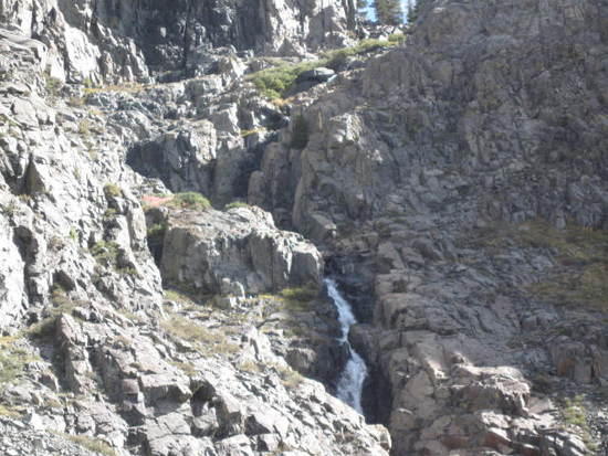
If so, ignore Roper's advice to follow Catherine's outlet stream to the tarn downstream. That tarn has steep terrain and is slow to navigate around. Instead, continue with your friends till you have reached about the midpoint of Catherine's west shore. Then, part ways and go due west over a little saddle. After descending from that saddle, you can easily cross the stream downstream from/south of the tarn. Continue west and find your way, per Roper, down class 3 ledges to the next-lower tarn fed by the waterfall. Roper's descriptions beyond that second tarn are actually pretty good and specific.
We only found ducks and faint use trails near the bottom of the route, where Roper instructs you to "contour" north instead of dropping further into the deep valley to the west of Mt. Ritter. Look carefully for those use trails – they will help you get onto the easiest ramps for the contour. The further you contour, the more convoluted the route will become as you approach the lower Twin Island Lake – up, down, around, backwards and sideways. Continue to follow faint use trails and a few ducks here and there and you'll wind up at the lake one way or another in some circular fashion.
You will reach the lower (northernmost) Twin Island Lake first. It might be worth simply exploring this lake, especially if you are short on time owing to navigating delays, rather than rushing on to the upper (southernmost) Twin Island Lake. We found the route between the two lakes very slow going.
If you do decide you have time to scramble up to the upper lake, walk due south from the lower lake briefly along easy terrain till you see a very steep chute ascending southbound but a bit left/east of where you might have expected. (To the left of the chute, the terrain immediately drops off to the huge valley below Mt. Ritter.) Once you ascend the chute, scoot around southwesterly till you hit the upper lake. The steep chute is the route we found between the two lakes – not to say it is necessarily the only route.
– Elizabeth
Photo of the chute between the lower and the upper Twin Island Lakes. Photo is shot looking southbound. Chute is on upper right. To the left is the dropoff to the valley below Ritter.

after posting this question I finially got around to the trip and decided to post some pictures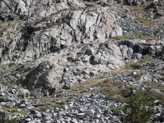


Hey, glad to see some photos. Can we hear how it went?
Hi Paul ater much thought i decieded to do the loop in in the opposite direction. I'll be doing a full trip report but I started off going over fernandez pass into yosemite. There was a trail going to the talus field from thousand island lake. I spent the night at lake cathrine what a place. At 9pm the cresent moon cast a beam of light right across the lake for about a half hour it was really somethine. The decent from lake cathrine in the morning was a lot of fun that I wont soon forget. From the last bench I found a trail leading to the bottom below twin island lake to the right of the waterfall. I alao saw old steel cable probably from some mining way back when. Going in the opposite direction would have been much more challenging.
Viewing 22 posts - 1 through 22 (of 22 total)
Become a member to post in the forums.
advertisementYour privacy is protected: We do not transmit your user data to third-party ad platforms or advertisers, and we do not host third-party tracking pixels. Backpacking Light serves ads on its own custom, native, and internal platform.
 Pro-Grade Water RepellencyPolypropylene face fabrics: see the future of raingear.