Topic

Bridge to Baldy loop, suggestions welcomed


Forum Posting

A Membership is required to post in the forums. Login or become a member to post in the member forums!

Home Forums Campfire Trip Planning Bridge to Baldy loop, suggestions welcomed

  • This topic is empty.
Viewing 9 posts - 1 through 9 (of 9 total)
  • Author
    Posts
  • #1289491
    Mitch Chesney
    Spectator

    @mchesney

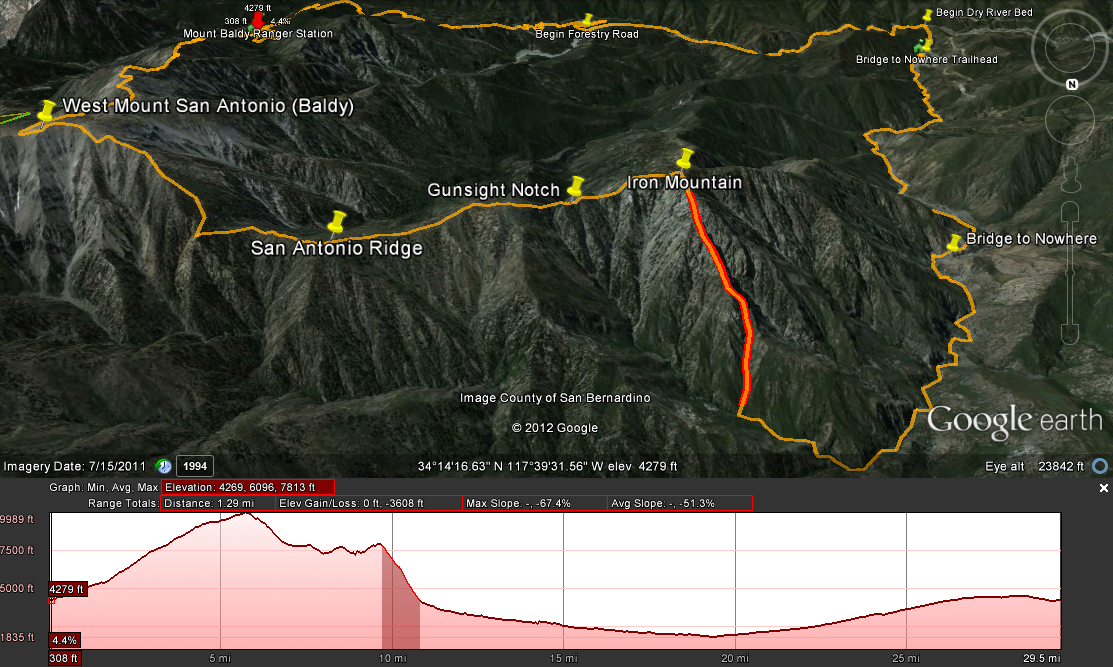
    I'm becoming a bit of a masochist – 5 days on the road for business and then a weekend full of bushwhacking. Soon as I step off the plane I'm heading over to the San Gabriels in southern California for a loop I've been planning (read: daydreaming) for a while. The trip would follow this itinerary:

    Friday
    0. 9pm Drive to Baldy Visitor Centre
    1. Start up Bear Canyon Trail to West Baldy (Mount San Antonio West)
    2. Camp overnight at summit

    Saturday
    0. 6am Pack out
    1. Hike along San Antonio Ridge to Iron Mountain (Sheep)
    2. Make my way down the north ridge and gully to Fish Fork
    3. Hike down The Narrows to Bridge to Nowhere for camp (where is suitable flat land around this area? I'm willing to climb a ridge)

    Sunday
    0. 6am Pack out
    1. Hike BtN trail to TH and follow the riverbed back towards Baldy. There is a two-track path along the riverbed.
    2. Take the connecting forestry service road over the ridge to the Baldy Visitor Centre
    3. Loop Completed (30+ miles)

    Preliminary Google Earth route (and elevation graph) here: http://29.media.tumblr.com/tumblr_m3ez7h0PfI1rv3ob8o1_1280.png

    #1873931
    W I S N E R !
    Spectator

    @xnomanx

    Sounds like a good trip. A few things:

    *Can't really camp at Bridge to Nowhere. It's "private" property for a half mile above it and below it, "owned" by a bungie jumping company. Expect 100+ college aged singles there to get "extreme" by about 9-10am in the morning. There are many obnoxious and abusive signs threatening you about its private ownership and how you can't stay there. They are periodically destroyed :)

    *There are plenty of cool spots to camp in the vicinity of the bridge though. Where Fish Fork meets the East fork, there is a good spot to camp.

    *Count on everything from Fish Fork to the East Fork to the Bridge to be fairly slow going. Trails are very eroded and overgrown in places, sometime nonexistant. It's totally passable, just don't expect to be flying down a maintained trail; lots of crossings, expect poison oak, and a bit of bushwhacking in places. Not being discouraging, just rough in places.

    Have a good one.

    #1873936
    Mobile Calculator
    Spectator

    @mobile-calculator

    #1873961
    W I S N E R !
    Spectator

    @xnomanx

    1997 was 15 years ago…Things have changed much for the better since then. It has been seriously cleaned up; I remember the days you are talking about.

    Yes, there are huge crowds on weekends and the associated issues, but that's typically only in the first few miles. I've only seen the trash you talk about around the parking lot.

    I camped up the East Fork with my daughter last weekend and generally go there a lot.
    There are a TON of private places to camp, well out of sight of the trail and other hikers. Heading home with her on Sunday morning at 8am, we passed 5 people on the way out, tops. Noon on Memorial day is a different story.You have to know the times and the sweet spots. Check my blog for endless picks of private campsites and beautiful canyon views on the East Fork.

    Baldy snow won't be an issue right now.

    #1873971
    Mobile Calculator
    Spectator

    @mobile-calculator

    #1873975
    Adan Lopez
    Spectator

    @lopez

    Locale: San Gabriel Valley

    Hey that's a fun loop. I'm sure you know what you're in for going from Baldy to Iron to Fish Fork…"fun".

    Depending on your shelter, maybe all you need is a small bivy spot and no fire. If so, then you could probably find a suitable place near the bridge as the river often has small, sandy beaches along its banks. Poach yourself a night right on the bridge itself, done! Of course, if you need room for a whole tent then you may have to go a bit further down toward the trailhead, but not far, about a mile down from the bridge.

    Have fun, hope you can find time to post up some pics/notes when you return.

    #1873980
    Mitch Chesney
    Spectator

    @mchesney

    Thanks everyone for your prompt responses. And from everyone's experience of the BtN I'm glad I've not gone yet, despite the urging of so many people. I expected high water but how would the narrows be? Navigable? Otherwise is it worth the risk of an expedient float downriver?

    #1873992
    Mobile Calculator
    Spectator

    @mobile-calculator

    #1873998
    Mitch Chesney
    Spectator

    @mchesney

    I've been following Skurka's advice on foot management and accept trail runners will get soaked (but dry fast). I'm just going to pack my down bag in a Sea to Summit dry sack and let water be damned. Then again, if there is a high trail and crossings will be minimal I may forgo the Sea to Summit.

    Edit: Oh yea I see it on the topo – Stanley Miller high trail on the east side. Will make sure to hit that :D

Viewing 9 posts - 1 through 9 (of 9 total)
  • You must be logged in to reply to this topic.
Forum Posting

A Membership is required to post in the forums. Login or become a member to post in the member forums!

Get the Newsletter

Get our free Handbook and Receive our weekly newsletter to see what's new at Backpacking Light!

Gear Research & Discovery Tools


Loading...