Hi all- we will hike south from Tuolomne, but would have to change airline tickets to give us time to exit at Whitney vs Kearsarge/Onion Valley, the current plan. Is that scenery toward the end among the best? The crowning glory of the hike, or more fabulous stuff? Thanks, Sam.
Topic
JMT exit advice: Kearsarge vs Whitney
Become a member to post in the forums.
- This topic is empty.
Viewing 10 posts - 1 through 10 (of 10 total)
This is just my opinion: DO NOT MISS MT WHITNEY!
Absolutely yes, the terrain from Kearsarge south to the summit of Mt Whitney, the highest peak in the lower 48 states, is stunning.
Here is a taste of what you would miss:
.
.
.
If all that is at stake is chaning a plane ticket, I would definitely do so.
Alternate perspective here:
My favorite part of the JMT is the section between Evolution Valley and the Bullfrog Lake/Kearsarge Pass area. (In other words, the entirety of Kings Canyon National Park.) I do not think the section from Kearsarge to Whitney is quite as drop-dead gorgeous by comparison. The miles through the Tyndall Creek area are even a bit tedious.
Try to do Whitney, of course. But if you have to cut it short at Kearsarge – a very pretty and well-graded pass to exit, by the way – IMO you will still have seen the best of the JMT. On your exit, try to camp at Kearsarge Lakes (rather than Charlotte Lake), and take the more southern trail to Kearsarge Lakes that passes through Bullfrog Lake. Outstanding views and gorgeous camping.
If you miss Whitney, it's easy enough to come back. A jaunt through Sequoia NP (along the High Sierra Trail, or maybe from Mineral King or Roads End), ending at Whitney, could make a very nice week-long trip in the future.
– Elizabeth
Hi Sam,
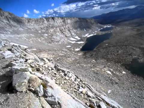
I did the JMT sobo last summer and wouldn’t skip the last part from Kearsarge to Whitney. After about 12 days on the trail it was easy going over the big passes (fully acclimatized and with only a few days of food weight). I felt totally immersed in the Sierra’s and was able to enjoy the trail without a single thought of the real world. In my opinion if you are already out there what better way to really enjoy the some of the good stuff? I’m partial to the Evolution area, but I really like Forester Pass, Diamond Mesa, Bighorn Plateau, watching the alpenglow on the east side Whitney and finishing at the top of Whitney. ‘Nuff said.

View facing north on the way up Forester Pass.

The trail heading south from the top of Forester Pass.

View facing south from Forester.

Bighorn Plateau.

Bighorn Plateau.

Camping on the west side of Whitney.

Watching the alpenglow on the west side of Whitney (from my bivy).

Sunrise on the way up Whitney.

West facing view from the Whitney trail.
If you’re interested here’s a short video taken from the top of Forester Pass:
(edited to add video link and correct east/west direction)
no video link embedded
I'm not sure if I added the embedded link to the Forester Video correctly. If not, here's the url:
Are there some easts and wests turned around?
Edit: Now it makes perfect sense.
Your shot of sunrise a mile before the summit is good. I have several like it, only slightly earlier in the morning so that the shadows are even darker. One of my favorite places.
–B.G.–
Andy, those pictures are great. What kind of camera did you use?
Don't miss either one. The view west from atop Kearsarge Pass is (IMO) the best of those from any of the 9 high passes on the PCT. (Neither Kearsarge Pass nor Mt Whitney are on the PCT).

and looking slightly more left of the sign, you can see the 2 small Upper Kearsarge Lakes, the much larger Kearsarge Lake below them, and Lower Kearsarge Lake below that. Bullfrog Lake is the most distant one on the right.

Thanks Sam & Bob. The trail toward the top of Whitney is surreal, the High Sierra awaits.
I just use a point and shoot Canon PowerShot Elph300HS. It's small/lightweight (4.8 ozs), 12 megapixels and has the same sensor as the P90 (but less than half the $). The quality is inconsistent and I usually end up doing some finishing in photoshop.
Viewing 10 posts - 1 through 10 (of 10 total)
Become a member to post in the forums.
advertisement
Small Business Sales Week

Discover deals from 90+ small outdoor brands during Garage Grown Gear’s Small Business Sales Week.
