“Sh!t… That’s a lot of wind…” I said to myself as I looked up the weather forecast for the Ventura County mountains where I had planned to do a quick overnight shuttle hike with a buddy:
Wind Advisory
URGENT – WEATHER MESSAGE
NATIONAL WEATHER SERVICE LOS ANGELES/OXNARD CA
231 PM PST THU JAN 26 2012
…GUSTY NORTHWEST WINDS TONIGHT THROUGH I-5 CORRIDOR…
…STRONG SANTA ANA WINDS EXPECTED FRIDAY AND SATURDAY…
.AN AREA OF BUILDING HIGH PRESSURE OVER OREGON AND IDAHO WILL
FIRST BRING GUSTY NORTHWEST WINDS TO THE LOS ANGELES AND VENTURA
COUNTY MOUNTAINS TONIGHT. THE WINDS WILL THEN SHIFT TO THE
NORTHEAST ON FRIDAY AND SPREAD INTO MOST OF LOS ANGELES AND
VENTURA COUNTIES…BEFORE WEAKENING LATER ON SATURDAY. THE
STRONGEST WINDS ARE EXPECTED FRIDAY NIGHT INTO EARLY SATURDAY OVER
THE MOUNTAINS…WHERE POTENTIALLY DAMAGING WIND GUSTS OVER 60 MPH
ARE POSSIBLE.
This was pretty much a trip killer. The planned hike involved spending the night amidst a fairly dense pine stand atop a high ridge; there was really not a lot of other options for a tree-free, sheltered camp in the area that you could reliably count on. With all of the fire damage over recent years, tree falls are a common occurrence on Los Padres trails even on fair weather days. The prospect of trying to set up camp amidst gusting winds while simultaneously hoping to not be spread out and asleep under a prospective widow maker was just too much unnecessary risk.
On the verge of canceling the trip, I began using the NWS detailed weather forecast site to hop around the entire southern Los Padres NF to see if I might find an area that was not as exposed to these potentially dangerous and destructive winds. After poking around a little, I discovered that just about 10-15 miles more or less due west from our desired hiking destination and a few thousand feet lower in the elevation, the wind forecast was cut in half. “30 mph gusts? I can deal with that.” So I made a couple of quick switches to packed gear to handle the wind a little better, updated my buddy on the revised plans and saved the day. We still had a trip! A few hours later, we were on our way up the winding 33 Hwy past Ojai and deep into interior Ventura and Santa Barbara Counties.
Where we ended up instead was a new area of the Los Padres for me. We would be hiking into the Dick Smith Wilderness from the northeastern side. I’ve hiked in the Dick Smith before, on the southern end, and had come to the conclusion that it was all lightly visited, poorly maintained and generally difficult to find reliable and easy vehicle access to the trailheads. If you wanted an “epic,” complete with crawling through brush, battling poison oak, dodging cantankerous rattlers and usually having to add a few miles of dull road walking due to various road closures, the Dick Smith was your place! Of course, it was also a reliable destination to find solitude and get a sense of true Southern CA wilderness.
Typical trail condition in Los Padres:
Not knowing what the interior side of the Wilderness area was like, I expected the worst as it’s even farther out into the middle of nowhere. The road to the trailhead lived up to the typical Dick Smith reputation of iffy access… a gated dirt road turned off the main highway and ran across the Cuyama River valley for about three miles, dipping in and out of various braided tributaries of the River throughout the (very) wide flood plain (in typical desert fashion, this flood plain can be running bank to bank swollen with muddy runoff, boulders, trees and various pieces of human civilization when the afternoon thunderstorms dump a few inches of heavy rain over a couple hour period mid-summer). The gate was open though, so we decided to try our luck at driving the road all the way to the trailhead. Luckily we took my truck and not Kevin’s car because the road crossed the River in about five or six places and most of the crossings were unimproved dirt crossings. Having made it through all of those without any trouble we came to one last obstacle standing between us and the trailhead, a big mud puddle that spanned the entire road bed. We backed up a little to get up a head of steam and gave it a go… luckily it turned out to not be very goopy and were able to get through it with little fanfare.
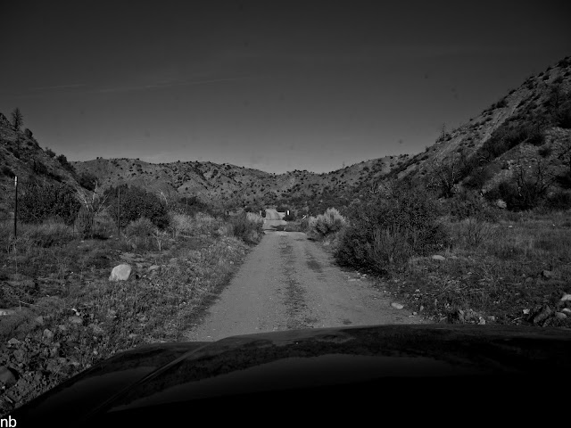
The trailhead is a non-descript clearing, next to the creek at the mouth of a canyon that didn’t really look like much of anything special. Just another canyon leaving the lowlands and entering the mountains that separate the interior valleys from the coastal plains. Oh well… we’re here, let’s give it a shot…

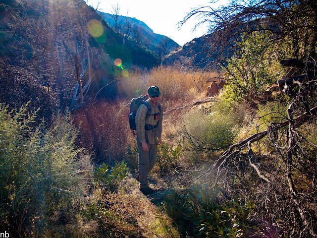
Getting a late afternoon start, we were hit with the harsh light and high afternoon sun beating down on us for most of the walk. Luckily for us, the walk ended up being generally flat, as it followed the creek upstream through a somewhat narrow canyon that got progressively deeper as we continued along. The canyon took some major meanders back and forth as it found the path of least resistance through the sandstone layers that comprise the surrounding mountains.


Both Kevin and I were a bit surprised by the scenery. It looked like what I imagine parts of New Mexico or Arizona to look like. Jagged, rugged canyon walls dotted with gnarled pines. The canyon floor was filled with tough as nails varieties of chaparral: Manzanita, chamise, coyote brush, wild rose, yerba santa, sage, and yuccas. Willow thickets colonized much of the muddy flats on either side of the creek, making for obscured creek crossings and requiring a little bit of route finding to pick up the trail again on the other side.

Surprisingly, aside from some of the creek crossings, the trail was in pretty good shape, especially considering the general lack of upkeep of trails in the Dick Smith. Turns out the Forest Service received funding after the Zaca Fire which burned almost the entire southern Los Padres in 2007 and put a bunch of that money into trail work and new signage (I found it somewhat amusing that the generally least visited and least maintained areas had the nicest signs in the entire forest). Still, very little work, if any, had been done since other than occasional foot traffic, and the dense thorny thickets of wild rose (yes, it’s just as thorny as its domesticated relative) were starting to crowd in on the trails and re-claim the thin single track threading its way up the canyon.

The Forest Service’s resources are spread woefully thin and they can’t really keep up with the trail maintenance demands in most of the forest, so we typically bring a set of loppers and a pruning saw or two with us on every trip to clear blow downs and generally clip up some of the encroaching brush so that these trails don’t end up lost to the scrub until the next fire. Ultimately we ended up clearing about 15 blow downs up to about 16” in diameter from the trail, making it passable for stock users and more accessible for other hikers. We also spent some time pruning back the encroaching brush. (There’s a loose group of regular LPNF hikers who went in on a group purchase of arborist quality pruning saws to bring along on hikes and help clear blow downs and prevent the trails from all together vanishing; many in the group are Volunteer Wilderness Rangers and do much of the trail maintenance over weekend trips on behalf of the FS; all told I think there’s about 20 hikers floating around the LPNF with one of these saws.)
One Blow down blocking the trail:

The Silky Big Boy 2000 (classic name for a saw!) made quick work of it:
A couple of hours into the hike and after innumerable muddy and brushy creek crossings, we came upon a section of the canyon where the walls closed in and the creek had carved out a rocky “V” through two sandstone ridges. Both sides of the narrows were riddled with shallow caves amidst the sandstone crags just begging to be explored, looking for signs of civilizations past. Just through the other side of the narrows, the canyon opened up into a wide open potrero (Spanish for meadow or pasture land) bordered on all sides by more craggy sandstone peaks.


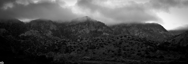
We arrived at the potrero right at the start of that golden hour of late afternoon sunlight that turns the grass the color of gold and lights up the sandstone in hues of pink and orange.

Around the same time, the forecasted Santa Ana winds began to pick up, weaving their way up the twisted canyon and blowing in the Tule fog off the Cuyama River valley to our northeast. Fingers of the dense fog wrapped around the peaks towering above us but luckily stayed high and never settled into our potrero. After setting up camp at the old hunter’s camp site in the cottonwood thicket by the creek, we spent the last hour of daylight wandering the meadow, exploring the caves and enjoying the light show being put on display by the fog and setting sun interacting with the surrounding landscape.
I spent a while shooting various scenes until the sun sunk behind the craggy peaks off on the western horizon:


The Santa Ana winds are a dry offshore wind that blows towards the coast from the inland Southern CA deserts. It’s typically a very dry, very warm wind and is responsible for fanning many of CA’s most destructive wildfires. Given the forecasted wind event, we expected temperatures to hover around the mid to low 40s overnight, artificially warm for a January night at 4,000’ elevation. As the night crept on however, the winds unexpectedly laid down and with it, the temps plummeted dramatically and humidity rose as we were camped on the border of a giant meadow. Soon we were inching a little closer to the campfire and adding what meager layers we brought with us, hoping to fight off the chill of what was turning into a slightly damp 30 degree night.
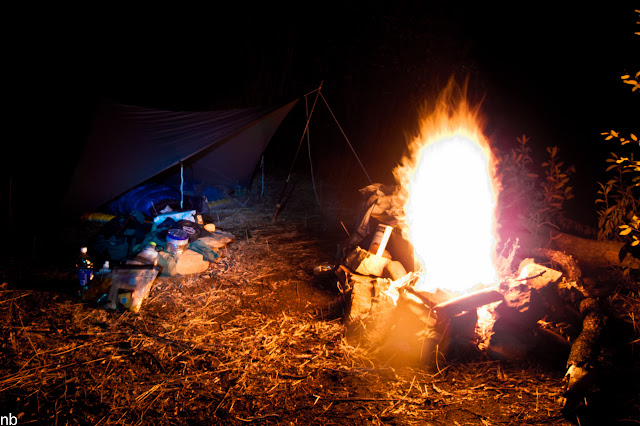

Soon enough, the embers of the fire were dying out and the Islay single malt had all been drained and so we opted to turn in. The night passed uneventfully, marveling at the starlit sky and listening to coyotes and other wildlife call out during the night, making their rounds through the potrero, playing the part of either the hunter or the hunted. In the wee early morning hours, well before sunrise, I seemed to have bottomed out on the comfort range of the sleeping kit I brought with me and had to throw on my wind jacket and drape my down sweater over my legs under my quilt to fight off the chill. The added layers seemed to have done the trick and I managed to get a little more shuteye before climbing out from under the tarp to greet the morning and watch the sunrise light up the surrounding peaks. Kevin meanwhile had burrowed deep into his mummy bag and not even his nose seemed to be poking out of the hood.

Saturday morning, we slowly packed up camp and pieced together a vague plan to follow the creek upstream and generally just explore the area. The creek continues up through the potrero, winds its way through a couple of “S” turns and continues on deeper into the depths of the Dick Smith Wilderness. The canyon floor stays fairly wide and allows for relatively easy off trail walking aside from the occasional sections of chest high wading through sage scrub. We eventually left the canyon floor and scrambled up a series of steep game trails to some sandstone monoliths up along the ridgeline. From the vantage point, we enjoyed views back over the country we had just come through.


After a brief respite, we scrambled back down the slope and out of the ravine and back into the main canyon to start the trip back out. On our walk back towards the last night’s camp, we were rewarded with the discovery of an arrowhead! Unfortunately, it was a modern deer stalker’s arrowhead and not of the Native American variety. Oh well…

The walk back out passed pleasantly. We continued to clear some of the blow downs we had left for the way out, lopped some encroaching brush, picked up any trash we found along the way and generally enjoyed the scenery and solitude.


Cruising at a leisurely pace, we arrived back at the trailhead in the early afternoon, loaded up the rig, ran the gauntlet of mud holes and creek crossings back to the highway and then hit the local watering hole for a well earned cold one. All in all, the trip ended up working out just fine!


