


I think I would like the product but the process is too tedious for my liking.
Topic
Become a member to post in the forums.
I think I would like the product but the process is too tedious for my liking.

GBC makes ultra-thin laminating pouches that can be used (with the paper carrier supplied) with cheap heat laminators like "Duck" brand found in Walmarts. I use the ones for letter-sized paper, and only had a problem once, when I left the space between the paper boundary and the pouch boundary too narrow, and the seal failed, in the pouring rain of course. "Map rot," said my trekking companion. It is quick and easy.

Daryl: Thanks for posting. It's nice to know that if I was away from home, I could make waterproof maps in a hotel room after a trip to any grocery store. Usually, my time is worth more than that, since I keep "Rite in the Rain" paper around and it is somewhat light (6.4 grams / 8.5"x11" sheet) and cheap ($0.15/sheet when bought in 200 packs). But in a pinch, or for 2 or 3 copies, that's a nice trick.
Now to REALLY save weight and multi-task your gear, use that technique to get get ink onto 8.5"x11" sheets of plastic, but then bond them onto your trash-compactor liner bag so you have a multipurpose pack-liner, map, emergency poncho, lower-leg bivy sack, funky rain hat, and trash bag.
Bonding them together onto a larger sheet also solves the edge-of-the-map problem*.
Seems there should be a tradition of handing off northern maps to southbounders and vis-a-versus on the AT. But I'd assume many more people go north to optimize the seasons as all through hikers on the PCT have to do.
*You know that Greenwich England is located where it is in order to maximize map sales? Because 0 longitude is there, all moderately interesting places all on the edges of two maps and the really cool places are at the corners of four maps.**
** You know that the above is a joke and Greenwich is at 0 because the English solved the Longitude Problem first? My father read "20,000 Leagues Under the Sea" in the original as a boy and tried to track the progress of the Nautilus. Which at times seemingly went under land. Because the French, being French, thought Paris was the Prime Meridan.
"so you have a multipurpose pack-liner, map, emergency poncho, lower-leg bivy sack, funky rain hat, and trash bag."
Good thinking. It is time for the blank spaces of our gear to be filled with useful info (e.g. plant and animal id info, emergency phone numbers, Group Health #, sexual preferences, medical info, etc.)
> It is time for the blank spaces of our gear to be filled with useful info
Daryl, Agreed. Other have commented on WWII flyer's jackets which had silk liners printed with maps of occupied Europe. Silk micromaps were also printed and smuggled to POWs in game pieces in care packages. And a few national park maps are mass produced on bandanas.
But what about human skin? 1.8 sqaure meters for an average adult. So that's 30 printer pages of area. It would save 200 grams. Totally waterproof. Prisoners have DIY tattoos all the time and those of us on the Outside would have more choices for ink colors.

It could be a new icebreaker around the shelters, "I'll show you my AT if you show me your CDT."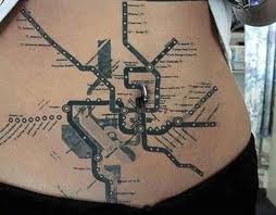
Which begs the question do you get the tattoos upside down for easier self-use or right side up for easier sharing of the information?
Love it…even if it is a bit difficult to use a belly tatoo in the winter…Ha, ha!
Wow, this is getting better and better. May have to move it to Chaff Forum shortly. (This is meant as a compliment.)
Become a member to post in the forums.
 New Ultralight GearSee the latest releases in ultralight cottage-brand gear from small makers.
 © Beartooth Media Group Inc.
 Loading...