Topic

Sierra: Horseshoe Meadow to Whitney Roundtrip?


Forum Posting

A Membership is required to post in the forums. Login or become a member to post in the member forums!

Home Forums Campfire Hiking Partners / Group Trips Sierra: Horseshoe Meadow to Whitney Roundtrip?

  • This topic is empty.
Viewing 21 posts - 1 through 21 (of 21 total)
  • Author
    Posts
  • #1278840
    Randall Johnson
    Member

    @tsunami

    Locale: Southern Nevada

    I am fairly lightweight at just over 25 pounds with gear for up to 4 days comfortably. This does not include water which I will purify regularly along the way.

    Has anyone done this route due to difficulty and cost coordinating a shuttle between Whitney Portal and Horseshoe Meadow not to mention the permit nightmare entering the portal side?

    I am in excellent shape, very strong and fast and am a cyclist. I regularly climb and hike over significant distances. 15 miles daily does not seem at all out of the realm of possibility as I have done more.

    Ideas? Feedback.

    Thanks everyone. Trip dates are planned for 9/6-9/9 at the latest.

    #1775572
    Ken Helwig
    BPL Member

    @kennyhel77

    Locale: Scotts Valley CA via San Jose, CA

    You might not need to shuttle….Though the road to Horseshoe is rather slow, almost all people driving up to the trailhead are hikers, I would bet it would be real easy to at least hitch to the intersection of the road that takes you to Whitney Portal. One wrinkle that you might really want to do if you are comfortable on cross country, is going through Mitre Basin, through to Cottonwood Ranger Station. However or wherever you go it is sublime scenery up there! Jealous. I leave on my own little jaunt tomorrow morning going over Kearsarge, over Junction Pass, Shepherds then Forrester and back in 4 days. Have fun!

    #1775573
    Randall Johnson
    Member

    @tsunami

    Locale: Southern Nevada

    Sweet! Sounds awesome! Thanks Ken! So you suggest doing the loop and coming out Whitney portal and walking the road and try to hitch a ride back to my car at Horseshoe Meadow? Or maybe park at Whitney Portal early and try to hitch a ride to Horseshoe Meadow first before the start. This may make more sense actually I think. I probably will avoid the cross country at this point as I was made to promise before this trip was "approved" that I would not do this since I am alone *sigh*.

    #1775579
    Anonymous
    Inactive

    "This may make more sense actually I think. I probably will avoid the cross country at this point as I was made to promise before this trip was "approved" that I would not do this since I am alone *sigh*."

    That is unfortunate, because the simplest way to do the route would have been to do an out and back via Cottonwood Pass thru Miter Basin, over Crabtree Pass and up the scree slope above Upper Crabtree Lake. All it would take from the bureaucrats is a Whitney Zone permit on your Cottonwood Pass wilderness permit. That way you wouldn't have to deal with the uncertainty of hitch hiking and, for a guy in your shape, it would be an easy 3 day jaunt with a slack day to hang out and maybe fish in Middle Crabtree Lake. The fishing there is excellent and the eating of same even more excellent.

    #1775584
    Randall Johnson
    Member

    @tsunami

    Locale: Southern Nevada

    In light of this I may attempt to negotiate better terms especially if I can support it and show it to be generally "safe" but probably not as much as a marked trail can be so to speak.

    #1775596
    Anonymous
    Inactive

    "In light of this I may attempt to negotiate better terms especially if I can support it and show it to be generally "safe" but probably not as much as a marked trail can be so to speak."

    Randall,

    The route over Crabtree Pass is done pretty frequently and is easy if you are comfortable off trail, pretty much class 1 with a couple of short, easy class 2 stretches on either side of Crabtree Pass. The scree slope I mentioned is a walk up, strenuous but still a walk up. It will pop you out on the Mt Whitney Trail just east of Trailcrest Pass. Coming down the scree slope is easy walking and an absolute blast to run if you're in the mood. Very exhilarating. It is approximately 16 miles to Upper Crabtree Lake from TH and you can easily find a spot to bivy on a flat patch among the boulders between Upper Crabtree Lake and Middle Crabtree Lake. This will put you in position to summit on day 2, with the option of hanging out for a day before returning, or even going partway out on day 2. The are good bivy sites around both Erin and Primrose Lakes above Miter Basin that will lessen your chances of a bear encounter. It's a delightful trip thru some really beautiful country, much better than slogging along with the masses on the main trail down to The Portal.

    #1775613
    Randall Johnson
    Member

    @tsunami

    Locale: Southern Nevada

    Looks like over Cottonwood Pass/Siberian Trail/ Soldier Lakes/ Sky Blue Lake/ Crab Tree Pass/Upper Crab/ Discovery Pinnacle ect. Seems pretty straight forward and looks magnificent from photos. Visits from bears are not on my list of favorite Sierra experiences. I have a BA UL Fly Creek2 so would be looking for suitable terrain for my four star hotel :) Other than that I would like to take the route less traveled…out and back of course ;)I greatly appreciate the feedback and help!

    #1775759
    Anonymous
    Inactive

    "Looks like over Cottonwood Pass/Siberian Trail/ Soldier Lakes/ Sky Blue Lake/ Crab Tree Pass/Upper Crab/ Discovery Pinnacle ect. Seems pretty straight forward and looks magnificent from photos."

    Sounds to me like you've got the route dialed in. Yes, it is magnificent, and far from the madding crowd. ;-)

    "Visits from bears are not on my list of favorite Sierra experiences. I have a BA UL Fly Creek2 so would be looking for suitable terrain for my four star hotel :)"

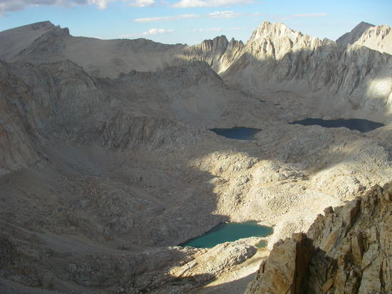
    You should be able to find a suitable location somewhere between Upper and Middle Crabtree Lakes, and I doubt you'll have much problem with bears there. Down below Middle Crabtree Lake is another matter. Also, Miter Basin, including the area around Sky Blue Lake is definitely bear country. Your best bet for avoiding them if you decide to camp in the area is to bivy at either Erin or Primrose Lakes, up above the main basin. If you are not carrying a bear canister, though, I'd push on to Soldier Lakes at the headwaters of Rock Creek if you are going part way out on the second day. There is a bear box there and it's only another couple of miles of easy hiking. The other alternative is to hang out in the Crabtree Lakes area the rest of day 2 and go all the way out on day 3 or 4. However you choose to do it, have a great trip. You'll be going thru some prime real estate.

    #1775840
    Randall Johnson
    Member

    @tsunami

    Locale: Southern Nevada

    So this will be the plan then. Thanks Tom for your help. I do plan to head back on day two to the Soldier Lakes area and out sometime on the third day. Depending on logistics and arrival time I may add a day by sleeping at Chicken Lake the first day. We shall see. I was wondering about a good spot to park the second night- Soldier Lakes it is. Total pack weight without water and bear canister but including everything else is 23.5 pounds. Should be a blast!

    #1776013
    Anonymous
    Inactive

    Hey, Randall, the hard part is over. You've got a good plan dialed in. Time to rock n' roll! Have a great time, and let us know how it turns out. :)

    #1776079
    Dave T
    Member

    @davet

    View of that area from summit of Mt. Pickering (ca. 13,500'), with Whitney in the background. It's lovely up there.

    pick view

    #1776270
    Anonymous
    Inactive

    "View of that area from summit of Mt. Pickering (ca. 13,500'), with Whitney in the background. It's lovely up there."

    Nice shot, Dave!

    #1776327
    Jesse H.
    BPL Member

    @tacedeous

    Locale: East Bay, CA

    I just did this very hike two weeks ago! amazing trip… although I had to deal with alt. sickness which was not most fun… after a bit of a backpacking break, this trip has revived and renewed my spirit… have fun!

    #1778262
    Randall Johnson
    Member

    @tsunami

    Locale: Southern Nevada

    Had an absolute blast! Trip was basically an "8" as I wanted to see as much as possible in the allotted time and avoid passing the same areas.

    11AM Sunday started Horseshoe Meadow-Cottonwood Pass-Upper Soldier Lake (the smallest one where the vista of the Mider Basin can be seen beyond). Monday- Crossed the Mider Basin and up and over Crabtree Pass and dumped my gear in the rocks at the bottom of uppermost Crabtree Lake. Took a waist pack directly up the sand to Discovery Pinnacle and on to Whitney Peak. Was up there alone on Labor Day lol!! Rode the endless sands back to my gear racing the deteriorating weather and slept at middle Crabtree after deciding against going back across the Mider the next day. Felt a bit queasy that night but it was gone by the morning. Tuesday woke after a bit of rain and departed to Crabtree Meadow and then South over Goyout Pass and had a blazing inferno going at Rock Creek night three. Slept the best this night and it was the warmest of the three. Wednesday- Departed Rock Creek 9500 feet headed for New Army Pass showing 7 miles or so, changed plans dumped my gear in the rocks at Old Army Pass and ascended Langley. Grabbed my gear and exited before sunset out of the Cottonwood lakes trail system. I ended up somewhere in the 40's on mileage and felt like I saw much this area has to offer and it was a real pleasure. The heaviest my pack 28lbs and by the last day I'd be surprised if I was more than 23 including the bear can and I had a full bag of dried fruit left over.

    It was a total blast and so was the drive through the Panamint Mountains out of Death Valley on CA190. German engineering ;) What an amazing drive with well over 15 miles of unbroken exceptionally steep and windy curves through the Panamint Range and the steep valley in between. Pure bliss! Beautiful and treeless offering stunning vistas at every turn. Thinking back on it, this actually makes sense as I was climbing from the lowest place on earth to the highest point in the continental U.S. and I don't think there is more than 75 miles in between these two places. I am glad I ignored the NAV's suggested route of boring interstate that added 88 miles to the trip each way. I had a grin from ear to ear when I approached the first series of signs reading "Steep and Dangerous Curves Next 15 Miles". The drive up to Horseshoe Meadow was equally impressive and the GTI performed admirably.

    My buddy refused to go with me on this trip as he claims I put too much mileage in for his taste :( Oh well, I met lots of cool and interesting people along the way and hope to visit the area again soon. Thanks Tom and the rest for the feedback. Looking forward to many more trips in the coming year. Some pictures:

    #1778263
    Randall Johnson
    Member

    @tsunami

    Locale: Southern Nevada
    #1778530
    Anonymous
    Inactive

    "Had an absolute blast! Trip was basically an "8" as I wanted to see as much as possible in the allotted time and avoid passing the same areas."

    Right on, Randall, you really nailed it! Congratulations on doing a great route in style. And thanks for sharing your experience.

    #1778537
    Ken Helwig
    BPL Member

    @kennyhel77

    Locale: Scotts Valley CA via San Jose, CA

    right on Randall…sounds like you had fun!

    #1790986
    Anonymous
    Inactive

    Jeff,

    This is the thread I was referring to yesterday evening. You should find pretty much everything you need here to help you decide if this route suits you. Except for a map(Mt Whitney 15' series for planning-Tom Harrison for field use).

    Tom

    #1790999
    Jeff M.
    BPL Member

    @catalyst

    Thanks. I found it late last night. This will be helpful. Now to begin the whispering in my wife's ear so she lets me leave her with the two kids. ;)

    #1791025
    Anonymous
    Inactive

    "Now to begin the whispering in my wife's ear so she lets me leave her with the two kids. ;)"

    They have a saying in my wife's part of the world: "Slowly, slowly, catchee monkey". ;)

    #1791116
    Dana Sherry
    BPL Member

    @dsherry

    Locale: Southwest

    album requires password-locked.

Viewing 21 posts - 1 through 21 (of 21 total)
  • You must be logged in to reply to this topic.
Forum Posting

A Membership is required to post in the forums. Login or become a member to post in the member forums!

Get the Newsletter

Get our free Handbook and Receive our weekly newsletter to see what's new at Backpacking Light!

Gear Research & Discovery Tools


Loading...