Topic

Above Tree Line Southern Sierra


Forum Posting

A Membership is required to post in the forums. Login or become a member to post in the member forums!

Home Forums General Forums General Lightweight Backpacking Discussion Above Tree Line Southern Sierra

  • This topic is empty.
Viewing 25 posts - 1 through 25 (of 27 total)
  • Author
    Posts
  • #1275768
    Chad Eagle
    Member

    @eaglesd

    Locale: SoCal

    I am looking for suggestions and ideas for a 5-Day(give or take a day)trip in the southern sierra that stays above tree line for the majority of the trip. Established trails, cross country, or combination of the two are fine. I would also prefer to enter from the east side. Any ideas?

    I should also add, I generally avg. between 20-30 miles a day on trail when gain/loss isn't crazy. Example: avg. 20-24 miles a day on JMT. So I understand mileage will have to be cut if dealing with c/c routes. I also tend to put in long days.

    #1751815
    Anonymous
    Inactive

    Chad,

    There are many options for you, given your parameters. The main passes, beginning with the southernmost, are: Cottonwood; New Army; Mt Whitney; Shepherd; Kearsarge. All of these passes will give you entry to the southern Sierra and a wide choice of routes either totally on trail or a combination of on/off trail. Cottonwood and New Army have the advantage of starting at 10,000' and offer access to Miter Basin and Crabtree Lakes if you don't mind doing a little off trail travel. Lower and Middle Crabtree Lakes offer excellent fishing and also an elegant exit via the Mt Whitney Trail if you don't mind slogging up a ~2,000' scree slope or circling around through Crabtree Meadows to pick up the JMT, and can obtain a Whitney Zone Permit. Mt Whitney is the standard route up to Mt Whitney and is usually booked long in advance. It can also be used to enter the Kern Basin, but I personally don't much care for it and its hordes of people. Shepherd Pass, my favorite, is a very strenuous route that offers the shortest access to the Upper Kern Basin. You could go in there and spend a day or two exploring some of the finest country in the entire Sierra. Personally, I think 5 days is a bit short to do it justice, because it will likely take you 1.5-2 days to get in there unless you are in super shape. Assume 1.5 days to get in and 1 day to get out still leaves you 2.5 days to explore the Upper Kern Basin and Milestone Basin, which would be about as quality a 5 day trip as I can think of in the southern Sierra. Further north is Kearsarge Pass, which starts at just over 9,000' and tops out at ~11,700' and offers entry into the Bubbs Creek drainage. That is a beautiful area as well. You could easily spend your 5 days in the Bubbs Creek drainage, or drop down to the JMT and head south over Forester Pass(~13,400') to the Tyndall Creek trail where you would turn east and exit via Shepherd Pass. This would require either a shuttle or a fairly long hike back to your car at the Kearsarge Pass TH. Be aware that bear canisters are required on all the abovementioned passes except Shepherd, IIRC. Check with the White Mountain RS or The Eastern Sierra Interagency Information Center just south of Lone Pine for the latest beta.

    There are a lot of other side trips you can take once you get back into the Upper Kern Basin, e.g. Wright Lakes Basin, Wallace Lake Basin, Lake South America, etc. I'm sure others will add their ideas to this thread, and if you want further info from me, either PM me or post here and I'll elaborate on it as best I can.

    Tom

    #1751826
    Dave Jenkins
    Spectator

    @jinx667

    Locale: NC

    A group of us are doing 7 days starting at Onion valley to Vidette Meadow, via Kearsarge Pass; to Tyndall Creek via Forester Pass; to guitar lake, summiting Whitney, back to Guitar Lake; , to Rock Creek via Crabtree Meadow; to Chicken Springs Lake; and then exit via Horseshoe Lake via Cottonwood Pass. It could be done in way less than 7 days, but we are not in a hurry. Should be a lot of time above the trees on this one.

    The map that covers this area is the Tom Harrison: Sequoia & Kings Canyon National Parks recreation map.

    #1751837
    Chad Eagle
    Member

    @eaglesd

    Locale: SoCal

    @ Tom, what is the mileage from trailhead to Upper Kern using Shepard Pass? Also, will I be able to stay high once in the basin? I am hoping to find somewhere to go where once I get up high I can stay high with either c/c routes or trails and forego any ups and downs. I prefer entering from the east , but if the easiest access is from the west that is fine. I have looked at this area before, but have never put anything together, or really looked into the details of the area. How is the access from the west from the Roads End area?

    #1751872
    Anonymous
    Inactive

    "@ Tom, what is the mileage from trailhead to Upper Kern using Shepard Pass?"

    Chad,

    It is ~18 miles, but that can be deceptive. To go over Shepherd Pass you will gain ~6300', topping out at 12,050'. You can go all the way in to the Upper Kern in one day if you are in good shape and acclimatize well, but most people will stop either at Anvil Camp or a bivy site another 800' higher above a feature called "The Pothole". About a mile or so west of Shepherd Pass there is also another excellent, seldom used campsite by a lake at the base of Diamond Mesa. Its elevation is about 11,750' or so. Once back in The Kern Basin, you can stay above 10,000' entirely. There are numerous possibilities, e.g. go up to Lake South America then across to Wright Lakes Basin and Wallace Lake Basin, or over Milestone Pass(~12900') and down into the Kern-Kaweah River valley. If you follow the Kern-Kaweah river downstream, you will have to descend into Kern Canyon at 8000', but will quickly be back up above 10,000 on your way to Wallace Lake Basin/Wright Lake Basin, or even Mt Whitney. Besides, the Kern-Kaweah River valley is absolutely gorgeous and well worth the trip, and Milestone Pass will give you a very good workout in the bargain.

    If you go in from Roads End, it is about 28 miles to the Upper Kern over Forester Pass. If you choose this entry/exit, a very nice loop would be to go cross country over Harrison Pass then down to East Lake and out via Junction Meadow(Bubbs Creek version). With the kind of mileage you are capable of, this would be a good 5-6 day trip with a day to explore Milestone Basin, which is a beautiful basin, indeed. Alternatively, you could exit the Upper Kern Basin via Thunder Col, just below Thunder Mtn and go cross country over Longley Pass, past South Guard Lake and over an unnamed col into the Sphinx Lakes Basin, then on down to Roads End. Whichever way you choose to enter, you will be going into some of the finest country in the entire Sierra. I can pretty much guarantee you will come back for seconds. An adjacent area that would require a bit more time is the area along the Great Western Divide, from just north of Milestone Basin on down to Big Arroyo Creek, including Kaweah Basin. Lots of cross country routes there that are well worth doing. But those are for another trip, given your time constraints.

    One further note: Going over Shepherd Pass is definitely more difficult, but shorter. Roads End is a longer, by 10 miles, but easier route. Also, IIRC, you will have to carry a canister on the Roads End/Bubbs Creek route. Check with the ranger station, as I haven't been on the Bubbs Creek route in years. Too crowded and too many bears for my taste.

    #1751883
    Chad Eagle
    Member

    @eaglesd

    Locale: SoCal

    Thanks Tom. Can you tell me a little about Diamond Mesa and Wright Lakes Basin. I think I would like to stay up in that area for a day or two before going into Milestone, or perhaps on the way out. I have been into Kern Canyon and over in the Big Arroyo on previous trips and did enjoy them. I believe I can make it into Milestone in a long day, based on your mileage and elevation description, but hitting Diamond Mesa or Wright Lakes might ease the first day mileage. Any routes from Shepherd Pass trail into Wright and or Diamond Mesa?

    #1752240
    Anonymous
    Inactive

    "I think I would like to stay up in that area for a day or two before going into Milestone, or perhaps on the way out"

    If it were me, I would go for Wright Lakes Basin. It is by far the prettier of the two locations. Diamond Mesa is basically a high barren plateau with ony views of Junction Peak and Bubbs Creek drainage to recommend it. Wright Lakes Basin is dotted with lakes and is a nice place to hang for a day or part of a day. Coming off Shepherd Pass, just head for the low spot on the ridge leading from Mt Tyndall and Tawny Point. You will pick up an old horse packers trail which will lead you into the basin. It is much shorter than contouring around Tawny Point and following the JMT to Wright Creek. An even better option, IMO, if you think you can make it all the way to Milestone in one day would be to do just that. Then you could head on up Milestone Basin and cross Milestone Pass into Milestone Bowl on the second day. The third day you could drop down to the Kern Kaweah River and follow it down to Junction Meadow, possibly continuing on up to the campsite at the junction of the JMT and Wallace Creek. On the 4th day keep going up Wallace Creek to Wallace Lake and camp there. It is only 4 miles or so, which would leave the rest of the day to scramble up Mt Barnard(~13,984'), or explore up around Wales and Tulaynyo Lakes. The 5th day you could hike cross country across the ridge that separates Wallace Lake and Wright Lakes Basins and on out over the previously mentioned col between Mt Tyndall and Tawny Point. From there it is an easy, mostly downhill 12-13 miles to trail head via Shepherd Pass. This suggested possible route would put your conditioning and off trail skills to good use, but take you through some marvelous country for your efforts. You could also stop at Wright Lakes on the way in and reverse this route, or do some other variation involving more time in the Upper Kern Basin. There are several possibilities, as I mentioned in my previous post, but this one would really give you your money's worth in 5 days, or possibly six if you wanted to take an easy day somewhere along the way. The biggest challenge, IMO/IME would be getting all the way to Milestone Basin on the first day. It is only 18 miles, but the altitude gain from ~6,000'-12,000' will test you. I know it did me. Milestone Pass is strenuous, but technically easy, and Milestone Bowl is one of those high wild basins you will long remember, a great place to camp for a night.

    As for routes up to Diamond Mesa, just pick your line and scramble up the loose, rotten scree and boulders. It's a grungy affair, but not technically difficult.

    #1752314
    obx hiker
    BPL Member

    @obxer

    I have a few questions and maybe a suggestion associated with this thread.

    1. Anyone here been up to Picketts Guard Lake from the Kern Kaweah, Colby Pass Trail?
    2. Anyone seen or heard of "Little Joe Pass" which is a route down a col between Milly's Foot Pass and Lucy's Foot passes going across the Kings kern Divide right where it makes the 90 degree turn between Genevra and Ericksson? http://www.scaruffi.com/travel/colby.html
    3. Anyone been over McLeod Pass?
    4. Anyone been up the east spur of Mt Brewer and over to the Brewer Basin?

    Tom I believe the "un-named pass between South Guard Lake and the Upper Brewer Basin was named Cinder Col by RJ Secor "after an old flame" presumably named Cindy? (The High Sierra Page 134) Secor coined quite a place names. Check page 29

    Chad it may sound strange until you look at it awhile but Marvin Pass to Colby Lake is 22 to 24 miles and should be a lot faster with very moderate and gradual elevation gain. Might make sense if coming from the west is easier for you. Puts you at the foot of Milestone Bowl and you could loop back vis Thunder-Longley or Harrison-Longley or the mysterious Little Joe-Longley and down Brewer Creek to Roaring River and out. 2 days going and coming to the above tree-line part but some intersting scenery.

    Longley will likely have a cornice to negotiate until very late this year so check that out and Thunder Pass also holds snow very late or so I've read.

    #1752332
    Chad Eagle
    Member

    @eaglesd

    Locale: SoCal

    @ Tom, Thanks for the info. I think I will sit down and look at the maps for awhile and double check the calendar before deciding my route. At the moment you have sparked my interest in Milestone and Wright basins. Can you recommend any particular maps for the area? How are permits for Shepherd Pass, ie; do they go fast, time frame to get permits prior to trip?

    @Cola, as mentioned above Tom has me sold on this area and entering from the east. Sounds like a good challenge pushing up to Milestone in a day. I will definately keep your ideas in mind for future trips, Thanks.

    #1752592
    Anonymous
    Inactive

    "1. Anyone here been up to Picketts Guard Lake from the Kern Kaweah, Colby Pass Trail?"

    If you're referring to the, I thought, unnamed lake in Kaweah Basin about 1 mile south east of Pickett Guard Peak, yes. 6 times. There are numerous ways to get in there, 2 of which leave the Colby Pass trail 1/4-3/4 miles west of Rockslide Lake.

    "2. Anyone seen or heard of "Little Joe Pass" which is a route down a col between Milly's Foot Pass and Lucy's Foot passes going across the Kings kern Divide right where it makes the 90 degree turn between Genevra and Ericksson? http://www.scaruffi.com/travel/colby.html"

    No, but I have never much cared for any of the 2 other passes between Genevra and Ericsson. Thunder Col and Harrison Pass are much less dangerous and offer access to the same areas and more. I checked them all out long ago and opted for Thunder and Harrison. I say this coming from a climbing background, so it is not exposure that bothers me, but rather the loose rock and, in the case of Milly's Foot Pass pretty sketchy holds with enough runout to bang you up pretty good if you come off. As I understand it, an unnamed "pretty good climber" had just that experience. I never look for trouble if there is an easier way.

    "Tom I believe the "un-named pass between South Guard Lake and the Upper Brewer Basin was named Cinder Col by RJ Secor "after an old flame" presumably named Cindy? (The High Sierra Page 134) Secor coined quite a place names. Check page 29"

    Sounds reasonable, and romantic, to me. There isn't really much to it though, barely worth the title of col. Maybe that was his way of getting back at whoever incinerated his heart? ;)

    #1752596
    Anonymous
    Inactive

    "Longley will likely have a cornice to negotiate until very late this year so check that out and Thunder Pass also holds snow very late or so I've read."

    Longley always has a cornice, but it is usually easily bypassed by going between the cornice and the wall of Mt Longley. Thunder Col has a north facing slope and will almost certainly hold snow by late August. Whether you would want ice axe and crampons is pretty much a personal choice. You can usually work the margins of a chute like this one, staying close to the wall and a combination of handholds and jamming your feet in where the snow separates from the rock. Dealer's choice.

    #1752600
    Anonymous
    Inactive

    "At the moment you have sparked my interest in Milestone and Wright basins. Can you recommend any particular maps for the area? How are permits for Shepherd Pass, ie; do they go fast, time frame to get permits prior to trip?"

    The Tom Harrison "Mt Whitney High Country" trail map should be all you need, Chad. It encompasses the entire area we have been discussing in enough detail to meet your needs. If you do want more detailed maps, I would suggest the Mt Whitney and Triple Divide Peak USGS 15' series, although they are a lot more cumbersome for field use.

    Shepherd Pass has a daily quota of 15, and can fill up quickly these days. If I were you, I would decide when you are going and book your permit ASAP. It wasn't this way until the last 6-7 years or so. That's progress, I guess. Best of luck and if I can be of any further help, post up.

    Tom

    One further thing to consider: It is easier to get a permit during the high season in the middle of the week.

    #1753090
    obx hiker
    BPL Member

    @obxer

    Thanks Tom for the good info:

    Picketts Guard Lake is the small one right at the edge of the basin where it plunges down to the Kern Kaweah. The water source (picketts guard creek?) evidently enters and exits the same side of the lake. It's about 900 feet right above the Kern Kaweah and I've read that the access is to slb SE up the steep slope from around Rockslide lake.. I was wondering about the climb up. Looks like it might be a bit of a test though evidently relatively quite a few people have done it.

    The passes over the Kings Kern divide concern me for the same reasons you mentioned….lots of loose Talus on the hard northern or western sides which I plan to descend and it's always harder to climb down. I've read cautionary tales about Lucy's Milly's and Harrison with the looseness of Lucy's getting special cautionary mention and of course the top of Millys is class 3 and loose. The So-called Little Joe has been mentioned by a couple of sources as the least loose and basically class 2. Maybe you could look at the photos about 4/5th of the way down the page on this link (with nice shots further up of the upper Kern!) and venture your understandably qualified opinion.

    http://www.scaruffi.com/monument/hikes10/gwdkk.html

    The naming inspiration for Cinder Col is intriguing…………. maybe a tryst……hmmmmm Maybe she torched him……. left his heart a burning cinder………Also read it is called Brewer ridge or Brewer col but seems like the Cinder name is sticking.

    #1753298
    Anonymous
    Inactive

    "Picketts Guard Lake is the small one right at the edge of the basin where it plunges down to the Kern Kaweah. The water source (picketts guard creek?) evidently enters and exits the same side of the lake. It's about 900 feet right above the Kern Kaweah and I've read that the access is to slb SE up the steep slope from around Rockslide lake.. I was wondering about the climb up. Looks like it might be a bit of a test though evidently relatively quite a few people have done it."

    Cola,

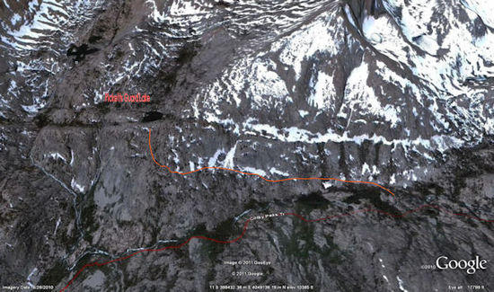
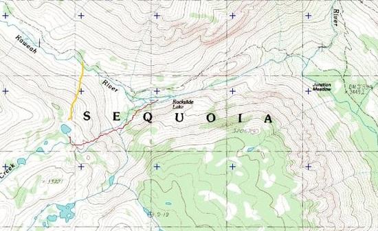
    Now I know exactly what lake you are referring to. It is the last in a chain of 3 lakes that are connected and sourced by Pickett Guard Creek. It flows into the last lake from roughly the south and empties down a cliff and continues on to the Kern Kaweah River roughly from the east, so they are separated by approximately 90 degrees. I exited the Kaweah Basin via the route you refer to two years ago and the route is considerably different from the info you have. Basically, you drop over the rim that separates the lake from the slope leading roughly north down to the Kern Kaweah River. From there descend contouring westerly around the nose of a ridge that borders the lake on the west and look for a cluster of fairly large pine trees. Be careful not to drop too low, or you will be in for a very steep rough descent to the river. There is a small cairn there which will tell you you have found the start of the route. At least it was there 2 years ago. In any case, at that point, the route will be obvious. From that point on follow the seam in granite slabs WNW and descend to the Kern Kaweah River, which you will reach about 1/2-3/4 mile west of Rockslide Lake. To ascend, reverse the route I have described, but you will have to evaluate the granite slabs you will be ascending very carefully to find the start. Look for occasional trees that, if connected by a line, would delineate a rising traverse. It may take a little time, but is quite doable.

    Another route, one I prefer for its aesthetic qualities and micro rout finding problems, is to cross the Kern Kaweah River just above Rockslide Lake. The river divides into 2 channels there. Follow the southern most channel until you come to the end of the large talus slope on the southern bank, then cross and ascend along a wall on your left. Eventually you will come to a rock filled notch which you will climb up through and turn right, following a shallow level gully until you come to Pickett Guard Creek. Follow it on up, without crossing, and take the unnamed east fork of Pickett Guard Creek until you come to a small lake, more like a pond actually, cross the log jam at the outlet, and contour around it on the right and ascend slabs about 700-800' up into the east arm of Kaweah Basin. Camp at the first lake, which has excellent campsites either on flat granite or back in a grove of pine trees. There are excellent views of the Kaweah Peaks Ridge there and it is by far the prettiest part of Kaweah Basin. From there it is easy to cross a low saddle on the ridge that separates the 2 arms of the basin and follow Pickett Guard Creek down along the 3 lakes to the descent route described above. Either way, you are going into my candidate for the most beautiful spot in the Sierra. Whichever way you choose to enter and exit, it will be worth the effort.

    Just for the heck of it, I've included a link to a trip report I posted for a trip into the Kaweah Basin in 2009. If you're interested, it will give you an idea of what the place is like and also some narrative of the route finding involved.

    http://www.backpackinglight.com/cgi-bin/backpackinglight/xdpy/forum_thread/25394/index.html

    "The passes over the Kings Kern divide concern me for the same reasons you mentioned….lots of loose Talus on the hard northern or western sides which I plan to descend and it's always harder to climb down. I've read cautionary tales about Lucy's Milly's and Harrison with the looseness of Lucy's getting special cautionary mention and of course the top of Millys is class 3 and loose."

    I think Harrison is by far the better choice of the 3 if you want to exit via East Lake and Junction Meadow(Bubbs Creek version). It is large blocky talus with very little loose rock. There are a couple of awkward moves at the very top, but after that it is basically a talus hop. Once at the bottom of the chute, it is a very pleasant hike down to East Lake. If you prefer a bit more off trail exposure and an exit via the beautiful Sphinx Lakes Basin, Thunder Col is also a good choice, although a bit more sketchy than Harrison. Still, it is safer than either Milly's or Lucy's for a descent, and the route from there is a lot of fun. Just ascending the wide basin beneath Thunder Mtn from the unnamed 3 bay lake to get to Thunder Col is a rare treat. I think this is the lake the guy in your link refers to as Ghost Lake. The creek in the basin, which I call Thunder Basin, has 4 exquisite waterfalls and the scenery is stunning.

    http://www.backpackinglight.com/cgi-bin/backpackinglight/xdpy/forum_thread/25394/index.html

    "The So-called Little Joe has been mentioned by a couple of sources as the least loose and basically class 2. Maybe you could look at the photos about 4/5th of the way down the page on this link (with nice shots further up of the upper Kern!) and venture your understandably qualified opinion."

    From the pictures it does look a whole lot easier than either Mily's or Lucy's. As you said, basically class 2. If I ever decide to head in that direction again, I will definitely check it out. That is unlikely, however, as I found the area north of the Kings Kern Divide to be far too over populated with both people and their inevitable shadows, the black bears. I have since found myself spending more and more time exploring the nooks and crannies along The Great Western Divide, or just hanging out in the Upper Kern Basin. Funny thing about Harrison Pass: I have crossed it from south to north 3 times and never found any snow worth mentioning, but that was back in the late 70's-early 80's. Maybe things have changed since then, or maybe I just got lucky.

    #1753431
    obx hiker
    BPL Member

    @obxer

    Tom,

    Thanks for the good info on the route up to Picketts Guard Lake.

    "Basically, you drop over the rim that separates the lake from the slope leading roughly north down to the Kern Kaweah River. From there descend contouring westerly around the nose of a ridge that borders the lake on the west and look for a cluster of fairly large pine trees. Be careful not to drop too low, or you will be in for a very steep rough descent to the river. There is a small cairn there which will tell you you have found the start of the route. At least it was there 2 years ago. In any case, at that point, the route will be obvious. From that point on follow the seam in granite slabs WNW and descend to the Kern Kaweah River, which you will reach about 1/2-3/4 mile west of Rockslide Lake."

    It's so difficult to communicate 3 dimensions in writing but your description matches what I thought was the route only I was sketchily describing it in reverse from the bottom up:

    "I've read that the access is to slab SE up the steep slope from around Rockslide lake."

    You can pick out the route looking at it carefully in Google Earth; though on the other hand I never trust the perception of slope you get from that.route to picketts guard lake

    Does that look about right? Your second route is basically going up the stream. I think I read your trip report before on that one but look forward to going over it again later today.

    The notes on Harrison and Thunder pass are very helpful. That basin leading up to Thunder pass; I thinks it's Table Creek, looks beautiful and the uppermost lake is evidently one of the few above 12000. Everything I've read about Thunder prescribes an ice ax and crampons; and my limited experience does include a few steep snowfields late in the season melted down to nothing but ice…..yikes! (even with crampons and ice ax..) So I was a little hesitant on crossing that one but I do plan to cross Longley after crossing the Kings/Kern divide by whichever route. I'm planning my trip for the second week in Sept. Guess I can see how it goes and decide if I want to try Thunder Pass. I was already planning to camp at the "three Bay Lake" and go up that basin a ways as that stream and the waterfalls look beautiful; which is why btw I asked about McLeod. Your info re: Thunder is encouraging! I think ghost lake is about half way towards lake south america from 3 bay. I too want to avoid the Eliz Lake and Bubbs areas for exactly the reasons you mentioned though I plan to haul along a bearcan. I also plan to come in and go back out via sugarloaf and Marvins which means going down Brewer Creek so I'll miss the Sphinx Lakes ( so near..) but that basin does look beautiful

    Thanks again for the good info….decisions decisions hmmmm. Got any more good ideas/advice?

    #1753561
    Anonymous
    Inactive

    "You can pick out the route looking at it carefully in Google Earth; though on the other hand I never trust the perception of slope you get from that.

    Does that look about right?"

    Cola,

    That's the route alright. Spot on.

    "Your second route is basically going up the stream."

    Yes, but you want to be sure to follow the eastern unnamed fork of Pickett Creek. If you decide to go that way, don't cross over and try to follow the named branch up to that last lake before the descent by the other route. I've read, and it looks from personal observation, like some serious scrambling, possibly class 4.

    "I also plan to come in and go back out via sugarloaf and Marvins which means going down Brewer Creek so I'll miss the Sphinx Lakes ( so near..) but that basin does look beautiful"

    You can save that for another time. I mention it only because it is a very scenic way to exit. However, it has long since been discovered and now has bear problems. I quit visiting it around 1982. I wouldn't make it a destination, if I were you. Too bad; it used to offer very good fishing, solitude, and a very scenic place to hang out for a few days.

    "Thanks again for the good info….decisions decisions hmmmm. Got any more good ideas/advice?"

    I'm not familiar with either Sugarload or Marvins, but I gather you will be coming into the Kern Basin over the Kings Kern Divide and proceeding down Kern Canyon to Junction Meadow before going up the Colby Pass Trail to access Kaweah Basin. If this assumption is correct, I would suggest considering entering Kaweah Basin via the Pickett Creek route I described, then exiting via the route shown on Google Earth that we have discussed. From there, continue on up the Colby Pass Trail until you are just below Milestone Bowl, turn north and ascend through Milestone Bowl, cross Milestone Pass, and drop down into Milestone Basin. From there you can access The Upper Kern Basin again via an absolutely gorgeous route and continue on your exit route. Milestone Basin is special, trust me on this. This suggestion has 3 advantages: It will take you through more of Kaweah Basin and familiarize you with 2 entry/exit routes for Kaweah Basin; it will take you through even more very scenic country; it will avoid dropping back down into Kern Canyon and doing the tedious ascent back up to the Upper Kern Basin. There is not much to recommend it, IMO. If you read that trip report, you will have a much better idea of what I am talking about here.

    That's about it for now. As you said, decisions, decisions, but I have to say it's not a bad problem to wrestle with. ;)

    #1753692
    obx hiker
    BPL Member

    @obxer

    Yes I've looked hard at Milestone. I'm coming in past Roaring River and up Cloud Canyon and over Colby. I fly into San Jose and drive to Horse collar? by Marvin Pass for the first day, then to @ Roaring River,then Colby Lake. At first I was planning to start at Roads End but sleeping the first night at @ 5000 then climbing 5K over Avalanche pass at +10K the first day when the total mileage saved is a mile or 2 didn't seem like the best idea. The Marvin Pass route is realatively level and gives time for a gradual acclimatization to the altitude and a more gradual climb to break the old legs in. Also I really want to stick my nose into the lower Kaweah Basin hence checking out that route to Picketts Guard Lake.

    Looking at the map it appears the milestone outlet is just above Gallats so that might be a great alternative to going down to the junction and up along the Kern. Might even be shorter distance wise but of course overland is almost always harder. Got any good "beta" on going up Milestone Bowl?

    #1753833
    Anonymous
    Inactive

    "Got any good "beta" on going up Milestone Bowl?"

    Yes. I've been in Milestone Bowl 4 times, twice from the north and twice from the south, either coming or going on other trips. If you decide to go into the Kern Basin via The Bowl, you'll be coming from the south, off the Colby Pass Trail. You'll actually leave the trail a couple miles farther west than Gallats Lake. As you come off the second set of steep, dusty switchbacks that take you up out of the Kern Kaweah River Valley, you will emerge into a high valley just below Colby Pass. There is a stream coming down out of The Bowl, about 1/2 mile east of Colby Pass, which you can follow up to a couple of very small lakes with excellent campsites. From there, probably the easiest way for you to proceed is to follow the stream up into The Bowl proper. Once there, I have found it easiest to stay to the left and ascend a series of sandy benches interspersed with short stretches of talus until about 200 vertical feet or so below the pass. You will be zig zagging back and forth and it will take a little longer, but it is easier on "old legs". Then you will have to go on talus completely up to the actual pass. You can also go straight up the center of The Bowl, but you will have to deal with more talus. At all costs avoid the right side, where you will encounter huge blocks of talus early on, and it makes for a very tiring ascent. The pass itself is to the left of center on the saddle. You will have to hunt a bit, but it is easy to recognize. It is to the left of a couple of short, jagged pinnacles, and is high class2/low class 3 for about 15 feet or so and then just a long slog down an endless talus slope until you hit granite slabs along the headwaters of Milestone Creek. The better campsites are down lower where the gradient eases off and the stream begins its meander down through Milestone Basin. There you will find a lot of flat benches, either grassy or sandy, along the stream. It is a truly idyllic hike from there to the Kern Basin.

    The only downside to this route is that you will have to backtrack about 6 miles on the Colby Pass Trail once you come down from Kaweah Basin, but I can assure you it is a far more beautiful, and challenging, route into the Kern than dropping down into the Kern Canyon. Even with the backtracking, I doubt it is much further than going down into the Kern Canyon, maybe 2-3 miles.

    Given that you are starting from the west side, I think you made a good call on your approach route. The trail from Bubbs Creek up to Avalanche Pass is a bit of a slog, and 5000' on your first real day of hiking would likely have you feeling it by day's end. Not the best way to start a trip as demanding as this one.

    #1879043
    Brett Watson
    Spectator

    @4x4dragon

    Hey Tom,

    any information on Picket Guard Lake from a more easterly approach? I've got a trip started for mid august and I'm really wanting to get to Picket Guard Lake. Flying into Vegas so i'm limited to eastern trailheads like Cottonwood Lakes/Cottonwood pass.

    thanks

    #1879064
    Adan Lopez
    Spectator

    @lopez

    Locale: San Gabriel Valley

    Yall got me thinking. thanks!

    #1879111
    Anonymous
    Inactive

    "any information on Picket Guard Lake from a more easterly approach? I've got a trip started for mid august and I'm really wanting to get to Picket Guard Lake. Flying into Vegas so i'm limited to eastern trailheads like Cottonwood Lakes/Cottonwood pass."

    Hi Brett,

    If you're coming in over Cottonwood Pass, I assume you'll also go over Crabtree Pass and on down the Crabtree Laks chain to hook up with the JMT. From there to the Wallace Creek junction, down the HST to Junction Meadow in Kern Canyon, and on up the Colby Pass trail to Rockslide Lake. I am assuming all of this because I don't know of any direct east side route into Kaweah Basin that don't involve scaling the west wall of Kern Canyon, which is eminently possible but would require some serious scrambling skills, probably class 4/low class 5 depending on which line you chose. I think your best bet would be the route up the unnamed east fork of Pickett Creek discussed above. It comes in from the northeast. Other than that and the other route discussed above, all other routes in the class 2/3 category involve approaches from the west or south sides of Kaweah Basin. If you're coming in via Cottonwood Pass, these routes would involve a substantial detour, chewing up a day or two to no advantage that I can see. Take a look at the map and see what you think. We can discuss it further then, if you'd like.

    Tom

    #1879121
    Dave T
    Member

    @davet

    Loving this thread too. Making my mind wander.

    #1879147
    Aaron Sorensen
    BPL Member

    @awsorensen

    Locale: South of Forester Pass

    I've been up both Colby and the East side of Brewer. I've been almost everywhere you guys have been mentioning.
    Going up Colby from the west is much easier. Brewer is not all that hard, but looks deceivingly difficult from a distance.
    Everything here is great. I personally like being North of Forrester or West of the Kern and South of Lake South America.
    I guess the huge basin South of Forrester is just unappealing to me.

    I would suggest new army over to Whaleback and dig your way to Lake South America to Miley's then Brewer and back around over Colby.
    I've done a lot of this and they seem to be the areas with the best views, (in the southern area anyway).

    #1879383
    Nathan Hays
    Member

    @oroambulant

    Locale: San Francisco

    Been to Reflection and Vidette, never south of the divide. Will be there twice this summer. Can't wait!

    #1880075
    Brett Watson
    Spectator

    @4x4dragon

    Possible lines up to Picket Guard Lake from Colby Pass Trail

    Hopefully I uploaded the photo correctly showing in RED what i believe your suggested line up to be and then another line in orange per suggestion of another trip report.

    Ultimately your assumptions are correct althought my first impulse was just to stay on the PCT all the way up to Wallace Creek……… but i did like the idea of cutting through Miter Basin and over Crabtree Pass and then down. Wouldn't the route through Miter Basin take a little longer/more elevation? Also, i found some mileages that I would like for you to confirm. I'm showing Rockslide Lake as about 1.5 miles from Junction meadow so would that make Picket Guard Lake around 2-2.5?

    In and ideal world our hike will go like this:

    Horseshoe Meadows up to Cottonwood Pass with an offtrail scramble just past Chicken Spring lake up to Cirque Peak and then along the spine to New Army Pass and then dropping down to Soldier Lake for camp#1(or a tad further into Miter… contingent upon a side trip up Langley) Day 2 push through Miter Basin and on up to Crabtree Pass and then down to Crabtree Meadow for camp #2. Day 3 push on through to Wallace Creek, down through Junction meadow and up to Picket Guard Lake. Maybe 1 rest day at Picket Guard and then head back to Horseshoe OR Cottonwood Lakes trail to round out the last few days.

    ALTERNATE: Take the PCT all the way to Wallace and then to Picket Guard Lake and on the return go through Miter Basin etc… to maybe allow for some time in the Miter Basin.

Viewing 25 posts - 1 through 25 (of 27 total)
  • You must be logged in to reply to this topic.
Forum Posting

A Membership is required to post in the forums. Login or become a member to post in the member forums!

Get the Newsletter

Get our free Handbook and Receive our weekly newsletter to see what's new at Backpacking Light!

Gear Research & Discovery Tools


Loading...