Topic
PCT Water Mexican Border to Cibbets Flat CG
Forum Posting
A Membership is required to post in the forums. Login or become a member to post in the member forums!
Home › Forums › General Forums › General Lightweight Backpacking Discussion › PCT Water Mexican Border to Cibbets Flat CG
- This topic is empty.
-
AuthorPosts
-
Jun 16, 2011 at 5:24 pm #1275542
Anyone out here do this regularly / lately? I'm thinking about doing 30 miles or so next weekend but it's gonna be hot and I don't know about water source availability… by so cal people here?
Jun 16, 2011 at 6:28 pm #1750168Check this out: http://www.4jeffrey.net/pct/a.htm
Jun 16, 2011 at 8:12 pm #1750211here are some comments on the water link provided.
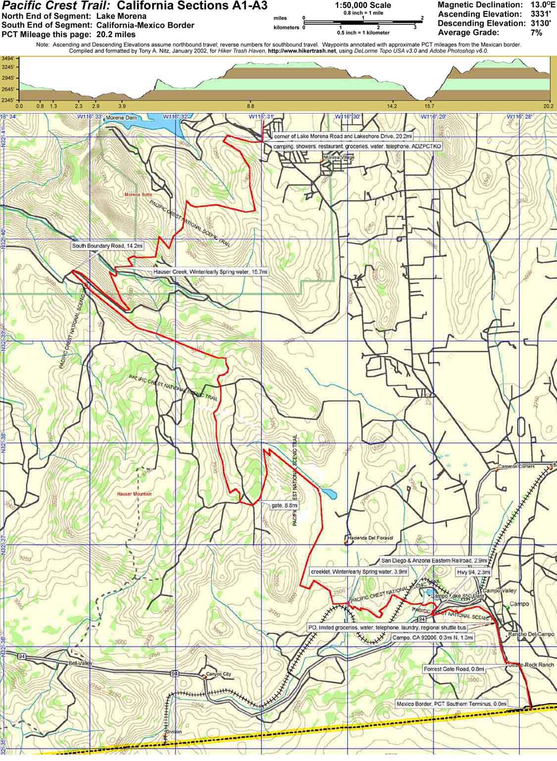
I am from the area and regularly trail run on the Lake Morena to Cibbets section.Border to Lake Morena
this is cattle grazing country, and illegal allien country, with all their issues. you will want a top quality filter to use any available water. haven't been there this season to see water flow for myself.Lake Morena
a small village. great place for some ice cream.
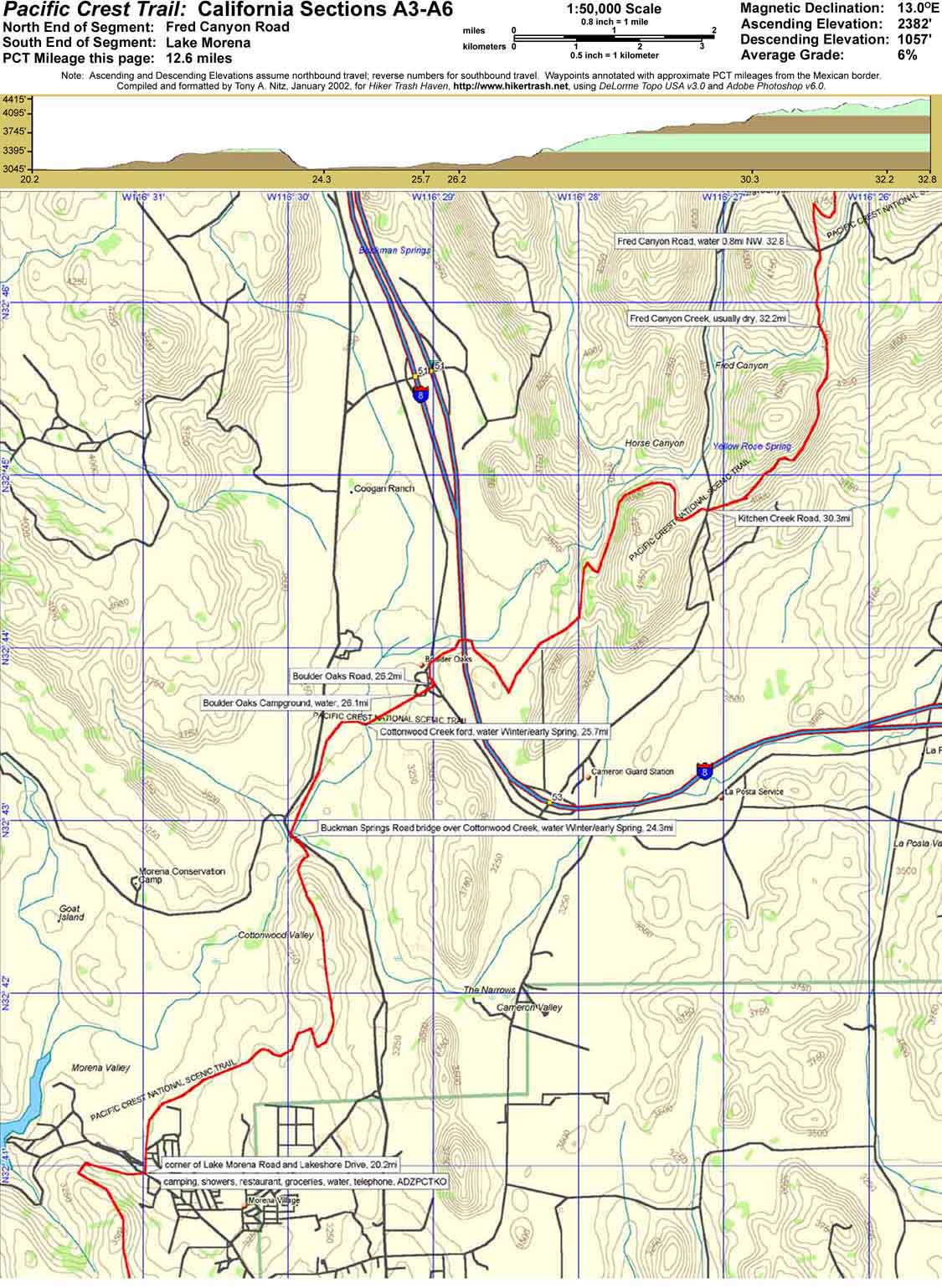
no water sources I am aware of between Lake Morena and Boulder Oaks, at least none that I would use.Boulder Oaks Campground
tank up on water here and go all the way to Cibbets (only 8 miles or so).
I think the Toad mating season is over and the campground should be open again.Kitchen Creek
the PCT trail is very high above the creek. requires a steep descent and then ascent to get water.Fred Canyon Creek
this is essentially dry now. only another 1.5 miles to Cibbets though.Cibbets Flat Campground
plenty of spigot water. nice campground that rarely fills up.Jun 16, 2011 at 10:05 pm #1750247Thanks Scott and Art! I've checked that list and the PCT L water source list but it hasn't been updated in the last month…. So… Was looking for some real recent realtime beta. Great info Art. I'm sure there's enough water to get by on right now, just debating my trip destination to cash in my hall pass… Thanks again for taking the time.
Jun 16, 2011 at 10:53 pm #1750253Last week I was near Campo Creek and still heard water flowing, but did not actually see it. Plenty of water in Cottonwood Creek which you will cross twice before Boulder Oaks. Judging by the water in Cottowood, Kitchen Creek should still have enough water(it feeds into Cottonwood). Hauser should still have plenty of water, Lake Morena Dam leaks like a sieve. I'll try and take a drive up Kitchen Creek tomorrow and have a look. Get back to you tomorrow. Depending on your schedule you should be able to find enough water.
I hike from my house to Lake Morena County Park(1 mile) and up to Kitchen Creek Rd. in about four to five hours alot. If you plan on staying near Lake Morena first night, you can get most the next section done before it heats up.
Jun 17, 2011 at 7:36 am #1750312Thanks Chad! I've been wanting to start section hiking the PCT and never find the right few days but it looks like this weekend is gonna be it! I'm anal and want to start at the beginning. I know it'll be pretty hot and require more water so I was really worries those water sources would be dried up….I think it's supposed to be in the 90s….but I have a solar umbrella and lots of patience…
Jun 17, 2011 at 8:27 am #1750321Edward how many days do you plan to take hiking, 2 ? , 3 ?
its 34 miles from border to Cibbets Campground.
I'm sure you know Cibbets is not right on the PCT, its 3/4 mile down Fred Canyon Rd from the PCT.Have you seen these maps ?
.
Jun 17, 2011 at 10:38 am #1750369I went up Kitchen creek and it still has plenty of water. Boulder Oaks is still closed. Cottonwood still has plenty of water, but the warm temps have grown alot of algae. I would drink it no problem as long as treated. I think your only concearn will be from border to Lake Morena. I would bet Hauser has water, as most seasonal creeks are still flowing. Temps in Lake Morena have been in mid 80's. Last week we had lows in the 30's, so make sure to check overnight lows for the weekend. Wunderground is usually accurate and has local weather station info.
Jun 17, 2011 at 3:29 pm #1750477Thanks so much! I'm doing it. Obliged. Art thanks I have three days for the hike. Starring sat am and exiting mon afternoon…. Thanks for the maps…. I also have it uploaded to my Garmin Oregon but not sure I'll need it. Thanks
-
AuthorPosts
- You must be logged in to reply to this topic.
Forum Posting
A Membership is required to post in the forums. Login or become a member to post in the member forums!
Our Community Posts are Moderated
Backpacking Light community posts are moderated and here to foster helpful and positive discussions about lightweight backpacking. Please be mindful of our values and boundaries and review our Community Guidelines prior to posting.
Get the Newsletter
Gear Research & Discovery Tools
- Browse our curated Gear Shop
- See the latest Gear Deals and Sales
- Our Recommendations
- Search for Gear on Sale with the Gear Finder
- Used Gear Swap
- Member Gear Reviews and BPL Gear Review Articles
- Browse by Gear Type or Brand.
