Topic

Glacier Peak Wilderness


Forum Posting

A Membership is required to post in the forums. Login or become a member to post in the member forums!

  • This topic is empty.
Viewing 14 posts - 1 through 14 (of 14 total)
  • Author
    Posts
  • #1272114
    Paul Bright
    Member

    @hikenc

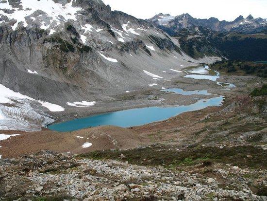
    I’m planning a trip somewhere outside of Seattle at the end of July and Glacier Peak wilderness is at the top of my list. I’m looking for a 30-40 mile hike to do in 3 days or so. I think a loop would probably be the best just so I can see as much as possible. Hiking above tree line and camping at small alpine lakes with opportunities to bag some peaks are some of the things I’m looking for; and solitude! The PCT seems like a good option, but it seems as though there is more access to alpine lakes east of the PCT. Does anyone have any suggestions? If there are some amazing areas adjacent to Glacier Peak that would be fine as well, Alpine Lakes Wilderness or maybe North Cascades NP.

    Thanks

    Just curious, does anyone know if there are any kml or kmz files of the trails in these wilderness areas?

    #1723637
    K. S.
    Member

    @bwalt822

    Do a google search for "copper ridge loop north cascades". Its 34 miles long and has 10k ft of elevation change. There are opportunities for bagging Hannegan and Ruth peaks which both have some of the best scenery I have seen up here. Half of the loop is a ridge the other half a valley. Also one of the creek crossings is very interesting, you cross by sitting on a suspended cable car and pulling yourself across.

    #1723660
    Jake Palmer
    BPL Member

    @jakep_82

    Locale: Pacific Northwest

    I did Spider Gap loop last September. I'm not sure about peaks, but it was a great trip with some nice lakes along the way. The link below is pretty close to the route we took.

    http://www.dailyhiker.com/news/spider-gap-loop/

    Here's a picture I took of Lyman Lakes after crossing over the glacier.

    Lyman Lakes

    #1723664
    Mary D
    BPL Member

    @hikinggranny

    Locale: Gateway to Columbia River Gorge

    Jake's trip is part of an extended loop that starts with Spider Meadow, goes over Spider Gap (not really a glacier but a snowfield) to Lyman Lakes, then to Image Lake, then to Buck Creek Pass and back to within a couple of miles of the Spider Meadow trailhead. Glacier Peak is close-up and awesome for a good part of the trip. IMHO, it's one of the most beautiful trips in the whole North Cascades.

    You'll find a good writeup in Doug Lorain's "Backpacking Washington," which describes a number of other great backpacks in Washington. You'll also find a number of trip reports–with lots of pictures–on the Seattle-area forum, http://www.nwhikers.net. That was the only trip I ever went on in which I left the camera home to save weight. Never again–I now consider my camera one of the essentials!

    #1723680
    Paul Bright
    Member

    @hikenc

    The Cooper Ridge Loop sounds like a good fit. I'll try and find the loop and compare on google earth. It seems like there are great opportunities to climb some peaks; the creek crossing seems cool too.

    I didn't know the name of the loop, but Spider Gap loop was a trail I was looking at from the trails illustrated map. It's good to know the trail continues over the pass to Lyman Lakes. Is it okay to cross passes to connect trails even though they not marked on the map? That might open some possiblities for me. Seems like a great loop for sure! I might have to check out that book Mary. Do you recomend any other books for the area?

    Has anyone hiked the Devil's Dome Loop? I just saw that on the NP website. How crowded does the actually National Park get in the summer? Maybe it would be better to stay below the park? Not sure.

    #1723692
    Mary D
    BPL Member

    @hikinggranny

    Locale: Gateway to Columbia River Gorge

    Most of the guidebooks for WA (the best known of which are published by the Mountaineers) are day-hiking books. Much of the Mountaineers books have been incorporated into the trail descriptions on the Washington Trails Association website, http://www.wta.org.

    The one caveat on the Spider Gap to Lyman Lakes route is the long snowfield you need to descend. It's a good idea to wait until the snow is mushy, say mid-afternoon. On a cold morning, an ice axe would be needed. I had no problems at all using a single hiking stick on a fairly warm afternoon. EDIT, later: I didn't try to glissade; I plunge-stepped down.

    Most of the Devil's Dome loop is in national forest land (Pasayten Wilderness). It's only the section along Ross Lake (East Bank Trail) that requires camping permits, and that will be crowded because of the boat traffic. Ross Lake is actually in the National Recreation Area rather than the N. Cascades NP, but the same rules apply as in the NP except that hunting, dogs and power boats are allowed.

    Note that out here in the Northwest, most USFS trailheads require a parking permit, called the NW Forest Pass. It's $5/day or $30/year, and is to be hung from your rearview mirror while your vehicle is parked. You'll have to check to see if it's required at the specific trailhead you'll be using.

    #1723902
    Dirk Rabdau
    Member

    @dirk9827

    Locale: Pacific Northwest

    While I wholeheartedly endorse the suggestions of Mary, Bill and Jake, both hikes are among the more popular routes you can take – that's not to say it's crowded, not at all…but you will see folks. If you go off-trail, you likely won't see many people at all. But even with the people, these trips have some climbs, so the people you meet will generally be enthusiastic backpackers.
    I would say that the Glacier Peak Region north is perhaps my favorite stretch of trail in Washington – if not at the top it ranks dang close. The Glacier Peak, Pasayten and North Cascades all hold a great appeal. If you ever have the time, just hiking along the PCT north through these wildernesses is enthralling, especially in late summer and early fall.

    Dirk

    #1723961
    Paul Bright
    Member

    @hikenc

    Thanks for the website and the tip about the parking permits.

    We plan on doing two, three day trips while we’re there. Definitely one will be in Glacier Peak and I’m considering Alpine Lakes area as the second. Anything special I should know about this area? It seems as though it would be best to stay away from the southwestern section due to the ski area; I think there is one near the northern boundary too. Is this a well traveled area?

    #1723970
    Marc Shea
    BPL Member

    @flytepacker

    Locale: Cascades

    You can find solitude in the Alpine Lakes wilderness, however, on weekends most of the trails are crawling with throngs of people. Just anticipate the first few miles of trail or so will have people on them, especially at the tail end of July. The PCT from Snoqualmie Pass to Stevens Pass covers some beautiful country, and true to the name, you will have plenty of lakes to visit along the route.

    #1724013
    Paul Bright
    Member

    @hikenc

    Would I need a bear canister in these areas?

    #1724061
    Jake Palmer
    BPL Member

    @jakep_82

    Locale: Pacific Northwest

    I've done the Spider Gap trip I mentioned and the Enchanment Lakes in 2009. On both trips we just hung our food and had no problems with bears. I did have a mouse chew through a bag of trail mix, but that was my fault for leaving it on the ground unattended while I was cooking.

    #1724668
    Paul Bright
    Member

    @hikenc

    Jake,

    I have a friend going with me out West and I wanted to show him some of the loops I'm thinking about. Do you have one other picture you could post so I could share with him? Also, how long was this loop?

    Thanks!

    #1724700
    Chris Morgan
    BPL Member

    @chrismorgan

    Locale: Southern Oregon

    Just an FYI, according to the WTA (Washington Trails Association) blog, western roads leading to GPW will be closed all summer long for construction – looks like you need to use the east side, which may limit access:

    http://www.wta.org/trail-news/signpost/road-closures-on-the-mbs

    (which probably means more secluded, but shhhhh!, don't tell anyone!)

    #1724827
    Paul Bright
    Member

    @hikenc

    thanks for the tip. this will be very helpful when planning our trip.

Viewing 14 posts - 1 through 14 (of 14 total)
  • You must be logged in to reply to this topic.
Forum Posting

A Membership is required to post in the forums. Login or become a member to post in the member forums!

Get the Newsletter

Get our free Handbook and Receive our weekly newsletter to see what's new at Backpacking Light!

Gear Research & Discovery Tools


Loading...