What follows is an account of an unsuccessful solo day trip, probably the most fouled up trip I have ever taken. I enjoyed it thoroughly.
"You've got to be very careful if you don't know where you're going, because you might not get there." – Yogi Berra
Prelude
On Saturday, May 15 my wife and I traveled from Michigan to the Phoenix area to see our first granddaughter. She's an angel. I was determined to take a day-hike sometime during the week and so acclimatized to the heat with a 2 hour up-and-down of Camelback Mountain [pic] (where I'm told I just missed a trailside rattlesnake), butte scrambles and jogging in Papago Park and 18 holes of golf.
A BPL member graciously offered some day-trip suggestions and directed me to hikearizona.com to get details. A hike up Battleship Mountain in the Superstition Mountain range had the right ring to it; a smallish peak with a tricky approach. I planned to find trip details online and to purchase a map when in the area.
Funny thing about Time, it drags on then races along. It really is relative. Baby kept us busy and happy as clams. There were trips to the grocery store, hardware store and dog park, euchre, morning coffee on the patio, cold beer poolside and evening strolls. Life was good … but suddenly it was Tuesday. Wednesday's forecast called for 92F; after that it was going to get hot. I had done exactly zero research. So Tuesday night I downloaded a trip report that included photos of the ascent route. This is where things began to go wrong. I could not locate a decent on-line map. But no worries, one must be available in Apache Junction. I planned for an early start.
The Trip
Wednesday at 6 am I packed a book bag with 1L Gatorade, 2.5L water, trip report, Droid, light snacks, shades, runners cap and suntan lotion. I had set out running shorts, golf anklets, Inov-8 330's, a wicking T and a compass and was ready to roll.
Baby woke crying and who could resist giving her a bottle? Did I mention she's an angel? At 7 am, with a promise to be back by 6 pm for flatiron-cilantro tacos in authentic tortillas (I'm not missing that) and marguerites (Cazadores, agave nectar and squeezed lime) I finally departed. Next stop – Apache Junction QuikMart. 8 am. No maps and no idea where to get them. Oh well, there will be trail maps at the trailhead.
Of course at the First Water trailhead there were no maps and no map board. Also, I had left my compass home. Hmmm. I do have a trip report. I fired up the Droid to take a compass reading, noting the general direction of obvious landmarks including a very cool spire. I didn't know if the Droid compass would operate in the more remote areas so I shut it off to save the battery.
The trail was broad. The weather was fine. It was 8:30 am; late.
Knowing I was an under-prepared stranger in a strange land I determined to keep from being a poster child for SAR: pay attention to landmarks and look back often, monitor my water supply and response to the heat, never lose track of the trail, always know the way back and take no undue risks. I didn't want anyone worrying (and didn't want to miss the tacos) so I needed to be out by 5 pm at the latest. Onward.
The downloaded trip report says to take First Water Trail to Second Water Trail to Boulder Creek Trail. Distance not specified. Second Water proved to be a short distance away and easy to follow. The landscape was alien to me; mountains, ridgelines, gullies and the not-at-all-barren high desert flora. There were a few lizard species including "horny toads", a small translucent scorpion (very cool) and birds large and small. The first time I flushed a couple of doves I about jumped out of my skin. There were small flies and a few mosquitoes, but no biters and easily ignored. The blue sky was stunning.
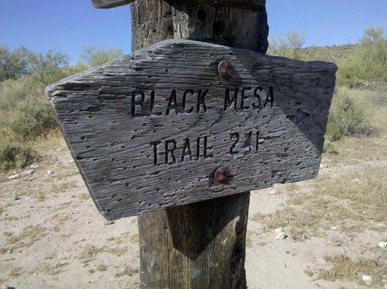
I made very good time, sidewalk time. Down a couple of creek beds then up onto a flat expanse. At about 1.5 miles is a crossroads where the Second Water Trail signpost points left. Black Mesa Trail also points left. Hmmm. And what is this Black Mesa Trail anyway? I could have kicked myself for not arranging a map. At that point I made a good decision; go back to the parking lot and find someone that knows the area or has a map.
The walk out was a little bit of a downer but back at the lot were 3 day hikers with a topo map. OK! Now I had a clearer picture. At the confusing junction the map shows that Second Water goes left, Black Mesa goes right (why did the sign point left?). Both connect to Boulder Canyon Trail forming a big loop. Black Mesa is the much longer route so I aimed to stay with Second Water Trail which virtually dead ends into a massive and sheer mound; Battleship Mountain! "Hmmm". Battleship looked larger on the map than the trip report photos would have suggested.
"Thanks gentlemen."
"You're welcome and watch out for rattlesnakes. You missed one 50 feet back across the lot." Why do people keep saying that?
With a much clearer notion of where I was headed I set out again. Back at the junction a closer look at the Black Mesa Trail sign showed a tiny etched arrow pointing…right. The big wedge shape on the left edge of the signpost looks like a big arrow to me but is really just a "nice" design.
Now confident and still with plenty of time I marched on. Through a flat grove-like plain, over an ankle-twisting rocky section and, after a couple of miles, the trail descends a few hundred feet to Boulder Canyon. On the descent I met the first of two hikers I would see on the trail. We stopped for a brief chat. He related a legend of a hidden Spanish treasure map up on Battleship Mt. I would trade it for a common everyday topo map because I was still concerned about locating the only approach to the summit.
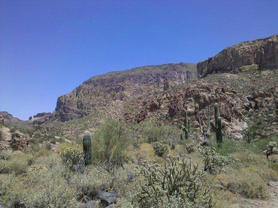
A minute later then directly ahead, bigger than life, was Battleship Mountain. Just as the map had indicated. And BIG. Bigger than I would have thought. Hmmm. Didn't really look like the pictures. But it was long and narrow, like the photos. Certainly when I see it from the approach…
Continuing to the canyon floor there was a surprising amount of water, lots of trees, shrubs, grass and probably rattlesnakes. I sure wish no one had mentioned rattlesnakes. Paranoid, I grabbed a stick and prodded my way through the grasses. That lasted for 5 minutes until I got a grip.
At the terminus of Second Water Trail the intersecting Boulder Canyon Trail went left and right. Battleship to left was a sheer cliff. To the right it tapered down, just like the description. Problem was, there was a very steep ridge between me and any approach. I would have to follow Boulder Canyon to the right to circumvent the ridge.
Boulder Canyon makes for a great walk. The creek bed was mostly dry, the trail is narrow, less traveled and can be difficult to follow at bed crossings. At one point I found clear water running between pools. With tadpoles. I still had plenty of water but a good cool-down was in order. I peeled off my shirt, dipped it in a pool and put it back on. Same with the hat. Chilling. I stayed quite cool for the next half hour. Back on the trail I was introduced to the appropriately-named Cat's Claw shrub.
A couple of miles up Boulder Canyon the offending ridge tapered down. I crossed the creek and picked a route up the low flank of Battleship Mountain. This was hard work. All up, no trail, boulders and rocks and lots of sharp things. Thirty minutes of this and it became very apparent that I would not be able to summit and return in time. A slam-dunk no-brainer. Time to turn around. I could say I was disappointed but from the minute I saw the mountain and the blocking ridge things had not looked promising.
Back at the creek bed I decided to continue on up the canyon and try to hook up with Black Mesa Trail to complete the loop. With only a vague sense of the distance to BMT I set a time limit for turning around. If at 2:00 I did not find the trail fork I would have to retrace my steps. 2:00 came but not the fork, so knowing I was probably walking away from the shortest route home, I turned around to re-trace my steps. Heading back defeated I was still very content passing through the deep canyon along the creek bed in peace and quiet. On the way I bothered an eagle that I did not recognize, dark brown with a broad white tail band; an immature golden eagle as it turns out. At the clear pools I again cooled down and filled two empty bottles "just in case".
Back at the junction with Second Water Trail I was about to make my turn for home when directly ahead I spotted what was very clearly my goal; the correct (and possibly misnamed) Battleship Mountain. A lone peak in a low valley. Just like the photos. I literally stopped in my tracks. "SON…OF…A…B****" I yelled. With no time to do anything but walk out, I turned up Second Water Trail for home. Two steps later I saw the second hiker of the day, a lone female backpacker, at a dead stop and on high alert. She sensed a lunatic. After reassuring her that I was no threat I headed for home. Back across the "snake infested" grasses, a long slog up out of the canyon and 3 miles or so back to the car. I had time to think.
Some lessons
What did I do wrong? No map, no map, no map. The late start didn't help nor did forgetting the compass. No one else got the memo about wearing thin shorts and shirtsleeves. Everyone I met wore long pants and shirt, big hat and solid boots. Frankly, my clothing choice worked fine for me other than scratches and a collection of needles and burrs in my socks and shoes.
What went right? Well, I came first and foremost to enjoy the hike and exert myself and that I did. It was a memorable walk in spectacular country. I was pleasantly sore after roughly 16 miles in 8 hours. Setting a time limit and sticking to it got me home on time. And though I didn't really know where I was going, I was never lost. Sun tan lotion, lots of fluids and cooling off when I got the chance kept me comfortable. And somehow I managed against all odds not to fall victim to a host of rattlers like the cowhand in Lonesome Dove.
Next time I'll probably wear long pants. Next time when my inner self says "hmmm", I'll pay more attention; there's likely a problem. Next time I'll bring a map and compass. "Next time" will hopefully be in October.
[Thanks to " te-wa" on BPL for suggesting this trip. It is really a magnificent area]

