


Which one should I get? The 550t has the basemap on it, but can't I download better maps for free from gpsfiledepot and save ~$100?
Topic
Become a member to post in the forums.
Which one should I get? The 550t has the basemap on it, but can't I download better maps for free from gpsfiledepot and save ~$100?
Note: Garmin updated the Basecamp software, and it can now read the preloaded maps from devices and cards. I would now suggest getting a 450t or 550t.
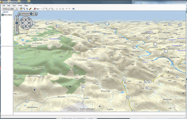
I have the 550t, and if I was to do it again, I wouldn't get the preloaded maps. My main issue is that I would like to use the Garmin topo maps in the Garmin Basecamp software, but Basecamp can not access the maps pre-installed on the unit. It can only access the CD or download versions of the maps. This is important to me because the Garmin topo maps have the elevation data embedded in the maps for the 3D views that you can see in the Basecamp software and the unit itself.
Basecamp
Unit

You can load the gpsfiledepot maps in the basecamp software, but you can't view the maps in 3D. I don't think I have tried to load the filedepot maps on the unit.
The only reason (that I can think of) that someone should get the 550t is if they are very intimidated by loading the maps on the unit with the Basecamp or Mapsource software.
So in short, buy the 550, try it out, and buy and download the 100K topo maps at home from the garmin web site if you want the 3D.
Thanks Justin. I'm not too worried about loading maps myself. I've done it before, although my current gps was in the middle loading maps when it failed communicating. That doesn't concern me enough to give up on doing it myself.
I don't care so much about the 3D either. I mean it's nice and all, but I guess I'd have to pay extra for the 3D 24K maps either way wouldn't I? Free or not, I want the 24k maps.
Unless someone else can convince me otherwise, I'll order the 500(no t) later today.
Off topic… Have you tried the City Navigator software on your Oregon? I'm thinking that may be useful when I get off trail to visit larger trail towns.
I have the Garmin Colorado 300 for around $400. and bought the TOPO USA CD for another $100. instead of the pre-loaded Coorado 400t so I could download it & up load to the GPS and still have it on my computer to print out maps and routes.
The difference between the pre-loaded and CD maps was explained above.
Ya gotta carry a map and compass anyway, as insurance, so why not print your own? Buy some good weatherproof map paper at REI and print only what you need.
Still, you need to hook up your Garmin, regardless of model, to your computer and download firmware changes yearly.
Oops, I meant 550, not 500.
No weatherproof paper for this trip. Too expensive. I have a local printer printing about 350 pages of maps for me right now. Color laser and freezer bags will have to be weatherproof enough for this many pages of maps.
I have put the City Navigator software on my 60cx and Oregon, but I have only used it for car navigation on the Oregon. Looking up "Points of Interest" was nice on the 60cx.
I assume that is what you'll be using it for?
Yep, POI's…like buffets, grocery stores, places to buy HEET. I may not get that software, but it's an option to consider.
It’s a lot cheaper to do the research ahead of time.
– Captain Obvious
One of the other possibilities is for maps is the Garmin Birdseye imagery. It’s supposed to come out this month, and $30 a year is really reasonable IMO.
You're absolutely correct about the research, however, there's no way I'm going to research every town and city along a 2700 mile trail that I may be forced to visit if I experience injury, starvation or gear failure….especially when my goal is to avoid those places.
That Birdseye stuff looks interesting. It seems like they're trying to compete with Delorme, except with less options and additional cost.
To follow up, I bought the regular 550. I already had Garmin's 100k maps. To that I added several maps from gpsfiledepot.com. I was able to load several topo maps worth 2.7 gigs onto a memory card. So far all seems well with the gps, so I think it's all good. Thanks for your help!
Gene,
Good luck on your trip.
Eric
Become a member to post in the forums.
 Lighting for your next tripLighting for your next trip
 © Beartooth Media Group Inc.
 Loading...