image here
This trip celebrated the reunion of two guys who did a lot of backpacking in the Kern Basin back in the 80’s, before the demands of family and profession forced my friend, Jim, to hang up his boots and backpack. We had always shared a common approach to being in the mountains and his absence left a gap that I was never quite able to fill. So when he let me know he was ready to pick up where we left off, I naturally wanted to select a route worthy of the occasion. The result was a nine day tour of 4 major basins in the Kern watershed, beginning and ending at the Shepherd Pass TH. It was strenuous, remote, and traversed some of the most beautiful country in the entire Sierra. All in all it was perhaps the best backpacking experience of my life. I also had an opportunity to subject 3 new pieces of gear, the ULA Ohm, Gossamer Gear LT4 poles, and Inov8 RocLite 370’s, to rigorous field testing. Reviews will follow shortly.
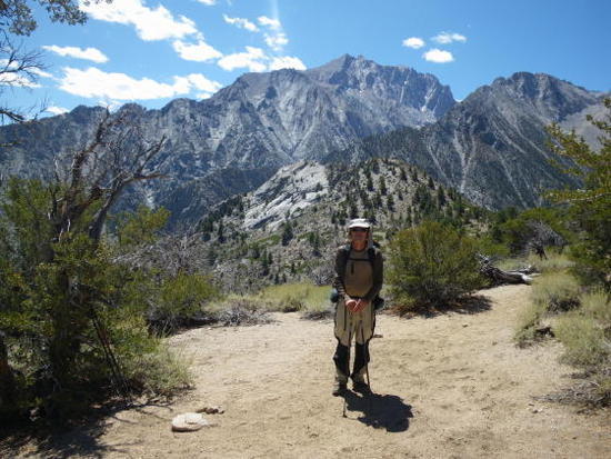
Tom on Shepherd and Symmes Creek Divide
This trip celebrated the reunion of two guys who did a lot of backpacking in the Kern Basin back in the 80’s, before the demands of family and profession forced my friend, Jim, to hang up his boots and backpack. We had always shared a common approach to being in the mountains and his absence left a gap that I was never quite able to fill. So when he let me know he was ready to pick up where we left off, I naturally wanted to select a route worthy of the occasion. The result was a nine day tour of 4 major basins in the Kern watershed, beginning and ending at the Shepherd Pass TH. It was strenuous, remote, and traversed some of the most beautiful country in the entire Sierra. All in all it was perhaps the best backpacking experience of my life. I also had an opportunity to subject 3 new pieces of gear, the ULA Ohm, Gossamer Gear LT4 poles, and Inov8 RocLite 370’s, to rigorous field testing. Reviews will follow shortly.
The Approach
Day 1
Shepherd Pass has a reputation that deters many folks from using it. I would agree that it is certainly very strenuous but the rewards are commensurate. It not only provides the most direct access to the Upper Kern watershed, but is also incredibly beautiful in its own right. SP has been my trail of choice for many years when entering the southern Sierra. Being advanced in years we naturally got off to a late start, approximately 9:30 AM, but were not particularly concerned since our goal for the day was the bivy site above the Pothole. Jim was carrying about 34 pounds, including 4 pounds of water, in his ULA Circuit and I was carrying a little over 30 in my Ohm, including 4.25 pounds of water. We took our time, enjoying the magnificent scenery and acclimatizing as we ambled along, arriving just after 5 PM. Both of us felt we could have gone on over the pass, but there wasn’t any particular advantage to doing so and the risk of feeling lousy or even contracting AMS counseled prudence. So, we settled in for the night and watched as the long rays of the sunset worked their magic on the White Mountains off to the east.

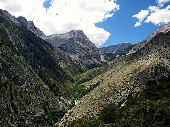
Shepherd Pass Trail
Shepherd Pass Headwall

Day 2
After the short hike up over the moraine and headwall of Shepherd Pass, we meandered down Tyndall Creek, enjoying the panorama of the great Western Divide in the distance. Our goal for the day was Junction Meadow down in Kern Canyon, so there was no reason to rush. At the junction with the JMT, we headed south for ~ 4.5 miles to the junction with the High Sierra Trail at Wallace Creek. The Great Western Divide appeared much closer now and, as we crossed Bighorn Plateau, we were treated us to two of the truly grand vistas in the entire Sierra, The Whitney Crest and The Great Western Divide. I have never cared much for the JMT and was glad when we trudged down the last long switchbacks to Wallace Creek and the High Sierra Trail. By the time we began the descent to Junction Meadow it was ~ 2:30 PM and the Wallace Creek gorge was beginning to heat up. The last mile or so before we reached the Kern Canyon Trail was quite unpleasant physically, due to the heat and dust, but the views of the entrance to the Kern-Kaweah Valley, guarded by an imposing detached pillar, on the other side of Kern Canyon made up for it. Tomorrow we would be on that trail en route to Kaweah Basin, the first of 4 we would visit. That really gave our spirits a lift.
The Basins
Day 3
After a leisurely breakfast, we rock hopped across the Kern River and ascended the Colby Pass Trail through patches of aspen, sage, and manzanita and worked our way around behind the detached pillar that stands guard at the entrance to the exquisite Kern-Kaweah River valley. Shortly afterward we passed by Rockslide Lake and left the trail to begin our ascent up the unnamed East Fork of Pickett Creek to Kaweah Basin. The fun was about to begin. After fording the main branch of the Kern-Kaweah River, we worked our way through brush and downfall to the secondary branch of the river and rock hopped/bushwhacked along it until we came to the end of the talus field on the other side and the east wall of the Pickett Creek canyon came into view. At this point we crossed over and worked our way up granite slabs interspersed with patches of currant bushes, always staying close to the wall. The key to this route is locating a boulder/talus filled gap in the wall which provides access to a broad bench that leads to the unnamed East Fork of Pickett Creek. There is one other way that I know of involving an awkward mantle up onto the granite slabs along the creek. It isn’t much fun with a backpack. Once on the bench, we walked over to the creek and began the ascent up to Kaweah Basin. This part of the route is only about 2.5 miles or so, but it is drop dead beautiful and involves a lot of micro route finding. There are a few class 3-ish friction and bush belay sections on granite of varying steepness that require careful attention to the business at hand while the boisterous creek cascades down and over granite slabs just a few feet away. It is, hands down, my favorite Sierra off trail route. As we topped out, we were rewarded with a stunning view of the Kaweah Peaks Ridge, reflected in a small lake, looming over the south arm of Kaweah Basin. The contrast between the ridge as viewed from Shepherd Pass or Bighorn Plateau and what we were seeing now is hard to describe; it can only be experienced. We dropped our packs in a grove of pines about 50 yards from the lake and set up camp in a pristine site, tired but elated. It had begun to cloud over so I broke out my tarp and, sure enough, a light evening shower made that a wise decision. The sky soon cleared off and we were treated to the first of several near full or full moon nights that had us gazing raptly at the beauty around us.
Day 4
We had planned day 4 to be a rest day and that turned out to be a good decision. We were both quite tired and unprepared to negotiate a scantily described off trail route of uncertain difficulty that we intended to follow back down to the Colby Pass Trail. We lazed around camp all morning, doing laundry, washing our fragrant, dust covered bodies, and lingering over a second cup of coffee. By afternoon, we were ready for a leisurely day hike further up into the basin over gentle granite slabs which had a surface texture akin to sandpaper. It was a delightful, carefree stroll with magnificent scenery everywhere we turned. And what a pleasure to drink the water untreated, without the slightest reservation. I drink water untreated a lot of places in the Sierra, but seldom without ANY reservations whatsoever. Along with no bears and no people, it is part of what makes the Kaweah Basin so special. Well, almost no people. Two day hikers happened by on their way back to Junction Meadow just as we were setting camp.
They were as surprised as we were. It was the second time I have seen other people in six visits to Kaweah Basin. The others were a twenty something couple camped on a small peninsula jutting out into the lake several years ago. I thought to myself at the time, “what a marvelous place for a young couple in love to spend a few days” and wistfully regretted not having thought of that myself in bygone days. That evening the weather was initially clear so we took the opportunity to wander around in our ID Hot Socks on granite slabs along the outlet stream as the nearly full moon rose. The play of moonlight on the water and the Kaweah Peaks Ridge was sheer magic. The peaks were ghostly, half in shadow and half glowing silver, while the stream resembled flowing mercury as it twisted and eddied its way toward an approximately 400’ drop off to a tiny lake below. Our esthetic senses satiated, we retired early as we had decided to move on the next morning.
Day 5
We awoke to an increasingly cloudy sky and there were droplets of rain on my tarp. We quickly packed and worked our way up over broken terrain through a gap in the ridge that separates the south and north arms of Kaweah Basin. We had initially planned to exit via the saddle immediately west of Pickett Guard Peak, but the weather was looking dicey and the approach ascended a substantial talus slope. Also, I was guarding a knee not entirely recovered from quadriceps tendonitis. In late July it had caused me to turn back on the third day of a solo trip to McGee Lakes via Lamarck Col precisely because I was afraid I’d compromise this trip. I certainly didn’t want to blow it now. So, we made an impromptu decision to head northeast, following the chain of lakes that empty into Pickett Creek, from whence we would descend into the Kern-Kaweah River valley. In 2005, I had dropped from the last lake in the chain almost straight down the southwest wall of the Kern-Kaweah Valley via a rotten gully, and I had no appetite for a rematch. Somewhere, I had heard that there is a ramp that angles north down to the river, probably what Secor meant in his vague description in The High Sierra, p. 74 , and we hoped to find it this time. The slope below the last lake that leads down to the Kern-Kaweah River is very steep and it is easy to drop too low before traversing north to pick up the ramp. I made that mistake in 2005 and it led to a very nasty descent. We tried to stay aware of this as we descended but still ended up too low, which became manifestly clear when we rounded a granite ridge to confront near vertical cliffs. Perhaps we had been distracted by the spectacular views of the Whitney Crest off to the east. I had never before seen the Crest from this perspective and it was a real mind blower. It was all there, from Tyndall, Williamson, and Barnard, down to Russell, Whitney, and Keeler Needles. I just hope Jim’s pictures do it justice. As well, we had a bird’s eye view of the creek we had ascended on the way in. Upon realizing our mistake, I scrambled back up the slope ~ 100’ or so, angling north, and the route down the ramp became obvious. Once on the ramp things were fairly straightforward, although our descent was complicated a bit by a substantial shower. It was enough to make us break out the wind shirts and pay very close attention to avoiding lichen patches on the slabs. A fall would definitely have had consequences in certain places. As we reached the valley floor, the shower stopped abruptly and we were treated to an entire valley wall of granite slabs glistening silvery in the sun. After crossing the Kern-Kaweah River we still had ~4-5 miles of hiking on the Colby Pass Trail to reach our destination for the night, a grassy meadow next to some small lakes at the entrance to Milestone Bowl. The miles went quickly and we thoroughly enjoyed our hike along the Kern-Kaweah River, one of the most scenic in the Sierra. After plodding our way up two sets of steep, dusty switchbacks we emerged into the wide, open valley just below Colby Pass and began a rising traverse to the north to reach our intended campsite. We arrived around 4:30 PM and set up camp in time to relax and enjoy a spectacular sunset, complete with some unusual green and yellow clouds just over Colby Pass backlit by the usual array of red, purple, and orange formations. Jim confidently predicted it would be our last for a while because the weather was finally going to clear up. When the sun set, it got quite cold, down in the mid to high 30’s by morning, with a stiff breeze that soon had us in our down jackets, Windstopper beanies, wind shirts, and Powerstretch gloves. It was the night of the full moon and the views of the west rim of Kaweah Basin to the south and the craggy ramparts of Milestone Bowl above us were memorable, indeed. After a cup of hot tea, we retired early in preparation for what would turn out to be the most challenging day of our trip, the crossing of Milestone Pass into Milestone basin.
Day 6
We got off to another late start, calculating that we had plenty of time to make it over the pass and down to good camp sites by the upper lake in Milestone Basin. This was optimistic and we ended up cutting it pretty close by the time we finally reached the lake, both energy wise and daylight wise. I had been over Milestone Pass 3 times previously, twice from north to south and once from the south, our direction. Crossing the pass is a strenuous affair at best, and my last time over, going north, I had ascended on the right (east) side of the bowl. This was not the best choice, as we encountered very large, awkward, often unstable talus down fairly low which made for slow going. I was also 4 years younger and, at 69, I knew better than to try that again. So we stayed to the left (west) side and picked our way carefully up granite slabs interspersed with occasional short stretches of talus, delaying the transition onto 100% talus until about 200’ below the pass. It was still slow going, but less strenuous. We were further delayed when we couldn’t find water at the usual source and wasted about 40 minutes descending to the last tarn to fill our bottles, only to find another source higher than I remembered. By the time we reached the pass it was mid afternoon. Upon locating the proper crossing on the second try, Jim was initially a little uneasy, so I traversed a little further west trying to locate the keyhole I had used both times crossing from north to south. Nothing looked particularly appealing from the south side, so we went with the standard crossing I had used on my last trip. But the delay had cost us another 20 minutes or so. Jim felt it was a lot easier than it had initially appeared and we were soon down on lower angle talus. By now it was ~4 PM and we still had to descend ~1000’ of smaller, but frequently loose, talus to reach the granite slabs along the first stream below. Our fatigued state and the fading daylight combined to make this a daunting proposition. After pausing briefly to select a line of descent, we carefully worked our way down to the stream draining the slope below Midway Col and the westernmost high lake on the north side of Milestone Basin. It was a slow tedious process on tired legs and we heaved a big sigh of relief when we finally stepped onto nice solid granite slabs and followed the stream down to the first lake. We ended up camping on a level, sandy patch next to Milestone Creek just downstream from the lake. It provided an unobstructed view of Milestone Mountain and the pass we had just crossed, and was perfectly situated for the moonlight show soon to follow. The sky was clear so we didn’t bother with tarp or tent and, after snarfing down our evening meal, we settled in to watch the moon, at full plus one, bathe Milestone Mountain and the walls of the basin in soft, silvery green light. Suffice it to say we were not disappointed. However, the cumulative fatigue of 5 strenuous days with only one layover was beginning to take its toll; we turned in early, totally exhausted, and slept the sleep of the dead, show or no show.
Day 7
We awoke to a bright, sunny day, with nary a cloud in sight. After a leisurely breakfast, we lazed around camp until nearly noon. There was no need to hurry, for our next campsite, just below the lake with 3 bays in the Upper Kern Basin, was only 3 miles away. We meandered slowly down Milestone Basin, following the chain of lakes and then the stream until it began its plunge into the Kern Canyon. At that point we angled northeast to pick up a trail that led down to the Kern Canyon trail at the entrance to Milestone Basin. From there we headed north to what turned out to be our final campsite, a seldom used gem whose exact location shall remain anonymous. It was my first campsite in the Upper Kern 35 years ago and I have visited it every year since, excepting two years when I was either overseas or injured. Thus, when we arrived and discovered that some idiot had built a huge fireplace, we were outraged. Jim and I looked at each other and knew what we had to do. We dropped our packs and set to work dismantling the monstrosity in a manner that would preclude the stones ever being used to reconstruct it. A note of explanation is probably in order: Down through the years it became obvious to me that a small community of like minded people was using this campsite, and that a set of rules held in common applied to its use. I never met any of them, but we all made sure that the site was left in immaculate condition, with kindling and a day’s supply of firewood tucked away under a leaning log back when fires were permitted. When fires were subsequently banned the fireplace was deconstructed, by common agreement never to be used again….until this fool came along. Mission accomplished, we settled in to enjoy the remains of the day, with nothing more ambitious on the agenda than the evening meal and contemplating the beauty around us.
Day 8
We planned to begin the trek back to civilization tomorrow. The first 6 days had been pretty strenuous. Day 7 had been easy but we were still a bit tired and spending our final day languidly exploring the broad basin situated below Thunder Mountain seemed just right. It is a special place, beautiful in a way that is difficult to describe. If anyone reading this report visits, or has visited, it they will know what I mean. Jim and I have both been there many times before, but we never tire of the place. The stream, with its 4 waterfalls, is exquisite. Abundant trout, pure water, and soaring ramparts leading the eye ever upward to Thunder Mountain presiding over all, make it a mandatory day hike whenever I am in the Upper Kern Basin. When clouds gather the sunsets are beyond compare and, if you are fortunate enough to be there during a thunder storm, you will understand how the mountain got its name. And so our day was spent, slowly soaking in the beauty and nourishing our souls. Shortly after we got back to camp we had a visitor; as I was returning from the lake with water, I noticed a flicker of movement out of the corner of my eye. I froze and slowly turned my head. There, not 20 feet away was a doe, cautiously easing her way into camp. Without moving, I gave Jim, who was dozing on his sleeping bag, a heads up in a soft voice. By the time he slowly sat up the doe was perhaps 15 feet or so from him. Over the next15-20 minutes, he snapped several pictures at close range. Usually deer are much more reticent than this one was. It’s the closest either of us had ever gotten to a deer up there. Go figure, but it was a delightful experience anyhow. She fed on willow tips around camp for awhile and then leisurely departed. All in all a very pleasant day in an area that has long since become a home away from home for both of us. Each visit we see thing anew, but also have that feeling of coming home. Hard to describe, but we both experience a sense of deep satisfaction, a sense of belonging here. During our many visits down through the years, we have made this place our own in a way. It was certainly our own this time, for there was no one else in the Upper Kern, nor in Milestone Basin. It was a very special feeling.
The Horses Smell the Barn
Day 9
We had initially planned to spread our return trip over 2 days, as I was unsure how my leg would stand up to an 18 mile day that included ~6,600 feet of elevation loss, most of it coming down the rugged Shepherd Pass Trail. That’s what we were still thinking when we broke camp and proceeded very slowly up over the broad ridge that separates Upper Kern country from the Tyndall Creek drainage. We lazed our way up Tyndall Creek until we were below the lake at ~11,780’ directly south of Diamond Mesa, our original destination for the day. It was only noon so we figured why not continue on to the bivy site above the Pothole and leave only 10 miles tomorrow. But the wheels had already began to turn; By the time we reached the bivy site, it was only 3:30 PM, and we both piped up at the same time “ya know, we’ve still got enough daylight to make it back to the car by 8, which means we can get a motel, shower, and PHOOD(food)”! The rest is history. We mixed up 4 packets of Perpetuem apiece in 12 ounce bottles with enough water to make a thick slurry, filled our other water bottles, and headed for the barn. We stopped briefly to refill our bottles at the last water source below Mahogany Flats and kept on truckin’. We finally had to break out the headlamps just as we reached Symmes’ Creek and cautiously continued on, probing with extended hiking poles at the margins of the trail for rattlesnakes. We got to the car at 8:10 PM and arrived in Bishop around 9:20. After a VERY quick shower, we slipped into Whiskey Creek Inn just before closing time to stuff ourselves on a gigantic tostada salad (me) and a big, fat burger with the works (Jim). It was a fitting end to an 18 mile day that concluded a near perfect trip. We hung around Bishop for an extra day, trying not to break the spell, then reluctantly pointed the car north to catch a flight from Reno back to Seattle.
image above

imga

mmm