Topic

Question on an area in High Sierras

  • This topic is empty.
Viewing 7 posts - 1 through 7 (of 7 total)
Aaron Sorensen BPL Member
PostedMay 9, 2009 at 2:50 pm

Hello all,
I have seen a few posts of some fast-packers that have gone off trail in many of the areas of the high sierras.

I am looking do a super hard 2 day out and back from Roads End (180) to Muir Pass and back.

I will stay the night in Muir hut.

I will be following the trail from roads end due north the way the sierra high route goes but I have a question on one stretch that I would like to short-cut to get to Muir.

From Horseshoe Lake the High Route starts to head east.

I would like to go up Windy Canyon until I get to Kings River and then stay along the Kings River until I meet back up with the JMT.

It looks very possible but that doesn't mean anything when just looking at a map.

So has anyone experienced that area first hand to know weather or not it is plausible?

The hike will be around 52-55 miles each way.
So probably something like 3am to 11pm the first day get about 6 hours of sleep and 6 am to 2am on day two.

Here is a map to check it out:
http://www.onthetrail.org/OTT/images/shr/HSR%20100Kv2.JPG

Jeff Jeff BPL Member
PostedMay 9, 2009 at 3:11 pm

I would ask on High Sierra Topix about the route, but not the time frame. Might want to leave out the fact that you will illegally "overnight" in the Muir Hut.

Aaron Sorensen BPL Member
PostedMay 9, 2009 at 4:09 pm

Thanks,

Just outside the Muir Hut then.
It would be a better view to overlook evolution anyway.

I think there is more expierence here than on HS topix.

PostedMay 9, 2009 at 4:20 pm

Aaron,
The link you provided is to the 100k map, a 62MB image. The "500k" link is right beside it, and at 2.5 MB loads a lot faster.

Jeff Jeff BPL Member
PostedMay 9, 2009 at 4:35 pm

I'm not nitpicking, but there are rangers that post there that might. Anyways, you can ask about any obscure drainage, creek, basin, peak, etc. Someone there has probably done it.

This place may have more lightweight experience, but I guarantee HST knows the Sierra topography better.

Klas Eklof BPL Member
PostedMay 11, 2009 at 8:41 pm

Aaron,

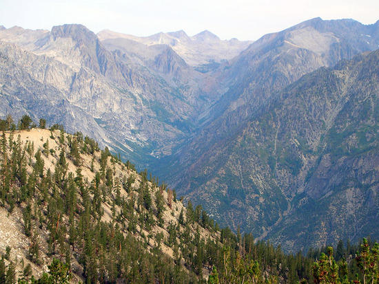
Great idea. I don't know anyone who has attempted Windy Canyon, so I'm not sure it can be done "easily". But here is a little info anyway.

This is a picture from the headwaters of Windy Canyon, looking NNW, from about 10,400'.

w1

That's Mt Woodworth in the center, Devils Crags to the right.
The cross-country route from Horseshoe lakes to this spot is easy, just head due north thru the forest, and don't lose altitude. And it appeared to me that it would be very easy to get down into the meadow below. How steep does it get around the corner? No idea. How bad the bushwhacking? No idea.

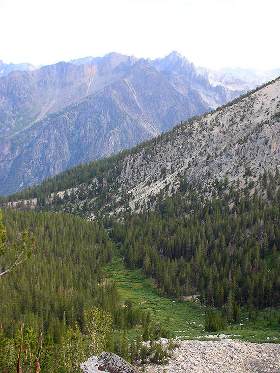
This is taken from the same spot, looking a little more NW, directly up Goddard Creek, Mt Reinstein at center.

w2

The bushwhacking in Windy might very well be just as bad as the bushwhacking in Goddard Creek.
And then there is the steepness. Secor, 3rd Ed., pg.192, "Wrinkle: All the canyons that lead north from the Monarch Divide turn into hanging valleys before dropping precipitously into the Middle Fork. The only reasonable route is the Granite Pass Trail…"

The problem is, it's not really clear if he considers Windy Canyon one of those canyons. It might be, it might not.

For a sure thing, you could take the Granite Pass Trail, and then climb up Goddard Creek and go over Wanda or Black Giant Pass. In order to get to the hut where you won't be sleeping. Careful, it leaks.

– Klas

Aaron Sorensen BPL Member
PostedMay 18, 2009 at 10:28 pm

Thanks Klas,
Doesn't look like that will be a time saver.
Awesome photo.
I don't know how you came up with this one. It is in the middle of nowhere.

Viewing 7 posts - 1 through 7 (of 7 total)
Loading...