Topic

iPhone 3G GPS mini-review


Forum Posting

A Membership is required to post in the forums. Login or become a member to post in the member forums!

Home Forums Gear Forums Gear (General) iPhone 3G GPS mini-review

  • This topic is empty.
Viewing 16 posts - 1 through 16 (of 16 total)
  • Author
    Posts
  • #1230216
    John Carter
    Member

    @jcarter1

    Locale: Pacific Northwest

    I was one of the fortunate few who obtained an iPhone Friday morning, and I had a chance to test out the GPS over the weekend.

    One of the big unanswered questions of the past few months is whether it would have a true GPS or A-GPS. The terminology is confusing; for some phones, A-GPS means it is a very limited GPS that requires cell phones to find a lock. Other A-GPSs are dedicated GPSs which use cell towers to enhance the signal. Obviously for backpacking, a phone must be able to obtain GPS and maps with no cellular connection. It also needs to be very accurate; some of the street mapping GPSs can get away with a less sensitive GPS because they can 'lock' the GPS marker to the road, making an otherwise erratic signal look straight and on target.

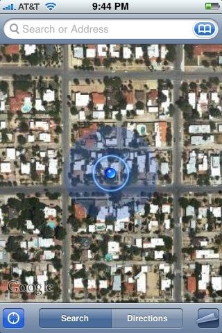
    I am happy to report that the iPhone indeed has a dedicated GPS, and it appears to be a good one. I was able to test this on a trip through the northern Rockies, where I was in the mountains, just off the freeway, in a creek with steep mountains nearby. I did have clear view of the sky, but only above me. I had no cellular signal. When I open Google maps, all I have to do is tap the button in the lower left corner, and it turns the GPS on. No messing with com ports or bluetooth settings. It was able to lock in about 45 seconds–typical of a good GPS. Fortunately Google had cached its maps, so I was still able to use the maps. By walking around a bit, I was able to move the GPS marker around 'off the grid' — that is, the marker did not try to lock to a road, but instead followed me around on the white space between roads.

    Here's where it gets really cool: sometimes there is a light blue circle around the GPS marker that varies in size. This indicates how accurate the signal is, so that as the signal gets weaker, the circle gets larger. This gives you an estimate of signal accuracy, and visually lets you know that you are probably in the center–but could be anywhere within–the circle.

    I am also happy to report that, with all radios turned off except GPS (cellular, wi-fi, bluetooth), and the brightness turned down, the battery lasts a VERY long time. I can't give estimates, but I think it's the longest-lived PDA-phone battery I've used (I've owned a Pocket PC, a Smartphone, and a Palm). This is combined with the fact that when I close Google maps, the GPS is turned off. When I open Google maps, I simply push a button to turn it back on. This is far more power efficient than turning on and off a bluetooth/GPS switch that is usually buried illogically in some sub-menu.

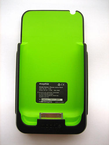
    As a side note, for those concerned about a field-replaceable battery, check out the Mophie juice pack. This is an external battery sleeve/protective case that triples battery life, and they've got a 3G version coming soon:
    Mophie
    Based on my experience with my wife's 1st gen iPhone (I can usually browse the internet for 4-5 hours on hers and still have a half-full battery) I feel very good that this would get you through to your next resupply point, assuming you do not leave the GPS on for tracking.

    Anyway, back to the pre-review: The phone itself feels twice as thin as the original. Even though it is basically the same thickness in the middle, the tapered edges make a huge differences in feel. And the plastic back is a very hard, strong plastic. The screen is of course optical quality glass, not a fragile touch screen of other PDAs. The Garmin models will always be more waterproof/ruggedized, but the iPhone is one of the strongest-feeling phones I've ever handled. Add a protective case an an Aloksack and you can handle serious weather. The only downside might be that you have to take gloves off to use the touch screen; I have not tested this.

    Of course the one big glaring problem is that there are no topographic maps for the iPhone yet! =). That's why this is a mini-review. However, two big navigation companies (Tom Tom and TeleNav) have plans to create street maps, so it is only a matter of time before we see topo software.

    And this is, to me, the most significant reason to use a PDA Phone instead of a Garmin/Magellan: For years PDA phones have had access to full, detailed 1:24,000 (7.5 minute) topo map images. These are scanned images of the actual USGS maps. So what you see on your PDA is what you see on your paper map. Pocket PCs, Smartphones, and Palm devices have all had software to do this for years, whereas the Garmin and Mgellan units still only use digitized versions (raster maps) at 1:100,000 zoom. For some, 1:100,000 may be sufficient, but I can think of 4 times where having a 1:24,000 map on my GPS got me back on track faster than the 1:100,000 zoom level would have. This was what pushed me over to PDA GPSs 4 years ago, and why I used to tolerate all the problems associated with PDA GPSs vs dedicated devices. It lets me use the device as my main navigator with the paper maps as a backup, rather than the other way around. but far more important to me is that I DON'T HAVE TO PRE-INPUT MY WAYPOINTS. If I decide to change my route plans, I don't have to worry that my GPS is no longer tracking to the next waypoint. I just change plans and go. Sure, it takes a lot of device memory to do this, but with a 16GB model, you could load entire mountain ranges of high-quality scanned maps into an iPhone.

    There are already some very useful apps available to download. There is a star chart that combines the GPS with the accelerometer so that you simply point the device towards the sky and the program displays what you are looking at. There is also a sunrise/sunset app as well as a great weather app with live animated radar maps coming soon (though you need an internet connection for that). And there is a really cool app that lets you find other iPhone users on Google maps, much like a homing device. Unfortunately the app is buggy and you need an internet connection, but this has real potential in some outdoor situations. Downloading these apps directly onto my phone has exceeded my expectations for simplicity.

    Anyway, I've had high hopes for this device for some time, and have been anxious about the lack of info about the GPS. I would have been really disappointed if the GPS was crippled. The iPhone 3G has exceeded my expectations. Once a topo map software program comes out, I will do a full review in the reviews section. But at least on the hardware side of things, I see no reason to use a dedicated GPS device anymore.

    #1443403
    Mike W
    BPL Member

    @skopeo

    Locale: British Columbia

    #1443406
    John Carter
    Member

    @jcarter1

    Locale: Pacific Northwest

    At this point the only mapping program on the iPhone is Goggle maps, which does not do breadcrumbs. However, I would be willing to bet you good money that you will be able to download a mapping program that does this by the end of the year. Developers have only had 3 months with the iPhone SDK (the software that allows developers to write programs for a given OS), and 3 months is only enough time to develop basic apps. But every other mobile software platform has such software, so it can only be a matter of time. Consider that over 200,000 copies of the SDK have been downloaded, and that the iTunes app store saw 10 million downloads in the first 3 days of the store! This is by far more than any other device. Some developers have already become successful (10 million apps downloaded and only 500 apps means some people got rich overnight). Super Monkey Ball has already grossed over $600,000 in less than a week, for example. Anyway, my point is there is tremendous pressure on developers to develop such apps, and the first ones to it have a chance at some real money.

    My point in all this is that I wouldn't let a bread-crumb feature make or break your decision on the iPhone–give it few months. My point of this review was to focus on clearing up some of the hardware ambiguities.

    EDIT: Just noticed my string of "My point is…" sentences here. Sorry about that, I was in a hurry! =)

    #1443407
    Don Wilson
    BPL Member

    @don-1-2-2

    Locale: Koyukuk River, Alaska

    Yeah, I agree the potential with the iPhone is incredible.

    It is important for people to know that the software that is available today is not really intended for off road use yet. But the quality of the GPS does appear to be quite good in my tests too. And Apple has opened up the iPhone so many, many companies can write software for it. It's mind boggling to consider what could be done within the next year or so.

    Here's a screen shot of the mapping software and GPS at work, integrated with Google maps. Note that you can faintly see the light blue circle indicating the uncertainty of the position. Note that the position is very accurate though – I was sitting in my living room directly under the blue dot.iPhone 3G GPS and Mapping Screen Shot

    #1443422
    John Carter
    Member

    @jcarter1

    Locale: Pacific Northwest

    Don,

    It's great to see a BPL staff member with this Phone. How did you capture that screenshot? It is nice to get a GPS signal indoors, but it's likely the cellphone/wifi is helping out. I look forward to giving this a try a bit more in foliage, canyons, etc, making sure the phone portion is turned off.

    #1443431
    Ulrika Dahlin
    Member

    @ulrika

    John,

    Apple made it very easy to capture a screenshot.

    Just hold the "home" button down and tap the "on/off" button once.

    The screen will flash and store a screenshot in your camera roll.

    #1443440
    Don Wilson
    BPL Member

    @don-1-2-2

    Locale: Koyukuk River, Alaska

    Hi John –

    Yes, good point re assistance to the GPS. Mostly I wanted to let people see the integration of Google maps and the GPS.

    I'm looking forward to seeing what happens with navigation applications. Who knows, we may even develop some BPL apps.

    Don

    #1443457
    John Carter
    Member

    @jcarter1

    Locale: Pacific Northwest

    "Just hold the "home" button down and tap the "on/off" button once."

    That is very cool. There are some really useful hidden features that Apple does not advertise; I thought I had learned them all.

    I just learned this week that you can double-tap the space bar to get a period followed by a space. I think my favorite hidden gem is the ability to double-tap the home button to go straight to the iPod controls.

    EDIT: I forgot to mention that the iPhone 3G screen has been improved for outdoor use. Apple stated this week that the new screen is brighter and has more contrast. I can easily see the screen outdoors at half brightness with sunglasses on, something I can't do with my current GPS.

    #1443462
    slavenya slavenya
    BPL Member

    @slavenya

    Locale: Israel

    Hi Guys,

    I was wondering is there any other PDA, GPS, phone over there that worse looking at them? Garmin nuvifone?
    Iphone is really hard to buy. At least I do not know good way to do it. I need unlocked one, since in my country there is no Apple carrier.
    Any suggestions?

    #1443488
    John S.
    BPL Member

    @jshann

    Within days of the 3G iphone release, Brazil had already unlocked it. In a few years, unlocked iphones may be commonplace.

    #1443671
    Josh Certain
    Member

    @hgother

    First I just have a question: you say you turned off the Cell radio–how did you do that? Airplane mode? (I didn't know gps worked in airplane mode!)

    Also, I wanted to point out that you can always use a very lightweight solar charger for this. It's not hard to make a DIY one that will come in just over an ounce (if that).

    Lastly, this isn't too relevant to backcountry, but I thought it was an interesting insight as to what may come out of google in updating their maps program:

    If you connect the phone to power like in an iPhone Car dock, and then lock on GPS in google maps, not only will the screen track with your blue dot, but it will stay on (no lock or screensaver) so it is somewhat helpful for driving nav. Hopefully they will port over google earth and then we will be set. Someone else has been demoing a google earth alternative that runs on it, even using the gyros to move around instead of touch.

    #1486685
    Celia Clause
    Member

    @eli_northwest

    It looks like a few apps for the iphone just came out this week supporting TOPO. One that looks promising is http://appshopper.com/navigation/itopomaps. It seems to have all the basic hiking gps feature. I'd love to see a review of all of them and a comparison of the features. I'd rather pay a little more if I know it works well, than buy junk. At this point I've just read what's on the app store though.

    #1490037
    Dara Parsavand
    Member

    @dara-parsavand

    I share Celia's interest in the new iPhone Topo apps. So far, I see 4 that look like the display USGS Topo maps (I see mentions of GeoTIFF, never GeoPDF) and use the iPhone 3G's GPS to locate you on these maps. These are:

    http://www.itopomaps.com/
    http://www.ebranta.com/topopointusa.html
    http://chezphil.org/topomaps/
    http://www.cynicsoftware.com/topos2go/

    I found these searching for topographic in the app store and looking at all choices under the Navigation category. I'd also be very interested in a comparison review – perhaps some backpacking site (this one?) can pony up $50 or so to try them all and tell us the best ones (for a given task). I guess I have the money, but at the moment, I don't have the time to do it justice, so I'm stuck reading a few different reviews and taking a guess. I'll probably pick one of first two as they look a bit more polished than the last two, but I'm not sure yet. I would have preferred an open-source app, but I'm not aware of any. Perhaps there will be an open-source solution for the Android platform (I'll probably move away from the iPhone to an Android phone after they get a few more phones out – the G1 was pretty flaky for me).

    Dara Parsavand

    #1495161
    Poul Kjeldgaard
    BPL Member

    @pro2type

    If the the nPower PEG (sheduled to be available july 09) keeps up to its promise – maybe it wont – it could change how some of us use electronic devices in the trail. Including using the iPhone.

    nPower PEG is essentialy a personal powerstation based on the activity we do most: Walking, and should repower an iPhone to 80% with an hours walking.

    greennpower.com

    #1497018
    Dan Gaines
    Member

    @cynicbackpacker

    I am the developer of the Topos2Go app mentioned in a post above. I just wanted to let you know that I also made a free version of the app, Topos2Go Free, so you can get an idea of what it is like and verify that it will meet your mapping needs before you buy the full version. The only thing missing from the paid version is that the paid version will locate your position on the map and, with an upcoming update, the paid version will allow you to import/export waypoints.

    I am more than happy to answer questions you may have about the app and I would love to hear any feedback you may have.

    #1511207
    nancy jocoy
    Member

    @jocoyn

    I do not have the phone yet – will get a new phone in November for MANY other reasons — but the topo app intrigues me as a possible "gear reduction" opportunity.

    If the GPS is "good enough" I may be able to forgo an upgrade to my cheapo foretrex that is good enough for what I need except under heavy canopy.

    1) accuracy – I assume the internal antenna is a limiter – I am pretty good if I can get inside a 10 meter area.
    2) fix under heavy cover? Think eastern deciduous forest
    3) datums – depending on where we are, we have to use NAD27 or WGS 84
    4) coordinate systems? UTM? USNG(MGRS)? DD.DDDDD, DD.MM.MMM, DD MM SS.SS?
    5) Waypoint logging and uploading?
    6) Track uploads – saving tracks and truncating start and end point? – can tracks be uploaded say to easy gps or mapping SW?
    9) Use of external antenna for more accuracy, better fix?
    10) Navigation? [ I don't really use a GPS for that too much, but it can be nice to get back to car etc.]

    The scanned maps are typically in NAD27 but I assume datums is appropraitely switched?

    The compass in the new one looks nifty but I don't think I am going to throw away my sighting compass.

Viewing 16 posts - 1 through 16 (of 16 total)
  • You must be logged in to reply to this topic.
Forum Posting

A Membership is required to post in the forums. Login or become a member to post in the member forums!

Get the Newsletter

Get our free Handbook and Receive our weekly newsletter to see what's new at Backpacking Light!

Gear Research & Discovery Tools


Loading...