


.
Topic
Become a member to post in the forums.
.
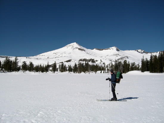
Here's early april from lake of the woods.
I'll be going back on July 4th, if that's before your trip I'll give you an update…
Dave, I am interested in more info on this death march lol. I will be looking at your link in a few. My TRT trip looks like it wont happen till end of july so I keep planning more training runs. I was up at the silver fork of the american yesterday and took my daughter on her first hike(2 miles, she slept most of it) and there is no snow to report there. I think I was around 5-6 thousand feet. Snow looked patchy higher up from what I could see ahead of me. I might take a trip out there one of these days and explore, gas prices hold me back.
The meltoff's pretty advanced compared to a normal year. I went a few miles up Lyons Creek trail two weekends ago, and it's rare that the Wright's Lake and Icehouse roads are open for Memorial day, much less the trails clearing off (admittedly, the trail itself was a creek and not a trail).
We have had a lot of warm, sunny weather since then and now it's downright hot. The high basins and chutes are certainly still snowed in, but I imagine they're melting off quickly. It "helps" that we had the driest Sierra spring since recordkeeping began.
i was just up to loch leven lakes – a hair under 7000 ft – and there is just a bit patchy snow in the shade at that elevation. my guess is above 8000 ft unless in full sun there'd still be a foot or two all over, so north facing & in the trees at 8k + i'd think be snowbound still
Just read that link. I have yet to explore desolation in depth and though I might skip a peak or two that sounds like a great trip.
I attempted Mt. Shasta last weekend. Had a crampon malfunction that kept me from a summit attempt but I am very happy with my training so far. I was with my brother and his climbing buddy(Matt) from Denali last year. Anyways Matt did the high sierra last summer and is doing all he can to entice me into that region this summer as well. Personal reasons have me moving out of state at the end of summer and I guess im just trying to pack it all in now. It all comes down to work though. My family is here so I hope to visit every few months. Will probably move back eventually but its time to experience some different scenery. Sorry for the highjack Dave….If I head up again I will update any snow pack I experience.
Hello,
I, too, am interested in the snow levels on the TRT. My plans are to start at Tahoe City and do a clockwise route. I keep checking the Tahoe Rim Trail website but their latest update is june 9th with most of the snow off off the section north of Tahoe City.
Governor Arnold says that we are in a low water year in California………
…full speed ahead, darn the mosquitos! Randy
True enough. The current PM2.5 particulate data show Placerville at the "very unhealthy" 200+ level, which is astonishingly bad. The high ozone is just an extra bonus.
Nearly 1,100 fires in California at present :-(
p.s. Eldorado National Forest should have up-to-date snow info: 530-622-5061
The Western States 100 has been canceled due to poor air quality, the first cancellation in 35 years.
It just ain't healthy out there.
Hi Dave, I didn't forget. I'll post the shots over in Trip Reports, just to keep everything organized around here…
It wasn't too smokey.
You should go for it.
Best.
– k
Become a member to post in the forums.
 Creamy Dijon ChickenCook-in-the-bag chicken, tarragon, and rice backcountry meal with 2 servings. Net weight 5.7oz | 162g
 © Beartooth Media Group Inc.
 Loading...