


All I am looking to spend 5-6 days hiking in these two areas of Western Colorado next August. Preferably in areas that have less traffic that follow rivers/creeks and end at an Alpine lake. Any suggestions?
Topic
Become a member to post in the forums.
All I am looking to spend 5-6 days hiking in these two areas of Western Colorado next August. Preferably in areas that have less traffic that follow rivers/creeks and end at an Alpine lake. Any suggestions?

A classic Weminuche hike is to use the Durango & Silverton Narrow Gauge Railroad as a shuttle to connect Elk Creek and Needle Creek. These two east-west valleys are connected by crossing the passes into the Vallecito Creek valley which runs north-south. The Needle Creek part of this is the Chicago Basin, which can be crowded with climbers trying to bag fourteeners and thus forbids campfires and has rangers patrolling for scofflaws somewhat regularly. Thus, personally, I'd recommend going up Needle Creek first to get the pain out of the way early, so go counter-clockwise. This also allows you to gauge how fast you're going, to decide if you want to add the loop up Rock Creek to hit those lakes as well. This is a common enough plan that the D&S RR includes a boxcar for hikers to stow their packs, and has different rates for them.
Dean, can you provide some more information? I have had a difficult time finding information online for either of these areas.
Sure, if you're interested. I just happen to have a googlemap done. Here:  To orient you, that lake in the lower left is Electra Lake. Durango is offscreen 25 miles or so to the south, and Silverton is just offscreen to the north. The D&SRR doesn't follow Rt550 the whole way- it cuts up the Animas River gorge, and connects the two trailheads. Elk Creek is the northern, and Needle Creek the southern. As I mentioned, I recommend counterclockwise because in August the Chicago Basin will be crowded so you may as well get that over with first. The red route is the longer one, with that bit jutting out to the east being the hike up Rock Creek to some larger lakes. If you find yourself running late, though, you can bypass this on the grey route. The Trails Illustrated map is adequate. This route is sometimes called the "Chicago Basin loop" or the "Elk Park-Chicago Basin loop" so you if you google that you'll find a lot: http://www.trimbleoutdoors.com/ViewTrip/1502965 https://www.trails.com/tcatalog_trail.aspx?trailid=HGR199-005 Heck, here at BPL: http://www.backpackinglight.com/cgi-bin/backpackinglight/forums/thread_display.html?forum_thread_id=81030 One of the great appeals of the Weminuche, though, is the ability to just pick a trailhead to start and then wander at will for a few days without a plan, including off trail if you like. Everything there is pretty spectacular- you just can't go wrong. The only other truly crowded place to avoid is Rainbow Hot Springs, but that's all the way on the east side near Rt160 north of Pagosa Springs. Then again, if ogling a crowd of naked hippies is your thing then maybe you'd like it. It's 4.5 miles up the West Fork San Juan River- easy to find stuff about it via google: http://www.uncovercolorado.com/hot-springs/rainbow-hot-springs/
How did you get google maps to look like that? What is the total distance and elevation gain/loss of the red route? What is the total distance and elevation gain/loss of the grey route? I know very litte about map navigation, is there something I am supposed to be seeing on the trimble website? I see a whole lot of information, I am kind of overwhelmed by that page and I don't understand any of it. This is an area that I am very weak on at the moment as going on long hikes that requires maps is something I am relatively new to even though I have been hiking for a really long time. I am planning on taking courses on this and increasing my knowledge and skill in this area before taking this trip or other long trips next year (I'm scheduled for a course Oct 31st and plan on taking many more). Plus I am bringing a Garmin and a Delorme Inreach. Thanks for the information. If anyone has information that can help me to learn how to use topo maps that would be greatly appreciated.
How did I get it to look like what? The terrain view? On GoogleMaps near the search bar is an icon that looks like three horizontal lines- that's the menu. Open it and click on 'Terrain'- the little icon that looks like a mountain. This makes it a topo map, though if you zoom in very close you'll lose the contour lines. If you're asking about how I placed the lines, you have to have a Google account- just a Gmail account, really. Then, if you're logged in to Google, when you open that menu on Googlemaps one of the options is 'My Maps.' On that you can draw lines and do other stuff, and save the maps. The red line as shown is 50 miles or so. If you take the grey bypass it's about 37 miles. I don't have a gps track for this, but you can probably find one by googling around a bit. (I don't use a GPS.) I cannot quote an elevation gain/loss, but here is the elevation profile on that trimbleoutdoors website: 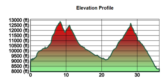 This is only for the 37-mile route, and clockwise is left-to-right, counterclockwise is right-to-left. So you can see that clockwise is almost 8k gain and 8.5k loss, and counterclockwise is reversed with 8.5k gain and 8k loss. Bear in mind that profiles like this exaggerate the vertical scale and make it seem more steep that it is. For instance, that first peak on the left looks like almost 45-degrees, but it isn't. Read the axis labels. It's 3750 feet of gain over about 8 miles- so only an average of 468 feet per mile, though it no doubt DOES get very steep right before the pass. On the map tracks it also includes some side-trips, which I guess can be confusing if you're not good with maps. The basic reverse-C shaped route is the same as my gray bypass, though- 37 miles. Just ignore the side trips they show to Sunlight Lake, Noname Creek, and Windom Peak. Y'know, I think I have re-thought my recommendation to go counterclockwise. If you go clockwise and camp your last day near Columbine Lake then you would probably be able to pop over the pass and exit out of Chicago Basin in one day without having to camp there at all. Frankly, since on this route you just follow three river valleys, the navigation is straightforward. But you do need to know how to find the outlet into the valley you take back to the train. And… It's exceedingly difficult to teach map reading via the interwebs. The subject is so visual that by far the best way to learn is to find someone to teach you, so taking a course as you have said you plan to do is an EXCELLENT idea. I learned in the Army long ago- in fact I used to teach it- and now it's half the fun for me. I don't even carry a GPS except in that I carry my iPhone. Getting a book is a distant second best. I learned from good old FM 21-26 (which is now FM 3-25.26) but I wouldn't recommend that for a civilian- too much inapplicable military minutia. You almost certainly would not need a protractor, for instance. Heck, most people don't even need a compass- they just do gross navigation by terrain association. I'm not sure that I could even recommend a book. If Mike Clelland ever writes a map reading book I'm sure it will be right up your alley. Bear in mind that I'm in Afghanistan right now, so we're on a 24-hour communication cycle, here. But that said, let's start with the basics- do you know what a contour line is?
Dean, Yes, terrain view. Thanks, now I know how to do that. I can probably find a .gpx file but at the moment I want to get the map and learn how to navigate by a compass better. I understand the basics of a topo map and compass navigation. On a trail I can usually figure out where I am and where I am going but I am not too confident in my skill level and is why I am taking a 5 hour course with REI. I plan on taking as many as they offer between now and August of next year. If there was something better where I live I would take it but there probably isn't I am not a civilian (well I am now). I was in the US Navy from 98-09 (10 yrs 3 months). I was an electronics technician and I maintained Comms, Navigation equipment, Radars. Maintaining a GPS system is far different work than using it to navigate though. I am ok with the time delay I am not planning on doing this trip for about 10-11 months. Yes I know the basic parts of the topo map. I hope you aren't operating outside the wire there. Be safe!
Oh, well, hell, if you know the basics but aren't totally confident then I guess you just have to get out and do it. :) Seriously, this navigation isn't hard- all in valleys. You can get a might confused but you can't get lost.
I made a 7 day/6 night trip of the Elk Park/Needleton loop last year in September, and would do it again in a heartbeat. I'd rather go back in September or October than August, though, since I prefer lower temps. Side trips to Vestal Basin, Highland Mary Lakes, and up near Rock Creek Lake basin stretched the <40 mile loop to >60 overall. Very scenic, great weather and trail conditions(until hurricane Odile pushed a big swath of moisture through the area the last 3 days). http://www.backpackinglight.com/cgi-bin/backpackinglight/forums/thread_display.html?forum_thread_id=95583&skip_to_post=869667#869667
Become a member to post in the forums.
 Vaer C4 Tactical Field SolarDurable timepiece for wilderness users - 20ATM (200m) water resistance, 120-click bezel, 316L SS casing, sapphire glass, solar-powered, Epson VS-42 Japanese movement, C3 Lume, USA assembly.
 © Beartooth Media Group Inc.
 Loading...