Hi Jules,
>Another late arrival…. based in the 'gong.
Welcome, BPL.com is a great site.
Tony
Topic
Become a member to post in the forums.
Hi Jules,
>Another late arrival…. based in the 'gong.
Welcome, BPL.com is a great site.
Tony
Hi all,
Well this thread has been inactive for nearly a year, but thought I would try reviving it after Rod Lawlor provided some excellent Aussie help with a previous question of mine and pointed me in this direction as an "Aussie Forum" area.
I enjoyed reading all the previous comments. I have myself purchased lightweight gear from OS, including a Volant down jacket direct from Feathered Friends in Seattle (Really helpful service and love the jacket) and my tent the Vango Force Ten Helium 200 from UK web shop http://www.outdoorgear4u.co.uk which I had shipped to a friend in London who on-shipped it for me. Very happy with the tent based on the compromises I made between weight and dollars.
Now for my current question.
I am currently looking at purchasing digital mapping software and like the look of either the Memory-Map State Topo DVD or the TopoView Raster 2006 NSW, but also will want to end up with maps for all of Australia. I am hoping to hear from anyone using these and what they think, in particular any limitations. I currently don't use a GPS but will be looking at getting one soon, so want to ensure it is compatible that way.
Cheers
Shon
I dont know heaps about it but I believe there is a 1:250 000 series for all of Australia but the other maps are state based and typically sold by region. Eg in SA, there are 9 sets of 1:50 000 available, with upto 20 maps in them and costing about $100 per set (one cd).
OziExplorer seems to be popular software for dealing with the topos. Can link it to a GPS and what not.
So i guess the question is, what sort of maps are you looking for? If you want decent scale, good enough to walk by, what you are proposing sounds very expensive!
Thanks Anton for your reply.
The scale of map that I generally use are the 1:25000, which is what a lot of the Memorty-Map and the TopoView Raster maps are in.
My understanding is that OziExplorer is a software program that reads maps and allows you to add symbols and track notes etc, however you still need to purchase maps such as Memory-Map or TopoView Raster. Please correct if I am wrong. I would really appreciate information on how these programs/software interact. And advantages/disadvantage individually and with using them in combination.
Thanks heaps
Shontelle,
Oziexplorer is by far the best product around, it is well supported and is made by an aussie.
"My understanding is that OziExplorer is a software program that reads maps and allows you to add symbols and track notes etc, however you still need to purchase maps such as Memory-Map or TopoView Raster. Please correct if I am wrong."
No you are correct. You do need to obtain maps to use with Ozi. You have options though. Go to GPSOZ website (http://www.gpsoz.com.au/mapping_products.htm#oziexplorer) and check out the different maps available for use with Ozi.
Alternately, there are free versions of the 1:25,000 and 1:100,000 paper maps (same as Topoview Raster I believe) available from the GPSAustralia forum at:
http://www.gpsaustralia.net/forums/forumdisplay.php?f=5 (BTW, this is a great forum with heaps of info, well worth joining.)
I think you need to make a certain number of posts in the forum before you can download any maps. But there is a DVD of the complete set and I have a copy which I would be happy to share if you wanted or you can obtain a copy from GPSOZ for a small fee. The maps have been derived from the LPI on-line map server and the license on these maps is for non-commercial use only. They are not as detailed as the Topoview maps but I have been using them for years and they do the job.
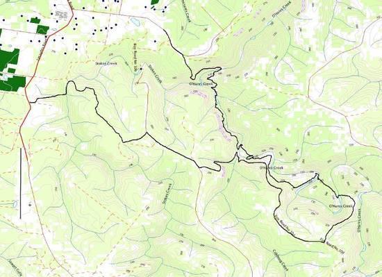
For example here is a GPS track overlay on the Appin 1:25,000 map:
Also, I believe that Memory-Map has it's own proprietary format and does not like to play with other programs (note it is not listed on the GPSOZ site as compatible maps for Oziexplorer), something to think about.
I hope I haven't confused you with too much information, please feel free to ask more questions.
Cheers,
Michael.
Thru my hiking experience iv found the MSR MIOX Purifier to be the best option, at 99g it dus all I need plus more. only down side is sediment left behind. I get passed this with a hat… used as a basic sediment filter. A little taste is left but i have yet to have any issues with it.
Hello,
Just found this forum and I must say it is very interesting.
I live in Mandurah, Western Australia and have only really considered lightweight hiking in the last few months. Have already made quite a few changes to my pack although far from going properly ultralight to the extreme like many others, I am finding.
I mainly hike along the Bibbulmum Track which is pretty awesome, doing the Overland Track in Tasmania in November/December, can't wait!
Cheers,
Will
Hi Will,
Welcome to the group both this forum and UL hiking.
Resurected an old thread there :)
Im up in Perth, and walk the Bib track most of the time too. I maintain the trail and shelter from White Horse Hills to the Hwy.
See you out there some time perhaps.
Cheers
Mark
Become a member to post in the forums.
 New Ultralight GearSee the latest releases in ultralight cottage-brand gear from small makers.
 Loading...