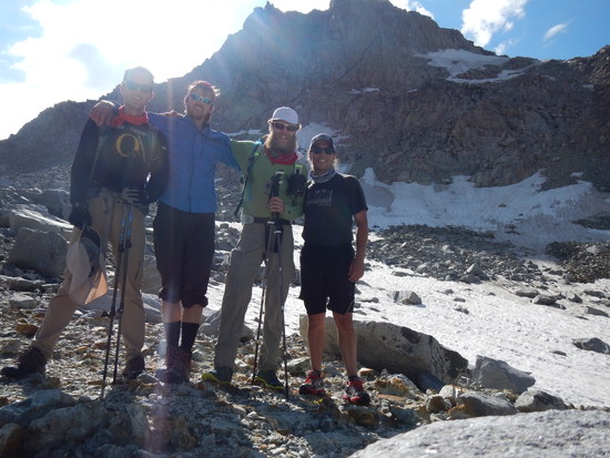
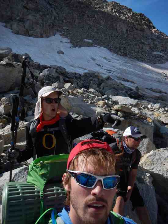
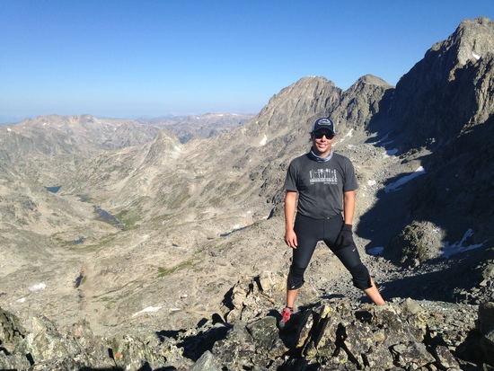
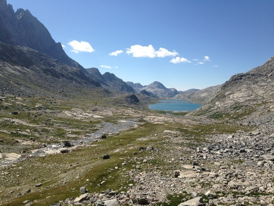
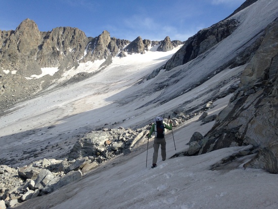
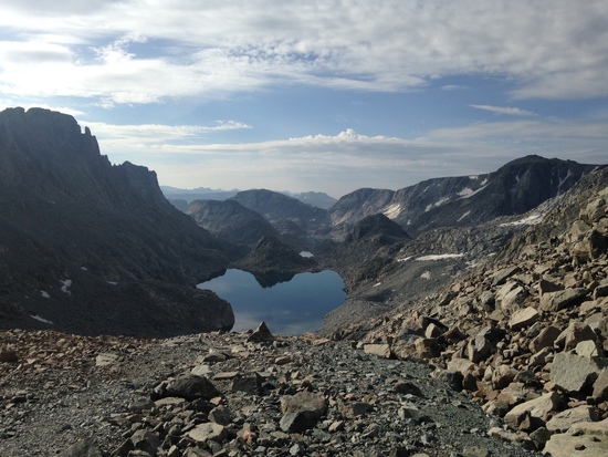
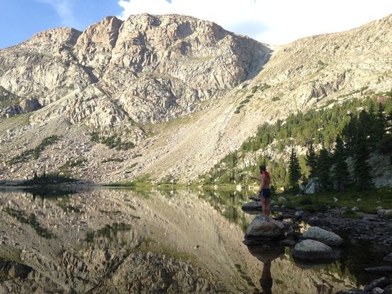
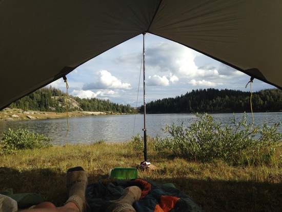
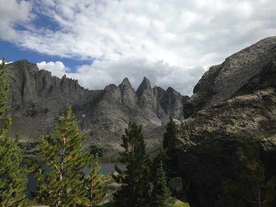
Our planned route: http://www.adventurealan.com/WRHR/index.htm TL;DR at the bottom 3 pretty green companions and I drove from Minneapolis, MN to Pinedale, WY. After picking up some last minute supplies and a fishing licence at the Great Outdoor Shop, we drove to the Green River Lakes Campground north of town. After a thorough pounding to my car's suspension on the long, pot-holed gravel road, we divided the shared gear and food, and tucked ourselves in for an early departure the following morning. Sunday August 9, 5:45a: We wake up to a fog drifting just above our campsite. After a hearty meal of hard-boiled egg burritos, we collect our things and head out from the trailhead. The vertical granite face of squaretop mountain was obscured by butts, but the top was lit up by the bright morning sun. Walking on the well-used trails up to our first pass was easy, we averaged a relaxed 3.1 mph when walking. Cube pass was difficult, but not as difficult was what was to come. We had a couple shadows for the hike up, but we selected a campsite on the far side of peak lake. The two other groups camping at the lake were also attempting the Alan Dixon WRHR. Monday: We broke camp at 7a and began the hike to Knapsack Col. Mountain passes and scrambling up talus are new endeavors for everyone in our group, including me. This pass was difficult, but was a great intro to what we would soon encounter. Loose, small talus at the very top of the pass, made the final push tough. We took the wrong line on the descent and slowly descended on the steep snowfield. A better line can be made by crossing along the contour line to the north and then descending on rock. Once at the bottom, I was thrilled to run, jump, skip and frolic over the large, stable talus. Water rushes under many of the rocks, making slow drop into Titcomb basin absolutely delicious. Once in the basin, we hiked easily to the far lake, and quickly dipped to cool of over lunch. Our shadows group caught up with us just as we continued up to Indian Basin, but we did not see them again. The trail up to the Indian Basin is easy to lose if you are not constantly watching the terrain. The trail is hard, and pretty steep all the way to the top of Indian Pass. Drink lots of water and take frequent brakes to give yourself a chance to catch up. It was our second day at altitude, and I had not yet adapted to the thin air. Knife Point Glacier is very different from the USGS maps. From the top of the pass, one can travel almost directly SW over the glacier to the talus below Alpine Pass without difficulty. Being novices with route-finding and glacier travel, I took a slow, bad line–it meant added time and energy spent. We found ourselves stuck at the same bivies-only rock(s) at the base of Alpine Pass at around 4p. After much debate about going over Alpine Pass, we were lucky to choose to wait until morning. I had not watched my water intake, and quickly found myself feeling ill once idle. Tuesday: After a night under the stars, listening to rocks crashing down the steep part of Knife Point Glacier, we rose and headed up the pass. A lone hiker joined us for our ascent of the large, steep talus. Though likely 30+ years older than us, our inexperience became clear when he unhesitatingly tackled the climb faster than all of us without letting the trekking poles out of his hands. The grey, overcast morning did not make the difficult traverse of Alpine Lakes any easier. After ascending and descending the hardest pass, we had to cover 2-3 miles of very large, sharp talus to the outlet of the lakes. If you can, pick a higher line along the west side of the lakes–as it will likely be easier than some of the Class 3-4 scrambling we had to do to get past obstacles near the shore. Unless the line we picked was significantly harder than what Alan Dixon encountered, this is more difficult than the Class 4 climbing noted for later in the day. Staying higher might have allowed us to see a better line. Finally things became more level (but still only talus) as we descended to the lake south of a mountain called "The Fortress". This was my favorite lake we encountered. A deep aqua in color, and stunning below the steep talus on 3 sides. Two of my companions took the longer route around the south side, while Chris and I chose the northern side with the short climb expected. The slot was easy to find, and easy to approach as you could see it the general location from far away. The climb itself was only 2 (if not 1) section where you need to climb up 5 feet to a flat section from below. There is a friendly 'jug' hold to get you there. We passed up our packs, but this was likely not necessary as our packs were quite light. After the first one, sliding to your left will present an easy scramble up to the top of the bench stretching out below The Fortress. The route around the south side of the lake only took 15 minutes longer, but it involved some wading to avoid a longer climb up/down to avoid a steep section. 600 feet below is Camp lake, accessed by some good route planning, and sliding down some granite. Keep an eye on your pack's bottom–Andrew's tent poles put some holes through his Osprey. Another 600 feet up and 600 feet down was our campsite at Upper Golden Lake. Wednesday: Much to my frustration, we decided to err from the planned route. Andrew was not comfortable traversing so much talus. We followed the Hay Pass trail to the Fremont trail, stopping for lunch at one of the Pipestone Lakes. After catching and releasing a 12" cutthroat, we continued the on-trail travel to Sandpoint Lake. The walking from Hay Pass to our campsite seemed incredibly easy after the difficulty on the previous days. However, much of this trail deviates from the steep, granite mountains–the huge scenery we had grown accustomed to was missed. It also meant sharing the trail with pack horses (and the accompanying waste) I caught 4 or 5 brook trout while we were camped. Thursday: I convinced the group that we should meet up with our original plan and camp behind the Cirque of the Towers. Again, the trail was easy, and finally began to bring us back to the granite behemoths to the east. We finally received some rain, but when it moved on 3 minutes after it started, we would not see it again. Shadow Lake was very busy, but we found a nice spot on the SW side. It was a little windy to catch trout when I went out with my tenkara rod, but later in the evening there was more activity, but I was too tired to fish. Friday: We split up into two groups. Anders and I went over Texas Pass into the Cirque, while Andrew and Chris backtracked 2 miles, and followed a well-used trail past Dad's lake to Big Sandy. Texas Pass was a breeze compared to Alpine Pass–cairns abound, and there was almost a steep gravel path in some places. Despite our initial hike through and around beautiful steep granite in the north, the Cirque still managed to impress us. We lost the trail we needed going around the west side of Lonesome Lake, but some scrambling got us back up to Jackass Pass trail. Being a Friday meant we saw plenty of hikers and climbers coming up the eroded trail. We would probably have made better time if we had been hiking down a steep talus field than navigating the exposed rocks and steep, sandy runoff that comprised the trail to Big Sandy Lake. The final hike out from the Lake was fast, easy, and downhill. Our car had been shuttled to the trailhead (but not as expected–more below). When Chris and Andrew got out just before noon–our car was there, but the keys had been locked into the car. They hitched a ride to Pinedale and called to sort it out. A tow truck was already en route to get the keys out. However, when Anders and I found the car (with the key in the agreed location), we thought Andrew and Chris hadn't made it off trail yet. After about 5 hours, we jokingly assumed that they were stuck in a crevasse and we went to set up our shelter. It was then that we realized that there was a small white piece of paper under the windshield wiper. It explained what had happened, so Anders and I hit the (TERRIBLE) road to meet them in Pinedale. TL;DR – The Wind River Range was beautiful while we were there August 9-14. The steep granite is cold, hard, and unforgiving, but absolutely stunning at each turn, and over every pass. That said, the high route is not easy. While I made efforts to forewarn my companions about the route's difficulty, not all of us were comfortable with the challenges. If your balance isn't the best, or you are uncomfortable climbing on steep rocks or scrambling in general, this route will be tough. Plan for more time to cover the tough parts–especially Alpine Lakes (5 straight hours on steep and rough talus, plus more later in the day). That said, I found every challenge to be well rewarded by starkly beautiful scenery–different in each basin. The perfect Titcomb lakes, the alien looking Alpine lakes, the lush Golden Lakes, and the impossible spires in Cirque were each uniquely spectacular. Some notes–If I were to attempt the route again, I would camp in Indian Basin on the second day. While on the one hand, it makes the third day a little harder with Indian Pass, Knife Point Glacier, and Alpine Pass/Lakes all in succession, staying at the base of Alpine Lakes is not ideal. We were lucky with the weather sleeping out on the rocks, and continuing over the pass would not have resulted in better camping. I brought a trailstar, since I was uncomfortable trusting just a cuben tarp. We were never tested by strong weather, so I certainly could have stuck with the tarp–and probably will for the next time I'm in the Winds. We brought a compass, but it was redundant since we had a phone with GPS/maps. As I quickly learned (in more ways than one), granite is an unforgiving substance. Hours on sharp talus resulted in very sore feet. I was wearing Inov-8 TrailRoc 245 shoes (which have a light rock plate), but I might be inclined to use a shoe with more substantial protection in the sole. My feet were never in pain–just sore. I would prefer to avoid the crowds at Shadow Lake, so I would have camped closer to Texas Pass–or in the Cirque if plans allowed. The roads in and out of the trail heads are absolutely terrible. I was close to needed new struts before the trip, but definitely needed them afterwards. Wind River Brewing Co. is OK. The beer is good, but the service is slow. We had planned to go to Lander, WY on Saturday, but opted for Cheyenne to get a little closer to home. Steamboat's Steak and Smoke House was everything we wanted. Link to Gear List https://docs.google.com/spreadsheets/d/1tI22f4bxkRzzYl1OFDufRgwdb4597FJS5wu58ulW1gg/edit?usp=sharing Photos 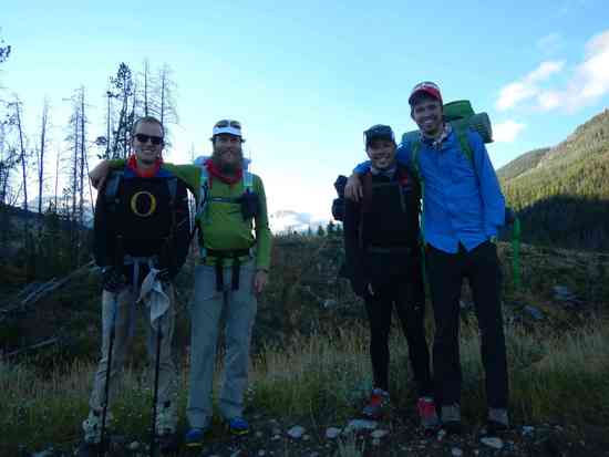
Topic
Wind River Range — Green River Lakes to Big Sandy, mostly on the Alan Dixon proposed High Route
Become a member to post in the forums.
- This topic is empty.
Looks like a great time! Surprised that the road to Big Sandy TH was bad. It was nice 2 years ago. But who knows how often they grade the roads. Or how hard recent rains may have been. I'm hoping to do the WRHR in a few years when a buddy re-retires. Can you elaborate on the balance issue thing? I do have a balance disorder and I do go into steep terrain but am very careful and try to avoid being in a position where I could get seriously hurt or killed if I lost my balance. Would you classify any of the terrain you covered like that? Thanks.
Interesting to read someone else's opinion and trip report; we did this last week – fine route.
Sounds like you had a great trip! What were the bugs like?
Trivial last week.
Thanks. I am headed out next Friday to the Winds going in at Dubois (glacier trail) and coming out at Big Sandy travel mostly off trail.
Our week, there were nearly no mosquitoes to be found. And those that were around were not biting. It was quite odd. It likely varies from week to week. Lack of moisture while we were hiking may have helped to keep the mosquitoes at bay.
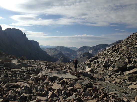
Well–the road up to the turn-off into the trailhead was good, but then the long 10+ mile road after that was terrible. My hatchback could have gotten stuck in some of the pothole if we were not careful. Balance issues–I think it depends on how comfortable you are picking your way from boulder to boulder or how much experience you have ascending/descending on talus. My companion was managing it just fine–I think the main issue was that he was not enjoying the challenge. It sounds like you're comfortable with very rough terrain–I don't think you would have too much trouble. The toughest part is the entire Alpine Lakes stretch. It is 2 miles of navigating HUGE talus (1/2 to full VW Beetle sized), often on a fairly steep off-camber incline. It's followed by another mile+ of level talus before you get back to dirt and bedrock. Besides the challenge of the terrain itself, fatigue plays a roll as you make your way to the outlet. Again, while it was a challenge to negotiate the rocks, taking one's time and going slowly to match your skill/comfort level is key. There are two or three tough spots that I noted in the report–sections where you have to climb high enough to get past some slick cliffs. We picked a bad route(s) to approach the points where the cliffs can be passed, and staying higher is probably better. Since we missed two days of the route, I can't speak for the Europe Canyon / Bonneville Basin areas, but judging by the contours and other reports, Alpine Lakes has the roughest and steepest terrain. There are more mountain passes over talus, but it won't be as steep or fatiguing. Here are a few more photos–the large rocks we're sitting on are on the small size of the talus you'd encounter at Alpine Lakes. The second gives a visual perspective on the terrain below in Alpine Lakes. There's another photo in my first post that shows the steepness of talus to the right of the first lake. 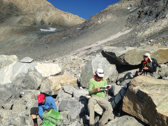
The unnamed pass out of Bonneville Basin is great going out…..but has a stack of tedious xl talus on the other side…
Thanks Adrian. I think it sounds like I'll be fine. Last year we went form Middle Lake to Europe Canyon by way of Hall's lake. That part is really easy. We're heading up to Hays Pass/Golden Lakes/Milky Lakes/Europe Canyon in 2 weeks so we'll see some more of that area and the WRHR. Can't wait.
Have fun! I can't wait to go back to the WRR myself…
A few years back I carried an Alpacka Scout and paddled through the lakes to avoid the talus. If you aren't comfortable on the rocks or travel solo as I do, I'd recommend packing a raft for this section.
Nice report, but I see soap on your gear list. Shame on you. Art
Good job, everyone! This thing is getting popular. And Adrian, while you missed some parts you def did the best, highest and most challenging section! Going in the opposite direction of the OP on August 6-11, my wife, kid, dog and I did the complete route. While presenting us with strenuous hiking and long days, we found no significant technical hurdles. The route description on Alan's site is very accurate, the maps precise and the anecdotal advice helpful. The Wind River High Route comes from me with a high recommendation to fit backpackers with a knack for boulder hopping. I posted a full TR to my friends over on this site, mostly because their image representation is better than BPL: http://backcountrypost.com/threads/wind-river-high-route.5020/ 


Glad to hear you had a successful trip. How was the pup on the talus? I have a German Shorthaired Pointer who has more energy than is good for him. While I'd bet he'd be able to handle some of the rocks, I'm worried he'd go too fast. Otherwise, as long as I keep him from sprinting himself to exhaustion, he can go all day for a long time.
I would hesitate to recommend this route to dogs, only because of the long stretches of large talus as you point out. That said, our McNab sheep dog had absolutely no issues, even carrying a pack. Like with any other backcountry partner, if you know them well you probably can judge fairly accurately if certain challenges are appropriate.
Thanks Jan. It's good to hear your thoughts.
Become a member to post in the forums.
 33% off home freeze dryersMore nutritious, better flavor, custom meals.