Topic

Rae Lakes Loop walk up permit likelihood, water situation, mosquitoes

  • This topic is empty.
Viewing 14 posts - 1 through 14 (of 14 total)
Don Burton BPL Member
PostedJul 6, 2015 at 4:35 pm

I applied for a permit for 2 different days within the next month. They were 2 of the days that still had permits available and I faxed in the app. If I don't get a permit, what is the likelihood of getting a walk up permit? I was thinking of driving up the afternoon before, car camping and getting in line at ranger's office at 5am the next day. Should that work? Is there car camping nearby? How many people should I expect to get the permit for?

Also, if anyone has been up there recently, what is the water situation? Mosquitoes?

Thanks in advance.

Adam White BPL Member
PostedJul 7, 2015 at 2:44 pm

Are you going solo?

If so, the odds that you’ll get your permit on one of your chosen days are very, very good. Especially if you’re willing to go either direction.

The SEKI website says you can pick up permits at 1:00pm the day prior. You might call them and ask if you can get a walk-up permit at 1:00pm for the following day (actually, maybe a knowledgeable BPL’er will chime in). If you can have one issued the day before, your plan will be pretty foolproof.

Yes, there’s car camping near the trailhead. See here: http://www.nps.gov/seki/planyourvisit/campgrounds.htm. Scroll down to Cedar Grove area–those are your options.

If you’re arriving on a non-Friday or Saturday, my guess is there will be camping available at those.

I was up there yesterday. Water is ample–nothing was dry. I think I saw a total of three mosquitos–I wore shorts and didn’t apply DEET. I carried a head net that I never used.

Don Burton BPL Member
PostedJul 8, 2015 at 2:27 pm

Adam

Thanks for the info. inwas surprised to receive a call from a wilderness rep saying I didn't get a permit. I got a chance to ask a few questions and he confirmed what Adam said about getting a walk up permit at 1pm the day before. He also said that I'd probably be able to get one. I may go solo. It just depends on which of my friends are free.

Don

Don Burton BPL Member
PostedJul 13, 2015 at 3:35 pm

I've got my schedule but I'm wanted to know what people think of camping at Vidette Meadow or Junction Meadow? One over the other?

Here's my schedule. Please let me know if anyone sees any red flags. Solo trip.

July 27: Early start. Road's End to Woods Creek Crossing
July 28: Woods Creek to either Vidette Meadow or Junction Meadow
July: from either Vidette or Junction to Road's End.

Hikin’ Jim BPL Member
PostedJul 15, 2015 at 2:47 pm

Don,

I did the Rae Lakes loop last year. Your overall itinerary looks fine and is perfectly workable. One comment: The ascent up Woods Creek is actually pretty moderate. I’m betting that you could get up to the confluence with Baxter Creek without too much trouble given an early start.

The next day, going over Glenn Pass, is quite a bit more difficult. Yes, the net elevation change isn’t that much more (~3600′ from Woods Creek Crossing to Glenn Pass vs. ~3000′ from Zumwalt Mdws to Woods Creek Crossing), but it comes sort of all at once as you pass upper Rae Lakes, and it’s at quite a bit higher elevation (nearly 12,000′ at the top of Glenn Pass).

So, I think both because the trek up Woods Creek is relatively moderate AND because the schelp over Glenn Pass is more difficult, I’d do more the first day and a bit less the second. That’s me.

As for Junction vs. Vidette, I’d play it by ear, but generally Junction puts you in a better position to get out early on your last day.

Just my thoughts. Probably great any way you do it.

HJ
Adventures In Stoving
Hikin’ Jim’s Blog

Adam White BPL Member
PostedJul 15, 2015 at 9:54 pm

Seems completely workable. I've done the loop a few times, most recently in a single day (this was last week–I posted a trip report in the trip reports forum, if you're interested in more details).

My $0.02 on your trip:

I would probably stick with Day 1. It's a 15.5 mile day or so with 5,000 feet of climbing. For many, that's a pretty full day. Plus, if you're coming up from sea level, 8,500 ft is a pretty good place to spend the first night. The risk of any altitude issues is pretty low.

I'll call yours TRIP A. The following are alternatives I'd consider for the next two nights:

TRIP B
Day 2: Ascend to Rae Lakes, then enter Sixty Lake Basin. Explore Sixty Lake Basin, then exit, to camp at Rae Lakes. This will amount to about 14.3 miles, and +4,100 ft, -2,000 ft. In other words, easier than Day 1 in every sense. This allows you to explore Sixty Lake Basin (which is spectacular), take in views of the Rae Lakes trail from the Sixty Lake Basin trail (also spectacular), and spend more time in Rae Lakes (one of the highlights of the loop).
Day 3: Rae Lakes, over Glen, to Road's End. This is a slightly harder Day 3, but your pack will be lighter, and you'll have your "trail legs". 18.6 miles, +1,700 feet / -7,300 feet.

TRIP C
Day 2: Ascend to Rae Lakes, ascend Glen Pass, descend to Junction Meadow, and ascend to East Lake. East Lake (and Lake Reflection, if you have more miles in you) are highlights that are so frequently missed on this loop. Google image search "East Lake Kings Canyon" for a sense of this. Day 2 is now 17.7 miles with +5,254 feet / -4,293 feet, which shouldn't scare you after Day 1.
Day 3: Simple descent to Road's End. I didn't bother looking up the numbers–it'll be quick.

If you're unfamiliar with Sixty Lake Basin or East Lake, I can send links to maps, but they're both on Tom Harrison maps, NPS maps, and the USGS quads, so I suspect (hope) you can find them.

Lastly, if you're uninterested in the options above, I'll give you my opinion regarding your original question:

Both are fine. If you want to get out quicker, descend to Junction Meadow. Otherwise, I think Vidette is a little more scenic.

Hikin’ Jim BPL Member
PostedJul 16, 2015 at 10:31 am

I would probably stick with Day 1. It’s a 15.5 mile day or so with 5,000 feet of climbing. For many, that’s a pretty full day. Plus, if you’re coming up from sea level, 8,500 ft is a pretty good place to spend the first night. The risk of any altitude issues is pretty low.

Adam, are you sure that’s 5,000 feet of climb.

As I look at a topo map of the route, my read is that the trailhead is at about 5,000′ and Woods Creek Crossing is at about 8,500′. Isn’t that a 3,500′ difference?

I definitely agree that it’s better to sleep below 9,000′ on one’s first night.

HJ
Adventures In Stoving
Hikin’ Jim’s Blog

Pedestrian BPL Member
PostedJul 16, 2015 at 11:42 am

>>As I look at a topo map of the route, my read is that the trailhead is at about 5,000' and >>Woods Creek Crossing is at about 8,500'. Isn't that a 3,500' difference?

Two different numbers:

Net elevation gain/loss (3500 ft, here) = Elevation of destination – Elevation of Start

TOTAL elevation gain/loss (5000 ft quoted by Adam) = All the little ups AND downs; most trails never go steadily up or steadily down or stay strictly flat…

To a hiker, it is the Total Elevation gain that matters. I think you'll agree ;).

Perhaps that explains the difference; I haven't looked at the trail in question.

Hikin’ Jim BPL Member
PostedJul 16, 2015 at 1:04 pm

To a hiker, it is the Total Elevation gain that matters.

Yeah. Definitely agree. But on this trail, you’re following first a river (S Fork Kings) and then a tributary (Woods Cr). It’s got some up and down, but I don’t think there’s 1500′ of up and down in there, not to my memory anyway. I suspect Adam was just reciting from memory. If his memory is anything like mine, occasionally the wrong number pops up.

I guess my point is that Day 1 doesn’t have a lot of gain and that it might be possible to go a bit farther since Day 1 is to my mind relatively easy. Each to his or her own/HYOH. :)

HJ
Adventures In Stoving
Hikin’ Jim’s Blog

Adam White BPL Member
PostedJul 16, 2015 at 9:53 pm

> Yeah. Definitely agree. But on this trail, you're following first a river (S Fork Kings)
> and then a tributary (Woods Cr). It's got some up and down, but I don't think there's
> 1500' of up and down in there, not to my memory anyway. I suspect Adam was just
> reciting from memory. If his memory is anything like mine, occasionally the wrong
> number pops up.

Well, I wanted to be able to say that I calculated the net elevation change with Sierra Mapper–that's what I intended to do–but I think I took the wrong Woods Creek Crossing off the Sierra Mapper profile.

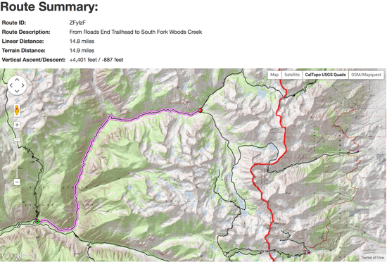
The calculated Sierra Mapper profile for the segment between Road's End and Wood's Creek Crossing is below.
toWoodsCreek
That predicts 14.9 miles, and +4,401 feet / -887 feet. This is less than 5k feet, of course! I think 887 feet of descent along that segment does seem reasonable–the trail is pretty roller-coaster-y between Wood's Creek and Upper Paradise. So, 4,400 feet of climbing seems pretty accurate.

Jim, my memory is a lot like yours. What are we talking about here again ;)?

Adam White BPL Member
PostedJul 16, 2015 at 10:11 pm

Aaron,

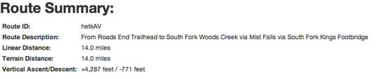
Unfortunately, I have to admit that I have updated trail information that I'm running in an (as yet, not-for-much-longer) unreleased version of Sierra Mapper. This was based, in part, on GPS information I gathered on my recent Rae in a Dae hike. Below is the output for that section (same as in post above):
toWoodsCreek

I've been on travel, and need to visit my desktop at home to make the update to the Sierra Mapper servers…

But I wholly support your method of calculating it ;).

Don Burton BPL Member
PostedJul 17, 2015 at 12:12 am

Thanks for all of the great info. It gives me some things to decide before leaving. I'll be going solo. Getting a walk up permit Sunday July 26 and hiking mon-wed. I like the sound of the different routes. I will have to see how I feel. Cardio and strength wise I feel great but I've recently had issues with my knees. I had my first doc appt today. From my research and my appt it sounds like over stressing the IT bands. If they feel good, I probably will push on to one of the alternative routes.

Viewing 14 posts - 1 through 14 (of 14 total)
Loading...