Here's my TR from another forum:
Pemi Loop
I've wanted to do this hike for a few years now, but various extreme weather events kept me away. I had last week off, though, and with a nice weather window I was off. People have done this hike in 20 hrs apparently, but I wanted a nice, unhurried trip. I planned for 4 days. As we all know, it's a lot easier reading about a hike on your laptop, sitting on a couch, than actually doing it; and never having hiked in the Whites I wasn't sure what to expect. I drove up to Lincoln on Sunday, had a real good dinner (Gypsy Cafe-great local spot), and started walking Monday morning. I was doing a clockwise loop, so I crossed the East Branch of the Pemigawasset River on the suspension bridge and started on the flat, wide Lincoln Woods Trail. 1.4 miles in I turned onto the Osseo Trail and began to ascend. I had heard that there were ladders on some of the steeper parts, but these turned out to be actual staircases! I summited Mt Flume, and then Mt Liberty, then made my way down to the Liberty Spring Tentsite. All of the AMC campsites in the Pemi have a spring, bear boxes, a composting privy, and tent platforms as there are very few level spots. I have a non-freestanding tent, but with a bit of fiddling was able to set it up using some small screw eyes I had brought.
My next section of trail was part of the AT, and as you can see, there were no more staircases. I would now be on the Franconia Ridge Trail, a really spectacular, above treeline path all along the ridge to Mt Lafayette. Lots of folks out, lots of kids too, all enjoying the dramatic views. Past Lafayette was the Garfield Ridge trail, with steep, rocky downs and ups to Mt Garfield. Views from the summits were awesome. Very easy place to run out of superlatives. Second night I stayed at the Garfield Ridge Campsite, and met several AT thruhikers.
Started the next morning with a crazy steep descent; rocky and right in the middle of a stream. Then up to Galehead Hut where I stopped for a glass of lemonade. The next section of trail, now the Twinway, was billed as the hardest part of the loop. The trail gains 1122 ft of elevation in .8 miles, steep, rocky and relentless. I was very happy to see the summit cairn. I had seen the forecast posted at the Galehead Hut which called for thunderstorms, but I was able to make it to the Guyot Campsite by about 3:00, traveling on a very pretty above treeline section, past Mt Guyot. The caretaker asked if I would stay in the shelter, as my tent takes up a whole small platform, and he wanted to leave room for late arrivals. But it was a good call, as it started to rain and thunder about 5:30, and rained much of the night. We had a bunch of nice people in the shelter, and close by was the cooking area by the bear boxes covered with a tarp.
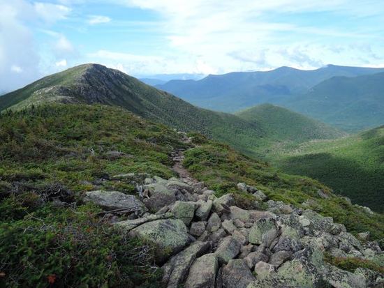
The final day was Mt Bond and Bondcliff. I think this was my favorite part. It's a less accessible and more secluded part of the Loop, with equally amazing summits. I had heard that the descent from Bondcliff was tricky, but there was just one easy scramble, and then a very pretty, gradual descent through the woods, with a couple of stream crossings. Then the flat, wide Wilderness Trail back to the lot.
This was a great solo hike. First time in the Whites, and I loved it. It was a very rugged loop; one of the gals in the bicycle club who hikes frequently here will often break off at the end of the ride to do 20 more miles. Now I know why! I met a bunch of nice folks on the trail and at the campsites, and contrary to a few recent posts on the forum, lots of young people were out, dayhiking and backpacking, outnumbering the old geezers like me. And as soon as I was in my car on the highway I felt a pull to go back to those summits. I will.