Topic
Early Season Trip in Yosemite – Mono Meadows to Red Peak Pass/Isberg Pass area
Forum Posting
A Membership is required to post in the forums. Login or become a member to post in the member forums!
Home › Forums › Campfire › Member Trip Reports › Early Season Trip in Yosemite – Mono Meadows to Red Peak Pass/Isberg Pass area
- This topic is empty.
-
AuthorPosts
-
May 30, 2015 at 4:34 pm #1329424
Edit: Date was 5/27/15-5/29/15.
Sierra Mapper route visualization:
http://awhite4777.pythonanywhere.com/SierraMapperAlpha/default/mapper/n346/n074/n068/n021/n008/n005/n003/n346I was itching for an early season trip and after a couple weeks of stormy, unsettled weather things finally cleared up and the forecast was for warm temps and stable weather. I was hoping to go from Happy Isles in Yosemite Valley up to Isberg Pass via Merced Lake, and possibly head all the way to Red's Meadow depending on conditions. With significant snow above 10k feet, and wet/muddy trail conditions I knew that this might be stretching it this early in the season, which it was.
When I arrived in Yosemite at about 4pm, I was unable to get a same day permit for HI so I settled for Mono Meadows TH, which is on Glacier Point rd. This meant that I had to go over Red Peak Pass to get to Isberg Pass, which added a few miles but meant I started at close to 7000 feet instead of 4000 feet. I went pretty light but not ultralight as I had to bring a bearcan, so I also brought a small stove, fuel canister, 2 freeze dried dinners and a enough bars and perpetuum powder for 2 long days plus a little extra just in case. My starting pack weight was about 18 lbs with food and water.
I started hiking at 6:30 pm and made it about 6 miles in before dark, camped and got up around 5am to see how far I could get in the 15 or so hours of daylight available this time of year. Shortly I passed what looked like a giant game of Jenga gone wrong about a million years ago:

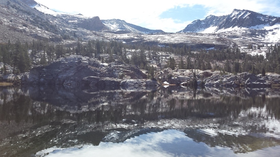
A lot of the initial portion was forested and pleasant but not the most scenic terrain. Eventually it opened up to more alpine environment and I stopped to snap a few pictures:
Aside from a wet crossing about 3 miles in the first night, I managed to keep my feet dry all the way to Red Peak pass. There was minimal snow on the south side of the pass as I went up to 11k feet. This is the view from the top looking down the south side:
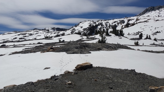
Going down the north side of the pass however was a different story – wet snow all the way from 11k down to 9500 or 9k feet.
From that point on wet snow and a bunch of wet stream crossings meant my feet were in varying stages of wetness pretty much the rest of the day. Approaching Isberg Pass in early afternoon, the snow got wetter, softer and deeper and the trail disappeared – the tracks I had followed down from Red Peak Pass did not go up to Isberg. The scenery was tremendous however – half frozen lakes, lots of snow, and only a few sets of footprints to indicate that anyone had been there recently.
Following the trail began to be difficult as it was nearly all under snow, and the footprints I had been following disappeared. This was my first time in this part of the park, so the terrain was unfamiliar. This combined with my less than ideal map (200 foot contour lines, etc) and my rather rusty navigational skills did not make me feel great about pushing on. At a point 2-3 miles from Isberg Pass I was in a beautiful, broad valley covered with snow and dotted with trees and tarns, surrounded with peaks and ridgline, with no idea which notch was the pass and no indication of where the trail might be.
On top of this it was 2pm, I was post-holing knee-deep and more in the wet, soft snow, making travel slow and potentially dangerous, and dark clouds were building over the ridgeline that I would have to cross.
I decided to turn around at this point, and headed back down to the junction that led to Merced Lake. Going back downhill for a change and getting out of the snow was nice. The trail by the river reminded me of Lyell Canyon quite a bit with its serene and meandering river with grassy meadows and hummocks.
Once below the snowline I was able to pick up the pace a bit and made it to Merced Lake around 6:30 pm. As you descend the Merced river drainage towards Merced Lake and Little Yosemite Valley, there are a number of impressive waterfalls, huge smooth granite slides and flumes/standing waves, and an impressive number of huge trees strew about the river like matchsticks. I had been through much of this section before and wanted to get to LYV before dark so I only took a few pictures.
I hadn't seen a single person all day, until I finally passed a guy headed up towards Merced Lake. I saw one more guy in a Montbell jacket who was camping near Echo Valley (I think) and we chatted briefly. I passed the spot where a falling tree nearly killed me on a windy morning almost exactly a year ago, and may have sped up a bit. Around 8:30 I got the headlamp out and by 9 or so I was pulling into Little Yosemite Valley. I texted my wife that I would be out in the morning and found a spot to crash in between all the half dome climbers, pretty happy with the 40 mile day that I had logged in somewhat wet/snowy conditions.
The next morning I slept in till around 6, got going pretty quickly and soon came across this perfect snow plant:
I hiked about 10 miles that morning, including a detour to Clark Point caused by missing my turn on the Panorama Trail just past Nevada Falls. I was at the car by 10:15 or so, and after a quick stop to snap yet another version of the iconic picture from Glacier Point Road's "Tunnel View"
I was home in the bay area by 4pm, in SF for my friend's SF premier of his film "Drawn" ( http://jercollins.com/ )at 6:30, and got home after midnight. Not bad for a quick hastily planned early season trip!
May 30, 2015 at 4:48 pm #2203397When did you go?
–B.G.–
May 30, 2015 at 4:49 pm #2203399I started this past Wednesday evening and finished Friday morning (5/27-5/29/15)
May 30, 2015 at 8:10 pm #2203425Nice trip Allen, thanks for sharing.
May 31, 2015 at 8:16 am #2203495Thanks Doug!
I just did some editing to make it more readable and descriptive, and put the pictures in with the text rather than all at the end.
Jun 1, 2015 at 12:14 am #2203711Allan,
Great trip report with lots of photos.
I have fond memories of Red Peak Pass….my 1st long trip going UL.
All that snow would have freaked me out as my navigation skills are horrible.
Thanks for taking the time to post up.
Tony
Jun 1, 2015 at 7:05 am #2203745I've seen that much snow in July.
billy
Jun 1, 2015 at 9:15 am #2203783Great report! I love this whole area of Yosemite, and the various trail/offtrail options in the Isberg/triple divide area. Unbelievable how you could do this at this time of year.
Many years ago I also came up towards Red Peak pass in snow on the north side and just couldn't figure out for sure where the pass was. I'd been postholing for a couple of miles and was tired. I knew that if I guessed wrong on the pass I'd be in a world of hurt, so I turned around.
You sure cover a lot of ground in a day…
Jun 1, 2015 at 11:48 am #2203826Looks like a good way to break in the 2015 season.
Jun 1, 2015 at 2:20 pm #2203863Thanks all! It was a fun trip and a good way to kick off the season for me. I thought I'd see a few more people, but it sure was quiet up there!
Jun 1, 2015 at 9:53 pm #2203987Snow plant! That's what those are called! Thank you!
I saw quite a few on my jaunt last weekend, and I wondered what it was really called. I came up with Satan's Phall–you know what? Nevermind.
Your photos make me realize that although we were only a few miles apart, we had quite different experiences. My trip was a beautiful, peaceful, easy walk in the woods…I wrote up a TR, but now it's a matter of massaging into BPL.
Thanks for taking the time to write it up!
-
AuthorPosts


- You must be logged in to reply to this topic.
Forum Posting
A Membership is required to post in the forums. Login or become a member to post in the member forums!
Our Community Posts are Moderated
Backpacking Light community posts are moderated and here to foster helpful and positive discussions about lightweight backpacking. Please be mindful of our values and boundaries and review our Community Guidelines prior to posting.
Get the Newsletter
Gear Research & Discovery Tools
- Browse our curated Gear Shop
- See the latest Gear Deals and Sales
- Our Recommendations
- Search for Gear on Sale with the Gear Finder
- Used Gear Swap
- Member Gear Reviews and BPL Gear Review Articles
- Browse by Gear Type or Brand.
