Humble as humbling; to experience wilderness in it’s wildest and vastest state is indeed a very humbling experience.
Since it’s inception, I’ve followed Dave’s Bob Marshall Open with great interest. The reports following each year’s event were ripe with much exuberation and much woe; enough exuberation you wanted to join in, enough woe you wanted to stay clear.
After observing from the sidelines, I decided it was time to jump in. Even though the vast majority of my trips into the wild are solo, my wife insisted that I partner up with someone for this endeavor, probably a good idea. I emailed numerous hiking and running partners and after first usually receiving very positive intentions of joining in, these were ultimately followed by rejection notices. No doubt a direct connection of them finally reading previous BMO trip reports (see the woe part above :) ). I finally resolved that I would do it solo until one evening my wife said there was someone at her work that was interested. I didn’t put much stock in it, as it was only a matter of time he would find the previous trip reports. As it turns out Kevin was still very interested, hmmm maybe this will workout. After several meetings and a few trail runs, we firmed it up- I have a partner. Kevin is a front of the pack ultra runner, so I knew his conditioning would not be an issue and would have plenty of experience with woe. He also has a strong background in whitewater rafting and kayaking and is an avid backcountry snowboarder. He had very little experience with multi-day backcountry travel, but that is where I could help out. As time ticked by, gear was selected and routes got firmed up. My wife I think was having second thoughts about teaming us up as she now had to hear about the Open at home and at work!
Two weeks out Kevin mentioned that he had a buddy that really wanted to join in, John. Again I couldn’t help be a little skeptical that John would come to his senses (read the trips reports) and bail. Not so. John is also a experienced and dedicated ultra runner, he also is an avid backcountry archer and knows about traveling through rough country. John is also very tech savy (his day job) and really helped with refining routes by using numerous online sources and melding them together. One night he treated us to a full route fly over via google earth that would prove very beneficial. It was set we would be a team of three.
Kevin’s in-laws have a cabin nearby Holland Lake, so lodging the night before was taken care. We shuttled a truck to Swift Reservoir and made the long trip to the Swan Valley. It was great to meet all the participants at the Hungry Bear Friday night. I was looking forward to meeting Dave as we missed each other twice, once on a three day snowshoe trip I had to bail and once on a trail race in Bozeman that he had to bail. After a big pizza, a few beers and some great conversation, it was time to turn in and get a good nights sleep (as much as a good night sleep as one can expect on the night before such a trip).
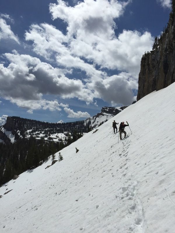
After a short get together in the morning, we were off promptly at 8:00. Everyone shared the same trail to begin with, but within 5 miles (Upper Holland), folks started peeling off. We were headed for Gordon Pass and ultimately Gordon Ck all the way to the South Fork and utilizing the pack bridge at Big Prairie. Our original plan was to use Holbrook Ck (via Pendant Pass) and ford the South Fork near White River. Everything looked good for that route watching the South Fork gauging station stay flat for several weeks until just a few days prior, we watched it starting to ramp upwards rather quickly. None of us were very keen on a dangerous swim, so we decided to eat 8-ish miles and use the pack bridge at Big Prairie. We made good time up to Upper Holland, but soon that slowed as we hit deep snow above the lake, it also started to rain. Route finding was a little troublesome in spots, but we got up to the pass without too much fuss. Our descent down Gordon Ck was pretty uneventful, the rain had quit which was nice. I will note that Gordon Ck held more grizzly sign than any other we visited (but will also note that we found some grizzly sign in every drainage we went through).
We decided to eat supper on the banks of the S Fork. As we ate we discussed our good decision in skipping the ford at the White, the river was rolling pretty well. We bumped into the Big Fork guys at Big Prairie, they were also headed for the White. We ended traveling another 5-ish miles to a nice bench above White River Park, we had hiked roughly an hour in the dark and we were ready for some shuteye. We woke early and decided to eat breakfast on the banks of the White, roughly a mile down the trail. We saw the Big Fork guys again, they were bivied up next to the park. A quick breakfast and we were headed up the White, we elected to use the east side trail (not on all maps) to avoid fording the White, which was rolling plenty good. We soaked in some gorgeous views, highlighted by Needle Falls, truly a impressive sight (and sound!). We had to ford the White up higher, but even at that it was no piece of cake, I would not have wanted to ford the crossing near the S Fork. At Brushy Park the White became very braided and it was tough to know where the trail ended and a braid began, but eventually we made it back to the east side and started headed up Juliet Ck for Wall Ck Pass. The pass offered up some nice views and also more snow. We dropped into Wall Ck following tracks (probably the other Helena group and possibly Tanner too?). As we followed the tracks we got deeper into the drainage itself, although the snow made it relatively going. Knowing the USFS would put a trail directly in the drainage we checked map and gps and sure enough the trail was above us. After a pretty good climb we eventually found the trail or I should say a trail. The going was getting a little tougher as the snow started to soften and we started breaking through more often. After peeking at the gps we decided we weren’t on the correct trail and went searching for the right one. Two hours later after wading through much blowdown and deep snow, we decided to give up and just follow the creek down, knowing that eventually it would hook up with the trail. We eventually found an old trail (I’d guess abandoned 20-30 years ago), that soon bumped into the actual trail. As it turned out we were on the correct trail to begin with, the FS had rerouted many years ago, but the addition never made it to the USGS- lesson learned!
Near dark we finally reached the Spotted Bear, the ford there wasn’t too bad (sounds like downstream it was) and soon Pentagon cabin where we spent night two. We found that no matter how sore/beat we were at night, we were always better in the morning, this morning being no exception. A quick breakfast and we were on our way. Our destination was Switchback Pass. This part of the route had given us some angst as we knew it would hold snow, especially the north side. We made pretty good time heading up, even after we hit the snow as it was still firm enough to hold us. Near the pass we spied two different pine martens, one apparently in hot pursuit of an unlucky squirrel. When we reached the pass the trail was gone. We knew we need to get to Dean Lake to pick the trail up, we decided to to head directly to Dean Lake, in hindsight it may have been better to drop down to the shelf below and then climb up to the lake. It definitely would have been less terrifying! After finding Dean Lake the trail was no easier to pick up; we almost made a grave error and followed a bit of trail (replete with log cutting) into Clack Creek. Luckily John was on his game and kept us out. We kept following one small finger after another, eventually petering out and dropping sharply into Clack Ck. We spent a lot time trying to find the right spot to drop off, knowing that the wrong spot would lead us into a jackpot. Even though we were dropping elevation, the snow remained making the going very tough. We were tiring quickly, but after a bit of good navigating and a bit of good luck we found where the trail dropped off and hit a series of short and steep switchbacks. Drop off on either side and not hitting those switchbacks and it would have been hell!
We made it to the Middle Fork where the ford (actually two) were a little dicy, but doable. I almost put on a heck of a show falling off a log jam trying to avoid the second ford! Gooseberry Cabin brought back some fond memories for me as I worked there some 27 years ago, the cabin still looked exactly the same, the area didn’t- the entire area had burned leaving a very large swatch of dead standing timber. We had some really tough trail between Gooseberry and Gateway Gorge, lots and I mean lots of blow down. This slowed an already slow pace. The thoughts of finishing in under 72 hours were slipping away. We stopped for a much need break and cooked supper (this stopping for supper before camp was a great strategy as it gave us much needed calories, a much needed break, a big morale boost and avoided cooking near our camp which helps keep Mr Griz walking down the trail). We were still 18 miles give or take from Swift and only had an hour of light left. We bantered back and forth about pushing though the dark to the finish. Kevin brought us to our senses with some simple math and calculated we would arrive at about 3:00 AM, that thought made the decision easy to push until dark and camp near Sabido cabin, leaving us ~ 16 miles the next day. Gateway Gorge in the evening sun was gorgeous. We marveled at the near perfect switchbacks on the other side of the gorge, but couldn’t spy it’s engineers.
We found a nice park to make what would be our last camp. This was our shortest mileage day (30), but probably our toughest day- no doubt about it we were beat and beat good. After a nice hot breakfast and some coffee, we were off. Big River Meadows was beautiful, but the trails were a combination of mud and undulating large humps of snow. John pointed out how bad it would have been to do this stretch on tired legs, Kevin muttered he would have simply stopped and cried :) Another good decision had been made. Once over Gateway Pass, the conditions didn’t improve much- lots of mud, but at least the snow was gone. Not only would this have been excruciating doing this stretch the night earlier, we would have missed out on some wonderful views- the South Fork of Birch Creek yielded lots of magnificent sights.
Eventually Swift would reveal itself, but held some challenges of it’s own- the mud hadn’t subsided much for one, but the trail wasn’t laid out for a leisurely stroll along the reservoir, it climbed numerous times up and down. The cold beer waiting at the truck was a good motivator to keep us going. At 1:30 we finally got to taste those beers and share one w/ Dave who was waiting for M to pick him up. It was nice to share our adventures with Dave and his with us, a great ending to a great trip.
To everyone who has finished or attempted the BMO, my hat is off to you. No one but a few will know how truly challenging and how truly rewarding such an adventure is. I’m pretty sure there are a couple of Helena guys that will be looking forward to next year.