Topic

Dayhikes before Big SEKI Loop

  • This topic is empty.
Viewing 19 posts - 1 through 19 (of 19 total)
Theo Diekmann BPL Member
PostedApr 14, 2015 at 3:45 pm

Hello fellow hikers,

As my year abroad in California is coming to an end in July, I am planning vacation in August. I stumbled accross the Big SEKI Loop and quickly grew quite convinced that I want to tackle this trail. In the comparison of the JMT and the BSL in her thread, Amy writes that certain beautiful portions of the JMT can also be explored via day hikes. Also in her thread, I found a discussion about medicine for tackling altitude sickness, which got me a little worried since I pretty much live at sealevel right now.

So I thought "Why not kill two birds with one stone and do some dayhikes to see some more of the Sierra and acclimate at the same time?".
My idea is to arrive in the Sierra with all my stuff for the BSL plus a small summit pack, stay at some campground for 2-4 nights, do some nice dayhikes and then start the BSL already warmed up and acclimated.

As a non-american I know very little about the Sierra, except the half dome hike that I've done last year.
So here's my questions for you:

– What dayhikes would you suggest? If there are multiple equally worthwhile, I'd prefer something in good logistical agreement with my doing the BSL afterwards.
– Which campground is most conveniently located for that matter?
– Probably more applicable: Which campground still has a chance of having spots left (if that's a question that can be answered by experience)?
– Anything else I should know?

I know I could research stuff like campgrounds myself, but without knowing which hikes might be good, I have no means of comparison.

/edit: If that changes anything, I will have to rely on public transport or hitchhiking as I don't own a car. Of course, in the parc that shouldn't be too much of an issue due to the shuttle system. In order to get to the park, I might get to Visalia (amtrak or flight or both) and then take the shuttle to the park.

Thank you so much,
Theo
Bob Gross BPL Member
PostedApr 14, 2015 at 4:03 pm

Lots of trails in Sequoia-Kings Canyon start and end at Roads End, which is on the road past Cedar Grove. There are car campgrounds around Cedar Grove, but many of them will fill up by noon or so. Unfortunately, nearly all of the trails around there start out uphill or else steeply uphill. I guess that is good training.

There are many trails in what I will call the main part of Sequoia, and that is where most of the visitors go. That is quite a drive from Roads End.

There are few services around Cedar Grove, so I recommend purchasing gasoline or food long before you get there. Assuming that you arrive to Cedar Grove late one morning, you first grab a car camp site, and then go for a stroll. Oh, the campground black bear will steal any food that you leave unattended. On the next day you can hike something better when you know you feel good. Cedar Grove is not at high elevation, so you probably won't have any problems there.

Sequoia and Kings Canyon are two separate parks, but they are administered as a single park. So, with one wilderness permit you can backpack a long way.

–B.G.–

Chris Chandler BPL Member
PostedApr 14, 2015 at 6:09 pm

Theo– do you have a link for a map of the BSL route? I did a loop starting at Mineral King a couple years ago. Might have suggestions after seeing your intended trek and start point

Paul Wagner BPL Member
PostedApr 14, 2015 at 6:58 pm

Mitchell Peak is on just about everyone's favorite dayhikes in the Sierra…and it's not far from Grants Grove.

You can also do some dispersed camping in the National Forest in that area. There is no water, so you'd have to bring a couple of big jugs of it…but that is an option.

Whoops–edited to note that I missed you'll be using public transportation. The trailhead for this hike is not appropriate for you.

Bob Gross BPL Member
PostedApr 14, 2015 at 6:59 pm

"If that changes anything, I will have to rely on public transport or hitchhiking as I don't own a car. Of course, in the parc that shouldn't be too much of an issue due to the shuttle system. In order to get to the park, I might get to Visalia (amtrak or flight or both) and then take the shuttle to the park."

That may be a problem.

There are shuttles that will get you into Sequoia, but those go to the areas where normal visitors go. Very little goes to Cedar Grove or Roads End.

–B.G.–

Theo Diekmann BPL Member
PostedApr 19, 2015 at 10:50 pm

Hi guys,

Thanks a lot for your answers and sorry that it took me so long to reply. The public transportation issue is a big bummer. I will not respond to your hiking suggestions just yet, I have to find out if this trip is feasible for me first.

So, as it appears to me, there's no alternate trailhead along the trail that I could reach more easily. Am I correct or did I miss something?

If there's no better option: Do you think it's feasible to hitchhike to the trailhead? If so, would you recommend trying to hitchhike from Fresno or rather take the shuttle as close as I get (that would be Dorst Creek Campground) and try it from there?

Here's the link to Amy's thread:
http://www.backpackinglight.com/cgi-bin/backpackinglight/forums/thread_display.html?forum_thread_id=73686

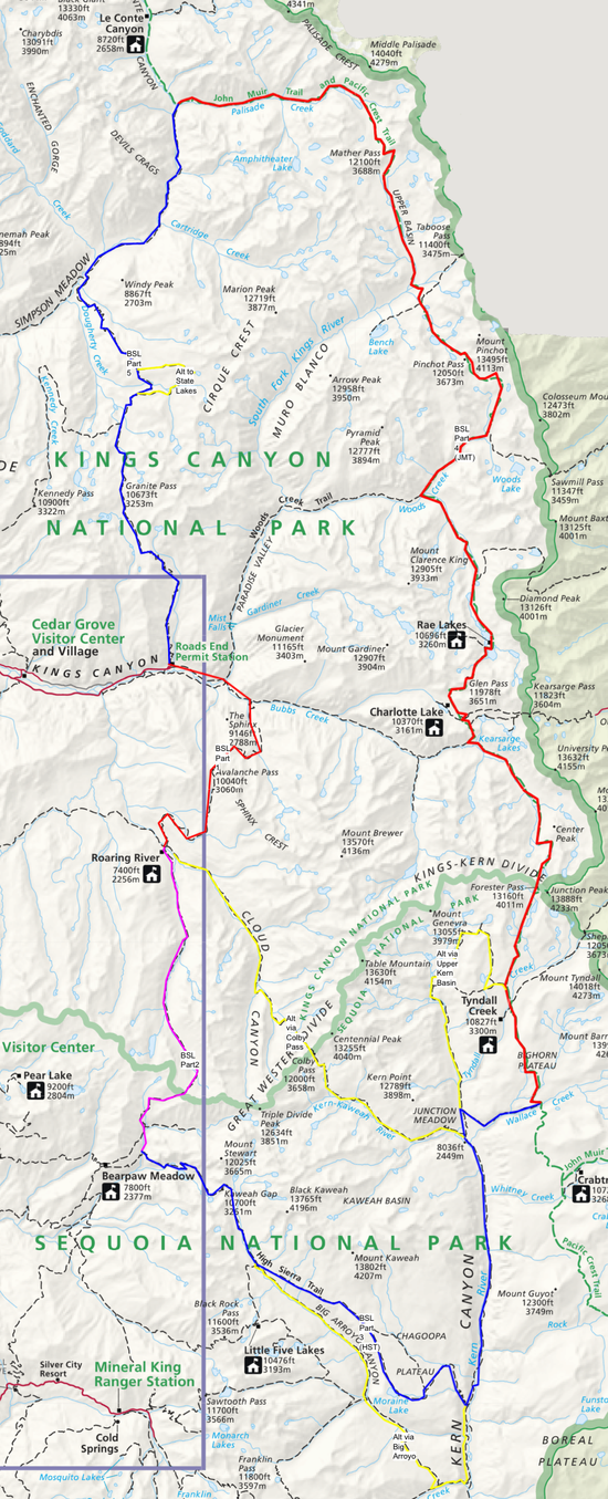
And here's an overview map of the trail (also found in the thread):
https://dpcr19kltm61a.cloudfront.net/backpackinglight/user_uploads/1361290027_76348.png

Thank you so much for your help!

Sam Buchta BPL Member
PostedApr 20, 2015 at 8:26 am

edit: I somehow missed that you're already in California so getting to the east side of the Sierra might be just as much trouble as getting to Road's End. I think you could still take public trans to the east side but it'd be a long day.

Theo, if you haven't already purchased any tickets for travel, you could always start your hike on the east side of the Sierra. I believe you can hire shuttle services from towns like Lone Pine up to trailheads like Onion Valley, etc. If you fly into Reno, there's a bus (Eastern Sierra Transit Authority) you can catch that will take you to Lone Pine or Bishop, etc.

Then it'd be pretty easy to hike in and pick up the trail from there, then exit back out where you came in after you make your loop. I'm not sure if you can schedule a shuttle far in advance to take you out but people seem to have pretty good luck hitchhiking from the Eastern Sierra trailheads. Downside is permits might be tougher to get a hold of, but if you're not trying to hit up Mt. Whitney along the way you probably can get something.

Lori P BPL Member
PostedApr 20, 2015 at 8:36 am

Dorst was one of the campgrounds they shut down last year due to lack of water. I would bet pretty heavily that it will be worse this year and shut down even earlier.

I would sooner post here on the forum to see if a local would be willing to take you up there. Pay gas money plus a little extra and give a guy/gal a reason to get a permit and go for a hike after dropping you off. :P

Public trans is going to get a little easier this year for Kings/Sequoia, but not by much. Doesn't appear that the new line of busses from Fresno will include Roads End.
http://www.tripadvisor.com/ShowTopic-g143050-i904-k7886803-Fresno_to_Sequoia_NP_Shuttle_Bus_Begins_in_Summer_2015-Sequoia_and_Kings_Canyon_National_Par.html

As for day hikes in the parks, they are legion and excellent. I have quickly come to favor SEKI over Yosemite, for the ease of entry into the alpine plus the radically reduced crowds. It's a backpacker/hiker paradise. One of my favorites is Alta Peak – arguably one of the more strenuous day hikes around, frequented by folks who are planning a Whitney attempt, but excellent in its own right.

ETA: If I were going to do this loop, and using public trans, I would reserve a permit for Crescent Meadow which is at the Giant Forest Museum – shuttles stop there. Yes, it is the starting point for the High Sierra Trail and definitely in demand, HOWEVER, if you take the Elizabeth Pass trail instead of continuing up to Hamilton Lake, it takes you through Deadman Canyon (fantastic, remote place with almost no foot traffic) and you can go on a longer variant of the loop, or use Woods Creek, Bubbs to Vidette, or even do a lollipop using the Cloud Canyon/Colby Pass trail, making the return trip back through Deadman. Elizabeth is a HARD pass, tho, for anyone who is not acclimated to long high elevation uphill slogging!! (it's hard for those of us who regularly hike at elevation too) and the trail is nearly not a trail, tho you can find a route to the pass by just getting to the bottom of the switchbacks however you can. BUT, I truly enjoyed the views and the solitude of it.

You could also ride shuttles to Wolverton. If you can get a permit for the Alta trail – usually not hard to do – you can connect to the High Sierra trail via a downhill connector.

Theo Diekmann BPL Member
PostedApr 20, 2015 at 11:01 am

Hi Lori,

That's so funny, the idea of including the High Sierra Trail as solution to my logistical problems came to me last night @2am when I couldn't sleep!

Thanks for your numerous suggestions as to how incorporate this extra part in my itinery! I'll have to look in detail at the different possibilities (mileage, elevation) in order to estimate what's feasible for me. I don't think I want to carry more than 12 days of food and I will probably estimate my daily mileage conservatively b/c of the challenging terrain.

In what sense would you describe Elizabeth pass as hard? Physically, due to the elevation or also navigationally or even technically (scrambling)?

Also, could you elaborate what you mean with the "lollipop" including Cloud Canyon/Colby Pass trail? I wasn't able to reconstruct that option using the (online) trail map I have.

Thank you so much for your help! I'm so excited about this trip :)

Lori P BPL Member
PostedApr 24, 2015 at 7:52 am

The trail has been in decline for years, without maintenance. On both sides but especially the south aspect you have to pay close attention to connect the plain dirt trail sections when you've ascended to the point where there starts to be a lot of rocks as you climb toward the pass. Fortunately you see ahead of you on the steepest last half mile there are switchbacks.

The north side is climbing through boulders, and the trail gets long and tedious. One of my companions got tired of switchbacks and just plodded up from boulder to boulder. We ran across three people who had been climbing the pass from the north the previous evening and got caught in the rainstorm that kept my party from going up to the Tablelands to Big Bird. We were trying to get over in the window between the morning's storm (we saw lightning up high over the granite for a couple hours) and the predictable afternoon thunderstorm. The other hikers were soaked to the bone, having been forced by the heavy rain (we had sprinkles, by comparison, having camped in Ranger Meadow) to badly (quickly) pitch a tarp in a tiny grassy spot in the rocks. They were wringing out clothes. They had even been warned by a ranger to not go up. It sounded like quite the adventure… not recommended to attempt it in horrible weather, or any high pass.

We got to the pass itself by noon, had a quick lunch, and hurried down as clouds were gathering. The next three miles (it feels like more) of downhill loses a LOT of elevation to the creek far below, but when you get to one of the drainages (there's one with a nice pool and a small falls into it, if there's still water flowing) about 10-15 minutes of climbing along it gets you to some flat spaces you could bivy in.

Generally, the risk is the same on most of the high passes, when the weather's like this. Usually in fair weather there is just the afternoon showers that dissipate after an hour or two. Just the steepness and the stair-steps of the trail above the headwall in Deadman to the switchbacks on the trail down from the south side for about a mile make it more challenging. I fell down when descending once despite the trekking poles, because I was looking ahead for the trail instead of minding my footing. It's a lot of uneven stepping. I think someone took stock over it in the near past, as there was identifiable horse apples, but they were definitely old. But the stock gates in Deadman are in disrepair.

After the nice gradual and (by comparison) stroll in the park up Deadman, it was interesting.

I was looking at the map in the big SEKI thread. If you follow the highlighted route north through Deadman, you can see it. To Roaring River and over Avalanche pass to Roads End, Granite Pass (The Bitch – this one is not just steeply up but long, earns its nickname), Simpson Meadow, connecting to the JMT and coming south over Mather, Pinchot and Glen Passes, cut down Bubbs and route the return through Cloud instead of Deadman. If you want a lazier route with fewer passes you could do the wood creek trail instead of coming out to Roads End, wander around the Rae Lakes loop (one pass there instead of four) and then cut back down Bubbs to connect with Avalanche/Clouds, or continue down the JMT over Forester (one of my favorite passes) and hook up with the High Sierra Trail. Kaweah Basin, Precipice Lake, and Hamilton Lake! the fishing at Hamilton is good tho you can't keep the rainbows.

None of this stuff is more than Class 1. There are a few cross country "short cuts" like going over Coppermine instead of Elizabeth, but not for folks who are not so great at routefinding or map work, or those who don't like class 2-3.

Theo Diekmann BPL Member
PostedApr 24, 2015 at 10:44 am

Lori,

Thank you so much for your additional information!
One more question concerning the first alternative you mentioned: You say "… cut down Bubbs and route the return through Cloud instead of Deadman." As far as I can tell from the map in the SEKI thread, the only (non cross-country) way back using Clouds Canyon is by creating some loop using HST or something. Is this correct & what you intended to propose?

In general, it seems like I can either do the full loop, or cut off the top (using Bubbs Creek or Woods Creek) or cut off the bottom by exiting on the east side via, say, Whitney Portal. Which way is more worthwhile? From what I've read so far, the south route, including the High Sierra Trail and parts of the JMT is more easy-going and more populated, whereas the north part is more strenuous and solitary. Is my impression correct?

Lori P BPL Member
PostedApr 24, 2015 at 11:31 am

If you don't want cross country, yes, you'd have to rejoin the HST. There's short cut over Pants Pass to Nine Lakes – but that's probably a bad idea. Most folks who've done it don't go back. :/

If you're on the trails, yes, the southern parts will be more crowded. You could also exit via Kearsarge to Onion Valley. But you might want to have a shuttle to meet you there, or be willing to hitch. Or, extend down the PCT to Horseshoe, avoiding the Whitney crazy crowds.

Theo Diekmann BPL Member
PostedApr 24, 2015 at 11:38 am

Actually, I don't mind other people on the trail too much. I would probably choose the more beautiful route if I feel physically fit enough to tackle both.

Bob Gross BPL Member
PostedApr 24, 2015 at 2:07 pm

"by exiting on the east side via, say, Whitney Portal. Which way is more worthwhile?"

You will not be exiting via Whitney Portal. The permit is rather difficult to get at this late date.

–B.G.–

Theo Diekmann BPL Member
PostedApr 27, 2015 at 1:37 pm

Thanks Bob for the heads up concerning Whitney portal! I can summit Mt. Whitney with just a backcountry permit, though, right? Yes; I did research on that myself, however I am sometimes unsure if I understand the texts (http://www.nps.gov/seki/planyourvisit/whitney.htm) entirely correct – no native speaker. Hence my seeking confirmation.

I have received confirmation for a backcountry permit starting and ending at the High Sierra Trailhead. I am still waiting for the map that I've ordered but so far I think I will start the Big Seki Loop along the High Sierra Trail and then continue counter-clockwise. Like that, I have the solitary parts towards the end. Also, depending on how how physically fit I am and how comfortable I feel, I can attempt the entire loop or shortcut via Bubbs Creek or Woods Creek.
In case I shortcut, I still have the option of summiting Mt. Whitney (if I understood the permit requirements correctly) to stretch the trip a little.
I guess that leaves me plenty of options. Feel free to comment!

Bob Gross BPL Member
PostedApr 27, 2015 at 2:50 pm

My understanding is that you are allowed to camp at Crabtree Meadow, then summit the peak and return to Crabtree. You are not allowed to camp on the summit, although some hikers plan their climb so that they reach the summit for sunrise. If you tried to bail out and exit on the Whitney Trail, then you would be subject to a citation. I've had my Whitney permit checked about 15 times, so I know that the rangers are out there.

–B.G.–

Amy Lauterbach BPL Member
PostedMay 3, 2015 at 10:09 am

Theo – In the main Big SEKI Loop thread, Martha Bryan posted about getting to Roads End from Fresno. It's a long shot, but you could contact her and see if you can make the timing work so that the two of you could share the cost of renting a car. Or, if you're not price sensitive, you could plan to rent a car yourself and post on pre-trip-planning thread asking if anybody else wanting to get to Roads End would share the cost with you.

Otherwise, I'd take the shuttle into the park and hitch to Roads End. In general, it's fairly easy to hitch inside the park (although fairly long distances) but not as easy to hitch from an urban area.

Getting back to Visalia or Fresno from the park might be easier to hitch. I've done so myself by simply asking an exiting backpacker at a trailhead if they were driving to a town and be willing to give me a lift.

I want to reiterate that Jim and I laid out this route considering lots of factors, and it really is best (by a fair bit) to start it at Roads End. The reason is that the least interesting pieces of the route are the 5-8 miles on either side of Roads End, and by making those pieces be the first half day and the final half day you have one very long intact continuous piece of fantastic walking, uninterrupted anything that is less than five-star. There are MANY other options for hiking in the Southern Sierra, and if you can't find a way to Roads End I personally would not choose this particular loop. Obviously other people with lots of hiking experience in the Southern Sierra would have different perspectives.

And finally, I can't think of a better way to finish a year in CA than to hike the BIg SEKI Loop. As far as trail hikes go, it has more bang for the mile than any other long Sierra hike, IMO.

Amy Lauterbach BPL Member
PostedMay 3, 2015 at 11:32 am

In original post, Theo wrote: My idea is to arrive in the Sierra with all my stuff for the BSL plus a small summit pack, stay at some campground for 2-4 nights, do some nice dayhikes and then start the BSL already warmed up and acclimated.

Theo, here's another idea that follows the "climb-high, sleep-low" approach described in the wiki article: http://en.wikipedia.org/wiki/Altitude_sickness

Roads End is at 5000'. On the first day, just hike a few miles, up to Lower or Upper Tent Meadow at 7600-8800 feet. Take it slow and easy. It's all uphill, and your pack is heavy with food, and you're not acclimated. It's a south facing slope at low elevation and it can be sweaty hot. So don't try to get all the way up to Granite Basin at ~10000'.

On the second day, cross Granite Pass and descend to Simpson Meadow (6000'). This gives you part of the day at 10k', but has you sleeping low again.

The third day is then a long slow steady climb from 6K. The junction with the JMT at Palisade Creek is at 8000', still fairly low altitude. If you only go as far as Deer Meadow you could camp again at 8800'. Or if you're feeling OK w.r.t. altitude, then you could continue climbing up to Palisade Lakes at ~10k'

My favorite camping is at 10k-11k, where there are a few scattered trees and the views are marvelous. But if you're having trouble with headaches and other altitude symptoms, you could always camp at the lower areas and that should help with acclimation.

Theo Diekmann BPL Member
PostedMay 3, 2015 at 12:21 pm

Hi Amy,

Thanks for your reply!
Since I was only able to book a campsite for the night before my hike, I will have to follow the approach you mentioned. However, I will start and finish at Crescent Meadow (High Sierra Trail-Trailhead) and most probably go counter-clockwise (following the HST first) and probably short-cut the BSL via Bubbs or Woods creek. I will try to apply the "climb high, sleep low"-idea to the first nights of my hike.

/edit: I just saw your previous post. Hmm, lots of food for thought again. What I like about my current itinery is the fact that I have the more crowded portions in the beginning and also the option to short cut the trail. On the other hand, starting at Roads End would make it easier to do the entire loop (24 miles less compared to my current plan w/o shortcut), food weight/volume being the limiting factor.

Viewing 19 posts - 1 through 19 (of 19 total)
Loading...