Topic

Mammoth to Yosemite Valley via SHR

  • This topic is empty.
Viewing 9 posts - 1 through 9 (of 9 total)
Kiel Senninger BPL Member
PostedMar 7, 2015 at 9:03 pm

I'm planning a trip in late July from Mammoth to the valley on the SHR until the Lyell Fork area, then pick up the trail down to the valley. My current idea is to descend the slope between Foerester Creek and the Lyell Fork down to Triple Peak Fork, ford that and pick up the trail on the west side. That descent looks pretty slabby on Google Earth, just not sure if it's too steep to hike down and not sure what to expect at the river crossing. Anyone ever been down that slope and crossed that fork of the river around there?

Also thinking about taking a day to go up Ritter from the upper Ritter lake if anyone has ever done that and wants to share a horror or success story.

Thanks!

Here's a CalTopo link. Proposed route in red and orange.
http://caltopo.com/map?id=6J0P

edited to fix a lot
Bob Gross BPL Member
PostedMar 7, 2015 at 9:36 pm

From the Lyell Fork (not Lyle Fork), you can descend pretty easily to the High Trail. Once you cross it going west, it'll get a lot tougher getting down to the Triple Peak Fork (not the Triple Divide Fork). I would not call that a river. In summer, it is a medium stream. This summer, due to the drought, it might even be a small stream.

–B.G.–

Kiel Senninger BPL Member
PostedMar 7, 2015 at 9:57 pm

Man, a lot of mistakes in that first post. Thanks for catching that, Bob, and for the info.

Bob Gross BPL Member
PostedMar 7, 2015 at 10:24 pm

Ritter Lakes are on the west side of Mount Ritter. Lake Catherine is on the north side of it. One standard route goes from Lake Catherine up the glacier to the Ritter-Banner Saddle, and then up the John Muir rock route which is on the northeastern side.

–B.G.–

PostedMar 8, 2015 at 10:59 am

Kiel,

I haven't descended that exact section you speak of, but I did drop down from Adair Lake/WL 9705 to the Red Peak Fork which is just west of there and is a lot steeper according to the topo and it was fine. As usual, micro route-finding is key; if you can find a nice continuous granite joint to descend your life will be much easier. Looks like there are plenty of trees that connect the whole way down that slope so I would not personally hesitate to try it.

I have not climbed Ritter, the winds were blowing 40+ mph when I passed Lake Catherine on the SHR. But we had pretty thoroughly researched it and I'd still like to go back some day and climb it from the west. I'd say it's worth giving it a shot as long as you have the proper experience.

Edit: One more thing, you probably won't want to camp at Lake Catherine; it's pretty much all talus. Lots of good camping just west of there above the San Joaquin, though.

Andrew

PostedMar 8, 2015 at 11:02 am

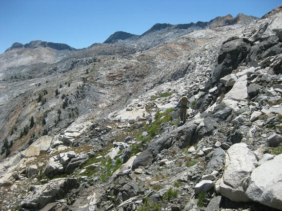
This is the slope on the northwest side of Red Devil Lake…your route should be less steep if you hit it right:

1

Bob Gross BPL Member
PostedMar 8, 2015 at 12:30 pm

Even the trails around there are rough. For example, Red Peak Pass.

One time 25 years ago, everybody was bitching about how overused and overrun everyplace in Yosemite had become. I went out to survey the various lakes, especially of the Clark Range, which saw extremely little use. Out here, once you step off the main trails you are on your own.

–B.G.–

PostedMar 8, 2015 at 1:06 pm

If you want a easier peak bag, Banner is just a long talus hike up from Lake Catherine, and the views are incredible also.

Bob Gross BPL Member
PostedMar 8, 2015 at 1:23 pm

Years ago, a buddy and I had hiked over from Waugh Lake to Lake Catherine. We walked up the glacier to the Ritter-Banner saddle. At that point, my buddy liked the looks of Banner, so he went that way. I liked the looks of Ritter, so I went that way. We agreed to meet back at the saddle after a few hours. I had a pretty interesting adventure going up and down Ritter, and I was returning to the saddle. I slipped on some old snow and sliced up my right palm on a sharp flake of granite. That was awkward. I think that I was dripping blood all the way back to Waugh Lake. We concurred that Ritter was a little more challenging than Banner. Of course, by this summer there might not be any snow at all up there.

Banner has a better view to the east. Ritter has a better view to the west.

–B.G.–

Viewing 9 posts - 1 through 9 (of 9 total)
Loading...