Introduction
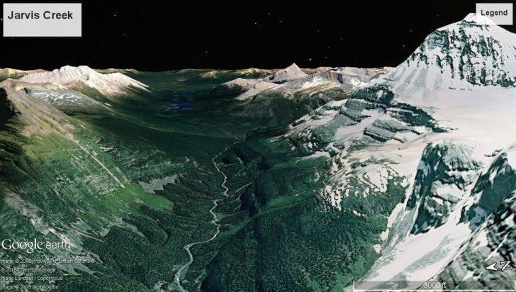
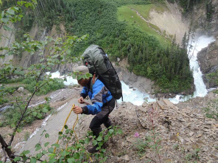
Ben and I used Google Earth to plan a trip on the Wood River and the results were “interesting.” Our five-day trip turned into an eleven-day slog as we fought through horrendous brush, canyons, devils club, waterfalls and unsafe rapids. After that, I put a lot of time into looking at what went wrong and how I could use Google Earth more effectively for future trip planning.
Fortunately, I learned a few tricks that made my next summer of exploring much more fun. This article will cover:
- case studies of specific trips,
- weaknesses of Google Earth,
- how to use Google Earth to plan a packrafting trip,
- and how to use Google Earth to scout routes in the mountains.
I use Google Earth mostly to scout rivers; hence this article will focus on that. I don’t do much planning using Google Earth for hiking trips, although I have definitely wasted a lot of time daydreaming about hiking trips on Google Earth.
Case Study 1 – The Wood River
Planning
Ben and I planned our 2015 Wood River trip over Facebook and neither one of us did in-depth research.
Our planning consisted of looking at Google Earth and putting a few potential waterfalls into Ben’s GPS. Ben told me later he assumed the terrain would be similar to the east side of the Canadian Rockies. Farther east the valleys tend to be broad (similar to the South Fork of the Flathead in Montana), and the trees are not too thick. I didn’t do much of my own research because I assumed Ben had it under control.
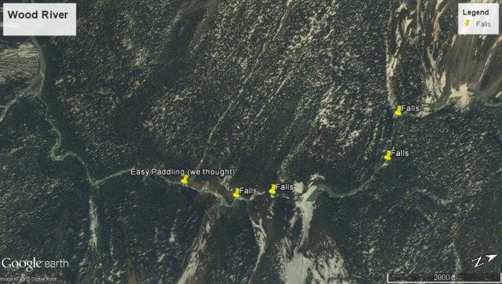
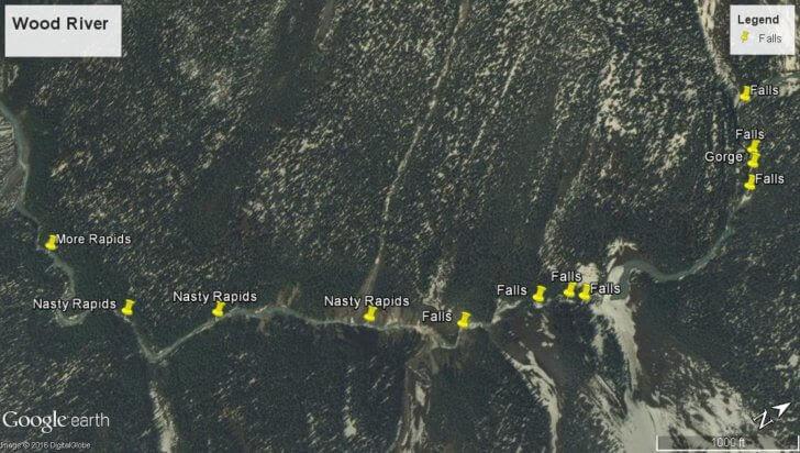
We knew there were a few waterfalls on the Wood River but that wasn’t a big worry. They were marked in Ben’s GPS and the whole stretch of waterfalls and large rapids was only a few miles long. We thought in the absolute worst case scenario we could bushwhack around everything and fully expected the lower part of the Wood River to be runnable.
Trip
Member Exclusive
A Premium or Unlimited Membership* is required to view the rest of this article.
* A Basic Membership is required to view Member Q&A events

Discussion
Become a member to post in the forums.
Companion forum thread to: Case Studies: Using Google Earth to Plan Wilderness Trips
This article presents some case studies of using Google Earth for wilderness trip planning, with a presentation of my process and lessons learned.
On your #2, I’d add for burn scars you may need to talk with someone familiar with plant (successive) growth. In the western Gila wilderness after a massive burn, a major trail has been cleared (plenty of hunting expeditions), and the various maps (at the ranger stations or online) just show trail/”maintained trail”.
However for hikers, fast growing spiny cats-claws make it rough for hikers unless, as the ranger put it, the hiking party wants to bring pruning shears and I’d add, a machete. It will be this way for the next few years until the trees grow enough canopy where the shade kills the spiny plants. So Goggle Earth is great (even the mobile apps both Mac and Android), but talking to knowledgeable people who’ve been on the ground can be essential to having a decent trip.
Thanks Luke.
I just took another look at a river I’ve had on my radar. Looks like 225′ feet per mile for the first 4 miles (2300 to 1400′). Hmm….looks like a problem.
But after the first four miles it drops from 225′ per mile to 60′ per mile (aside from that one steep gorge). That might work:
Good article, many lessons learned the hard way, which often is the only way that works.
Lots of thoughts on this kind of trip planning:
– Use the Google Earth historical imagery timeline to view photos in different lighting, seasons, and years. Knowing roughly which year that burn happened can help you avoid a suffer fest – or plan on it. A snow-covered scene with late afternoon lighting can show you details invisible at noon in mid-summer.
– Most people (including me) are terrible at interpreting “flat” photos for 3D content. That’s one reason Google Earth combines topography with photos to help you see in 3D. Examine critical points from multiple compass angles and azimuth (vertical) angles. I’ve had many “aha” moments just playing around, even in heavily forested areas where the vertical view is almost uniformly dark green.
– However, combining relatively crude topography (common in forested wilderness areas) with highly detailed air photos can produce weird artifacts and misleading impressions. Google Earth also makes it too easy to fly under or through solid earth without warning.
– You absolutely should compare maps, topography, and images from other reliable sources like Bing maps and local authority maps (e.g. National Park or National Forest maps in USA). Some of them might be available only in paper. The horror!
– Even with the best air photos, topo maps, software, and interpretive skills, you’ll still be surprised. That’s kind of the point in striking off trail or floating rivers with no mile-by-mile trip guide. Plan for extra time, supplies, equipment, and skills to get you out of tough situations. Don’t be afraid to say “let’s turn around and live to play another day.”
– River gradient is very important, but not everything. If it’s over 100 feet per mile, probably big trouble. Anything under needs further investigation.
– For example, the Colorado River through Grand Canyon averages about 8 feet per mile. “Hours of flat water punctuated by 20 seconds of terror,” including some of the biggest rapids in the Southwest. Geology, landforms, and climate are equally important in determining the frequency and difficulty of rapids along a river. More beta is better.
– Don’t be fooled by average gradient over long distances. Some rivers are relatively flat for many miles, before they drop into a short steep gorge, then flatten out again, e.g. California’s Trinity River above and below Class V Burnt Ranch Gorge. If you think “only 40 feet per mile average gradient, we’re good to go,” you might be unhappily surprised. Consider calculating mile-by-mile gradients to be sure.
– As the story mentions, a bright stretch of river could be deadly whitewater, gentle riffles, a boneyard of white rocks – or simply the sun reflecting off flat water. Another reason to look for photos at other times and dates to help you sort it out.
– For some rivers, you can match historical air photos with historical flow information from an upstream or downstream gage, to scope out what the river looks like at different flows. That can help you identify hidden rapids, and plan your trip for the best flows – or the flows you’re stuck with for other reasons.
– Remember, dangerous rapids at low flows can disappear at high flows, and vice versa.
– Rivers change, sometimes in a flash (flood). Always expect the unexpected around the next bend. In the Grand Canyon, Crystal Rapid formed virtually overnight in 1966, changed almost continuously for the first couple of years, changed again in the big floods of the 1980s, and is still one of the most challenging rapids in the Canyon 52 years later.
– As described in the story, one side of a mountain range or ridge doesn’t predict what the other side will be like. Differences in geology, climate, sun exposure, trail development, and many other factors can make a big difference in vegetation, soil, and rockiness.
Hard to imagine John Wesley Powell and company heading down the Green and Colorado rivers in wooden boats rowed backwards, knowing almost nothing about what to expect downstream. That was an adventure in the unknown!
— Rex
Also, if a nearby river has well-known gorges, waterfalls, or major rapids along fault lines, or changes in rock type, etc., you might be able to extrapolate to your river of interest. Often you can trace these features on topo maps, terrain maps, or air photos; a geologic map can help if available. Even if you can’t interpret the symbols on a geologic map, lining up rapids with colors and borders, and following those borders might tell you a lot.
Similar logic might help you scope out difficult cliffs and canyons on land, too.
— Rex
Good thoughts Rex. I haven’t looked at geologic maps but I have noticed that parallel rivers often have for gorges that seem similar at similar elevation. I’d guess the underlying rock is similar.
Become a member to post in the forums.