Topic
Teaching land navigation
Forum Posting
A Membership is required to post in the forums. Login or become a member to post in the member forums!
Home › Forums › General Forums › Philosophy & Technique › Teaching land navigation
- This topic has 12 replies, 6 voices, and was last updated 8 years, 9 months ago by
 Bob Moulder.
-
AuthorPosts
-
May 28, 2016 at 6:25 pm #3405305
I’m trying to put together a short presentation on land navigation for an outdoor club. (There’s already plenty of very good resources out there so I tell myself I’m trying to integrate useful bits from all of them.) My main goals would be to cover:
- How to read and understand a topo map.
- How to use a grid system.
- How to use a compass.
The slide deck I put together is located here: https://docs.google.com/presentation/d/1Oo8RdRqMIFN5hVurcLEvlNKQ24TB8mIsJgiqUWv9zxM/pub?start=false&loop=false&delayms=3000
However, I wonder if I have too much detail in there for an hour’s time and may have overcomplicated some parts. Particularly after reading the Geraldine Largay thread, I’m wondering how best to re-work the material. One suggestion I got was to simply talk through a number of example scenarios and hide the concepts within them. I’m wondering what other ideas there might be?
-J
May 28, 2016 at 6:42 pm #3405309Excellent presentation Jeremy, but yes, too much detail for an hour’s time. You’ve got nearly 60 slides, which means barely a minute per slide. And that’s without questions and further explanations.
I’d say go back to your main goals, and put everything that doesn’t specifically relate to those in ‘supplemental’ slides at the end – if you get to them, great. If not, they’re still there for additional information.
I’d try to get it down to no more than 30-35 slides (not including supplemental and appendices) to give ample time for discussion and questions/answers within an hour time frame.
May 28, 2016 at 9:37 pm #3405338Great job! Didn’t know anything about PLSS township stuff.
I think you’re right, example scenarios are best… and really the easiest to learn from.
Maybe you can wrap it up in a “Geraldine Largay” kind of fictional scenario, and walk people through what to do when they realize they may need to yank out the map and compass.
The NAD27 vs. WGS-84 stuff is good to cover, first GPS I got as a teenager (didn’t have any kind of topo screen), I headed into the woods to take a reading and compare it to a map and felt like a total boob when it didn’t make sense.
Or learning about declination because I found Polaris one night, but was totally confused because my compass needle was pointing 14 degrees to the right of it.
I wonder if there isn’t a way to hang a few mountain peak pictures up to help simulate triangulation, and if people wanted to after the demo, they could give it a shot with a photocopies of a map with those peaks on it.
May 29, 2016 at 6:44 am #3405399Great presentation, Jeremy, but waaayyy too much info for the average person to realistically absorb in one hour. It should be vastly simplified.
Just MVHO and cutting to the chase:
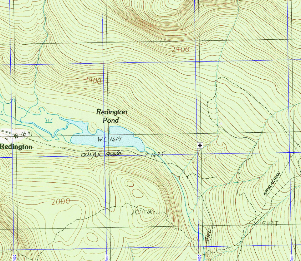
For topo maps, just the basic features and a discussion of what it means when the lines are close together and far apart, the V for direction of drainages, what a steep hill looks like and a gentle hill, and a cliff, the distance scale, pointing out a steep trail and a flat trail, lakes and swamps, and how to use the legend.
Regards to lat/lon, keep it super simple with the illustration and focus on the different formats (dd.dddd, dd.mm.mmm dd.mm.ss, etc) In my experience the most confusion comes from the format, and suggest that they settle upon dd.dddd and remain alert for different formats.
For grid system discussion, forget all the other stuff and stick with UTM, with the only discussion of NAD27 and WGS84 being to make sure the GPS matches the map legend if using GPS coordinates to locate yourself on a map.
For compass, magnetic north, true north and declination. Definitely don’t get into Grid north, Mercator Projection and all that. Too esoteric at this point.
Even vastly simplified, you will be flooded with questions and the hour will absolutely fly by.
At the end of the hour, suggest reading materials such as Bjorn Kjellstrom’s “Be Expert with Map and Compass” and say “Let’s look forward to some day-long sessions outdoor!”
May 29, 2016 at 8:40 am #3405413I agree with Bob et al that it is a great job but too long and detailed for a first time group. You could break it into two presentations for folks who want to know more after some field practice. After slide 43 you could drop all of that other than the references. Like Bob suggested you could simplify some things like all the various datum stuff.
Thanks for the lesson!
May 29, 2016 at 11:20 am #3405434This looks great. I’m in the beginning stages of learning land navigation so I can appreciate the in depth presentation but would like to go through it on my own time.
Any chance I could get access to it and save it before you modify it?
mattMay 29, 2016 at 3:54 pm #3405483Thanks for all the feedback! I think I’ll do a much shorter version, but will preserve/add to the current one as well.
Doug: It’s now actually close that 35 when the headings, etc. aren’t counted, but I agree, it’s still a lot.
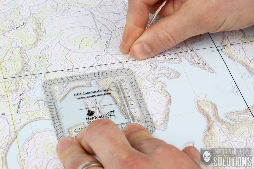
Brandon: I’m looking for a very simple map to print out and use for hands-on practice. Using compasses in a room would be difficult, but printing out a bunch of small protractors might work. (hole punch in the center to see the origin, angles printed around the edge, and a short bit of thread to read the angle similar to this.)
Bob/Alex: Yep; I plan to skip the appendices; that’s just for further reading. For coordinates I’m thinking of a message like “Use UTM. If you must use lat/lon because that’s what’s in your guidebook, make very sure the punctuation matches your GPS device.”
I’m tempted to pull most of the compass info, actually, and reduce it to a bare minimum, e.g. “The dial rotates. Use it as follows: Compass and map? The N’s on each need to point the same direction. Compass and landmark? The N on the dial needs to match the needle.” A separate ‘in the field’ practice could then cover more detailed compass use.
Matt: A pdf copy is available at https://www.amazon.com/clouddrive/share/ot6ZMJ0VvqZs1TXwpeJ0LHxQuptytQE3YMkOeuYt9y0?ref_=cd_ph_share_link_copy (the font didn’t transfer well to Powerpoint).
May 30, 2016 at 11:37 pm #3405944Ok, I’ve placed a more basic version at: https://docs.google.com/presentation/d/1S7iMXCGiF2KEIZhsSWNopB_DEUWuWhExcDWxrVW4Whw/pub?start=false&loop=false&delayms=5000
It’s almost too basic, but I hope should cover just enough to both be remembered afterward, and be enough to get someone out of trouble.
May 31, 2016 at 4:56 am #3405956That looks great — I really like your idea of the “Gotchas”, very clever!
This and the longer version deserve “Sticky” status. ;^)
May 31, 2016 at 3:34 pm #3406132Forgive me, as I’m somewhat “un-coordinated” (and forgive the pun).
Slide 21, you talk about seeing if there is a newer version of maps if they have NAD27. So, I went through my maps that are at least 2008 or newer (only like 10 or so). There was only one that wasn’t using NAD27. The wildcard was a very recently created Nat Geo of a Big Basin State Park. Should I really expect many maps to be using a newer datum?
May 31, 2016 at 4:14 pm #3406142Thanks Bob!
Brandon, you’re correct, many maps are still on NAD27, so my comment there may be a bit presumptuous. People with collections of classic USGS topos likely have a large number of such maps, and I suspect artisanal mapmakers like Tom Harrison have stuck with it also.
I think it’d only be an issue if you were trying to use a guidebook and a map together, in which case you’d probably have a bigger problem.
The current USGS topos should all be on WGS84; one of their FAQs says “This issue is of declining importance. It is seldom relevant to anything other than historic maps, roughly maps published before 1990. All modern maps and GIS data are cast on NAD83 or WGS84, which are equivalent datums at map scales of 1:5,000 and smaller.”
-J
May 31, 2016 at 5:43 pm #3406168It somewhat surprised me that almost all my National Geographic maps, even the ones revised as recently as 2012 are still using NAD27.
May 31, 2016 at 6:09 pm #3406175The difference is substantial… black grid is NAD27, blue is WGS84. Also highlights the error in assuming Grid North is true (and, correspondingly, East-west for that matter!)

-
AuthorPosts
- You must be logged in to reply to this topic.
Forum Posting
A Membership is required to post in the forums. Login or become a member to post in the member forums!
Trail Days Online! 2025 is this week:

Thursday, February 27 through Saturday, March 1 - Registration is Free.
Our Community Posts are Moderated
Backpacking Light community posts are moderated and here to foster helpful and positive discussions about lightweight backpacking. Please be mindful of our values and boundaries and review our Community Guidelines prior to posting.
Get the Newsletter
Gear Research & Discovery Tools
- Browse our curated Gear Shop
- See the latest Gear Deals and Sales
- Our Recommendations
- Search for Gear on Sale with the Gear Finder
- Used Gear Swap
- Member Gear Reviews and BPL Gear Review Articles
- Browse by Gear Type or Brand.
