Topic
PNW / Seattle – Weather alternates ? Sept 29 – Oct 5, Burger/Beers?
Forum Posting
A Membership is required to post in the forums. Login or become a member to post in the member forums!
Home › Forums › Campfire › Trip Planning › PNW / Seattle – Weather alternates ? Sept 29 – Oct 5, Burger/Beers?
- This topic has 16 replies, 5 voices, and was last updated 7 years, 4 months ago by
 Jerry Adams.
-
AuthorPosts
-
Sep 28, 2017 at 3:08 pm #3493701
<span style=”font-weight: 400;”>Flying into Seattle tomorrow night (Friday 9/29).</span>
<span style=”font-weight: 400;”>Planning on backpacking the Spider Meadow/Buck Pass loop Saturday – Tuesday (3 nights, 4 days) (9/30 – 10/3).</span>
<span style=”font-weight: 400;”>Weather is turning crummy (to be expected this time of year).</span>
<span style=”font-weight: 400;”>Does anyone have suggestions for some alternate spots that might have better weather, this specific week?</span>
<span style=”font-weight: 400;”>Any tips on where to eat and get a beer, in or around Leavenworth? 59diner? Any good?</span>
<span style=”font-weight: 400;”>Thanks!</span>
Sep 28, 2017 at 3:12 pm #3493703Sweet formatting! huh. Sorry about that. Here it is again, only this time, it is actually readable.
Flying into Seattle tomorrow night (Friday 9/29).
Planning on backpacking the SPider Meadow/Buck Pass loop Saturday – Tuesday. (3 nights, 4 days) (9/30 – 10/3).
Weather is turning crummy (to be expected this time of year).
Does anyone have suggestions for some alternate spots that might have better weather, this specific week?
If we stick to our plan, any tips on where to eat and get a beer, in or around Leavenworth? 59diner? Any good?
Thanks!
Sep 28, 2017 at 3:29 pm #3493706You can use the NOAA point forecast for different locations in WA state to see if there’s any dryer forecast area, but it looks like a widespread system moving in later this week:
http://forecast.weather.gov/MapClick.php?lon=-120.91481&lat=48.15830#.Wc0SZVtSzmE
The Eastern Pasayten Wilderness has a little dryer forecast than the rest of western WA, but there may still be fire closures in that area.
If you’ll be hiking in WA mountains this weekend, best expect to get wet, cool weather and snow, regardless of your destination. If in doubt, you can always car camp and do day hikes instead. If it’s wet I like to stick to established trails that are brushed if possible. There is a lot of brush on many trails in WA that gets you soaked head to foot, depending on the height and how many years it’s been since the trail was brushed out. Trails like the PCT and other popular trails are usually the exception – if you have good rain gear and especially an umbrella you can stay mostly dry except for your feet and lower legs maybe.
Big, deep woods, like some of the long valleys in the Olympics, can be pleasant in rain as the view is not hindered by rain and deep woods often have less brush.
Sep 28, 2017 at 3:52 pm #3493709” long valleys in the Olympics”
Enchanted Valley has bears, but maybe that’s more in the spring
Dosewallips is on the East side, a little drier
Dungeness Spit is in the rain shadow, so drier, but not a backpack. I’ve camped at that county campground
There must be places East of Cascades at lower elevation that would be drier. Like around Wenatchee or Chelan or along the Columbia River
Sep 28, 2017 at 3:54 pm #3493710I just glanced at beach of Olympics, like Toleak Point or Sand Point. It’s rainy but not a lot – see Lester’s link
Sep 28, 2017 at 4:48 pm #3493718Avoid 59er Diner… plenty of good places within Leavenworth proper.
Sep 28, 2017 at 9:36 pm #3493762“Avoid 59er Diner… plenty of good places within Leavenworth proper.”
Starting with Gustav’s. A trad hangout with climbers and hikers, among others. Also used to be popular with the locals. I haven’t been there in a few years, but certainly worth checking out.
+1 on The Pasayten being worth checking out; Also, there are good routes on Icicle Ridge.
Sep 28, 2017 at 9:50 pm #3493767Crap guys! Sorry for checking out of the conversation. I thought all day that I would get an email if someone posted. Maybe its better though. Got to finish up a bunch of work.
Thanks very much for your input.
Lester, I’m happy to hear someone local confirm what I was seeing as far as how widespread the system will be. Freshened up the DWR last week in anticipation, and packing the heavier overnight insulation.
Jerry the beaches were on my mind, too!
I did have a gander at Old Snowy today, and it looked a bit milder (especially clearer) than the Glacier Peak area.
If you had to chose between the two, for someone who’s never hiked in the PNW … Goat Rocks, or Buck Pass?
https://www.mountain-forecast.com/peaks/Old-Snowy/forecasts/1500
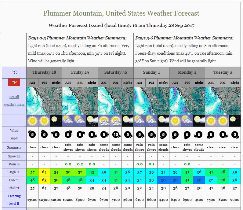
https://www.mountain-forecast.com/peaks/Plummer-Mountain/forecasts/1500
 Sep 28, 2017 at 11:29 pm #3493784
I don’t know about Buck Pass but I’ve probably done 10 trips to Goat Rocks.
I think I’d go up to Goat Lake, camp between there and Snow Grass Flat. Hike up to Old Snowy. Over to Cispus Pass. Enough to keep me busy for a couple nights. Nice camp sites in Cispus Basin. Snowgrass Flat area is too crowded.
Sep 29, 2017 at 12:29 am #3493801Some of those Goat Rocks trails get lots of use and upkeep, especially the PCT, so not much overgrowth of vegetation to soak you while hiking. You’ll likely be hiking or camping in some level of snow, however. Have not done the Buck Pass/Spider Gap loop, but you can check the last several trail condition reports at the Washington Trails Association website, for Stevens Pass-East area in the Central Cascades here:
One nice advantage to camping out on the Olympic Coast is no snow (at least not this time of year) and warmer weather than the mountains. You do need to plan your trip around the tides though, so you hike around headlands to coincide with low tide (some have steep trails up and over too). You are required to get a backcountry permit and use a bear canister on the coast too – the racoons there are agile food bandits.
Sep 29, 2017 at 12:52 am #3493804According to weather report little snow will fall this weekend at Goat Rocks, maybe an inch.
There was a foot of snow a week ago but reports I’ve heard is that’s pretty much melted.
In the winter you can get permit for Olympic coast self issue at trailhead. Maybe call to make sure. If needed you can get it at Port Angeles or Lake Quinalt ranger stations.
Sep 29, 2017 at 5:14 am #3493870You guys are Great Great Great! Def will check out Gustav’s if we head up that way.
I’m trying to hold out on those beach trips for when I can bring my kiddos along. I know they would LOVE getting out there and exploring. Unfortunately, (or fortunately) this trip is just the wife and I.
Lester, I’ve been ALL over the trip report pages at NWHikers, WTA and here. Such amazing resources for a guy sitting in Cleveland trying to plan out a trip! It seems like brush won’t be a huge issue at either goat rocks, or glacier peak wilderness. I think it is mostly going to come down to cloudiness. Precip is a bother, but I can make adjustments to tolerate it. If i can’t see anything in these spots, that would be a major bummer.
Jerry, BIG thanks on the tips for Goat Rocks. I haven’t had as much time to research Goat Rocks yet so this will save me some time! I”m willing to soak anything up you care to offer. Any traction, or axes required up there you think? I’ll get out and read the recent trip reports too, but a few inches of snow I think we’d be OK. If a BUNCH of snow landed, we would opt to stay off the knife edges, etc.
Thanks again guys. Your inputs are MUCH appreciated!
Sep 29, 2017 at 1:24 pm #3493900oregonhikers.org is another site with info, although it’s more portland centric
click on “field guide” and you can get to a lot of details about the Goat Rocks, and the Olympics (mostly those are me – trips I’ve done that I bothered documenting)
you don’t need any traction devices in the Goat Rocks now. The foot of snow from a couple weeks ago has melted off, and this storm is supposed to only have an inch or so which should be easy to walk through.
But it’s always possible this storm could be worse than predicted so be prepared to turn around if conditions look bad. and check weather report at the last opportunity
Sep 30, 2017 at 12:05 am #3494005What kind of car should I rent to get to those goat rocks trail heads?
Most obvious one is snow grass flats or walput lake.
I was thinking I needed and suv to get into the glacier peak trailheads, but if I could rent an economy that would be sweet!!
Sep 30, 2017 at 1:09 am #3494013regular two wheel drive
some gravel with potholes but not too bad, drive slow
I drove my Toyota Camry which is a little worse than average
Sep 30, 2017 at 7:15 am #3494047Jerry, your the greatest! Are you in the Seattle area? I feel like I owe you a cold one!
Sep 30, 2017 at 1:27 pm #3494056Portland
I have a lot of family in Seattle area and do a lot of trips in Washington
Oregon, Washington, B.C., and northern California is a great area, lots of choices for trips
-
AuthorPosts

- You must be logged in to reply to this topic.
Forum Posting
A Membership is required to post in the forums. Login or become a member to post in the member forums!
HAPPENING RIGHT NOW (February 11-21, 2025) - Shop Hyperlite Mountain Gear's Biggest Sale of the Year:

Our Community Posts are Moderated
Backpacking Light community posts are moderated and here to foster helpful and positive discussions about lightweight backpacking. Please be mindful of our values and boundaries and review our Community Guidelines prior to posting.
Get the Newsletter
Gear Research & Discovery Tools
- Browse our curated Gear Shop
- See the latest Gear Deals and Sales
- Our Recommendations
- Search for Gear on Sale with the Gear Finder
- Used Gear Swap
- Member Gear Reviews and BPL Gear Review Articles
- Browse by Gear Type or Brand.
