Topic
Grand Canyon Altitude Sickness Question
Forum Posting
A Membership is required to post in the forums. Login or become a member to post in the member forums!
Home › Forums › General Forums › Philosophy & Technique › Grand Canyon Altitude Sickness Question
- This topic has 23 replies, 11 voices, and was last updated 10 months, 2 weeks ago by
 Diane “Piper” Soini.
-
AuthorPosts
-
Apr 8, 2024 at 6:40 am #3808199
My son and I will be hiking the Grand Canyon, rim-to-rim, in a few weeks. Due to logistical issues beyond our control preventing ability to drive out the North Rim, the GCB NPS has given us opportunity to stay two nights at the Cottonwood campground. To do rim-to-rim, this means our second day will consist of hiking to the top of the North Rim and back down to the Cottonwood campground.
We typically hike around the Appalachian mountain chain, so not used to considering altitude sickness. Not too worried about the hike up, but up and then back down in the same day has me wondering. Is altitude sickness a concern? I’ve looked online and most have lengthened times for ascent and eventual descent, not an up and down in same day. Some of these mention going slow, drink lots of water, and even mention supplements.
Any experience on this? Is it sufficient to hike at a specific pace and ensure lots of water? Not sure about the whole supplement thing.
Apr 8, 2024 at 7:33 am #3808208elevation of rims is about 8,000 feet – not really enough for altitude sickness. And going up, then immediately down is less likely to have altitude sickness.
I’ve hiked from the rim to the bottom and back up. That was a long hike. The bottom is like 2,000 feet – a lot of elevation gain in one day. Yeah, lots of water – 2 quarts? You could have an electrolyte solution, or bring salty snacks.
Apr 8, 2024 at 8:28 am #3808211Wonderful, thank you so much! One of the NPS documents I was looking at made a point to mention altitude sickness, though not a lot about prevention, just that they don’t recommend trying to do down and up in one day and to take it seriously. Mine will be in reverse so really got me to thinkin’.
Out of curiosity, how long did it take for you? I’m estimating ascent to be about an hour a mile and figure that to be conservative. Should be about 14 miles from Cottonwood campground to North Rim and back.
Apr 8, 2024 at 8:52 am #3808213I forget. It was in 1977. I went on a geology field trip so there were a lot of people that weren’t real fit hikers. Down then up. Everybody made it. A couple people were really dragging.
You have to do your own calculation anyway. Count 1000 feet as 1 mile. How many miles is it and how many miles per hour do you do? If its hot you have to factor that in.
Apr 8, 2024 at 8:55 am #3808214I’ve only seen altitude sickness at around 10,000’. We immediately went downhill to around 7,000’. We set up a tent, started a stove for heat. I had some saltine crackers. They settle the stomach plus the salt. I’ve never had it, it depends on the person. Water will increase oxygen levels. Drink plenty. Mostly the lack of oxygen will tire you out. Perhaps a headache. If you can, spend a few days in Flagstaff to acclimate.
Apr 8, 2024 at 10:17 am #3808220Wow… can’t beat personal experience! Thanks for sharing that both real world and causal perspective to be aware of. That will be very helpful as we plan and during the hike. Saltine crackers is a great idea to have on hand too for upset stomach and electrolytes. Never thought of oxygen levels with water intake and wondered why the extra water for altitude.
Due to schedule will not be able to spend a few days in Flagstaff but will be there a day early so can do that much anyways. Haven’t gotten a hotel yet.
Apr 8, 2024 at 10:33 am #3808223When I go above 10,000 feet I get a severe headache. If I go back down a bit it subsides.
To acclimatize, the standard procedure is to walk up a few thousand feet and then back down to sleep for the night. Next day go higher then back down and sleep at a higher elevation the next night, etc.
Apr 8, 2024 at 12:37 pm #3808224Jason, isn’t this a R2R2R, not just a R2R?
I just got back from GCNP a week ago. I’ve tried to go at least once year for the last 45 years, and have probably been 40 times. I usually just hike to the River and back from the South Rim, but also did NR-River-NR one night (Half Dome, Angel’s Landing and NR-River-NR in a frantic 3-day weekend), a R2R2R when I was 1/3 my age and most of a R2R2R on a BPL-associated trip in 2012(?) – other people ran the whole thing, but I don’t run.
I would fret a lot less about altitude sickness at GCNP than 1) hyperthermia* and 2) altitude acclimatization. In round numbers, the SR is 7,000 feet, the NR 8,000 and the river is 2,500. Altitude sickness has been reported at 7,000 in the literature but only among susceptible individuals coming from sea level, with no acclimatization, and going hard at it on days 1 and 2. It’s more likely at the of highest ski resorts, again among flatlanders, who ski long and hard on the highest runs and don’t stop the first day when they’re feeling bad nor the second day when they’re feeling worse. The classic places for AMS in my mind are the iconic walk-ups like Whitney (14,496′) or Shasta (14,179), again, if coming from sea level, and if spending a night at altitude.
* oh, “in a few weeks”, so in late April? I’ve seen 80F at Havasupai / Indian Gardens on May 1 and it was still getting hotter that day. But that’s not the 110F in the Inner Canyon that the summer can bring.
My understanding of your trip is:
Day 1: hike the SK from the SR to Cottonwood Camp dropping 7 miles and 4,780 feet to Bright Angel Campground and then climbing 7.2 miles and 1600 feet to Cottonwood;
Day 2: Hike the NK from Cottonwood up 6.8 miles and 4,160 feet to the NR and then 6.8 miles and 4,160 feet back down to Cottonwood; and
Day 3: the reverse of Day 1.
Three 14-mile days, with very few hiking hours spent at 6,000-8,000 feet. Most of your miles, most of your hours, and both your nights are below 4,000-5,000 feet. Given the vertical climbs and descents, each of those days will tire you out as much as 22-25 flattish miles in a day. For a 3-day trip, it’s as evenly spaced out as is possible.
So AMS would not be a worry of mine, even though I live at sea level. But the lower energy, huffing & puffing, and the feeling of being winded when hiking your usual pace uphill isn’t fun. You can minimize that by getting yourself to high (or still somewhat helpful – an intermediate) elevation for some days in advance. When I was doing Whitney once/twice a year (pre-permit system), I felt noticeably less horrible at 13,000 feet if I’d spent a night at the 8,400′ trailhead than if I just drove from SF and started hiking. The easiest time I had on Whitney was after coming off a 9-day Sierra backpacking trip at 7,000-10,000 feet.
So, for GCNP, I try to add 1-2 nights on the SR (in Tusayan, I usually stay at the Red Feather Lodge; or I’ll treat myself to a Xanterra lodge right on the SR, usually the Maswik Lodge as the more affordable option). Then I’ll spend that first day or two walking the flat rim trail, popping a few miles down whatever trail BA, or SK or one of the lesser-used trails I’m not taking on my big hike day, and let my body adjust a bit to 7,000 feet. I’m usually not into that sort of thing, but actually recommend the iMax movie about GCNP in Tusayan. And, if I get tired to all the tourists oohing and aahing along the rim trail, I’ll just strike off south in the juniper forest – it’s all pretty flat and easy to hike off trail, and if you just head north again, you’ll hit the roads and rim trail easily.
As Terran points out, Flagstaff (7100′) is another place to hang out in advance and get a little acclimatized.
“Lots of water”? Enough so you keep peeing. Not more a lot more than that – you can piss away your electrolytes. I find water applied to head, neck and shoulders more relaxing than sweating to achieve the same cooling. So I’ll dip my bandana or a micro-fiber clothe into streams as I head uphill, drape it on my neck and flip it over every 2 minutes to bring the coolest side against my skin. Less water to treat, carry, drink, sweat, and piss out your electrolytes. If I time it perfectly, a old men’s 100% cotton dress shirt (that I was about to toss) holds lots of water, keeps the sun off your arms and neck, and works for me. BUT you have to quit wetting it out BEFORE the sun goes down and the temps drop or it’ll be cold and clammy when you no longer want that.
The ultimate UL gear on that trip is several $20 bills. Each one is only 1 gram, but at Phantom Ranch can be converted into 2 large lemonades, two granola bars and a Snickers bar. (Or 3 beers, but maybe not on your hike-out day!).
Driving or flying? (sometimes, when I’m squeezing in a GCNP trip from Alaska in 2.5 days, my only acclimatization comes from being in business class at 33,000 feet with a cabin pressure equivalent to 7,500′). If driving, consider routing through Denver or better yet Vail (8,200′), etc on your trip to GCNP.
My other big training thought is that trail miles that include ups and down are great. You’re more sore at the end of the day from the down than the up, so do NOT rely only on a stair climber or treadmill at the gym. You only go up on those. I’ll use the stairs in my house or multiple flights of stairs in a hotel when traveling so I’m going up AND DOWN. 10 minutes every morning before my shower for a few weeks prior really helps.
Apr 8, 2024 at 12:51 pm #3808225Last week the General Store on the South Rim had 110- and 250-gram butane canisters at reasonable prices, but I always feel better grabbing some in PHX at Walmart or REI, just in case. Check if Cottonwood has food lockers (I assume so). For off-corridor camping, I recommend used Danish cookie tins or flavored popcorn tubs ($1 at Salvation Army) for protecting food from rodents / ravens /ants in the campsites. Make sure your toes don’t touch the front of your shoes at all when on a long, long downhill. Older knees can benefit from trekking poles taking 20 pounds of weight off them – normally I don’t use them, but have started doing so in the GCNP in the last decade.
Apr 8, 2024 at 2:23 pm #3808229Jerry’s report of climbing 6,000 feet and then back down in a day is concerning to me, anyway–especially in the GC, where temps can soar. But David’s synopsis suggests that the OP’s itinerary is more relaxed than that.
edit: although climbing from Yosemite valley to the top of half dome is similar to this, and lots of folks do this. But without carrying an overnight backpack. I assume this is the case with the op?
“To do rim-to-rim, this means our second day will consist of hiking to the top of the North Rim and back down to the Cottonwood campground.” in one day.
Apr 8, 2024 at 3:49 pm #3808233lol… fantasic information. You can’t hear it, but that’s the sound of my pencil on paper taking copious notes. You are correct R2R2R for sure. Hwy 67 is closed until May 15, as I understand it. NPS contacted us and basically said we’d have to hike another 45 miles out if we wanted to continue. I replied that we’d try again next year and an out-of-box thinker reached out to me and said there was another day we could permit in Cottonwood the day before if we were willing to modify our flights. After talking it through with my son, we figured why not. Instead of a couple days, now we get three!
I adjusted flights to get us there a day ahead, I don’t trust the airlines as much as I used to. So some great options for stay when we get in and I’ll definitely be checking these out. That was exactly one of my other concerns was staying somewhere close to elevation before we started and some blogs seemed to indicate staying in Phoenix. Seemed awful far away to stay before a big hike.
Good comments on water and food. I have a small micro cloth, just big enough for basic wiping. May get a second from wally-world if they have them for back of neck now. Really good idea.
I actually live on a on a mountain in Tennessee. We’re barely over 2000 ft of total elevation from base, 1050 ft above sea level. My property is on a ridge with about 100ft of elevation at the bottom and back up, so my son and I have been walking it several times, one or two times a week, increasing reps each time plus the basic indoor bike, treadmill, or periodic day hikes on trails close by. Haven’t had a decent trip like this since before COVID unfortunately and a change in jobs at work didn’t leave much room either. Funny thing was how he kept telling me he’s got it. After the first time, he came to me later that day and said “Dad… I didn’t realize how tough that would be”. Lol, he gets it now and doesn’t argue.
Knees are getting older for sure. Son is just 22 and can run laps around me now adays so for the first time I did go ahead and invest in some trekking poles. Gonna have to practice on a trail nearby soon though as I’ve never used them. I’m not sure what my dry weight will come to, but for a typical weekend trip, I would run close to 15lbs, or thereabouts. Packing a lot more for this one for sure hoping to be more prepared than usual. We’ll see soon, hoping to practice pack and weigh everything out this week to make sure I’m not missing anything.
Good call about the butane. I wasn’t sure if I needed to do that in Phoenix or if there was a Walmart or REI closer by. Will definitely make it a priority in Phoenix.
Apr 8, 2024 at 4:18 pm #3808235Please listen to Dave about water, and about electrolytes. Forget altitude sickness.
And the good news is that you don’t have to hike all the way to the NR if you don’t want to–just turn around if you start feeling it. Let your body be your guide.
Apr 8, 2024 at 4:27 pm #3808236Spending the night in PHX is wrong, unless some crazy arrival time dictates it. PHX is at 1135 feet. Tusayan is at 6,600′. And you’ll have the 3.5-hour drive behind you.
Living at even 1000′ or 2000′ is slightly but distinctly better than at sea level. Your red blood cells, respiration rate, tidal volume, and pH are each slightly closer to high-elevation residents so you’re incrementally more acclimatized already.
For butane, there’s a Walmart 40 minutes north of the PHX airport just off of and east of I-17 so right along the route. There’s also a Walmart (and a Trader’s Joe) in Flagstaff, but that’s more of a detour from the shortest route. I usually stop at a Trader Joe’s north of the airport in Phoenix to buy some prepared salads (bring a real metal fork for eating in the car and on the rim) and a wrap for the first lunch on the trail (you only carry it a few miles and they’re all downhill).
On the drive up I-17, I like to stop at Montezuma’s Castle NM to stretch my legs and look up at the cliff dwellings or at Montezuma’s Well NM with smaller but better preserved “cliff” (really crater) dwellings and some weird hydrogeology that’s only recently been figured out.
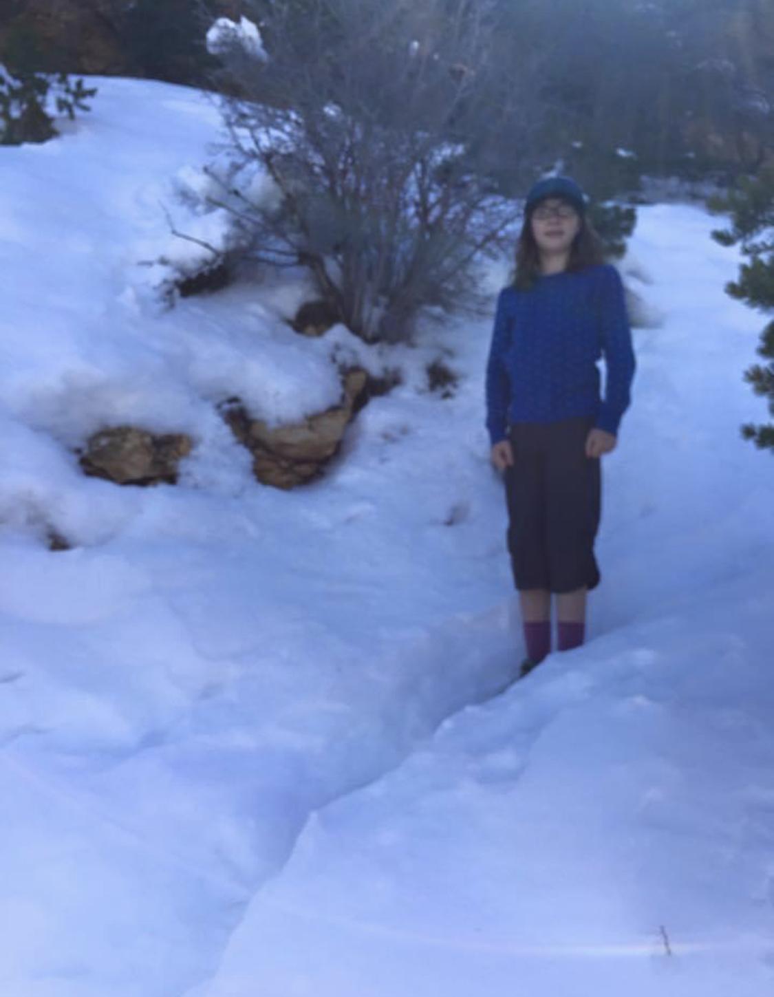
There are all manner of signs, brochure and other warnings that you will die if you attempt to go to the river and back. Here’s my 9-y-o (Alaskan) daughter (in Capri pants) on a less-used SR trail the day before our hike to the river and back one January:
 And here she is at the Colorado:The park service of course has a sampling bias about stupid hikers. The Havasupai Gardens ranger station alone has 600 rescues a year (mostly an unplanned nights rest, food and water so they can complete their “day hike” under the own power, if not on their original plan).
As we got near 1.5-mile-hut on the way up the BA, I mentioned, as a compliment, that she was only 15 minutes off the pace her brother, 12-y-o at the time, had managed, so she ran the last 2 miles up the trail. I did not. It was 9:05 round trip.
Due to construction of a new cross-canyon water pipeline, the Bright Angel trail is closed until April 14th so should be re-opened for your hike. That’s fabulous because: 1) there’s not parking at the SK trailhead unless you get there really early and park along the few parts of the road where it’s allowed, the shuttle buses were really crowded, and the SK got lots more traffic because everyone who’d have taken the BA was on the SK instead and those shuttle busses don’t run as early or late as you might like. Parking near the BA trailhead allows you to start as early as you want (which should be before sunrise IMNSHO) and allows to exit at any time without being stranded after shuttle buses stop and needing to hike another 2.5 miles along the rim back to the visitor center parking lot.
Apr 8, 2024 at 4:40 pm #3808237As Paul mentions, your Day 2 of Cottonwood (4,080′) -NR (8,240′)-Cottonwood (4,080) is the obviously place to adjust the trip if needed. If you’re feeling wiped after Day 1, consider Day 2 being a putter-around, heading a bit more north, but kind of a nero day to rest up for Day 3. And while, sure, you plan to do the hike together, safety wise, either of you solo will see other hikers every 15-20 minutes should a problem arise. Virtually all of my hikes along the trail corridor have been solo from my teens into my 60s. Therefore, if one is feeling it and the other isn’t, you can split up on Day 2 to each do more/less. “From each according to his pack weight, to each according to his knees.” -Karl Marx
Apr 8, 2024 at 5:21 pm #3808238up and then down 4,000 feet in a day is different than up and then down 6,000 feet in a day. I haven’t hiked the GC. I’m a bit confused as to which it is.
And again, if you go from Cottonwood to the NR and back in a day, you’ll only carry day packs? Sorry for my confusion. This last sounds entirely reasonable and easily doable. And yes, I would think altitude sickness would be the least of your concerns. I’d worry far more about blisters.
Apr 8, 2024 at 6:19 pm #3808242Hey, yeah the NPS told me we could leave our stuff at the Cottonwood campground so we sure would use day packs. My son has this ultralight one by 4Monster that he loves. It can be compressed into a very small sack, so I bought one and will add it in. It can carry 1 liter bottles in the side pockets, so I should be able to carry 2 of those in pockets, snacks, lunch, electrolyte solution, etc, with us.
Apr 8, 2024 at 6:25 pm #3808243Thanks Paul. Definitely will not be forgetting about electrolytes. Good idea about turning back. Something that’s been in the back of my mind the whole time mostly because it’s unknown.
Apr 8, 2024 at 6:32 pm #3808244Great idea Dave and thank you for the directions and stops. I know the Southeast US much better than the Western US. That really helps.
Your story about your daughter reminds me of when mine were little. I’d take them trout fishing and my daughter would out-catch my son. Mostly because she was so much more patient than he was. They sure grow up quick.
Apr 8, 2024 at 10:01 pm #3808249Nice! I did a R2R2R at the end of this past October. Amazing trip! I live at sea level, so altitude sickness was on my mind too, but it wasn’t an issue for us.
We started at SK around 9am on Day 1 and hiked to Cottonwood (5:15pm arrival) where we stayed for the night. On Day 2, we left most of our gear at camp and headed up to the North Rim, leaving Cottonwood around 5:30am, eating breakfast on the rim, then heading back to Cottonwood. We had lunch there and packed up, then hiked to Havasupai Gardens, where we stayed for our second night (7pm arrival). The third day was a quick hike back to the South Rim, finishing at 7:00am. Total time 46 hours. It was kind of a wonky itinerary, but those were the permits we were able to get. Also, I don’t regret saving the last few miles up Bright Angel for the morning. Watching the sunrise from the trail partway up the rim was incredible!
All of the warnings online and around the park made me kind of nervous, but as others have pointed out, they’re really messaging to the lowest common denominator. My recommendations are solid training, consistent hydration/fueling, and smart travel practices (starting pre-dawn for example, or avoiding the hottest part of the day). Have fun!
Apr 9, 2024 at 9:52 am #3808281Good point on the water. Bottled water can be especially bad at diluting electrolytes . I’ll often take a vitamin B supplement as well. It seems to help. The idea is to not let yourself get dehydrated. Not specific to the GC, I often wet myself down. Don’t wait until you’re hot to do it, it can shock your system, as is drinking water when overheating. A wet shirt is less UV resistant. I like a cotton shirt, but I might switch it out midday for a dry one.
Apr 9, 2024 at 9:27 pm #3808374Check, perhaps when you go the water will be “on” and you’ll have refill opportunity at the pumphouse (a couple miles out from Cottonwood) the Supai tunnel and again at the North Rim. Definitely helps minimize the weight you carry.
Would carry something like Nuun tabs or electrolyte gels (i generally go with the gels, 1 per hour).
As others have mentioned, altitude sickness is probably not the concern. Heat, and hydration are.
Pacing-wise, breathing in through my nose on the ascent forces a more moderate (and for me sustainable) pace.
As David notes Phoenix is not the best night before spot. I too prefer Tusayan, but if your budget is tight Flagstaff is a slightly less expensive though further away alternative. Bright Angel Lodge sometimes has last minute availability, spendy, but can’t beat the convenience to the Bright Angel Trail.
Apr 19, 2024 at 11:47 pm #3809685I have had altitude impact my capacities in different ways on a few trips — even on trips very similar to previous trips with no altitude effects. In each case the impact came on day 2 at altitude, although the symptoms and onsets were different, I was in good shape and used to living at sea level and hiking and ski-touring at 6000 feet or so. Once extreme lassitude; once Cheyne-Stokes breathing; once an acute stomach ache ater breakfast followed by days of weakness. The events were separated by years. I decided the cause might be an acute anemia brought on by building red blood cells; so I started taking a small dose iron tablet before multiple days at altitude. I’ve had no symptoms since.
I would also like to stress the importance of pacing from the beginning of the hike at altitude. You do not want to be breathing very hard at any point, as per Steve T’s comment. Everyone commenting here seems to have been hiking through variable altitudes frequently and has learned how to pace their breathing to the available air. Hard to do that on the east coast — just not enough altitude.
Apr 21, 2024 at 2:20 pm #3809820Having hiked it various New Year’s to March (the latter already getting hot), altitude sickness shouldn’t be a problem but get an early, early start going upwards toward the rim .. so most of the hike is not in the usual afternoon heat. See if you can practice hiking upwards too even if it’s just local stairs or a stairmaster machine at a gym.
Going downhill isn’t typically a problem .. coming up gets the unprepared.
Apr 21, 2024 at 2:56 pm #3809821The nice thing about hiking from Cottonwood to the North Rim is that it’s relatively shady and it gets nicer the higher you go. You probably won’t have any altitude problems, but it is steep with a lot of stairs and the last mile or so on the way back to Cottonwood is probably going to be hot and in the sun. If you have a chance to go visit Rainbow falls, it’s really nice.
-
AuthorPosts
 And here she is at the Colorado:
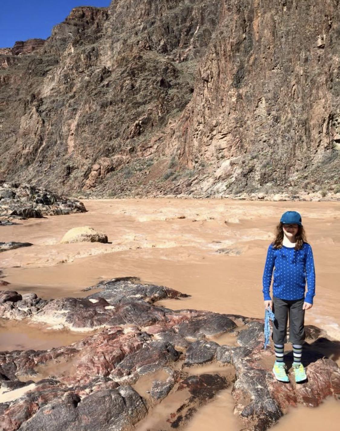 The park service of course has a sampling bias about stupid hikers. The Havasupai Gardens ranger station alone has 600 rescues a year (mostly an unplanned nights rest, food and water so they can complete their “day hike” under the own power, if not on their original plan).
- You must be logged in to reply to this topic.
Forum Posting
A Membership is required to post in the forums. Login or become a member to post in the member forums!
Trail Days Online! 2025 is this week:

Thursday, February 27 through Saturday, March 1 - Registration is Free.
Our Community Posts are Moderated
Backpacking Light community posts are moderated and here to foster helpful and positive discussions about lightweight backpacking. Please be mindful of our values and boundaries and review our Community Guidelines prior to posting.
Get the Newsletter
Gear Research & Discovery Tools
- Browse our curated Gear Shop
- See the latest Gear Deals and Sales
- Our Recommendations
- Search for Gear on Sale with the Gear Finder
- Used Gear Swap
- Member Gear Reviews and BPL Gear Review Articles
- Browse by Gear Type or Brand.
