Topic
Geraldine Largay
Forum Posting
A Membership is required to post in the forums. Login or become a member to post in the member forums!
Home › Forums › General Forums › General Lightweight Backpacking Discussion › Geraldine Largay
- This topic has 72 replies, 29 voices, and was last updated 8 years, 6 months ago by
 Tipi Walter.
-
AuthorPosts
-
May 27, 2016 at 7:42 pm #3405137
It is just tragic to me imagining her starving in her tent – whether she lasted exactly 26 days or became disoriented about the passage of time towards the end is moot. Even more sad that she had a SPOT she was paying for and didn’t bring it.
My first thought was the stereotype of thru-hikers that lack orientation skills and depend on the reliability of just going from one white blaze to the next. I personally don’t think companies should even be allowed to sell those dinky compasses on the temperature tags – totally useless. While I take for granted my strong sense of direction and have never used GPS, developing orientation skills (and I include basic awareness like looking back when you walk off trail to make special note of landmarks) are as important as any other skill like pitching your tent properly, being able to build a fire, avoiding hypothermic conditions, etc.
May 27, 2016 at 9:53 pm #3405148 AnonymousInactive
I agree with a lot of what folks are saying here about learning basic orientation skills etc.
But speaking as someone that seems to have been born with a severe lack of good directional abilities–you probably don’t realize how difficult it is for someone who has a innate deficit in that area.
Interestingly though, on occasion while being lost, i kind of turned my intellectual/analytical mind down a lot, went within, used my intuition and was able to find my way. It was a similar process and feeling that i have used when i have tried to remote view targets (just a few occasions). Except that the former could be explained by sub/un-conscious memory, while the latter can’t.
Anyways, back on subject, my spouse on the other hand, has excellent abilities in this area. She is really, really good at remembering landmarks, features, etc. Perhaps not too surprising since she’s in a female body and is a long time artist. She happens to be currently reading The Lost Art of Reading Nature’s Signs by Tristian Gooley, which brings this subject to a whole nother level. This guy would make someone like Skurka’s directional abilities, seem like child’s play in comparison, it would seem.
May 27, 2016 at 9:59 pm #3405151You’re likely right, I frequently have a hard time understanding how certain people manage to get themselves into what seem to me absurd situations. And I don’t mean that in an attempt to sound superior or make anyone feel bad for finding navigation challenging—it just is something I do find hard to understand. I hear stories of people who get lost in my area and have to be rescued by local SAR and it’s almost always a situation I can’t comprehend at all. It seems for at least some people I’ve tried to work with that they have an active mental block they put up to avoid learning about it because they tell themselves they’ll never be able to figure it out. To the point I can roll out a map and show them landmarks in person and on the map and you can just see when they give up internally and stop trying to even understand. Fortunately, after several rescues, those people have stopped hiking solo.
May 27, 2016 at 10:04 pm #3405152The Lost Art book looks really interesting.
The use ESP to save yourself if you can’t use a map & compass advice, not so much.
ETA:
I almost bought the Lost Art book, but after reading some of the reviews I went with another one instead, Finding Your Way Without Map or Compass by Harold Gatty. This seems much more practically oriented, and the guy has some impressive credentials. Just starting it on Kindle.May 27, 2016 at 10:10 pm #3405153Some people do not have the right mindset to view a map as others do. The key then is to learn the mechanics of navigation.
I have loved maps since a child and to me they have always been connected to the ground itself. I can see the terrain in my mind as I look at a map.
i used to hike with someone trained by the British Army, and for him navigation was a mechanical discipline of bearings and tracks and declination as so on.
if it is a natural weakness and you are not prepared to learn it in a disciplined way then you should probably be aware of the risks of hiking alone and invest in a couple of fallbacks.
Having said all that I do realize in not infallible and will take a gps along even if only to get a fix of where I am on the paper map should I get lost. It has always remained in my bag up to now. I also use an Inreach.
May 27, 2016 at 10:29 pm #3405155AnonymousInactiveHi Jonathan,
I can’t speak for others, but in my case, it’s partly from lack of use, i think. I spent the first 20 years of my mid 30 years being extremely inward focused–think like moderately autistic, though i’m not sure or not if i would technically have fallen under that category. Combine that with a lack of being able to go places much of the time, for various reasons, didn’t help.
Certainly wasn’t it recommending it to others Ralph, but just noting out loud some of my experiences. Such experiences and hearing about them, seems to bother some folks. Cognitive dissonance i guess.
I plan to take some orienteering classes to at least learn the basics. But what happens if the map and/or compass gets destroyed or lost? Or landmarks, etc become useless? For me, it’s nice to know that i have another backup that is not reliant on anything physical.
May 27, 2016 at 10:54 pm #3405164I would describe a lot of my early years as being very inward-focused as well—however, I did have the opportunity to wander alone in the woods around my house regularly between the ages of 5 and 15, which likely helped with development of subconscious navigation skills and sense of direction. In the past 8+ years I’ve been a regular contributor to the OpenStreetMap project, and I’ve found that the thought processes involved in creating a map (even if from GPS data sources) and frequent reading of aerial imagery has helped me be able to rapidly create mental models of an area from maps and other such information. Much of the negative opinions people have of GPS units seem to come from how certain people utilize them, but to me they’ve always just been a map (which may or may not be accurate, same as with a print map) and a tool to tell you where you are on that map. Whenever possible, I use my own maps on my GPS—even when visiting an area for the first time I’ll often create a map in advance from various public sources, trails aligned to aerial imagery when possible to bring them more in line with reality, etc. and not only does it end up generally being more accurate than existing sources, the process helps me start building that mental model of the area before I even get there.
May 27, 2016 at 11:10 pm #3405167AnonymousInactiveThank you for sharing Jonathan. Certainly i would like to get better at this, and become more like folks like yourself.
May 28, 2016 at 7:47 am #3405200This story is so sad because there are fifteen ways that could have prevented what happened, all mentioned here. I would like to also note the false sense of security some gain from “The Trail”, like it is some safe passage that does not qualify as wilderness. I started in the Sierra where one followed trails, but they were always clearly subsets of wilderness. Most of the ill-equipped people I meet are embolded by a false sense of security because The Trail in their minds is tame and does not intimidate like the thought of venturing into the wilderness.
May 28, 2016 at 8:00 am #3405201I’m one of those people with really good internal navigation skills – I always seem to know which way is north, I have a near-photographic memory of places/landmarks – and yet I ALWAYS carry a map and compass. Even a teensy little cartoon map of some well-known trails (ie the Manistee River Loop in MI comes to mind…) at least gives me a general direction and general locations – in case I need to walk in a direction to get to something.
What I take from this very tragic -and likely avoidable- tragedy is that ANYONE can get turned around. Just because I have a really good sense of direction and location doesn’t mean I still can’t lose my bearings one day.
That still doesn’t really explain the next 26 days tho……..if she really was just a half-mile from the trail, did she really not hear the searchers? helicopters? nothing? there is definitely something about this story that doesn’t make any sense.
May 28, 2016 at 8:18 am #3405204I have to agree with that. 26 days and no attempt to self-extract?!
A couple of times I’ve had the thought that Billy mentioned above… some sort of dementia (added to the symptoms of getting lost, flustered, and adamant about not learning compass, forgetting the SPOT), or perhaps some other injury that prohibited movement.
May 28, 2016 at 9:04 am #3405211but i feel that some practice with someone knowledgeable would be of more help in a practical sense.
This is key! Nothing like getting out and actually using it, matching map to land and discovering the incredible utility of the compass.
I went through USAF survival school near Spokane, WA in 1977, where we bushwhacked for 6 days straight using map and compass, day and night, all while very hungry and stressed and drinking iodine-laced swamp water. All sorts of fire building and shelter construction (from parachute panels) and food gathering instructionals at the same time. I was stung by yellowjackets about 15 times. It was the most miserable and enlightening experience I’ve ever had, because something learned under such duress is not easily forgotten.
May 28, 2016 at 9:30 am #3405214PS, Justin, a thought that just occurred to me…
Since you sew a lot of stuff you probably already have the gift, or have learned the skill, of visualizing 2-D patterns in 3-D. I would imagine there is some correlation there with reading topographic maps.
May 28, 2016 at 11:48 am #3405231Douglas Peacock–aka Hayduke in Ed Abbey’s books–writes in his own book about the time he went down to a lake at evening to get water and couldn’t find his tent afterwards as night fell. He did, eventually, but it was hair raising, he writes..
I was glad to read this because the exact same thing happened to me. After 50 minutes of bewildered searching, I found my tent. It HAD to be there…and yet it wasn’t…and yes, I became a bit anxious.
In those long ago days I often packed a little weed on my trips. this may have played a part.
May 28, 2016 at 12:49 pm #3405239“In those long ago days I often packed a little weed on my trips. this may have played a part.”
That would do it… surprised you made it out of your tent and down to the lake :)
billy
May 28, 2016 at 12:58 pm #3405242Oh no, I wasn’t in my tent, but always outside exulting in the “mind blowing” beauty of it all…of course, the very phrase “mind blowing” should have been a warning sign…
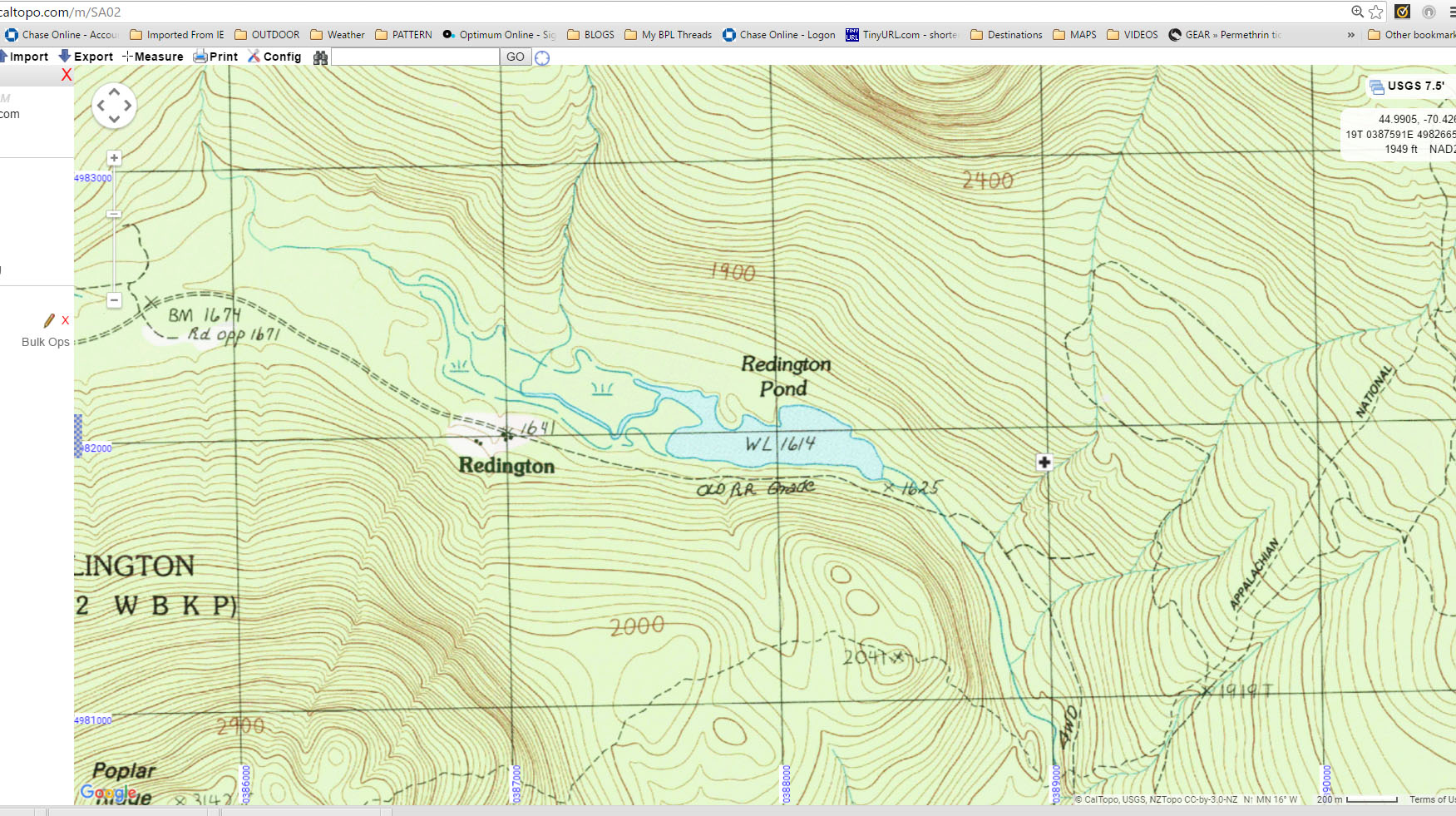
May 28, 2016 at 1:17 pm #3405248Looking at the maps of Largay’s location provides a poignant reminder of the simple technique, when all else fails, of following drainages downhill.
Below is a Caltopo map with the “+” marking her location as closely as I can interpret looking at the SAR tracks and another map of her ultimate ‘found location.’ She was only about 300 meters from a 4WD road, maybe a bit more, but not much.

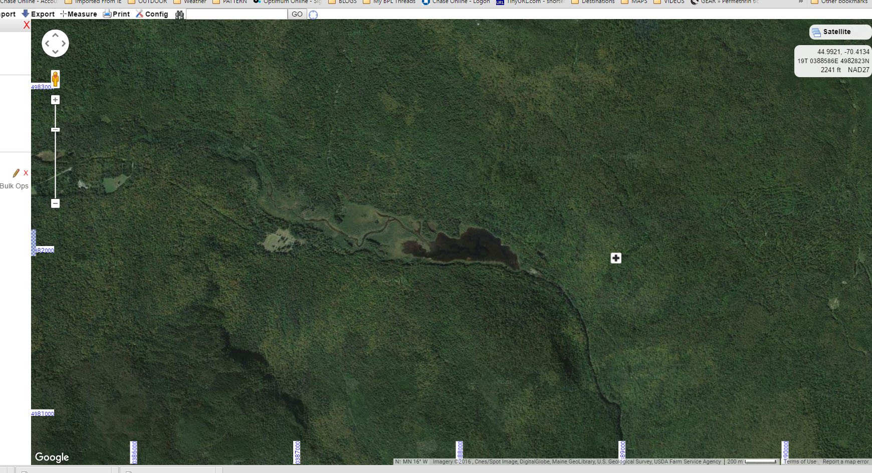
And next is the Google Earth satellite view, clearly showing the 4WD road not far away (also on the Caltopo map above)
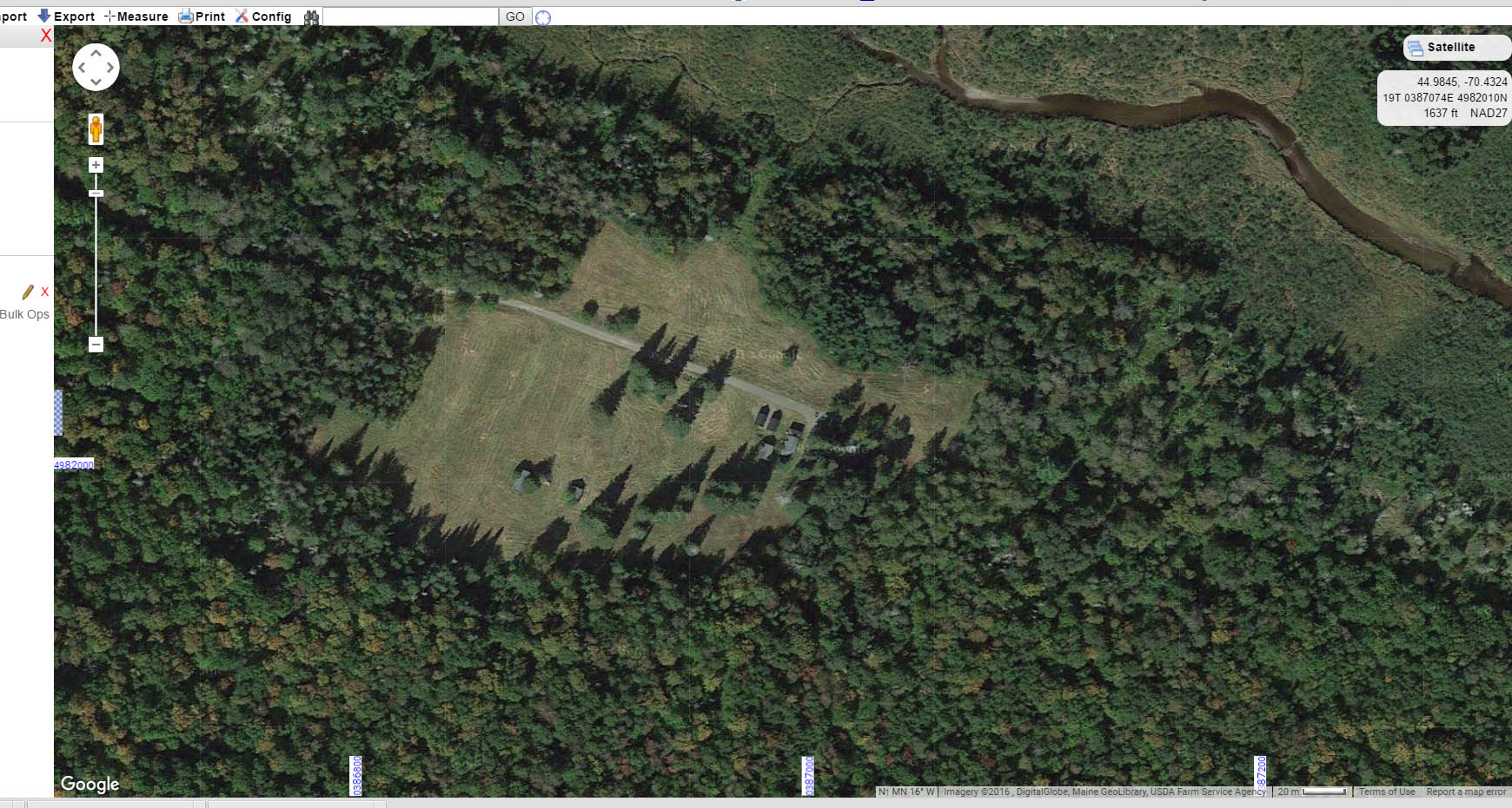
Proceeding with the technique of following the drainage down would have very quickly and easily brought her to this house or homestead…
And when you examine the topo map for that area, virtually every drainage in that area would have ‘funneled’ her to this location if this technique had been followed.
May 28, 2016 at 5:21 pm #3405289I question the 26 days bit. You can’t last that long without water. You can’t last more than a couple of days without water. You can last a bit longer without food. Was she by a creek? Maybe.
I suspect she may have been aberrating a bit in her panic and confusion. That might explain why she never bothered to light a signal fire. Or to simply reverse the direction she had taken on leaving the trail – going uphill after going downhill, or V/V. And why she lost track of time. As to why she never heard the searchers – I have no idea.
Otherwise, I suspect her actions are so inexplicable that most of our theorising is futile. All we can do is to check our own actions.
Cheers
May 28, 2016 at 6:10 pm #3405297She was by a creek, and she wrote in her journal that she tried unsuccessfully to light a fire.
May 28, 2016 at 6:53 pm #3405311Consider this quote from an article about this tragedy at CNN’s web site:
“She had traveled with a good friend, Jane Lee, until June 30, when Lee had to go home for a family emergency.
<div class=”zn-body__paragraph”>Lee told investigators that she was concerned about Largay hiking alone. Largay had a poor sense of direction and several times had taken a wrong turn. Once, Lee, who was a faster hiker and would sometimes go ahead then wait for her companion, said she had to double back and find Largay. The elder hiker had been walking the wrong direction until someone helped her get oriented.”</div>
<div class=”zn-body__paragraph”></div>
<div class=”zn-body__paragraph”>So, basically, we’re dealing with someone who did not have enough spatial/directional understanding to stay walking the correct direction on a major trail. No wonder we’re having a hard time understanding this… because we’re trying to understand it from OUR point of view(s)… a point of view that entails some spatial/directional common sense. Clearly, she should not have been hiking alone… regardless of how many maps, compass, and gps devices she could fit into her pack.</div>
<div class=”zn-body__paragraph”>Billy</div>May 28, 2016 at 7:34 pm #3405319Billy, I am ever more convinced that your assessment is the only viable explanation.
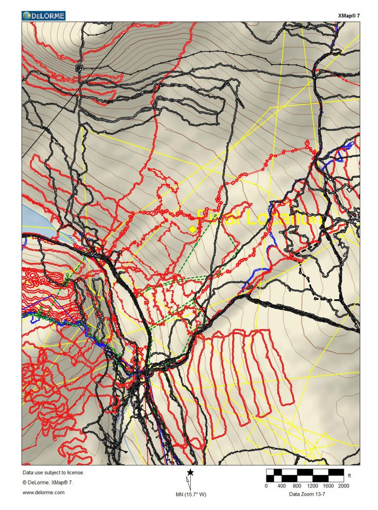
Below is a map of SAR GPS tracks recorded during the search, and they were obviously patrolling that 4WD road on a regular basis, and obviously used that road to motor-transport SAR teams to the search area.
From only 300 meters away, certainly all that hubbub would have been heard and somehow responded to by shouting or blowing a whistle (although I don’t recall a whistle on the inventory) or simply moving in the direction of the sound.
May 28, 2016 at 9:01 pm #3405333she wrote in her journal that she tried unsuccessfully to light a fire.
She had a box of matches, a paper notebook, and two Bic lighters, and she gave up trying to light a fire? For days on end?
Given the way that search party crawled across that area, where was she while they were searching? I doubt that the search parties were all that quiet either (I know we weren’t). Something strange there.
Incidentally, that is an excellent use for a GPS: to map out the searched area. Really smart. I learn something new.
Cheers
May 28, 2016 at 9:34 pm #3405337In 2010, a HikeArizona member, gpsjoe, went missing in the Mazatzal Wilderness and HAZ members made a similar map of the routes they’ve taken to search for him.
He has still not been found, 6 years later.
May 28, 2016 at 10:34 pm #3405354Something strange there.
Firebuilding, like navigation, is also a skill. I can see someone trying to light pieces of wood that are too big, or wet, or similar, and eventually giving up. (Especially if they are the sort to get flustered easily.)
Only three dog searches were made of that area, apparently due to a lack of volunteers who were fit enough, so her camp was likely passed only once or twice. One of the articles shows she had a whistle on her shoulder strap, but I would assume her journal would have noted hearing a search time. Napping in her tent would have easily muffled sound from 100m, and even without considering hearing loss with age, she could simply be the type to not notice (pin down) a distant sound.
However, she also did what many people are told to do when lost: she stayed put and waited for someone to find her.
In 2010, a HikeArizona member, gpsjoe, went missing in
An ironic choice of handle there.
-J
May 28, 2016 at 11:29 pm #3405365There’s some speculation on other forums that she perhaps did not want to be found…..at least initially. Maybe she changed her mind later?
-
AuthorPosts
- You must be logged in to reply to this topic.
Forum Posting
A Membership is required to post in the forums. Login or become a member to post in the member forums!
HAPPENING RIGHT NOW (February 11-21, 2025) - Shop Hyperlite Mountain Gear's Biggest Sale of the Year:

Our Community Posts are Moderated
Backpacking Light community posts are moderated and here to foster helpful and positive discussions about lightweight backpacking. Please be mindful of our values and boundaries and review our Community Guidelines prior to posting.
Get the Newsletter
Gear Research & Discovery Tools
- Browse our curated Gear Shop
- See the latest Gear Deals and Sales
- Our Recommendations
- Search for Gear on Sale with the Gear Finder
- Used Gear Swap
- Member Gear Reviews and BPL Gear Review Articles
- Browse by Gear Type or Brand.
