Introduction
Because of COVID-19, visitors from all over the province and the rest of Canada have inundated my mountain hometown. Many of the visitors are first-time adventurers and are failing to follow the basic safety protocols. Sadly, this has frequently resulted in environmental damage, abandoned garbage, vandalism, the death of more than a few habituated bears and other wildlife, and multiple accidental deaths of humans who lacked the knowledge and experience travel safely in the wilderness.
Never in the history of this little area have there been more search and rescue calls, and emergency services are overwhelmed with what I can only chalk up to human error, stupidity, or inexperience.
On top of finding COVID-19 distressing, the influx of ill-equipped and disrespectful users of my backyard is incredibly demoralizing. Paddling for at least a day to an inaccessible mountain ridge is my preferred coping strategy to avoid crowds.
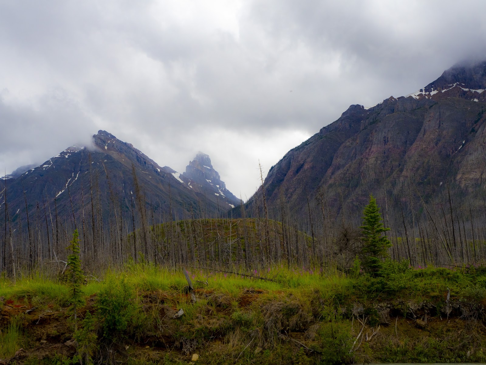
Several years ago, I spotted a mysterious looking ridge across from Highway 11 and the North Saskatchewan River. Everything in me wants to follow that ridge to its source somewhere deep in the mountain range. The ridge is almost entirely inaccessible except by canoe, an unmarked long-distance hike, a helicopter, or perhaps on horseback.
To my chagrin and begrudging amusement, the topographical map identifies my dream ridge as Corona Ridge, and the creek that empties into the North Saskatchewan River is called Corona Creek. It’s too much of a coincidence to ignore. Corona Ridge becomes my destination to avoid the news, noise, people, and COVID-19 in my home mountain range in 2020.
Logistical Notes
Corona Ridge is an infrequently (possibly never) traversed valley located on the North Saskatchewan River’s southern banks. To get to those southern banks, I either have to paddle across the river or hike two days through what could be a washed-out or blockaded trail. In 2009, a prescribed burn near the valley blazed through the area to create a fire break between the uncontrolled forest fires and the pine beetle infestation in nearby Nordegg, Alberta.
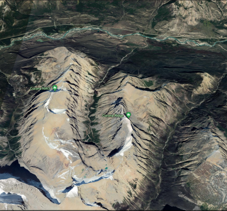
I have chosen to canoe a section of the North Saskatchewan River and hope that the prescribed burn on Corona Ridge has not made Corona Creekbed impassable. Since this is an untraversed route (as near as I can tell), I have no trip reports and no way of knowing if Corona Creek reaches an impassable headwall further up Corona Ridge.
From Google Earth and Gaia GPS imagery, it appears the creekbed is passable up to Corona’s headwaters, and it may well be a glacial lake fed by a permanent snowcap near Corona Ridge.
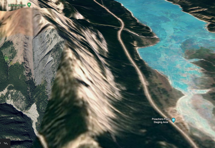
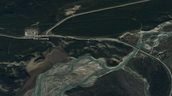
Paddling into Corona Creek also means planning logistics for canoeing and shuttling the canoe from Preacher’s Point, Clearwater County, AB, to the Highway 93 Bridge South of Saskatchewan River Crossing. It is essential to note that this shuttle requires a National Park Pass for both vehicles.
It would be possible to kayak this section of the river, but most white water kayaks do not have enough storage and flotation for even ultralight gear and food on multiple days of backpacking. However, paddling to a trailhead solo makes shuttling between staging areas incredibly tricky and logistically challenging.
Travel Style
Canoeing to a trailhead, with rare exceptions (solo canoeists), requires at least two skilled paddlers and a whitewater canoe. Since we have two canoeists and two backpackers, travel style is a shared equipment trip.
My trip companion, Michael, is a whitewater rescue tech, firefighter, paramedic, and trail runner, which means I am passing on the trauma kit and letting him do his thing. However, I am packing a few personal items like blister care and bandaids (medics are notoriously austere with comfortable minor injury care).
Equipment Notes
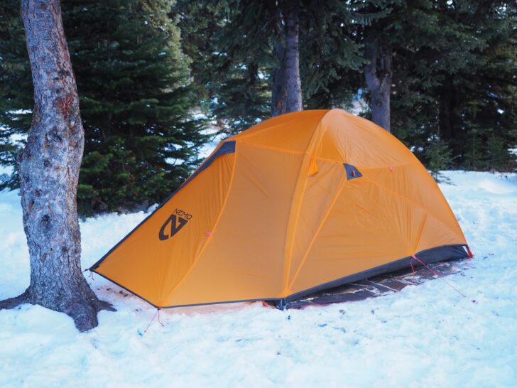
On this trip, I’m testing out Nemo Equipment’s Kunai 2P four-season tent (spoiler alert: thank goodness). It’s not the lightest summer tent on the market, but in the Canadian Rockies, it might be the best tent I’ve tested for all-weather conditions. In the Canadian Rockies, you can reasonably expect all four seasons in a single day in August, and I was thrilled to get my hands on a four-season, well-thought-out tent. I have a full review of this tent coming up at BPL soon!
I recently picked up the Sea to Summit Ultra-Sil Nano Daypack for summiting missions. With its long list of unknowns and potential for scrambling above Corona Creek’s headwaters, Corona Ridge makes an ideal testing ground for the little egg-sized summit pack. I decide to bring it along as well.
I am also cleaning out my abandoned cupboard where my mountaineering guests leave backpacking meals they don’t use or want to take home. I also put my discounted commercial backpacking meals as an emergency-get-out-of-the-house meal when I don’t have something homemade on hand. I’ll give micro-reviews on a few flavors from my pantry’s reject pile and let the readers know what brands and flavors I would buy at full price and what I would toss before opening.
Photo Journal
Day 1
With months of COVID-19, and political and economic instability influencing my workdays, I haven’t been sleeping well. Lack of sleep and needing a reset is a perfect reason to get out of cell service and away from light pollution – me not sleeping continues into the night before leaving on the Corona Ridge. I finally fall asleep around midnight. I wake up at 2 AM and then again at 4 AM. At 6 AM, I wake up with a throbbing headache and stumble out of bed, groggy and disoriented. This is not the start of my day I had imagined.
I load my gear into my car and double-check all my river equipment before setting off down the highway towards Preacher’s Point. Michael follows me out, canoe in tow.
After about an hour on Highway 11, I pull into Preacher’s Point and park my car, unload my gear into Michael’s SUV, and hop in beside him for the remainder of the journey to Saskatchewan River Crossing Bridge.
Member Exclusive
A Premium or Unlimited Membership* is required to view the rest of this article.
* A Basic Membership is required to view Member Q&A events

Discussion
Become a member to post in the forums.
Longtime Backpacking Light author Emylene VenderVeldon takes on a suspiciously-named untraversed route, one of the most difficult she’s ever attempted.
Wonderful story, thanks!
Sometimes Type 2 fun is the best of all, especially sandwiched between real fun on the river. And escaping our current, multi-level, world-wide Type 3 fun.
Reminder to self: bring the caffeine, bring the caffeine, bring the caffeine.
— Rex
Emy,
I’m glad you volunteered for this assignment, and that I didn’t assign it to you 😂
But on a serious note:
I’m so proud of you right now I can barely contain myself!
Thank you for sharing your adventure Emy.
This was a very complicated off trail multisport adventure. Its great you have a hiking partner that is up for this. You both rock!!
All the best
Great trip report! Really enjoyed your story. I use neoprene socks for those stream crossings and keep my boots on! I guess with heavy mountain boots you don’t want them wet though. The color of your feet is indeed … interesting!
The wilderness as a safe or anchoring place. Love this theme.
Dear Emy, thank you so much for sharing your “never been so alive” adventure, landscape, feelings, progress data, and detailed gears list down to grams, etc.! Reading it for the second time now. Best wishes to you for the end of 2020 and whole 2021!
@Rex that is now question number one on my trips. I think the lack of coffee was the worst part 😂.
@Ryan 😂 I might have quit working here if it had been an assignment 😂 kidding… barely.
@granolagirlak if it’s not deeper than ankle deep and I’m not traversing on a slope I usually keep my boots or shoes on. It’s a bit of a toss up if keeping shoes or boots on is safer though. A shoe or boot can keep your foot from getting sliced on sharp rocks. In this case the footing on the bottom was slick and smooth. Wearing a sole was pretty treacherous because I couldn’t feel my way across parts with good traction. Albeit half way across I also couldn’t feel my feet so…. toss up.
In this case, no matter what footwear I had on, it needed to be dry for walking on the scree slopes at an angle right after the creek crossings. Wet screw traverses are my personal worst enemy in any footwear. Even in proper, dry, mountaineering boots my feet were all kinds of blistered and beat up. My boots were heavily scared and shoes would have been completely shredded. I had bought a pair of shoes at the beginning of the 2020 season and I was so glad I left them home on this trip because at least I still have a pair of shoes and a pair of boots.
A big thanks to everyone else who is enjoying the entertainment value of my somewhat botched attempt at a working ‘holiday’
Ah, the lure of a distant ridge or hidden canyon. I totally identify. Thanks for taking us with you on a trip to Booger Country.
This was just great!! Some whitewater action mixed with backpacking and camping while exploring the unknown!! You are my hero and I am envious of your adventure!! Thanks for posting this!! I would recommend trying Peak Fuels breakfast skillet..not much else I can say, you had it all covered!!!
Canoe-accessed backpacking, very nice! Thanks for the trip report.
Great trip report. Loved it.
I will applaud you for becoming a socially adapted introvert. I took a wrong turn at Albuquerque and became an obnoxiously adapted introvert, a mistake that hasn’t served me or people within earshot all that well.
😂 I am certain there are people who would say I resemble that description as well! Mind over matter, the people that matter don’t mind, the ones that mind don’t matter 😂
Become a member to post in the forums.