Topic
Wind River Loop with Knapsack Col – Green Lakes or Elkhart Park?
Forum Posting
A Membership is required to post in the forums. Login or become a member to post in the member forums!
Home › Forums › Campfire › Trip Planning › Wind River Loop with Knapsack Col – Green Lakes or Elkhart Park?
- This topic has 22 replies, 5 voices, and was last updated 7 months, 1 week ago by
 Al K.
Al K.
-
AuthorPosts
-
Jun 26, 2024 at 11:42 am #3813997
I am planning on flying into Salt Lake City and have 4 trail days (possibly 5 days) for a Wind River Loop around July 25th. Previously I have done a long loop covering the Cirque of Towers area and I did a little day hiking by Green Lakes so I saw the views from afar of Square Top Mountain. Now its time for Titcomb Basin and Knapsack Col. I typically do 12-15 miles a day at 9-12k altitude and sometimes more if terrain is favorable and/or needed to squeeze a trip in.
In terms of Knapsack/Titcomb, is there a better way to approach it? I’ll be bringing trekking poles – is microspikes needed? I don’t own and have never used crampons or ice axe though I am good with route finding and comfortable with off-trail. I have come down the steeper side of Haily and Texas passes and found them quite steep but manageable. Any other considerations for Knapsack Col?
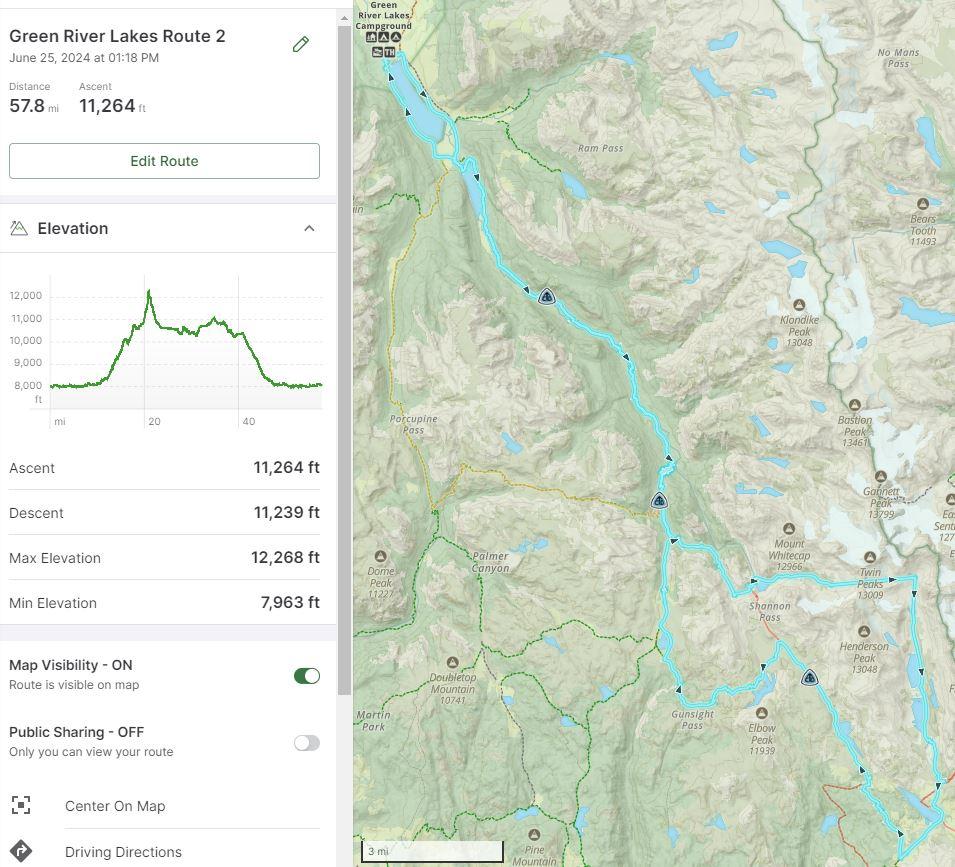
I have four routes options of varying lengths all pictured below and I don’t plan on returning to the area anytime soon. Which is the best?
1) Start at Green Lakes and end Elkhart Park with Indian Basin day hike – I rather avoid the time and cost involved with a car shuttle unless this is the definitive way to go
2) Elkhart Park Loop – benefit is shortest loop option and drive with day hiking in Indian Basin
3) Green Lakes Loop – Return via Green Lakes Trail (as pictured below) – benefit is Green River approach; con is an extra hour of driving each way and coming back on a lot of the same trail
4) Green Lakes Loop – Return via New Fork/Porcupine – benefit is Green River approach and new trail on way back; con is an extra hour of driving each way and mileage might be too steepThanks in advance for any advice!
 Jul 19, 2024 at 5:36 pm #3815176
Al,
I won’t speak to the Col since I’ve never done it, but if it’s been a good snow year there could be a sizable cornice to deal with. You seem to consider Green River approach as beneficial but I don’t see a reason why. I’ve been up that approach as far as Tourist Creek at least and used that drainage to reach the Divide. It was fairly standard river valley to that point at least.
I’d go in Elkhart personally and have been on half of the route you show. I’d planned to do the eastern half from Indian Pass back to Photographer’s Point but my son who was 7 at the time wanted to get back home to mom. :) Not sure if they would be any help but I have videos of my trips on YT (link in my profile and look at Playlists). Be prepped for significant bugs.
Jul 23, 2024 at 3:16 pm #3815306Personally I think coming in from Green River Lakes is more scenic but the convivence of Elkhart is nice.
I’ve done it a few times but all in August. Twice I’ve had little to no snow, but one year there was significant snow on the East/South side of the pass and we used microspikes. It could have been done without them but we were carrying them for Knifepoint Glacier anyways. The normal route on the East/South side is though some large talus on the climbers right of the pass itself.
I’ve gotten snow in WRR twice in mid August, so be prepared for anything.
Jul 23, 2024 at 3:17 pm #3815307 Jul 23, 2024 at 7:50 pm #3815327
Al K – let us know how the conditions are Knapsack Col and Titcomb basin etc…we are starting Aug 10th from Green Lakes and following Dixon’s WRHR. I am most interested in snow conditions and how bad it is. I will taking micro spikes which I think is a good idea.
Jul 24, 2024 at 6:01 am #3815336I decided to pony up for shuttle and going via green river lakes. Still undecided on micro spikes. If i do not report back with knapsack col conditions by 7/31 then respond to this post as I get notifications.
Aug 1, 2024 at 7:09 am #3815785Hey AI K – just a reminder to respond back with how the snow levels look – hope you had a good trip!
Aug 1, 2024 at 8:08 am #3815787Thanks for the reminder. I got back from my trip yesterday morning.
I did Knapsack Col Sunday July 28th. No micro-spikes needed.
Aug 1, 2024 at 8:39 am #3815789Longer answer/update. We went from Trail Creek Park to upper Titcomb Basin (above the lakes) in one day. Was hoping to get closer to Island Lake but one of my hiking buddies showed up out of shape so it was a long slow day. Still probably toughest day I have ever had with intermittent sun and frozen rain. Between Vista Pass and Peak Lake there is a long gnarly section of boulder hopping as well as a section navigating around Peak Lake. Relatively easy and straight forward cross-country hike until you get closer to Knapsack Col at which time it gets much steeper and you have to be careful again with the rocks you put your weight on.
Once I summited and enjoyed the views I had a bit of a panic because I couldn’t find the “trail” down. It seemed the entire Col/Pass on the Titcomb side was snowed over and extremely steep (so no glissading). I even started to rock scramble a bit on the north side of the Col without my pack to see if I could find an alternative way down – I came back a bit defeated as it was pretty sketch and I wasn’t sure I wouldn’t be cliffed out at a certain point. Thankfully my brother was looking around and found on the northern most edge of the Col just passed a bit of snow there was a way down that was not snow covered. It was hard to see from the top without peering over the edge/snow but it was definitively the way down (vs my rock scramble a bit further north). The way down was very steep with rocks of all sizes – always have three points of contact and test rocks for looseness. Very slow going until we were able to hop over to a long snowy section at a suitable angle to walk. Mostly a regular cross-country trek from there on out to the Titcomb Lakes.
My suggestion for a regular backpacker who likes some off trail route finding, scrambling, and excitement with good knees is to only go to the Knapsack Col once its definitively known a section of snow has melted out on the Titcomb side. If not definitively known and you still want to give it a try, then go up Knapsack Col from Titcomb Basin so you can see if there is a way up and turnaround before if not (the Peak Lake side of Knapsack Col will melt out way before Titcomb side). It would be very disheartening if you went all the way up from Peak Lake to turn back.
Aug 1, 2024 at 8:44 am #3815790approaching Dale Lake (from Vista Pass)
Aug 1, 2024 at 8:49 am #3815791The “trail” around Peak Lake (go up above the lake and then a bit of scramble back down to shore line to get back up again – great swimming spot if you have time). From Cube Rock/Shannon Pass side it appears there is no way around Peak Lake but just follow the trail and it will be fine.
Aug 1, 2024 at 8:52 am #3815792Cross-country on the way to Knapsack Col
Aug 1, 2024 at 8:53 am #3815793Only a bit of snow on Peak Lake side just before Knapsack Col (could of skipped it but it was easier than the rock hopping)
Aug 1, 2024 at 8:55 am #3815794Top of Knapsack looking out to Titcomb side
 Aug 1, 2024 at 8:55 am #3815795
Top of Knapsack looking out to Titcomb side – part two
Aug 1, 2024 at 8:57 am #3815796the scramble down Knapsack on Titcomb side
Aug 1, 2024 at 8:59 am #3815797relief found in the snow
Aug 1, 2024 at 8:59 am #3815798Titcomb lakes in view
Aug 1, 2024 at 9:00 am #3815799a windy home (above Titcomb Lakes)
Aug 1, 2024 at 9:16 am #3815800Wow! Nice…thanks for all the information – appreciate it. The pictures are amazing….can’t wait to get there!
Aug 1, 2024 at 9:43 am #3815801Awesome pictures – I’m glad you had a great trip! That’s certainly one of my favorites and I need to get back out there and do it again!
Aug 1, 2024 at 10:00 pm #3815821Awesome trip. I’ll be out there soon and looking forward to it How were the bugs? Was much going on in the way of mosquitos?
Aug 2, 2024 at 7:39 am #3815830We considered briefly camping at Three Forks Park but the mosquitos were bad. We continued up and camped at Trail Creek Park where it was much better. No mosquitos in upper Titcomb Basin though it was windy at time. A bit of mosquitos at Island Lake during dusk but not bad at all. We treat our cloths with Permethrin which really helps. Overall the mosquitoes on this trip were just a small brief nuisance.
-
AuthorPosts


- You must be logged in to reply to this topic.
Forum Posting
A Membership is required to post in the forums. Login or become a member to post in the member forums!
Trail Days Online! 2025 is this week:

Thursday, February 27 through Saturday, March 1 - Registration is Free.
Our Community Posts are Moderated
Backpacking Light community posts are moderated and here to foster helpful and positive discussions about lightweight backpacking. Please be mindful of our values and boundaries and review our Community Guidelines prior to posting.
Get the Newsletter
Gear Research & Discovery Tools
- Browse our curated Gear Shop
- See the latest Gear Deals and Sales
- Our Recommendations
- Search for Gear on Sale with the Gear Finder
- Used Gear Swap
- Member Gear Reviews and BPL Gear Review Articles
- Browse by Gear Type or Brand.
