Topic
Printing maps Magnetic North Top of Map or Magnetic Lines/grid with CalTopo
Forum Posting
A Membership is required to post in the forums. Login or become a member to post in the member forums!
Home › Forums › General Forums › Philosophy & Technique › Printing maps Magnetic North Top of Map or Magnetic Lines/grid with CalTopo
- This topic has 14 replies, 6 voices, and was last updated 1 year, 1 month ago by
 Nick Gatel.
-
AuthorPosts
-
Jan 18, 2024 at 11:11 am #3801853
I am taking some beginner Scouts snow camping in a month and wanted to do some map&compass with them without bothering with declination. The old school way to do this was to take out a ruler, line it up with the declination line, and draw parallel lines on the printed map so the Scouts could align their compasses with the declination. There are also orienteering maps with Magnetic North as the top of the map (instead of True North or Grid North). So my goal is to print topo maps from CalTopo with Magnetic North top of the map OR with lines covering the map showing declination.
The CalTopo online documentation hits that these options are available as a “display options” but I cannot find them in the user interface displayed using my free subscription. Perhaps I need to upgrade to access more display features?? The question has been asked on the CalTopo user forum by other users but not answered. Has anyone cracked this nut?
Jan 18, 2024 at 12:00 pm #3801858I’m a “Pro” Caltopo subscriber and I’ve been using in since 2014. I think what you’ve seen in the User Guide is:
North Reference
Choose between true or magnetic north for your north reference. This will be reflected in the numerical heading displayed next to the crosshairs icon in the lower right corner of the map viewer.
That’s a setting for headings/bearings when using the Caltopo app on your smartphone. To my knowledge, there is nothing you can do to reorient a printed Caltopo to magnetic north rather than true north, or to draw new north-south lines on the map that are aligned with magnetic north.
I volunteer to run map & compass workshops for our local outdoors club in SE Michigan and I’m very familiar with the technique you’re talking about. We teach that technique as well. I’m also a member of an orienteering club, so I’m familiar with how their OCAD software automatically rotates the map to align it with magnetic north.
Unfortunately, I can’t suggest an easy fix for you. But I have two possible workarounds.
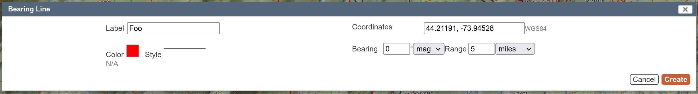
1) Create a series of “Bearing Lines”. If you right-click in the map, “Bearing Line” should be one of the options listed. You want the bearing to be 0 degrees and “magnetic” rather than “true”.

You’ll have to play with this. Once placed, it seems impossible to reposition them. But if you manage to make a series of parallel bearing lines that extend beyond the boundaries of the area that you intend to print, they seem to show up on the printed map as your new magnetic north-south lines just fine.
2) You could have Caltopo generate a PDF, use a tool to convert the PDF to a bitmap image like PNG or JPEG, open the bitmap image in a photo editing tool, and use the rotate option to rotate the entire map by [declination] degrees, and then clean it up by re-cropping the rectangle. It sounds like a lot of effort, but it’s probably only about 10 minutes of effort once you have all the right tools at your disposal on your PC.
Jan 18, 2024 at 12:17 pm #3801862My opinion — why not a couple classes ahead of time and teach them about declination since just about any map they will purchase or download will have true north at the top. Instead of a ruler and drawing declination lines, use a map protractor and only draw a line(s) to the destination. They are inexpensive.
Jan 18, 2024 at 12:56 pm #3801873Nick,
How does a map protractor account for magnetic declination when drawing a line from Pt A to Pt B on a map that’s aligned to true north?
There are several ways (that I’m aware of) to account for declination when measuring a bearing on a paper map and then intending to follow that bearing with a compass.
1) Use a compass with a declination adjustment. That’s what I do with my Suunto. I set the declination adjustment to the current magnetic declination and then forget about it.
2) Draw new north-south lines on the paper map aligned with magnetic north. When you use a protractor (or your baseplate compass as a protractor), the resultant bearing is now relative to magnetic north, not true north.
3) Use math to adjust the measured bearing value you get off the map to account for declination. The mnemonic we use is, “When going from map to compass: east is least, west is best. If you’re going the other way around, it’s the other way around.”
4) A variation of (1) – some compasses have a fixed declination scale rather than a declination adjustment. Once you’ve measured a bearing off of a paper map, you have to use the fixed declination scale to readjust your bearing to be relative to magnetic north.
Those are all the ways I know to deal with declinati0n.
Of the 4 methods, (1) is by far the easiest but most boy scouts don’t purchase the more expensive compasses with adjustable declination. I agree that with (2) you have to draw new north-south lines on each new paper map you work with. It’s not ideal, but given that you have to remember extra steps to employ methods (3) or (4), I think I would prefer (2) if I couldn’t do (1). If I’m in a situation where I’m under stress or fatigue, trying to remember extra steps creates additional opportunities to insert navigational error into the process. What if I add 10 degrees instead of subtracting? Now I’m TWENTY degrees off of my bearing!
I’m been volunteering to teach map & compass skills to other adults in our outdoors club since 2009. And the volunteers that preceded me were using method (2) for years before I arrived on the scene. It’s a tried and true method, particularly when you have a group of mixed individuals with different types of compasses, and different levels of learning ability.
Jan 18, 2024 at 2:23 pm #3801876Jeff,
Most inexpensive compasses under $20 have a housing that rotates, which is much better than the really cheap ones.
Using a map protractor we don’t need to orient the map and we don’t need to even lay our compass on the map.
Here’s an article I wrote several years ago on how to use a map protractor. The details on the map protractor are towards the end. It gets kind of detailed (hopefully no errors) in the beginning, but my philosophy is to teach magnetic declination and methods to navigate with any kind of compass.
I learned how to use a compass while in the military over 50 years ago. We trained in snow covered mountains, in rain forests and swamps. We used map protractors and military lensatic compasses, both of which I still use.
Jan 18, 2024 at 8:53 pm #3801892Thanks Jeff and Nick for the very thoughtful and detailed responses.
I will have only 15 minutes for this exercise before I let them loose to find the beginning of route. The Scouts have basic experience with orienteering maps and some geocaching. They will mostly have compasses with declination adjustments. For my own winter travel, I use paper maps for the reasons Nick lists in his very comprehensive article. So I will probably default to Jeff’s method No 2, which is what I learned years ago, and have used in the past with the Scouts.
Thanks for the help.
Jan 18, 2024 at 8:54 pm #3801893since the declination changes pretty much always, true north seems to me a better alternative for future map use than lowering the bar.
or … one might build quick like a bunny a set of lines in Pages/Illustrator or such, and set them at a jaunty angle, perhaps such as todays declination, and then before one prints his maps, just drop this gem of digital artwork on top of the map file. set the background color to “none” and all you’ll see is the lines over the map.
still, thru my eyes, going thru more work to appease the navigationally-non-gifted reeks of … i’d call it enabling if i was in a foul mood. i mean my goodness gracious, it’s all but using a template to build a website.
we were all doing pretty good until some softminded fool fell overboard, ran out of air whilst drowning, and during that oxygen deprived coma invented the automatic choke. but he was saved (sadly, it would prove), and now, 70 yrs later, we can’t read a compass.
ya’ll probably now have some idea of what going on a hike with peter v and nick is like.
Jan 19, 2024 at 6:33 am #3801911Nick,
I read your article. What your article describes is what ** I ** describe as
(4) Using a compass with a fixed declination scale (cheap $20 compass)
(1) Using a more expensive compass with a declination adjustment (Brunton Type 15, my Suunto M-3)
(3) Mathematically subtracting or adding the declination value to the measured bearing (east is least, west is best).
in that order. In some cases you’re using a map protractor (actually a combination map protractor and UTM plotter from Maptools. I have several different variants of their UTM plotters) to measure your bearing on the map, and other cases you’re using your baseplate compass as your protractor to measure the map bearing.
There’s no effective difference between what your article describes and what I describe, except that you don’t discuss option (2) drawing north-south lines on the map aligned with magnetic north, as discussed above.
Also, when you describe mathematically correcting the bearing for declination, you only discuss the case of going from the map to the compass. You don’t discuss what’s required to take a compass bearing (that you measured in the real world) and plotting that bearing line back on the map. Which as I said earlier, requires you doing the opposite of (east is least, west is best). Same with using the fixed declination scale on cheaper compasses.
If I’m standing on Long’s peak and I take a bearing with my compass to another interesting peak that I see to the northwest. Maybe there’s smoke coming from that peak and I want to report it to a park ranger. My compass reads 302 degrees. So now I want to plot that bearing line on my map to determine whether I was looking at Thatchtop or Arrowhead. I need to make the “reverse” declination adjustment before plotting the line on the map. That area has 8 degrees E declination. I need to add 8 degrees before using a map protractor (or my compass). (east is least, but we’re going the other way, so it’s the opposite). So the bearing relative to true north is 310. Oh – that’s Thatchtop peak.
I don’t know how to make the adjustment using a fixed declination scale compass, because it’s not a method we use regularly. I’m sure it seems straightforward once one reads how to do it. I’ve just never bothered.
But it’s confusing enough, that in the map & compass workshops I run through our outdoors club, we’ve decided to either (2) draw north-south lines on the map aligned with magnetic north or (1) recommend a more expensive compass with a fixed declination scale, with option (1) being by far our strongest recommendation.
I just checked the “Wilderness Navigation” book from Burns & Burns from Mountaineers Books. We also use this book in our workshops. When talking about mathematically adding or subtracting the declination adjustment, the authors write, “This is all very simple in theory but can be confusing in practice, and the wilderness is no place for mental arithmetic that can have serious consequences.”
The authors’ recommendation is to either (a) Get a more expensive compass with a declination adjustment or (b) to trim a thin piece of masking tape to a point, and put it on the rotating bezel at the current magnetic declination value. Then, when “boxing the arrow”, you now align the magnetic needle with the piece of tape rather than the orienting arrow in the bezel.
(b) Seems simple enough, unless that tiny little piece of tape falls off without you noticing, and then you forget. That’s why I don’t like that method.
I understand that with your military background, some techniques may be easier because you’ve used them and that’s how you were trained. What I’m saying is that for the people I’ve worked with (usually about 10-12 people per workshop, 1 or 2 workshops per year), some techniques are more confusing than others, and this is what we’ve found works for our groups.
Peter – your comments with phrases like “navigationally non-gifted” and “soft-minded fool” gives me the impression that you dislike making room in a wilderness environment for people who are trying to learn and/or don’t have the same abilities you have. Hike your own hike, man, and let others do the same.
Jan 19, 2024 at 7:02 am #3801912peter, you could add to that automatic transmissions. If people can’t figure out how to operate a manual transmission, they shouldn’t be allowed to drive.
and “get off my lawn”
and, since I’m off topic, I have to answer the on topic question – maybe just use the type of paper maps people would encounter in real life. Subtracting 7 degrees isn’t really that difficult.
does anyone actually use paper maps anymore??? does anyone drive a manual transmission?
Jan 19, 2024 at 7:57 am #3801913This will not solve your immediate problem, but it seems to me that any way you handle this, you will be discussing declination, so it’s not like you can totally avoid the topic. It would be ideal if your scouts could be advised to purchase a compass with adjustable declination. I checked on Amazon, and they are available for about $10, and I’m not really sure that any compass that costs less than that amount is worth owning. That way they would have a useful tool that they won’t regret buying, and I suspect that almost everyone would be happy to buy the recommended compass. If they don’t buy one with adjustable declination, it’s probably mostly because they don’t know any better.
Jan 19, 2024 at 5:35 pm #3801950There are several ways to navigate with map and compass. But whatever method is used, magnetic declination has to be completely understood. Understanding and compensating for declination is the part that many people struggle with.
Whatever method is used, especially when teaching others, it needs to be completely understood, accurate, and always repeatable by the learner/user.
I have found, even for myself, that map & compass skills can get rusty over time if not practiced periodically. I mostly hike off-trail and usually don’t need a compass. Full size USGS topo maps make navigation straight forward most of the time without a compass. USGS topo maps are what I use 99% of the time, although I do occasionally print maps with the long discontinued National Geographic Topo Map software. I have a printer that can print on 11″ X 17″ paper. USGS maps can now be downloaded for free and places like Staples can print full size copies.
I usually do a couple trips a year in difficult navigation terrain just to keep my map & compass skills sharp.
If we are going to rely on a compass & map for navigation, then a quality compass is a must have. This isn’t the piece of equipment to save money on. Even if the map and compass is a backup to some electronic device, periodic practice is a good idea, IMO.
Jan 19, 2024 at 6:42 pm #3801953Also, when you describe mathematically correcting the bearing for declination, you only discuss the case of going from the map to the compass. You don’t discuss what’s required to take a compass bearing (that you measured in the real world) and plotting that bearing line back on the map. Which as I said earlier, requires you doing the opposite of (east is least, west is best). Same with using the fixed declination scale on cheaper compasses.
Correct. It is in Part 2, about 1/2 way down the page.
And third article, Map Protractor Tips
Jan 20, 2024 at 8:02 am #3801965I did not realize that Staples could print full-size USGS maps. That’s very good to know! Do you bring the PDF file on a USB drive?
I have dozens of full-size maps for the wilderness areas that I frequent most, but it has been a long time since I added any to my collection. I used to have easy access to USGS maps, but those days are gone. We had a map store in the local shopping center that stocked a huge library of maps, and at that time there was also a USGS office down the road (I think it was in Lakewood?) that had all of them. When the USGS office closed to the public, the store purchased a printer. I could go in and ask for a map before going to the grocery store, and it would be ready when I was done with my shopping. Sadly, the store went out of business several years ago.
Jan 20, 2024 at 11:44 am #3801984digital maps at very reasonable cost on disk can be found at..
https://store.yellowmaps.com/collections/digital-maps?page=2
we, have found they stitch together pretty sweet in i-work/pages, and the older the version, probably the better. then one can rotate images at 1/10* increments, and that’s about a screen pixel. after one checks their printer alignment/registration, files are ready to print on waterproof paper. easy as pie.
at yellowmaps, can be found, like, the entire upper 2/3’s of Alaska for 30 bucks.
Jan 20, 2024 at 1:36 pm #3801996I did not realize that Staples could print full-size USGS maps. That’s very good to know! Do you bring the PDF file on a USB drive?
It has been years since I used Staples. I’m lucky that there is a map shop nearby. Been using them for decades. USGS maps are $8. I’d rather drive 9 miles and support a small business than use Staples. Plus the store has all kinds of interesting books, aerial pictures and other curiosities. Not sure, but they might be printing their maps in house now. They now sell stuff on the internet. Here’s a link to their site:
-
AuthorPosts
- You must be logged in to reply to this topic.
Forum Posting
A Membership is required to post in the forums. Login or become a member to post in the member forums!
Trail Days Online! 2025 is this week:

Thursday, February 27 through Saturday, March 1 - Registration is Free.
Our Community Posts are Moderated
Backpacking Light community posts are moderated and here to foster helpful and positive discussions about lightweight backpacking. Please be mindful of our values and boundaries and review our Community Guidelines prior to posting.
Get the Newsletter
Gear Research & Discovery Tools
- Browse our curated Gear Shop
- See the latest Gear Deals and Sales
- Our Recommendations
- Search for Gear on Sale with the Gear Finder
- Used Gear Swap
- Member Gear Reviews and BPL Gear Review Articles
- Browse by Gear Type or Brand.
