Topic
Lost Creek Wilderness loops of 40+ miles?
Forum Posting
A Membership is required to post in the forums. Login or become a member to post in the member forums!
Home › Forums › Campfire › Trip Planning › Lost Creek Wilderness loops of 40+ miles?
- This topic has 15 replies, 7 voices, and was last updated 7 years, 7 months ago by
 Michael Ray.
-
AuthorPosts
-
Sep 18, 2016 at 12:13 pm #3426833
Looking for something of at least 40 miles for my son and I to do next July. We’ll have 5 full days available. Would prefer something <= 10 mi/day, but he can manage 15 if he’s properly motivated (usually the last day) so maybe a max of 60 miles. Prefer to be above trees a lot though I don’t think that will be as easy at LCW. I know of a couple popular loops that are shorter, just wondering what the best options to extend it are.
Also, at the lower elevations, will we have totally missed most wildflowers the last week of July? We could do any week if needed, but this would also be some training for my mid-Aug trip.
Jan 2, 2017 at 6:48 pm #3442941Bump. I’m getting ready to set out our route now that I have the TI map. Also wanting to still hit some flowers though hopefully not a ton of bugs, which I assume will depend on snow melt. For now I’m penciling in July 17-21. Any ideas regarding higher routes or ideal week to go would be appreciated.
Jan 6, 2017 at 8:46 pm #3443555LCW isn’t really alpine, like you think of the Rockies. There are a few bald areas, which might technically qualify as “above treelike”, but really it’s mostly forrest/meadow hiking. Just aim for the higher altitudes in the region and you’ll still get views, though, if that’s what you are after.
Jan 6, 2017 at 11:10 pm #3443578May be awfully warm there by mid-late July. Late May to mid-June or so is prime LCW for the summer. And the fall of course.
The Zirkel or the Rawah Wilderness areas may be a better choice for your time frame.
Jan 7, 2017 at 8:55 am #3443595Heat doesn’t bother me. At least it won’t be hot AND humid like back home. ;) We could do it in June, too, if needed though I’d prefer to avoid major skeeters.
I choose LCW for 2 reasons. The very cool rocks and the speed of getting there and back (coming in via I-70). I realize there are a few other options that would be within a couple hours more perhaps. Others have suggested the Sangres. From the videos I’ve watched, I don’t think there are as many “play” opportunities for him there. I expect my son (10) will want to spend a day climbing all over McCurdy and/or Bison Peaks. Or going off-trail to try to follow Lost Creek. Too bad The Castle is such a bushwhack to reach! That is my focus – I want him to not just have to hike. I’m open to other ideas that would allow that and be fairly close to DEN/COS.
Jul 3, 2017 at 7:49 pm #3476909It appears from the USGS site that water levels are below normal near the Lost Creek area. Not sure if that is because it has been exceptionally hot or that it didn’t get the above avg snowfall the rest of the West did. Will we have any issues with water along our route detailed below? Would also appreciate any suggestions on campsites if there are any particularly enjoyable ones. Our plans have been changed so we only have 4.5 max days of hiking now. My current plan is to start at Ute Creek TH and deal with the stiff climb on the Ute Creek Trail. Then head north on Brookside-McCurdy > Wigwam > Goose Creek (with possible trip down to Shaft House area if time) > McCurdy Park > Brookside-McCurdy back to Ute Creek. Aside from the slower, steep start, this would put the cooler stuff closer to the end of the trip, which is important for him, being so goal-oriented. We will start next Tuesday morning.
Jul 4, 2017 at 10:03 am #3476954Hi Michael,
The loop you chose is a good one; it will allow you to see the “best” parts of LCW. The clockwise direction will provide a good dramatic structure to your trip.
The only thing I would change is the approach up Ute Creek. The trail is steep, hot, and dry and may not set the best tone for your hike. If you start at the Lost Park Campground, you could break into your trip with an easy amble through Lost Park before you tackle the tougher stuff.
You should be able to find water along the way for most of your journey. The exception would be the stretch of trail between McCurdy Park and Indian Creek. I have found an occasional trickle or some stagnant water up there but it’s not reliable in July. It’s easier to camp in McCurdy Park and/or the Indian Creek drainage and explore Bison Peak and McCurdy Mountain during the day.
Jul 4, 2017 at 11:27 am #3476963Dondo,
The main reasons for Ute Creek were closeness and no gravel/dirt roads. We’d be driving a Prius, which sits fairly low (lower than my Civic), coming North on I-25 and then leaving east (on I-70 eventually). If the road to Lost Park is good, I’d be fine with that change.
Jul 4, 2017 at 2:04 pm #3476985Ute Creek makes a lot of sense since you’ll be arriving from the south. The Tarryall Road is a good paved road and scenic to boot.
The Lost Park Road is a good dirt road that leads about 20 miles to the campground. I’ve driven it in a Civic and have seen other low clearance vehicles out there but can’t recall if I’ve ever seen a Prius.
Whichever way you go, I’m guessing that you and your son will have a fine adventure.
Jul 6, 2017 at 5:25 pm #3477408Michael,
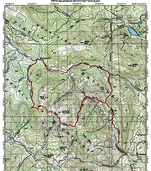
I just returned from doing the 27(?) mile loop illustrated here:

…minus the Goose Creek offshoot. I started at Lost Park. The dirt road is fine for passenger cars but feels interminable when you’re driving it.
The flowers were great. The streams indicated on the TI map are all flowing, and additionally, between McCurdy and Bison peaks, there was a small spring flowing right next to the trail — though this may be dependent on recent rains — and a pond that was just south of the trail, behind a rock outcropping in a marshy area. You could see it if you hiked a little west of it and turned back. I can’t imagine that will have dried up. In any case, between the peaks you get to a point where you can see willow-choked stream valleys dropping away on either side, and I imagine if you were desperate you could head a little ways down into either and find water.
The loop has both impacted and potential camping spots almost everywhere; there’s an unusually large number of naturally flat places, many with great views. McCurdy Park itself is very pretty. I camped on Bison Peak my third night. The sunset and sunrise were awesome. If I get my trip report done before your departure date I’ll post a link here.
Jul 6, 2017 at 7:02 pm #3477431How were the skeeters?
Unless the weather is bad, we’ll definitely camp up high.
Jul 8, 2017 at 6:22 pm #3477909I’ve put up the trip report on my blog at http://sedimentarylifestyle.blogspot.com/2017/07/lost-creek-wilderness-loop-trip-report.html.
The mosquitoes were bad — I put on my full raingear every time I stopped for more than a couple minutes. (But then, the bug spray I brought turned out to only have one squirt left in it — your experience with a full can may be better.) The mosquitoes were bad even on top of Bison Peak.
Jul 8, 2017 at 10:40 pm #3477932FWIW… You should look into using the Wigwam TH (east side) to start from and then do the loop Jo discusses above. From Denver, you can get down to Deckers in short order and then you’ll have about 20-30 minutes of dirt road but all are in good shape (albeit some washboard areas). I just took a bunch of brand new Scouts up that section and then exited via the Lost Creek TH on a pt-pt. We had some bugs on the second night but nothing on night one (a bit cold for bugs…~35) and nothing like my memory of the midwest summers. If you decide to hike along Goose Creek, you may want to make a side hike up to the Harmonica Arch. Again… fwiw…
Jul 11, 2017 at 10:29 am #3478358Jo P. – We’re doing that exact loop in a few days as a 3 nighter (Lost Park clockwise). Disappointed to hear about the mosquitoes.
Are there any can’t miss campsites and/or off trail sites? We figure we’ll just find somewhere night one, but there is some internal debate over whether to camp at McCurdy Park or not…
Thanks!
Jul 14, 2017 at 3:01 pm #3479016In the refrigerator gulch area, there are a few areas where you’re high up and have a view of the whole valley and all its crazy rock features. Also some down near the creek, where you can explore the areas it appears and disappears into the rocks. Camping on Bison Peak was pretty stunning too, but the big burn section to the east of it also has great views and a few spots.
Jul 17, 2017 at 4:17 pm #3479358We made it. The spring was still flowing though there had been lots of rain. I hadn’t expected it that close to McCurdy Mtn so about zipped right by it. Weather kept us from attempting to summit Bison. I didn’t think the skeeters were out of hand.
-
AuthorPosts
- You must be logged in to reply to this topic.
Forum Posting
A Membership is required to post in the forums. Login or become a member to post in the member forums!
LAST CALL (Sale Ends Feb 24) - Hyperlite Mountain Gear's Biggest Sale of the Year.
All DCF shelters, packs, premium quilts, and accessories are on sale.
Our Community Posts are Moderated
Backpacking Light community posts are moderated and here to foster helpful and positive discussions about lightweight backpacking. Please be mindful of our values and boundaries and review our Community Guidelines prior to posting.
Get the Newsletter
Gear Research & Discovery Tools
- Browse our curated Gear Shop
- See the latest Gear Deals and Sales
- Our Recommendations
- Search for Gear on Sale with the Gear Finder
- Used Gear Swap
- Member Gear Reviews and BPL Gear Review Articles
- Browse by Gear Type or Brand.
