Topic
GAIA Routes are wildly inaccurate regarding ascent and descent
Forum Posting
A Membership is required to post in the forums. Login or become a member to post in the member forums!
Home › Forums › Campfire › Trip Planning › GAIA Routes are wildly inaccurate regarding ascent and descent
- This topic has 27 replies, 12 voices, and was last updated 2 years ago by
 Bill in Roswell.
-
AuthorPosts
-
Jan 18, 2023 at 2:48 pm #3770651
I am finishing the master course on route planning and hitting a weird obstacle with route planning via Gaia GPS. My routes are showing up to 100% more ascent than is accurate.
I have had this issue dating back to spring 2022 across multiple devices (PC and Android). I have been ignoring this data but now that I am planning on incorporating the energy mile calculations discussed in the master class it is vitally important. This error occurs when creating routes in all area’s but seems much worse (example below) when routes are created in mountainous areas.
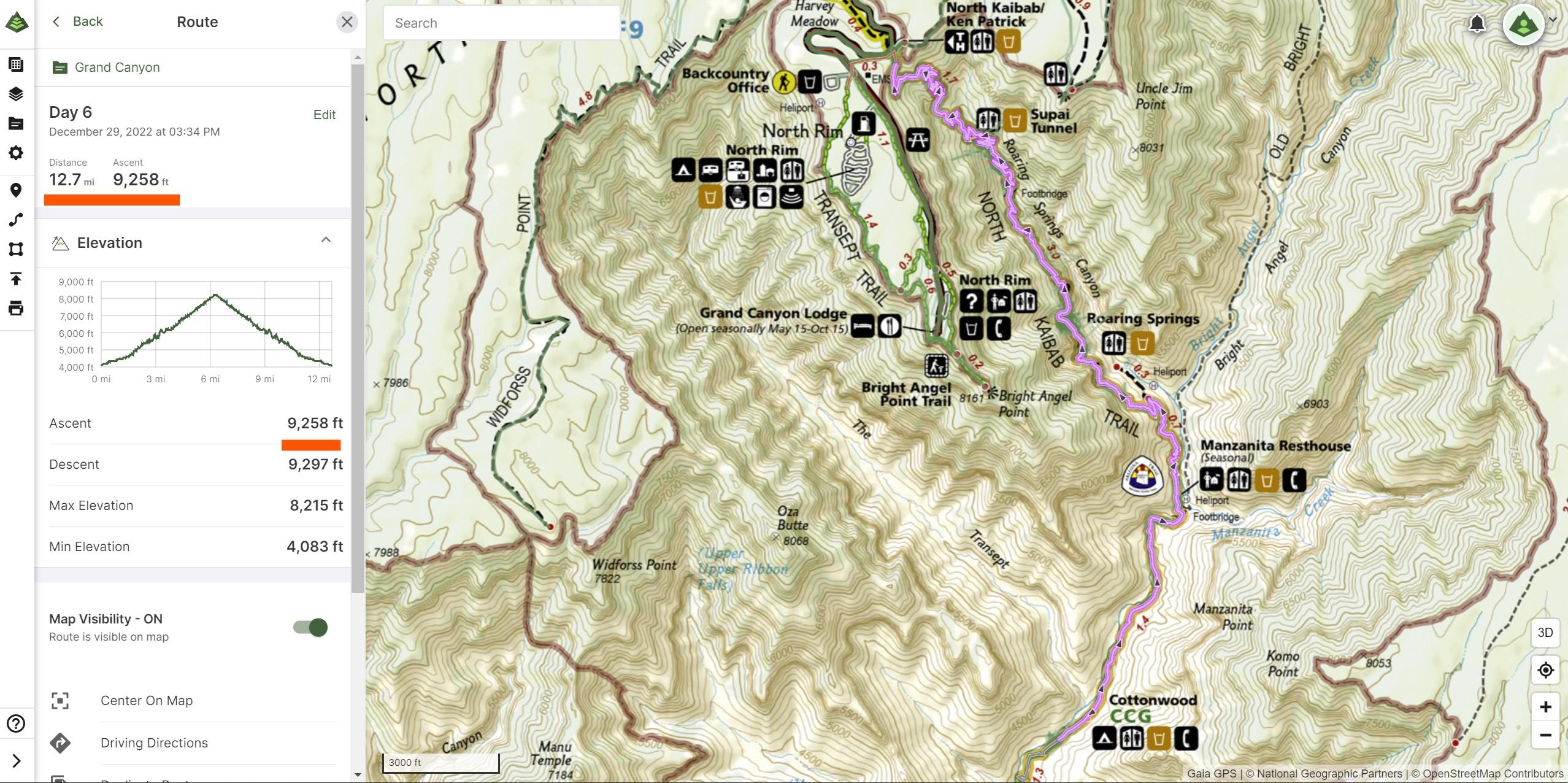
You can see by starting and stopping elevation the total ascent cannot be correct as listed.
Route as planned in GAIA

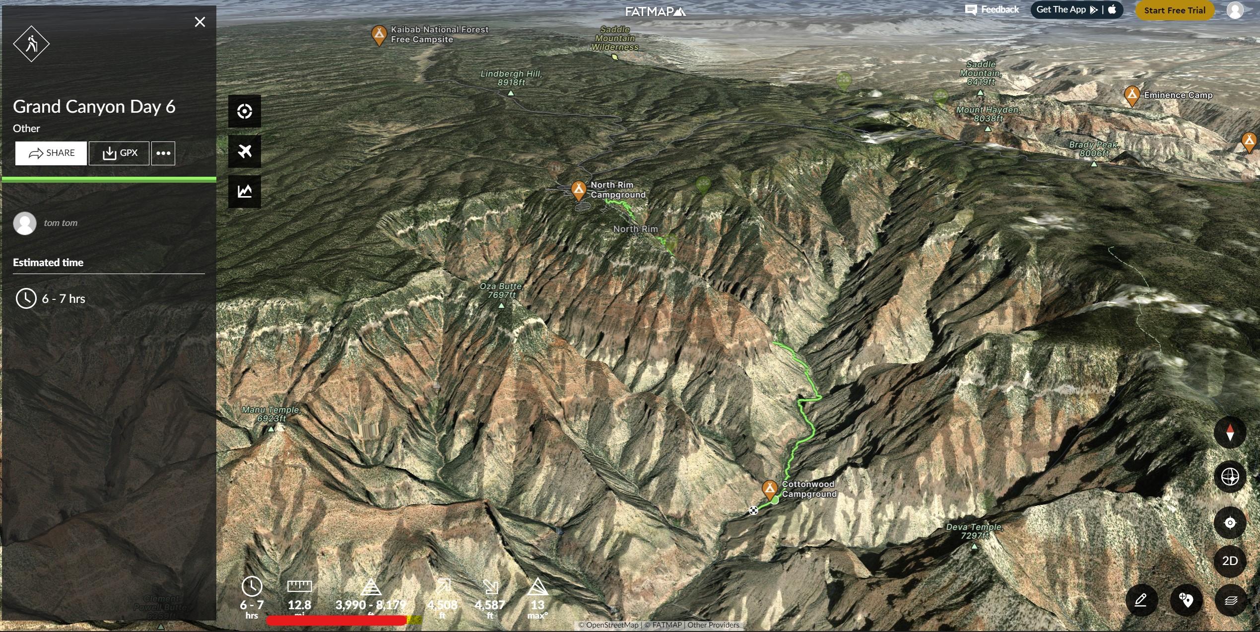
GPX file exported from GAIA and imported to Fatmap

I have reached out to GAIA GPS support and they have no advice other than to “clear cache” and re-install the app. I have done both and it changes nothing. I could ditch GAIA but I really like the NATGEO map layers for national park camp site and it seems like I cannot be the only one with this problem.
Any advice is greatly appreciate.
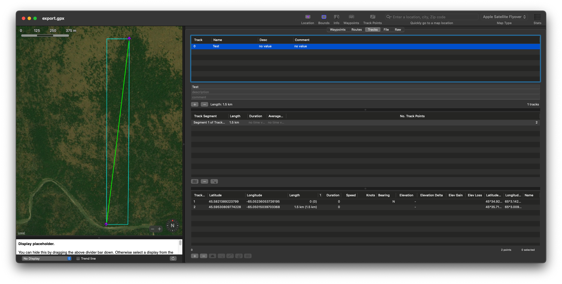
Here is the GPX file.
Jan 18, 2023 at 3:52 pm #3770666looking at the elevation profile on your first picture, I can see you start at 4200 or so, and goes up to about 8300 – 4100 feet elevation gain
I can see lots of little ups and downs. I wonder if that adds up to the extra 5000 feet?
Not that that helps you. If those little ups and downs are just measurement error, the software should average it out, but not if there were real ups and downs.
I don’t look at that elevation gain number because of that, but it’s usually just a small error. I just look at the max and min elevation and subtract. Add in other major, real ups and downs.
Maybe there was more elevation measurement error in your data for some reason.
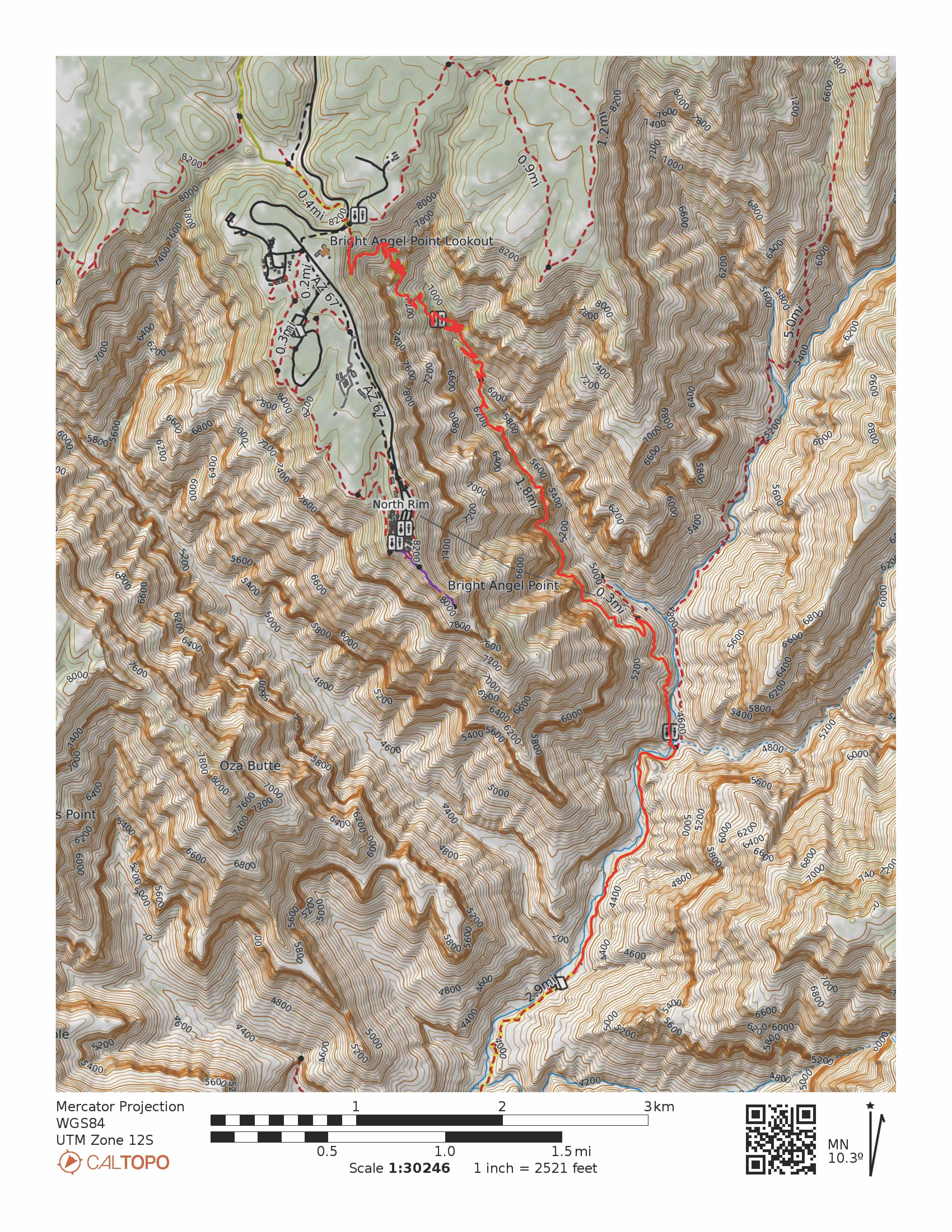
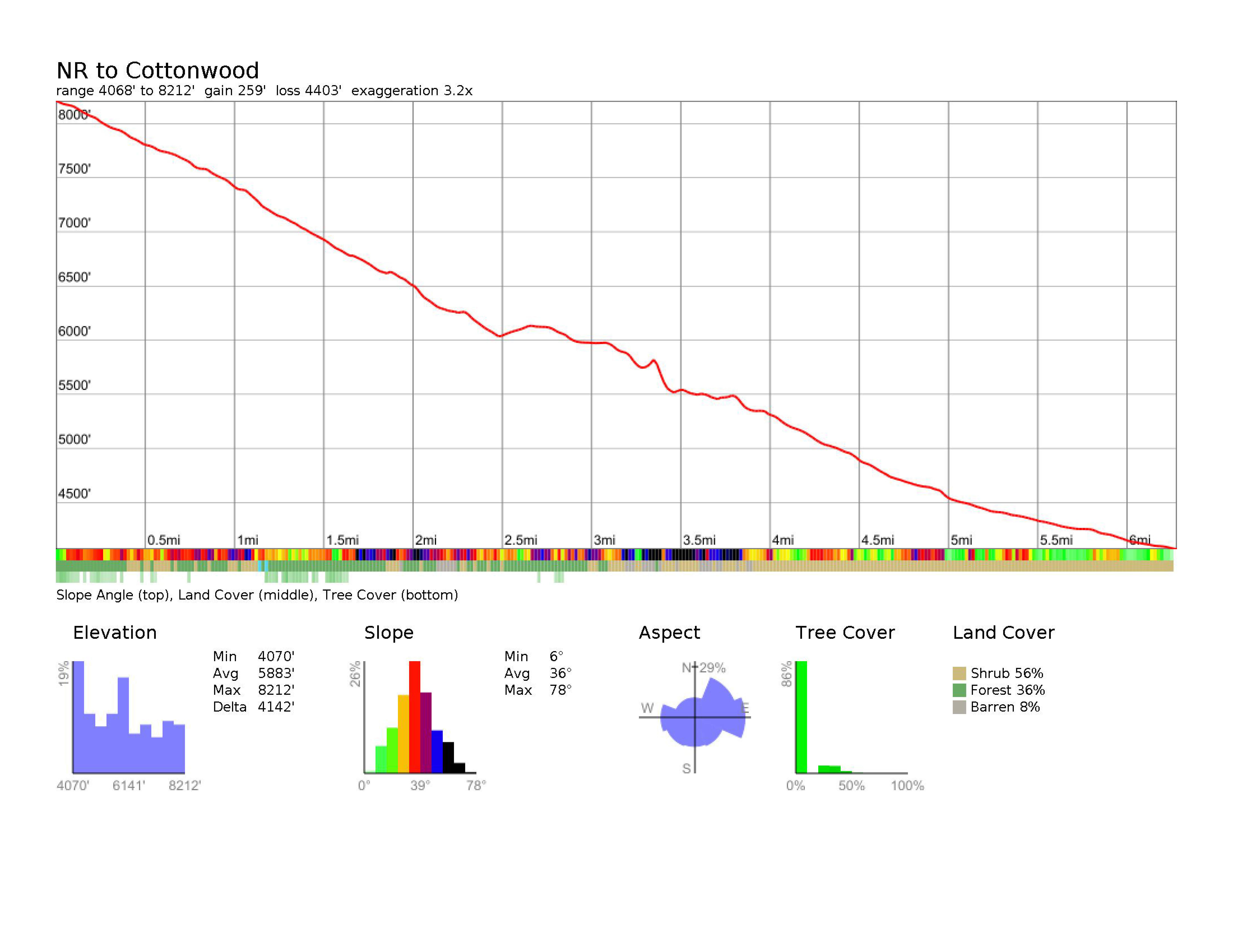
Jan 18, 2023 at 4:10 pm #3770670Caltopo has always served me much better than Gaia. Here is a track created by Caltopo of your route with its profile. Its quality speaks for itself.

 Jan 18, 2023 at 5:24 pm #3770674
+1 for Caltopo as well, I think they are best in the business.
Jan 18, 2023 at 6:19 pm #3770679Does elevation gain/loss show in GAIA when .gpx file is imported from Caltopo.
Surprised the master class makes no mention of this bug. It’s a 100% variance, makes calculations for energy miles impossible.
Jan 18, 2023 at 6:28 pm #3770682Interesting….my route is over 12 miles, the caltopo shows six if I am reading it correctly.
Jan 18, 2023 at 7:24 pm #3770732Looks like your Gaia is round trip. The CalTopo that Authur posted is one way, so double it and it matches.
Like Jerry pointed out, you can see the problem with the Gaia elevation profile. Instead of being a smooth line, like that trail would be for the most part, it shows a sawtooth pattern with a bunch of small ups and downs all the way through. This is probably what’s causing the problem. My guess would be that it has something to do with how it snaps to the trail. In that terrain, if it’s off just a little bit, it will cause a pretty big difference.
I’ve tried to like Gaia but always go back to CalTopo.
Jan 18, 2023 at 7:28 pm #3770735Yeah I can believe what you’re saying. I just am shocked that these up and downs lead to 100% more elevation gain or loss.
I’m also really surprised that I don’t see a lot of posts about it and Ryan is including it in the master class as a tool for trek planning. I’ll start playing around with Cal topo tomorrow and see if I can get the elevation to pass from caltopo over to Gaia. I’m a heavy user of Gaia based on national park layers from NatGeo
Jan 18, 2023 at 8:07 pm #3770749I have the exact same problem. Mileage in GAIA is spot-on but it grossly overstates elevation gain. I cannot figure out why.
Jan 18, 2023 at 10:14 pm #3770774lol…. I still count the contour lines :)))
Jan 19, 2023 at 2:08 am #3770775Mileage in GAIA is spot-on but it grossly overstates elevation gain. I cannot figure out why.
Solution offered from someone who uses neither – but who has spent a lifetime writing software.
Simply: software bug.Cheers
Jan 19, 2023 at 9:38 am #3770800I think this is a variation on the coastline problem: the higher the resolution you measure, the longer the length. Gaia is trying to measure too fine of detail. It is odd that they don’t appear to have that problem when measuring distance travelled. Their smoothing function must not be implemented properly for net elevation.
Jan 19, 2023 at 9:42 am #3770802Sounds right, I am surprised that it is this egregious (100% more than actual) and that it is not widely discussed. GAIA support doesn’t acknowledge the issue is this severe.
Jan 19, 2023 at 9:51 am #3770803I figured its a bug or something wrong with the algorithm. If I use the GAIA app on my phone to record a track, it’s pretty accurate. But if I use the computer to plan a route, elevation is wildly off…often by 1000+ feet for every 4000-5000 actual.
Jan 19, 2023 at 10:03 am #3770804That’s the impression I am getting as well. My only use for GAIA is as a planning tool for multi-day backcountry trips. Elevation information directly informs my planning of route and camping spots.
GAIA is even included as the preferred planning tool in the route planning master class. Anyone know how to @RyanJordan to see if he is aware?
Jan 19, 2023 at 10:20 am #3770807I’m fairly proficient with it…Searched high and low to see if it was something I’m doing wrong in my settings, but I can’t get beyond it. Maybe I’m still missing something quite simple?
Not great given I’m paying for this app. Everything else about it I like. But if this can’t get resolved I’ll likely move to another platform. Would also love to hear if Ryan is aware of this given he’s teaching it.
Maybe it’s a bug inherent in certain versions so not everyone sees it?
Jan 20, 2023 at 12:10 am #3770902Take a look at the thread Elevation Profile Sampling Intervals and the notes on gpsvisualizer.com that explain how sampling intervals and signal wandering affect the reported elevation gain of a track. Your issue is with a route, rather than a track, so it’s not signal wandering. But the way that your route waypoints hit the DEM may be giving you spurious ups and downs that increase the calculated net elevation gain. BTW, contour counting will usually underestimate the real net elevation gain, because it misses ups and downs that are smaller than the contour interval.
Jan 20, 2023 at 6:51 am #3770909Jan 20, 2023 at 6:44 pm #3770968Jan 20, 2023 at 7:02 pm #3770971I added a feature request to get elevation data included in the gpx export in Caltopo. I imagine the more people upvote it, the better the chance it will get implemented.
Add your vote: https://help.caltopo.com/hc/en-us/community/posts/12231482991771-Include-Elevation-Data-When-Exporting-a-GPX-File
Jan 20, 2023 at 7:51 pm #3770974Thanks Breau. I will vote that link! We might need a separate post for it.
Jan 21, 2023 at 8:37 am #3770994SDVanman, you may want to specifically ask Gaia support to forward/escalate your issue to the devs as a bug/something that needs to be addressed. Asking for that probably won’t get things sorted out quickly, but it could help for future trips. Support may also decline to escalate, but it can’t hurt.
Typically, the more people make a fuss and ask to get it escalated, the higher the odds something gets fixed.
Jan 21, 2023 at 1:09 pm #3771023“I added a feature request to get elevation data included in the gpx export in Caltopo. I imagine the more people upvote it, the better the chance it will get implemented.”
Why should a company who does is right, Caltopo, support a company that doesn’t do it right?
Jan 21, 2023 at 2:33 pm #3771031Elevation data isn’t just to import in Gaia. Lots of devices and software use gpx files.
Jan 24, 2023 at 10:09 am #3771286I have contacted GAIA support twice in an attempt to escalate with no response.
Appreciate the Caltopo suggestion as it seems to be MUCH more accurate regarding elevation change in plotting routes. I love the GAIA NatGeo map layers but this is a deal breaker for me, I will not be renewing my subscription.
I am really surprised that this elevation gain/loss data is functionally useless and that GAIA continues to be included in the master class series without a follow-up/update post from someone at BPL warning users of potential 100% inaccuracies.
-
AuthorPosts
- You must be logged in to reply to this topic.
Forum Posting
A Membership is required to post in the forums. Login or become a member to post in the member forums!
LAST CALL (Sale Ends Feb 24) - Hyperlite Mountain Gear's Biggest Sale of the Year.
All DCF shelters, packs, premium quilts, and accessories are on sale.
Our Community Posts are Moderated
Backpacking Light community posts are moderated and here to foster helpful and positive discussions about lightweight backpacking. Please be mindful of our values and boundaries and review our Community Guidelines prior to posting.
Get the Newsletter
Gear Research & Discovery Tools
- Browse our curated Gear Shop
- See the latest Gear Deals and Sales
- Our Recommendations
- Search for Gear on Sale with the Gear Finder
- Used Gear Swap
- Member Gear Reviews and BPL Gear Review Articles
- Browse by Gear Type or Brand.

