Topic
Campsites along JMT: Horseshoe Meadow to Onion Valley area
Forum Posting
A Membership is required to post in the forums. Login or become a member to post in the member forums!
Home › Forums › Campfire › Trip Planning › Campsites along JMT: Horseshoe Meadow to Onion Valley area
- This topic has 18 replies, 6 voices, and was last updated 7 years, 8 months ago by
 Anonymous.
-
AuthorPosts
-
Jun 15, 2017 at 4:33 pm #3473548
Any advice on the approach outlined below and potential camping areas along the JMT?
I am planning a thru hike from Horseshoe Meadow to Onion Valley in the Inyo National Forest with three other hikers. I’m attempting to break the trip into ~10-mile days for 5 days/4 nights. We will begin by taking the Cottonwood Lakes Trail to the New Army Pass to Soldier Lakes. After that, we head toward the PCT and take the PCT/JMT over Forester Pass, Kearsarge Pass and eventually turn toward Onion Valley. I am asking for input on places to camp along the way from those of you who have experience with this trail.
Here is what I have scoped out so far for places to stop for the night:
Night 1: Lower Soldier Lake
Night 2: Crabtree Meadow area (or Sandy Meadow since it should be less crowded there)
Night 3: Diamond Mesa. (Is this an advisable area to camp? I wanted to try and tackle Forester Pass with some fresh legs by staying in the Diamond Mesa area the night before.) Alternatively, I was thinking of staying at Tyndall Creek and doing a longer hike the next day for going up and over Forester Pass.
Night 4: Vidette Meadow/Vidette Creek area.
I am considering the idea of bringing a tarp/bug bivy to cut some weight so that may influence where we camp, e.g. need enough room for 4 campers + somewhat larger areas for pitching a tarp, etc.
Thanks for any help you can offer.
Michael
Jun 15, 2017 at 5:17 pm #3473557You don’t likely want to camp on Diamond Mesa. It’s off trail and exposed. I have camped just south of Diamond Mesa. That is a pleasant spot to camp for sure. ANd there is plenty of room there. We were maybe 1/4 mile off trail and just south of the mesa.
Vidette Meadows is fine camping. As I remember, there are bear boxes there.
There are plenty of good camp spots along the JMT with the exception of the passes.
Jun 15, 2017 at 5:41 pm #3473561 AnonymousInactive
+1 to Ben. Alternatively, you could push on from Crabtree/Sandy to the lakes just south of Forester Pass, and get the pass out of the way the next morning with fresh legs. It’s only a couple of easy miles longer than camping near Diamond Mesa, and would put you in great shape to camp at Kearsarge Lakes on your last night. They are, IMO, a better bet than anywhere in the vicinity of Vidette Meadows/Vidette Creek.
Jun 15, 2017 at 8:58 pm #3473595Thank you both.
I should have clarified that I meant the Diamond Mesa “area” not the mesa itself. the location I was eyeing was the two larger lakes on my Tom Harrison map on the eastside of the JMT trail, just south of Forester Pass; so, just northwest of the mesa. That sounds like what you’re describing, Tom. Or, maybe the lakes immediately south of Forester Pass?
And, if you have any familiarity with the rest of my path and have any inside tips, I’d appreciate it. I know this is a well traveled, busy segment so there is lots of information out there, but any tidbits, e.g. places NOT to stop at b/c they are simply too popular for camping, are more than welcome.
Michael
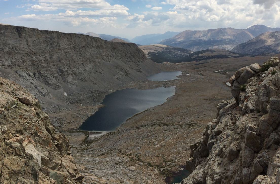
Jun 15, 2017 at 9:49 pm #3473600See below for a photo of the two lakes. There was more camping spots between the JMT Trail and the Lakes as opposed to alongside the lakes. Personally I think this area is a little more exposed than what I prefer, but it is completely doable. PM me an email address if you’d like to see the original photo file. The one below is lacking in detail due to this site’s file size limitations.
 Jun 15, 2017 at 10:26 pm #3473603
the area just south of Forester Pass is 12,000 ft elevation +- depending on where exactly you are talking about. so if you are not acclimated well, or have altitude issues …
the 3-4 miles south of Forester seemed very barren to the point of being otherworldly, at least to me. not that its a bad thing, just strange feeling.
Jun 16, 2017 at 6:44 am #3473626@kkkeating: Thank you for the offer; I sent a PM.
@asandh: We’ll be approaching from Crabtree/Sandy Meadow, ascending from about 10,700 feet to the lakes south of Forester. Taking our time and sleeping there should really be a benefit for getting over Forester the next day. From what I’ve read, this stretch is a bit “odd” compared to the remainder of the trail we’re hiking. That was part of my concern–a good place to camp without too much exposure, really. I believe we will be more exposed here than anywhere else we are going from Horseshoe Meadow to Onion Valley.Michael
Jun 16, 2017 at 8:31 am #3473646Here is my camp just at the south base of Diamond Mesa: https://goo.gl/photos/EnPUVX1LiwzpQuAZA
We took off from there off trail through Wright’s Lake Basin, which was really nice walking.
Jun 16, 2017 at 9:48 am #3473663AnonymousInactive“That sounds like what you’re describing, Tom. Or, maybe the lakes immediately south of Forester Pass?”
Either would do, but yes, that is what I was describing.
“And, if you have any familiarity with the rest of my path and have any inside tips, I’d appreciate it.”
Ben gave you an excellent suggestion for a very rewarding detour if you have time, only you would do it in reverse by heading up Wright Creek from where the JMT crosses it and then out via the low saddle on the ridge that leads from Mt Tyndall to Tawny Point before continuing on to Forester Pass. There is a faint trail on the east(right) side of the broad valley leading up to that saddle. It is important to pick it up, about halfway up the valley, to avoid some tedious scree/talus slogging to reach the saddle.
Another really nice detour would be up into Center Basin, once over Forester Pass. The hiking is easy and the views are magnificent up in the basin.
Each of these side trips would probably require an extra day, or longer hiking days, but would be well worth it if you can manage the time or extra effort.
Jun 16, 2017 at 7:56 pm #3473733You might get a copy of Elizabeth Wenk’s JMT book. She lists the campsites along the trail in the book. Excel and Google Earth/KMZ versions of those waypoints can be downloaded from the JMT Yahoo group. Then you can simple look at the trail in Google Earth and see where the camp spots are for detail planning.
Jun 17, 2017 at 8:23 am #3473763I wish I had more time to explore Center Basin and Wright Creek on this trip. We’ll be pressed for time, though. The Wenk book is excellent and I need to check it out of the library again. I seem to recall she did not have much information on campsites in the area just south of Forester, but it’s been a while since I looked at that specific information.
Thanks to everyone for chiming in. I’m getting very excited for the trip. I’m praying the roads we need opened will be opened (and repaired) in time for our trip!
Michael
Jun 17, 2017 at 12:52 pm #3473786AnonymousInactive“I’m praying the roads we need opened will be opened (and repaired) in time for our trip!”
Best of luck with your current itinerary. In the event the roads are not passable, do you have an alternate route scoped out? Might not be a bad idea in a year like this one.
Jun 17, 2017 at 4:54 pm #3473804Wenk notes a few “sandy” tent spots at two large lakes just south of Forester Pass. I’ll look into those further.
@ouzel Tom, yes; I’ve been giving it a lot of thought if the road to Horseshoe Meadows is closed. My options are to get a walk up permit for Kearsarge (which makes me feel uneasy since it is such a popular area), enter via Onion Valley and do an out and back or go over Forester and exit via Shepherds Pass. Another route would be to take Shepherds up to the JMT, over Forester and exit Onion Valley. The thought of doing Shepherds + Forester Pass in a single trip is daunting, though.
Michael
Jun 17, 2017 at 8:39 pm #3473816AnonymousInactive” enter via Onion Valley and do an out and back or go over Forester and exit via Shepherds Pass. Another route would be to take Shepherds up to the JMT, over Forester and exit Onion Valley. The thought of doing Shepherds + Forester Pass in a single trip is daunting, though”
Either option would be a fine trip. Of the two, though, I would suggest entering via Onion Valley and exiting via Shepherd Pass. The slog in over Shepherd Pass is very strenuous and gives you little time to acclimatize. Going in over Kearsarge and then the gradual hike up to Forester would be much more forgiving. It would also give you ample time for a side trip into Center Basin, as it is only a couple of easy miles off the JMT. Coming down Shepherd would give you a chance to evaluate it up close and see what is involved, in preparation for a later trip in that way. Difficulties aside, it is one of the most beautiful routes in the Sierra, and provides entry to some of the Sierra’s finest backpacking. The Upper Kern Basin, Wright Lakes Basin, Wallace Lakes Basin, and beyond to Great Western Divide country. Even if you don’t end up having to choose one of those routes this time, it would be well worth your while to consider them for future trips.
However things turn out, I hope you have a great trip!
Jun 17, 2017 at 10:03 pm #3473826Thanks for everything, Tom. Who knows…maybe we’ll end up crossing paths out there someday!
Michael
Jun 19, 2017 at 1:55 pm #3474075“Wenk notes a few “sandy” tent spots at two large lakes just south of Forester Pass.”
IIRC, literally just flat spots. Campable, but no ‘amenities’ like shade, rocks big enough to sit on, etc. It’s a relatively desolate area.
Jun 19, 2017 at 2:28 pm #3474079There is a small lake or 2 southwest of the point of Diamond Mesa there. They would be fine for camping, but a little boggy. That’s why we opted for the area a little further and straight south of Diamond Mesa.
Jun 19, 2017 at 6:12 pm #3474108AnonymousInactive“Thanks for everything, Tom. Who knows…maybe we’ll end up crossing paths out there someday!”
I’ll look forward to it. I’m easily recognizable as a wiry little guy in a pair of Montane Terra pants carrying a ULA Ohm. :0)
Jun 19, 2017 at 6:15 pm #3474110AnonymousInactive“That’s why we opted for the area a little further and straight south of Diamond Mesa.”
Just south of lake ~11,780? It looked that way from your picture. The brush indicating a seep from the lake was a dead giveaway. It’s a great area. For future reference, there are even better campsites on the NW end of that lake.
-
AuthorPosts

- You must be logged in to reply to this topic.
Forum Posting
A Membership is required to post in the forums. Login or become a member to post in the member forums!
LAST CALL (Sale Ends Feb 24) - Hyperlite Mountain Gear's Biggest Sale of the Year.
All DCF shelters, packs, premium quilts, and accessories are on sale.
Our Community Posts are Moderated
Backpacking Light community posts are moderated and here to foster helpful and positive discussions about lightweight backpacking. Please be mindful of our values and boundaries and review our Community Guidelines prior to posting.
Get the Newsletter
Gear Research & Discovery Tools
- Browse our curated Gear Shop
- See the latest Gear Deals and Sales
- Our Recommendations
- Search for Gear on Sale with the Gear Finder
- Used Gear Swap
- Member Gear Reviews and BPL Gear Review Articles
- Browse by Gear Type or Brand.
