Topic
Brooks Range – routes, river crossings, bugs
Forum Posting
A Membership is required to post in the forums. Login or become a member to post in the member forums!
Home › Forums › Campfire › Trip Planning › Brooks Range – routes, river crossings, bugs
- This topic has 11 replies, 4 voices, and was last updated 3 years, 8 months ago by
 Joe Hall.
-
AuthorPosts
-
Apr 14, 2019 at 2:16 pm #3588724
First post
Apr 14, 2019 at 2:17 pm #3588725I have a life goal to do some trekking in Alaska’s Brooks Range. A few questions for those who have been there…
- It looks like the easiest logistics are to go from the Dalton Highway (Wiseman or continental divide) to Anaktuvuk Pass. Are these routes doable in 8 days? Are there other routes people would recommend? For reference, in the Sierras I typically hike 12-14 miles/day on trail and 8-10 miles/day off trail.
- Which would be better in a typical year, June or July? I’m sure the mosquitoes will be bad in July so I would lean toward June if it can be done safely. A little snow travel is fine but I’d like to avoid extensive postholing or dangerous river crossings.
- I have a Klymit light weight packraft. Would this be worth bringing for river crossings, or would it typically be possible to cross without? I’m not looking to packraft long distances.
Thanks so much for the information!
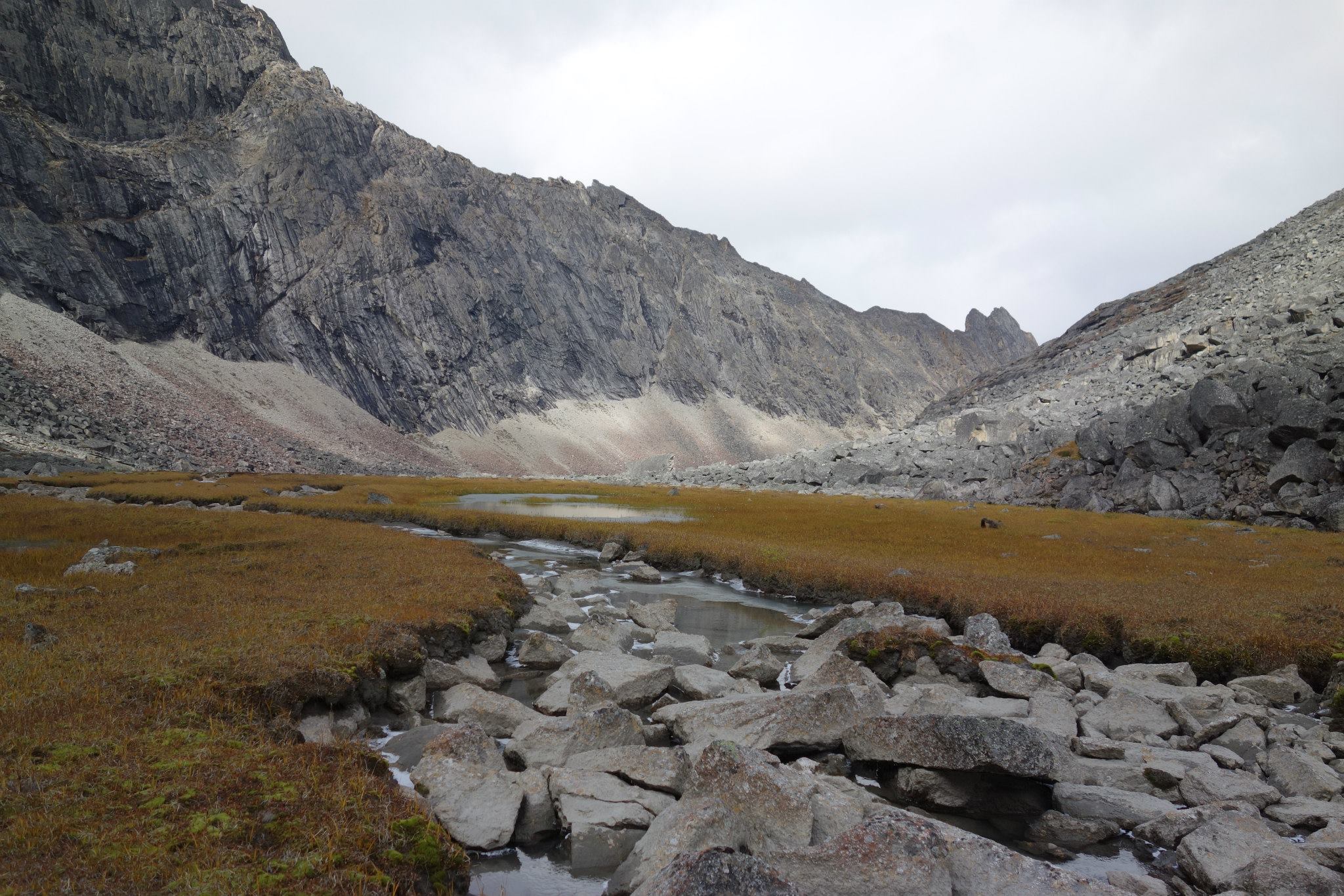
Apr 14, 2019 at 3:24 pm #3588734I haven’t done that route, but have done a trip in Brooks Range. Here are my thoughts: Terrain is really hard to judge on a topo map, what looks to be easy walking is often either full of ankle rolling tussocks, soggy muskeg, or worst of all thick brush (willow, alder, dwarf birch). Scraggly looking black spruce generally means boggy, if you see any white spruce in the distance, you can be pretty sure it is good walking as it prefers better drained soil. I went about 7-8 miles per day, which was about half my normal off trail pace and a third of my normal on trail pace. We often found sidehilling above the brush the fastest way to travel by foot.
Your feet will likely be wet most of the trip, so keep that in mind. I had no problem in breathable trail runners, but it’s something to be prepared for. Get good durable rain gear. It’s not supposed to rain a lot but we had rain and some snow. After it rains the brush gets wet and stays wet which can soak you just as fast as a rain. I took Golite Reed rainpants and though they survived with only a few holes and tears, they were really too fragile for the trip. When I went back to Alaska a couple years later (not in Brooks Range) I took a 3L Gore Tex Pant with a 30D shell. Also the DWR will be gone from whatever raingear you bring after a day of brush busting. If I were going back today, I might try the Colombia Outdry EX stuff that doesn’t require DWR.
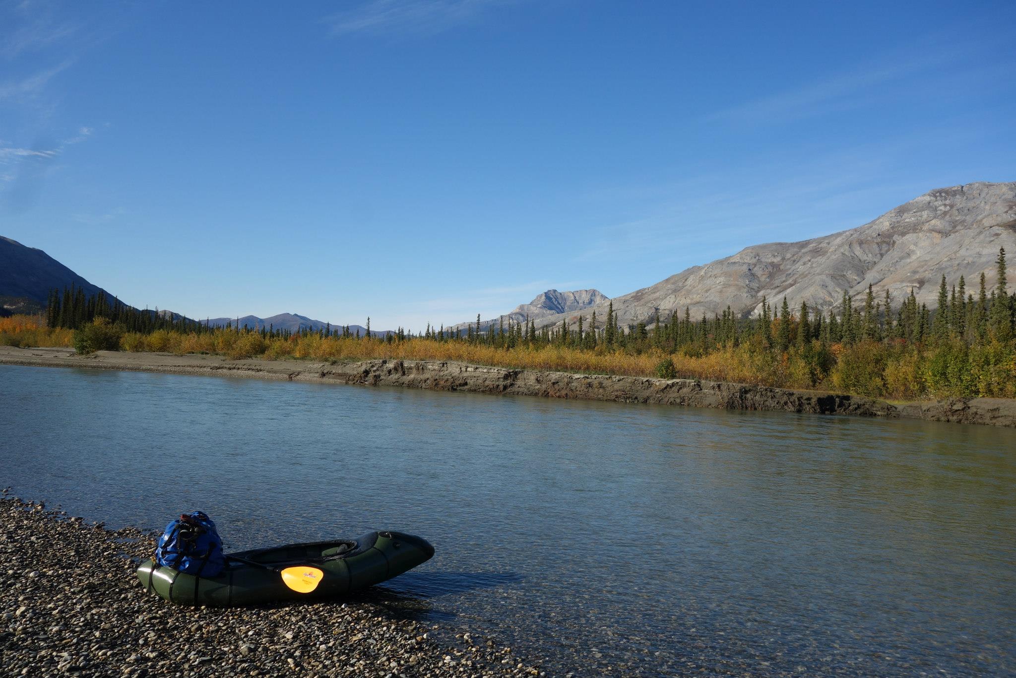
If you were interested in floating more, you could go from Anaktuvuk Pass to Wiseman and float a decent bit of it I think, which is by far the best way to travel in Alaska.
I would think snowmelt would have the rivers and creeks high in June, though perhaps not they don’t get tons of snow there. I went in August and had zero mosquitos. We saw lots of wolf tracks, moose tracks, and bear tracks, but only saw a couple of moose in person and a bear on the bush plane ride.
Here are a few pictures to get you excited


 Apr 14, 2019 at 3:42 pm #3588735
Lovely photos, Brad.
Apr 14, 2019 at 5:33 pm #3588749Brad – phenomenal pictures.
Anaktuvuk Pass to Wiseman with packraft looks like a great option. I’d be open to packrafting routes, but ideally nothing more than an easy class 2.
Apr 14, 2019 at 6:41 pm #3588761Here’s a summary of the piddly stuff I’ve done in the Brooks (served as a free Uber driver and hiked a day in and out:
https://backpackinglight.com/forums/topic/93549/
Here’s Manfred’s extensive write-up of the trip:
https://backpackinglight.com/forums/topic/94676/
If you don’t luck out with some total trail angel magic to get to the trailhead, A few thoughts:
It’s easier to hitch in Alaska than most places.
There are folks who offer free-lance non-Uber services on Craigslist (look under Fairbanks).
There are some Alaska ride-share groups on Facebook, but mostly I see Fairbanks-Anchorage requests and offerings.
There are $200 tours to at least the Arctic Circle on 12-15-passenger vans out of Fairbanks. They’ll charge you for the whole round trip. That gets you the first 198 miles, leaving another 70 miles to the visitor’s station in Wiseman. All the tourists and a few of us locals stop at the rest area with the Arctic Circle sign, so it’s a great place to chat people up to hitch the rest of the way.In the Sierra, well, almost anywhere, I caution against planning to catch fish to extend your food supply. The problem in some of the waters in the Brooks Range is the reverse – how to catch some reasonable-sized fish for dinner tonight and not some damn 20-pound fish that takes forever to land.
Just to get across a river, yes, I think a pretty minimal pack raft would be fine since you get to pick your spot (I may have the same Klymt raft – $99 from MassDrop?). The one I have actually paddles better with some weight (your pack) in the bow. With only the weight of my lower legs, there’s not enough of a ‘keel” to paddle a straight line – it then acts more like a round coracle / currach. I’m a big, big proponent of life jackets in small boats (having sunk a boat in the ocean one time) and have rigged up a CCF vest (not USCG-approved) that doubles as a sleeping pad (when you velcro the head and arm holes back in). But, again, you get to pick your crossing spots so maybe a PFD isn’t as important. I guess the risk is that you spend more time in the raft to fish and then the wind comes up or a bear walks by, etc. . .
Earlier is colder and that makes for fewer bugs but more runoff since a lot of snow is still melting. You’ll have a crazy, stupid amount of sunlight anytime in the summer, so consider an eye mask if that would help you sleep. And while of course you’ll bring a mosquito head net (and a broad-brimmed hat to keep the netting off your face), remember that you need bite-proof clothing for your whole body. I sometimes go a few years between using DEET just by keeping moving, but that’s easier on day hikes. It’s when I’m fishing by a stream or have stopped to make camp that they sometimes get bad. Make a few calls in advance to find out if the bugs are bad this year (there are broad, widely observed trends each year) and if they’re bad, have a plan for back of your hands – that’s always my weak spot if I haven’t brought some kind of gloves.
You didn’t ask, but: I definitely wouldn’t bring a gun for bear protection on that trip. I’d be on the fence about bear spray if in a group (noise from a group is better than anything else). On a solo trip, I’d lean towards bringing spray on that route, although I usually don’t carry it at home (I’ve trained the dog to alert me to critters, return quietly to me, and then we retreat).
Apr 14, 2019 at 7:26 pm #3588766Thanks for sharing your thoughts and suggestions, David.
In terms of transport, the Dalton Highway Express looks like a great option: http://www.daltonhighwayexpress.com/
Has anyone used this service?
Apr 14, 2019 at 7:38 pm #3588768That Dalton Highway Express looks like a very reasonably-priced option to get to the Visitor’s Center in Wiseman or the trailhead (but it shouldn’t be hard to hitch the last miles from the Visitor’s Center).
It’s an early start out of Fairbanks, but you get to Wiseman at a nice time – enough to get started and hike in a bit that day.
Apr 14, 2019 at 7:51 pm #3588770This trip report always looked like a cool jaunt. I don’t recall a map being provided, but I was able to easily recreate it in google earth using the place names provided.
May 15, 2021 at 5:54 am #3712632It seems like the most popular areas in the Gates of the Arctic are the Arrigetch Peaks and North Fork of the Koyukuk. Can anyone comment on the differences in scenery/difficulty between these locations for a hiking-only trip?
May 20, 2021 at 4:53 pm #3713742On my Brooks Range traverse I hiked from (just south of the divide) on the Haul Road to Anaktuvuk Pass in 7 days.
I’ve run across swarms of mosquitoes in the Arctic in June and July. Early June is likely to have fewer, but I’d expect to run into snow issues up high early in June. I was planning to do a Memorial Day hike off the Haul Road once in the foot hills on the south side of the Brooks Range and the snow was too deep.
What I did on that stretch on my traverse was stay close enough to the divide so I didn’t need a packraft. Plus there’s less brush up high. I’d cross drainages high enough that the water crossings were doable. It had been raining like crazy though and I still had one sketchy creek crossing in mid-July. Usually it wouldn’t have been a problem.
If my time window was June and July, I’d probably shoot for the last week in July for the best bet at a combination of low bugs, low water, and minimal snow.
May 20, 2021 at 9:39 pm #3713770I see this thread started a while ago. Are you going this summer?
Jun 1, 2021 at 6:51 pm #3716632We did a 6-day loop from Atigun Pass area a few years ago. Great walking with incredible scenery and wildlife. No flights required either. Happy to answer any questions
-
AuthorPosts
- You must be logged in to reply to this topic.
Forum Posting
A Membership is required to post in the forums. Login or become a member to post in the member forums!
Our Community Posts are Moderated
Backpacking Light community posts are moderated and here to foster helpful and positive discussions about lightweight backpacking. Please be mindful of our values and boundaries and review our Community Guidelines prior to posting.
Get the Newsletter
Gear Research & Discovery Tools
- Browse our curated Gear Shop
- See the latest Gear Deals and Sales
- Our Recommendations
- Search for Gear on Sale with the Gear Finder
- Used Gear Swap
- Member Gear Reviews and BPL Gear Review Articles
- Browse by Gear Type or Brand.


