Topic
Backpacking near major airports?
Forum Posting
A Membership is required to post in the forums. Login or become a member to post in the member forums!
Home › Forums › Campfire › Trip Planning › Backpacking near major airports?
- This topic is empty.
-
AuthorPosts
-
Jun 26, 2013 at 2:35 pm #1304653
It looks like I may get an extra long weekend in early August and am thinking about trying to fly in and do a quick trip. Since I am not going to have much time I was looking for somewhere without a long drive from the airport so I can maximize my time on the trail. What are my best choices for hiking near major airports (for cheap flights, maximum # of flight options)? Keep in mind I don't have permits anywhere at this time.
Jun 26, 2013 at 2:56 pm #2000040Chugach Mountains out of Anchorage. 10 mile walk across town. Or hitch, grab a cab or a city bus. Don't bother with a flashlight, you won't need it.
Jun 26, 2013 at 7:03 pm #2000109But extra long weekend, I assume you mean 4-5 days?
Denver has oodles of backpacking within a two hour drive or so of the airport.
Lots of options that way.
Denver is a major hub, so should be plenty of flights, too.
Jun 26, 2013 at 9:05 pm #2000143Denver has tons of non-stop flights from most major airports in the US at a reasonable cost. Lots of hiking options in RMNP. However, you have to drive through the People's Republic of Boulder to get there ;)
however, the Boulder Dushanbe Teahouse is pretty cool.
Jul 3, 2013 at 5:00 pm #2002262Thanks for everyones help, I have booked my flight to Denver and am planning to do a hike in Rocky Mountain National Park. I will be going and picking up the Trails Illustrated map and talking to the Backcountry office on Friday (if they are open). What areas should I look at? I will probably want to hike in 5-10 miles the first night and then do 10-15 miles per day for the next four days. I prefer to stay above tree line as much as possible as I just dont get those kinds of views in the eastern US.
Also, what temps should I prepare for in the high country? 75 for a high and 35 for a low?
Should I expect bugs the first week of August?
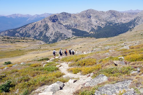
Jul 3, 2013 at 5:24 pm #2002270I have only been there once, so no help on trails. My methodology for new places is to get a detailed map and make up my own trip. There are lots of vistas. Here are some pictures from a trip 8 years ago with a $30 camera, just to up your excitement. Mags can probably provide more information and better pictures too.


 Jul 4, 2013 at 11:51 am #2002437
First, Nick..thanks for the nice words!
~50 +/- miles sounds like your intended goal?
So much to choose from.
There's this classic loop of course:
http://www.backpacker.com/destinations/hikes/399192 (closer to 50 according to most people) with some minor scrambling (class 3 perhaps), and IMO, easy route off-trail route finding. Get to do perhaps the most iconic 14er in CO (other than Pikes Peaks)View in the Snowbank Lakes area:

Your climbing won't be this technical ;) )

The loop above does hit the highlights, but I prefer the Mummy Ranger personally. Less people (relatively speaking; it is a national park :) ), very beautiful and just aesthetically pleasing.
Start at the Lawn Lake TH, work your way off trail to Mt. Chiquita (there is a use trail by Chimpmunk Lake heading up the ridge), then to Fairchild, drop to the Saddle, up to Rowe (or Hagues then Rowe if feeling ambitious) work your way to Stormy Peaks Trail down to north boundary trail to Cow Creek, west along Black Dark Mtn Tr to Lawn Lake and back. A LOT of cross country travel… Done this loop in different pieces over the years (including the cross country scrambling) as day hikes or backpacking loops. The off-trail scrambling will make up for your mileage goals. Obviously I did not lay this out as much as the Backpacker Mag loop above. You may want to print out appropriate 7.5 topos for the Mummy Range scrambling (class 2-3; easier than the Longs Peak approach above).
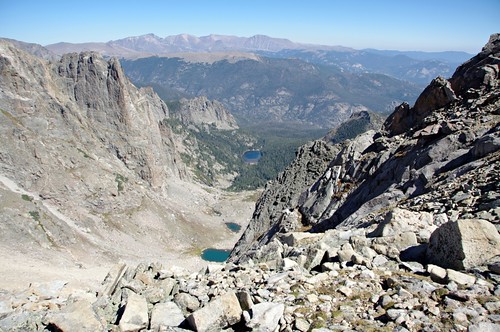
View for near Ypsilon:
Looking back to Ypsilon (notice the "Y" coliour)

Again, I love this range:
In fact, the best part of RMNP is off-trail IMO. The mountains are relatively gentle despite their height and have plenty of places for off-trail fun.
If you want to stick to on trail delights, may be a little more difficult in terms of mileage goals.
You could easily make a variation of this classic loop to add mileage:
http://www.pmags.com/backpacking-loops-%E2%80%93-mags-favorites#bear-lake-to-grand-lake-loopBut the views are rather lovely:

I liked it so much, I did this loop for my Bachelor party. :)
http://www.pmags.com/bachelor-party-on-foot-bear-lake-to-grand-lake-and-backNow, the weather in RMNP depends on the elevation, but generally speaking, I think high 60s/low 70s in the day and high 30s/low 40s at night is about right for the higher (10k+ ft) elevations in summer.
Finally, please be aware you do need a bear canister in most instances at RMNP now:
http://www.nps.gov/romo/planyourvisit/backcntry_guide.htmIf you have a cross-country campsite, not needed. (My buddy and I did not need one last summer when we did an overnight climb and bivied below Notch Top)
Other questions? Shoot them my way!
Jul 4, 2013 at 12:00 pm #2002439My vote would be Denver or Seattle. Denver with the explanation above, and I'm sure some Seattlites will chime in. Take the Metro? From Seattle to Farmers Market, pick up supplies, ferry to Olympic National park.
Jul 5, 2013 at 7:56 am #2002661Thank you for all your help. I am looking at the backpacker route and like the looks of it. I wonder if there will be any permits left this late. Here is what I was thinking:
Day 1 (~noon start) hike 7.9 miles over Flattop mountain to "Renegade Campsite"
Day 2 hike from Renegade to the road and Grand Lake and then up to Lake Verna to camp 14.1 miles
Day 3 hike from Lake Verna off trail over Boulder-Grand Pass and camp at Thunder Lake.
Day 4 hike off trail from Thunder Lake to the Hunters Creek camping area.
Day 5 hike from Hunters Creek to Longs Peak and back to trailhead.My question is how technical is the route to Longs Peak and the route from Hunters Creek to the Keyhole?
My only similar off trail experiance was in Wind River Range last year going from Titcomb Basin over Knapsack Col to Peak Lake. I believe it was rated as a class 3. I doubt that anyone is familiar with both that could compare the two.
I will check out the other routes when I get my map that I ordered (not avalible locally)
Jul 5, 2013 at 8:47 am #2002673Just noticed that you were in the Winds last year too about a month before me and went to a lot of the same places, green lakes, summit lake, lozier lakes, peak lake, vista pass, titcomb basin and most important of all knapsack col albeit from the other direction. How would you compare the two?
Jul 27, 2013 at 3:39 pm #2010055Everything is set for RMNP on Thursday this week, If the campsites are still available (they were when I talked to the backcountry office the other day) I will be going from Bear Lake over Flattop Mountain and into the North Inlet Watershead camping night 1 at Porcupine. Night 2 will be at either Slick Rock or Solitaire over in the East Inlet/Lake Verna area, the third night will be in the Hunters Creek Cross Country Area. We will then have to stay another night at Hunter Creek then tackle Longs Peak the last day or tackle Longs Peak day 4 and camp night 4 somewhere on the Bear Lake side (as of today there were spots at the Boulderfield and Goblins Forrest). Any other suggestions?
How are the bugs like now? I was planning to take a large shelter with no bug netting, but if the bugs are bad enough in the evening I can take my Spinnshelter and inner net.
The Tonahuto Drainage is closed for camping due to burn damage and as of now Alcohol and Esbit stoves are not allowed so I guess I will have to dust off the old Gigapower.
Jul 28, 2013 at 7:59 pm #2010404Skip the inner net. Bugs aren't bad this time of year at all. Have a great trip!
Jul 28, 2013 at 9:06 pm #2010426Sorry I did not reply earlier…just noticed the posts now.
They key hole route is somewhat harder than knapsack col IMO, but very well marked….and busy! :) plenty of people of all abilitY levels do this route.
Bugs should not be an issue, either.
Have a blast!
Jul 29, 2013 at 4:59 pm #2010705Thanks! I am looking forward to a great trip
Aug 6, 2013 at 8:30 am #2012907I just completed my trip in Rocky Mountain National Park and wanted to say thanks for all of the help. There were some flight delays and a long delay at Hertz car rental in Denver so due to our late arrival and wildfires this is what we ended up with:
Dunraven trailhead to Boundry Creek Campsite night 1. It was only 5.3 miles in but we didn't get to the trailhead until 5:30.
Day 2 was a really short day to Lost Lake (we were there by 10am but then went up to Lake Louise and Lake Dunraven and explored that area quite a bit.
Day 3 was all off trail going up over an unnammed pass between Mt Dunraven and Mt Dickerson. We summited Mt Dunraven (12,571ft) then skirted around Mummy Mountain and down to Lawn Lake. We saw a bull moose and an elk herd.
Day 4 we went up to the Saddle (12,398ft) and over to Crystal Lakes before heading down to Rabbit Ears campsite. We saw a bear and a huge bull elk.
Day 5 was a ho-hum day below treeline along the North Boundry Trail to complete the loop.
The weather was nice, warmer at night than I expected, about 45*, we got one hail storm with lightning where we hunkered down on Mummy Mountain but otherwise managed to avoid the daytime rain fairly well.
Aug 6, 2013 at 1:30 pm #2013002For those contemplating a future trip of this sort, I'd recommend looking at Aspen (connecting through Denver usually). You can land, get fuel and take the inexpensive bus to West Maroon trailhead within 2 hours. I was putzing around so I was on trail in 3 hours. No need for a rental car or lodging (depending on your flight times). Shower at Rec Center on your way out (can also rent a locker for non-trail items).
The caution, of course, is adjusting to altitude if you know you have issues. Trailhead is about 9400' and first camping opportunity is over 10K. I was going over 12,400' pass within 30 hours of leaving home at 600'.
-
AuthorPosts


- You must be logged in to reply to this topic.
Forum Posting
A Membership is required to post in the forums. Login or become a member to post in the member forums!
HAPPENING RIGHT NOW (February 11-21, 2025) - Shop Hyperlite Mountain Gear's Biggest Sale of the Year:

Our Community Posts are Moderated
Backpacking Light community posts are moderated and here to foster helpful and positive discussions about lightweight backpacking. Please be mindful of our values and boundaries and review our Community Guidelines prior to posting.
Get the Newsletter
Gear Research & Discovery Tools
- Browse our curated Gear Shop
- See the latest Gear Deals and Sales
- Our Recommendations
- Search for Gear on Sale with the Gear Finder
- Used Gear Swap
- Member Gear Reviews and BPL Gear Review Articles
- Browse by Gear Type or Brand.
