Topic
2017 Sawtooth trip – Info Needed
Forum Posting
A Membership is required to post in the forums. Login or become a member to post in the member forums!
Home › Forums › Campfire › Trip Planning › 2017 Sawtooth trip – Info Needed
- This topic has 15 replies, 5 voices, and was last updated 7 years, 6 months ago by
 Steve S.
-
AuthorPosts
-
Dec 19, 2016 at 7:30 pm #3441121
I’ve only been to the sawtooths once (First week of July in 2013) and it was a more leisurely trip. It was PERFECT conditions. no mosquitoes, great temps (highs between 50F and 65F) and enough clouds and weather to make for great pictures and some shade.
We went to goat lake and then camped at the lakes above hoping to summit Thompson peak but my brother became ill and we ended up hanging out at the lake and fishing. It was beautiful and relaxing but I’d like this trip to be a little more worth the drive.
The route I’m planning for 2017 is iron creek trailhead to goat lake, then thompson peak, then down into stephens lakes over to barron lakes, down to cramer lakes, then toxaway, alice and end at pettit lake. The plan is five to six days (we’re slower than many of you) and a good overview of the sawtooths with some off trail but not so much that I feel like we’re biting off more than we can chew.
1) Are there any changes or suggestions you’d make regarding that route?
2) Is the route doable in early to mid June? We would pack microspikes and trekking poles. Potentially we could bring ice axes and gaitors as well. I’m not really worried about weather or snow since we’ll plan for cold weather (down to 20F comfortably is what I’m shooting for).
3) Bugs. Honestly, I’m not nearly as concerned about snow free passes as I am the bugs. I have a fairly low tolerance for them. Obviously going late in the year is best for bug free but unfortunately getting time off for me in Aug and Sept is all but impossible.
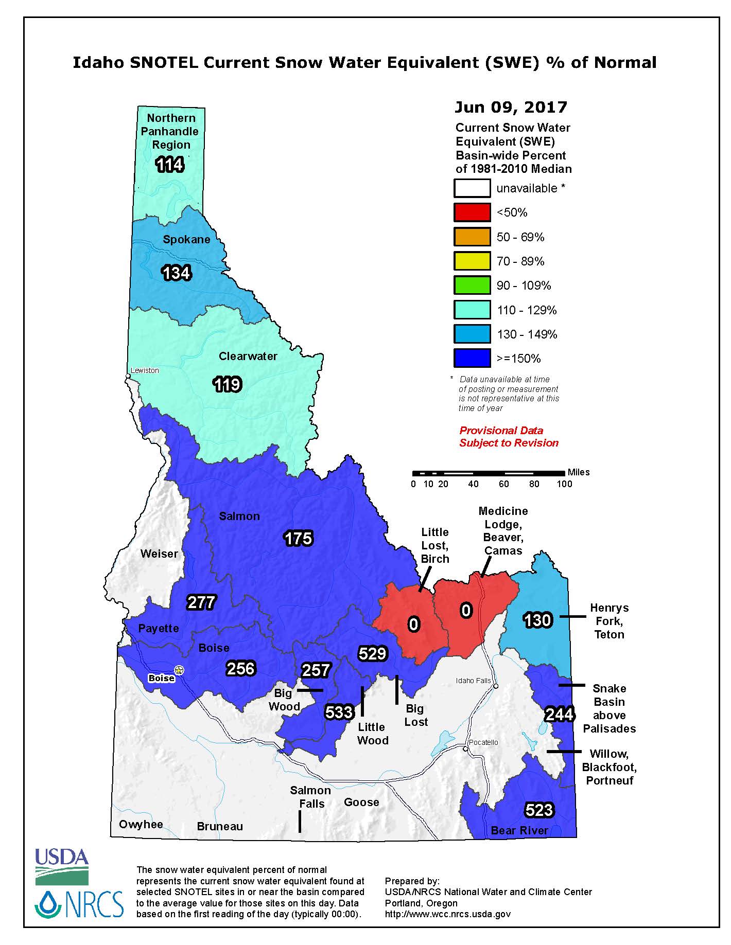
Thanks guys!Jan 25, 2017 at 3:46 pm #3447120Early to mid June will be mostly snow covered for sure. You are talking about some steep slopes with hard snow and possibly alpine ice at the time of year. They are all talus slopes. I have climbed most of the snow gullies etc around there, and I would have an axe in the car so that if conditions warrant, you won’t be caught lacking. That is for sure early season. If you stay up at snow line you will mitigate your bugs considerably. Again, look at the Stanley web cam. The route from Thompson will keep you on top of the mountain ridge above 10k all the way until dropping into the lake drainage. That might be your “crux”. But you get to bag a couple more peaks! There is a long lower angled ridge line that runs down right into the lakes. (above the “S” in Sawtooth that is printed on the topo map) This ridge line keeps you out of the steep stuff and puts you in the creek easily.
That sounds like enough time, and you can bail from Thompson and take the trail to catch back up to Kramer etc. with plenty of time.
Mar 13, 2017 at 5:56 am #3456291Are you going for the eclipse in August? Totality passes right over the Sawtooths
Mar 24, 2017 at 10:42 am #3459145Steve, thanks for the info. I’m going to keep a close watch on snow pack and weather over the next month or two. Snow pack is still fairly high right now even with the warm weather we’ve been having but all that could easily change. I think I’ll look at the last week in June or first week in July and if needed push it back a week.
Hitting Thompson and then down into the drainage is really the only part I’m worried about since there could potentially be quite a bit of snow.
I’m working on getting in shape for the trip, which is a big part of the equation for preparing. I’m sure I could slog it out right now with a lot of type 3 fun but I’d like it to be more enjoyable and less of a sufferfest.
Mar 24, 2017 at 10:46 am #3459148Dean, I would love to hit up the Sawtooths or Winds during August but August is the one month of the year where even a single vacation day off won’t be approved. September is difficult to take off as well, especially if it’s two of my coworkers and I taking time off at the same time. That leaves us late June, July and late Sept.
Mar 27, 2017 at 8:50 pm #3459901We have had a record or near record snowpack this season. I would plan my trip for the end of July.
Mar 27, 2017 at 9:05 pm #3459904 Mar 27, 2017 at 9:06 pm #3459905
It does look like the Sawtooths have had some decent snow this year so far. Our snow pack here in Utah was well over 200% in more places but has been dropping steadily. I’ll have to keep an eye on Idaho’s over the next few months as well.
Mar 28, 2017 at 8:35 am #3459968Even with all our snow, and it is a great year (I am a farmer) for water, the high peaks will still be very accessible by the 4th of July, and after it will go even quicker. I don’t see any real records in the snow pack, and it will follow the trend within the range where the snow pack is very typical with elevation and aspect. Bottom line is the high passes and some north facing areas will hold snow a tad bit longer than usual, but I don’t see any real changes in the season. If you wait two weeks, it will be back on track. Again, check the web cam. I can’t tell you how great it is to have that visual aid at your fingertips.
Mar 28, 2017 at 9:45 am #3459986I suspect that by late spring we’ll look back and this season will just be average. It’s just that the west was hit hard in Jan/Feb. It’s been a really mild March and unless something changes in April my guess is snow pack won’t be a big problem. Snow packs for Idaho and Utah have been dropping steadily for the past month.
Steve S I’m going to do as you suggest and follow the web cam and if you don’t mind I’ll ask for updates from your end since you seem to have a good handle on conditions.
I’m not afraid of some snow, we dealt with it on the passes in 2013 when I first went and it just made things a little more challenging and a lot more beautiful. Waist deep slushy postholing is another story but I just don’t see that happening. Like you said, the only snow we encountered was on the north facing slopes and only at high elevations. I’d love a repeat of those perfect conditions this go around.
May 30, 2017 at 5:25 pm #3470557We’re doing the grand loop starting at Grandjean on July 10th. Maybe we’ll end up seeing you on the trail
Jun 9, 2017 at 4:56 pm #3472542Jun 23, 2017 at 12:51 pm #3475032Hey guys, thought I would quickly and briefly chime in on what I know and what I don’t know about this season and the upcoming trips…
What I do know; omg there is still a TON of snow up there! I spoke with a hiking partner the other day who was up in Stanley over the weekend. He said snow was still at valley level in shady spots, and that meadows were total ponds and small lakes. Snow level extended far into the tree line and the rivers were quite high. Wow, well, a lot of that we could have seen from the web cam. But first hand knowledge is good stuff!
What I do not know; I farm, so I watch water. Its my livelihood. Down at the bottom end of the melt is where I am. What I see is our main rivers still at flood stage since March. We have not had any warm weather to speak of. The melt is SLOW so far. And yet we are still flooding! What does this mean for hiking? Damn, I’m kinda stumped.
But I typically base my decisions on that webcam. Right now, there isn’t really any hiking in the high country. I have doubts that even by the 4th of July it will passable to much of the range.
My advice; watch the web cam, call the Stanley Ranger Station, and maybe check with Kevin who lives in Sun Valley area for some more first hand reports. Earlier he was joking to me that no one was hiking until August! Hope that isn’t the case. So good luck guys, and here’s hoping it all works out!
Jul 5, 2017 at 10:40 pm #3477216Well, just got a text from a buddy of mine who hiked into the Hell Roaring Lake area. He told me snow above 8,000 ft, and bugs were thick if no breeze…
Not much else…… the web cam shows much more melting, and in the valley we have had triple digits for over a week and more on the way. All the high passes will be snow slogs for possibly quite a ways. Anyone over by Grandjean should be aware that the Payette crossing can be very adventuresome! And the same could be said at Flat Rock Jct…
So the high high country, well, still a LOT of snow…….. maybe some others who have actually hiked this past holiday weekend could chime in?
Jul 16, 2017 at 4:15 pm #3479254Ok, thought I would once again give you some info as my buddy just got back from Sawtooth lake and said it was still about 70% iced over! wow, hanging on for sure!
Lots of snow still. Will wait to hear how the early season adventures pan out. Looking like its going to be a stellar late season!
Jul 29, 2017 at 5:13 pm #3481760Hey, I was really interested in what people are referring to as the Grand Loop? We have a route called that but only a few locals know of it, and its almost entirely off trail……
what route are you describing?
-
AuthorPosts

- You must be logged in to reply to this topic.
Forum Posting
A Membership is required to post in the forums. Login or become a member to post in the member forums!
LAST CALL (Sale Ends Feb 24) - Hyperlite Mountain Gear's Biggest Sale of the Year.
All DCF shelters, packs, premium quilts, and accessories are on sale.
Our Community Posts are Moderated
Backpacking Light community posts are moderated and here to foster helpful and positive discussions about lightweight backpacking. Please be mindful of our values and boundaries and review our Community Guidelines prior to posting.
Get the Newsletter
Gear Research & Discovery Tools
- Browse our curated Gear Shop
- See the latest Gear Deals and Sales
- Our Recommendations
- Search for Gear on Sale with the Gear Finder
- Used Gear Swap
- Member Gear Reviews and BPL Gear Review Articles
- Browse by Gear Type or Brand.
