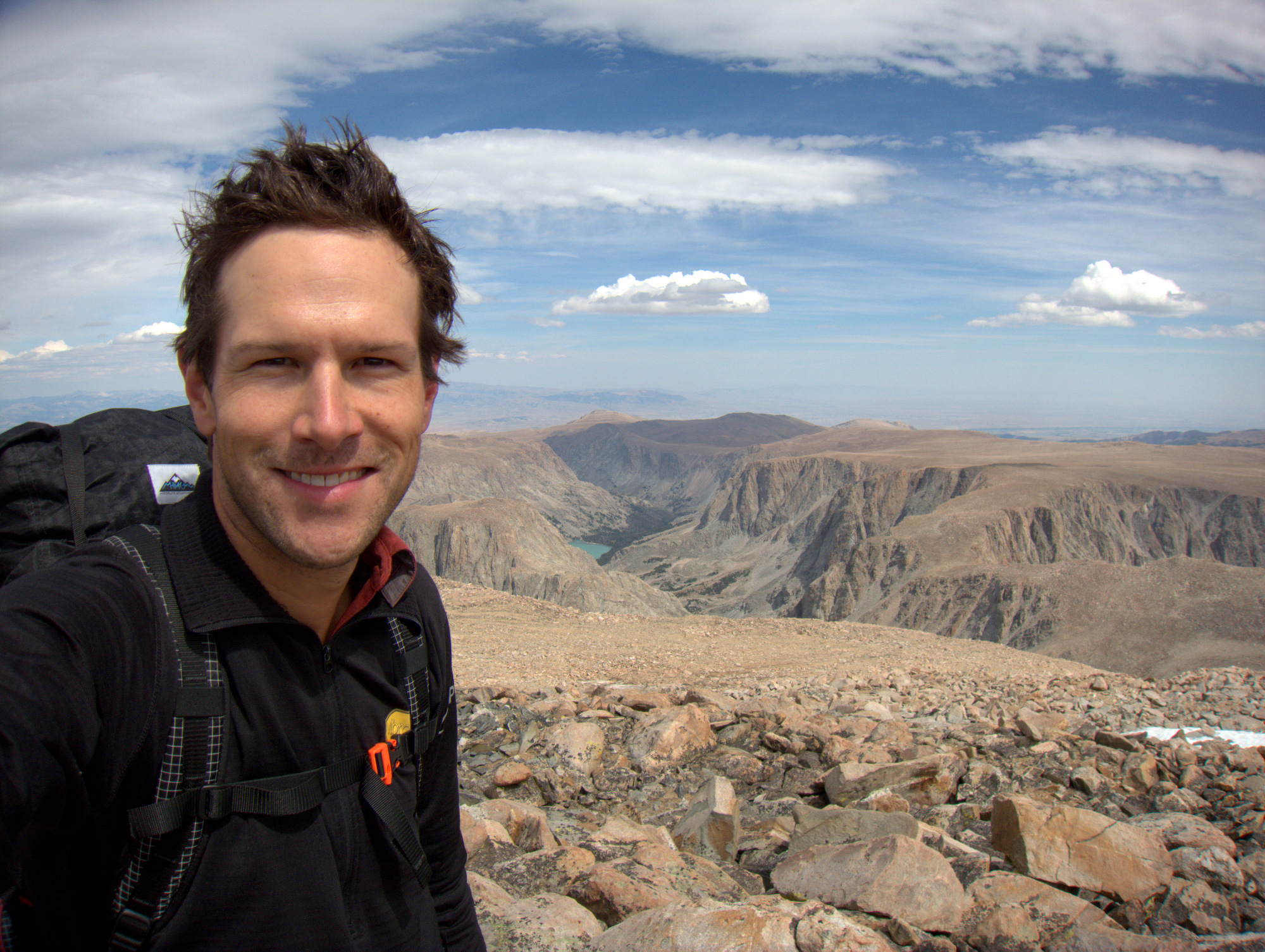

Wind River High Route: 100 Miles, 60k of Elevation
A “high route” is generally defined as an off-trail, above-the-treeline trek that traverses a range of peaks. And this summer, Andrew Skurka completed a doozy of a high route in Wyoming’s Wind River range.
This is a particularly interesting story for me because high routes are my own passion when it comes to wilderness travel styles, and I’ve completed a handful of high routes of varying lengths in the Winds.
Lots of attention has been given to “high routes” through the years – and for good reason: they take you above the treeline (so they’re scenic), they take you off trail (so they’re remote and offer solitude), and ‘there’s no markers, blazes, or signs (so they offer navigational challenges).
Some of the classic high routes, of course, include Roper’s (High Sierra, CA) and Petzoldt’s (Tetons, WY). You can now add, perhaps, Skurka’s (Wind Rivers, WY) to the list.
He recently pieced together a beautiful route that captures the essence of what a high route is all about. It is, of course, “yet another Wind River high route”. High routes have been “invented” in the Winds since the 1960s. But Skurka takes it to a new level, and his high route is the real deal.
He writes:
The world-class Wind River High Route is a 100-mile backpacking route through Wyoming’s Wind River Range. It is bookended with two 13,000-foot peaks, features 60 miles of off-trail travel, hovers usually between 10,000-12,000 feet, and never crosses a road. It is best completed as a continuous point-to-point thru-hike, but it can also be section-hiked via shorter loop routes.
Andrew hiked it in 4.5 days. That’s quite a clip for a hundred miles and 60k of vert through talus and tundra and passes and ridges, but us mere mortals should still be able to enjoy the route in a pair of joggers and carry a pretty light pack.
Read more at Andrew’s blog.

Discussion
Become a member to post in the forums.
Companion forum thread to: Skurka Pieces Together an Authentic Wind River High Route
A “high route” is generally defined as an off-trail, above-the-treeline trek that traverses a range of peaks. And this summer, Andrew Skurka completed a doozy of a high route in Wyoming’s Wind River range – 100 miles and 60,000 feet of elevation gain.
I’m devastated to learn that the Wind Rivers High Route route I did this summer lacked ‘authenticity’ :-(
I love WRR and will be going back next summer to do a loop including 5 alpine passes and crosses the continental divide 4 times.
While it’s great that you link to Andrew Skurka’s blog detailing his experience, I don’t see much detail describing the route itself. Is he holding that information back so that he can publish a commercial guide? My guess would be, “yes” based on the other route guides he’s selling on his site.
Fortunately, there are other sources of information describing the high route, including map sets and waypoints, which can be found for free. It would be nice if the original article would have linked to some of these resources to aid the aspiring trekker looking to tackle the route.
“Fortunately, there are other sources of information describing the high route, including map sets and waypoints, which can be found for free. It would be nice if the original article would have linked to some of these resources to aid the aspiring trekker looking to tackle the route.”
I would say, unfortunately all that info is available. Takes away the adventure of exploring it yourself. But I guess it is fortunate for those of you who think a ‘wilderness’ experience is following someone else’s way points.
I for one wish these self-styled ‘explorers’ would stop reporting in so much detail. Too much info actually destroys the wilderness experience… and eventually the actual wilderness
billy
I wonder how Nancy Pallister feels about all of these claims of new “High Routes” in the Winds. She wrote the book (probably the finest non-technical backcountry guidebook ever written). To each his own, but if you blast through 100 miles in the winds in 4.5 days, you’re missing a bunch of stuff. Really really cool stuff. Then again, I’m stricken with a disease called “fishing”, of which there is no better high country than the Winds. I’m sure he knows that and was blasting hard to set the bar high for future whispy-legged gazelles to eventually run the whole dang thing. Not my tip but I truly do mean to each his own.
Some interesting comments in here. Let me offer some thoughts.
@ Ed Hyatt. I’m assuming you followed one of the other proposed high routes and I bet you had a great trip. Hopefully you get a chance to return, though, since the northeast quadrant of the range — from Dinwoody Creek to Trail Lakes — is even one notch better. If you’re ever interested, there’s a loop out of Trail Lakes that covers most of it, and wouldn’t be redundant with what you’ve already done. Hike to Dinwoody Glacier via Glacier Trail, then cut north parallel to or atop the Divide to Downs Mountain, then descend via Goat Flat or Torrey Creek. I’m simplifying it, but that’s the route.
@ Jeff McWilliams. Indeed, I intend to publish the full details of the route as a guide. Given the hundreds of hours that go into developing a high-quality resource, I would hope that you can understand the need to charge a small amount for it. I don’t expect others to work for free, and don’t see why that is sometimes what seems to be expected of me. As with the Kings Canyon High Basin Route, I will supply enough free information that the route can be done without my guide, if you care to save yourself $25. Or you can save yourself a lot of time so that you can spend more time hiking and less time planning to hike.
@ Billy Ray. I wonder if you actually experience the wilderness of which you speak, because my experience when on these off-trail routes (even “popular” ones like the Sierra High Route) is that I see almost no one and see minimal evidence of others. I don’t feel that my “wilderness experience” has been adversely affected by the distribution of such information — and, if it were, there are hundreds of other worthy destinations to explore. Backcountry statistics support my observations: Kings Canyon, for example, issues fewer backcountry permits now than they did in the 1970’s (despite the country’s population being significantly less), and traffic is increasingly concentrated on corridors like the JMT, PCT, and Rim to Rim.
@ Sean Neves. First, don’t we all stand on the shoulders of giants? I am grateful to Pallister and Kelsey for the work that they did. Second, RJ’s post omitted a few details about my trip that might change your perspective. After reaching Trail Lakes in 4.25 days, I turned around yo-yo’d back to my car at Bruce Bridge on an entirely different route, which took another 3.75 days and which added 100 miles to my itinerary. 200 miles in the Winds (with 110 miles off-trail) in 8 days, at a pace that never exceeded 3 mph — I think I saw (not missed) a lot. Also, consider that the trip was partly a training effort for Run Rabbit Run, a 100-mile running race in Steamboat in mid-September. I placed third in 20+ hours. HYOH.
@ Andrew: you wrote: “@ Billy Ray. I wonder if you actually experience the wilderness of which you speak, because my experience when on these off-trail routes (even “popular” ones like the Sierra High Route) is that I see almost no one and see minimal evidence of others.”
By your own words the Sierra High Route has become POPULAR. That, by definition, is NOT wilderness. But prior to it becoming POPULAR it was wilderness. I have hiked parts of the SHR since before Roper put it in his book and I have hiked some of the same areas recently and I can tell you that there are many sections now that have become a kind of ‘use track’ whereas decades ago there was no trace. But you are too young to understand this. You have to have been out there for many decades to see the change. And more people too. Where it use to be that I saw absolutely no one on the SHR, now I see several people a day in many sections of it. And it only gets worse over time. But self-proclaimed ‘adventurers’ like yourself don’t want to see this. I don’t know what motivates you to make yourself into a kind of a ‘scout’ for the rest of us… wanting to be helpful? wanting to boost your ego? wanting to make money? a bit of all these? In any event, your work makes it easier for people to go there. So more people go there. And more tracks are left, and use trail segments develop. And then even more people go. It really does impact the felling of ‘wilderness’ for those of us who remember how it used to be. Perhaps you will see what damage you are doing when you get older and revisit these areas decades later.
And you wrote: “I don’t feel that my “wilderness experience” has been adversely affected by the distribution of such information — and, if it were, there are hundreds of other worthy destinations to explore.”
This is the cop-out, a rationalization often used by people who guide people into the little used areas… along with, ‘If I don’t someone else will anyway.” These ‘hundreds of worthy destinations to which you refer will also be written about and eventually you and your ilk will have destroyed all the true wilderness. It is apparently only a matter of time. Will it all be destroyed in our life time? Probably not. But that’s the problem too… we are too short sighted in our timelines… too self-involved to think of the big/long picture.
Anyway, I suppose it is inevitable. And in a relative sense, I suppose people won’t know what they have lost as the change happens so gradually. Like you, they will not notice it. Still… sad to me and, Still… wish you wouldn’t do what you do.
billy
I don’t feel that my “wilderness experience” has been adversely affected by the distribution of such information — and, if it were, there are hundreds of other worthy destinations to explore.
Andrew, thanks for the reply. I say, heed not we chubby lazy fishermen of the world. Alas, I’m the one who always has whiskey on his person at 13k and my ultra days are probably well past over. You’re doing incredible stuff and I’m just jealous that I wasn’t smart enough to make it a career. I’m also fine with people guiding and writing books. In this day and age, there is more beta online that in any book.
I’ve been wandering the Winds for 30 years now. My first real survival experience was in the Winds: 12 years old, by myself, no flashlight, no extra food, marveling at the beautiful June sunset from the shoulder of Mt Bonneville after post-holing for four hours. (You can guess the rest). Love that place and look forward to exploring your route further, although piecemeal. I’m not sure I understand the whole High Route thing as some of the best stuff is well off the spine of that range. I can see the logic in, say, the Western Weminuche in the San Juans, where the spine is where all of the good stuff is (Grenadier, Needles etc) but the Winds have so many high country options.
@Andrew: I do understand. And that’s fine. I already own four books on the Winds: Pallister’s “Beyond Trails”, Joe Kelsey’s “Climbing and Hiking in the Wind River Mountains”, Ron Adkison’s “Hiking Wyoming’s Wind River Range”, and an old one titled, “Field Book The Wind River Range” by Bonney and Bonney. I’ve read the first two rather heavily in the areas I’ve had interest.
I also gladly upgraded to Caltopo’s new “Pro” subscription to support a guy who I think puts out an incredible product, and I had donated to his SAR team a year ago for similar reasons.
I’d be totally willing to pay a reasonable price for a route guide such as yours.
@Billy As a resident of Michigan, your ideology only works well for people who live locally and have lots of time to “explore for yourself”. I don’t have those luxuries. Vacation time is short, and so is my budget, (despite my efforts to financially support book authors and map makers). I’d like to maximize my exploration time if it’s all the same to you.
Guides that say, “take trail B, trail A is below tree line and boring for miles”, or Andrew’s report that Bonny Pass would be dangerous without traction are really useful time and life savers to me.
I doubt a WRHR guide is going to destroy the wilderness experience. Crowded trails, inconsiderate campers, and hikers who don’t practice LNT destroy the wilderness experience. NOLS has been leading groups into the Winds for years, and so have various horse packing guides. The crowds are going to stick to easy-access destinations like Big Sandy Lake or the Cirque. With no resupply options along the WRHR, I suspect only serious hikers/trekkers are going to be interested in trying it.
I don’t even consider myself in the “serious hiker” category…. yet.
Billy Ray, the logic of your post is that, once someone has been through an area, it’s forever lost its wilderness credentials. In that case, let’s open up the wilderness areas nationwide to strip mining, clear cutting and road building because the virginal experience of the wild is forever lost in any case. Oh woe, the world will never be as it was when Billy roamed the wilds in his youth!
I fail to understand how people seeing the wilderness ruins it for those who somehow feel they can claim dibs on the mountains. As we mature, we learn that other people have also had the kinds of wild experiences that we once felt were ours alone. This can be a welcoming realization or poison our memories. Personally, I’m happy that other people are experiencing these routes. Overcrowding is the least of our worries here. And no, I don’t find that running into other people when I’m hiking irretrievably ruins the experience.
Link in article gets you a 404 error.
“Wilderness” or “wildland” is a natural environment on Earth that has not been significantly modified by civilized human activity. It may also be defined as: “The most intact, undisturbed wild natural areas left on our planet—those last truly wild places that humans do not control and have not developed with roads, pipelines or other industrial infrastructure….. From Wikipedia
Popularity has nothing to do with it.
Become a member to post in the forums.