Topic
Pressing the help button: Drama on andromea
Forum Posting
A Membership is required to post in the forums. Login or become a member to post in the member forums!
Home › Forums › General Forums › General Lightweight Backpacking Discussion › Pressing the help button: Drama on andromea
- This topic is empty.
-
AuthorPosts
-
Nov 5, 2013 at 9:25 am #1309502
http://www.thejasperlocal.com/drama-on-andromea.html
Soon, the pair were getting desperate. They were high on the mountain, unable to ascend back over the cornice, and not only was daylight fading but the weather was turning ugly. At 7 p.m., with a storm brewing, Townsend said they made the difficult decision to call for help. They activated the Spot’s 9-1-1 signal and then, to conserve battery power, promptly turned the unit off.
As Townsend and Brown maintained an icy foothold at 11,000 feet, hoping their distress call might somehow materialize into an air-lift to safety, a rescue operation was indeed beginning to roll out. However, although the SOS had been broadcast, the data that local rescue personnel had to work with was critically incomplete. Because Townsend had shut off the Spot device, its GPS locator was inert. The only coordinates that rescue personnel had to work with were those sent when the climber pushed the All’s-Well button on the summit—and even those appeared compromised.“We had low confidence in the coordinates,” said Max Darrah, Parks Canada’s public safety specialist and the on-call rescue leader that night.
More at link
Nov 5, 2013 at 12:15 pm #2041458>"They activated the Spot’s 9-1-1 signal and then, to conserve battery power, promptly turned the unit off."
RTFM!
And, especially with a SPOT, practice with the OK button to see what works, when, where and how long it takes.
Nov 5, 2013 at 12:56 pm #2041471Unlike most of the stories you link us to, Eric, in this case I think the press of the button was 100% justified. They totally screwed up by turning the SPOT back off, and by not activating it when they began self-rescuing and moving again. But it sounds like they did a lot of things right, also.
The location accuracy issue is one of the reasons I use a PLB instead of a SPOT. There are enough anecdotes about SPOT failures that I'm leery of them (but believe they are better than nothing).
Nov 5, 2013 at 1:15 pm #2041475Dena –
"The location accuracy issue is one of the reasons I use a PLB instead of a SPOT. There are enough anecdotes about SPOT failures that I'm leery of them …"I understand failures in the on-the-ground infrastructure of SPOT, but have not of "accuracy issues" – at least where good procedure was followed.
Do you have any links to posts regarding "accuracy issues" with SPOT?
Thanks.
Nov 5, 2013 at 1:25 pm #2041479I think part of the problem is that too many users of GPS, Spot, PLB, Inreach, or any of the other high-tech satellite-based gadgets don't really understand how the thing works, or what actions they can take to make it better or make it fail.
–B.G.–
Nov 5, 2013 at 1:36 pm #2041485Bob,
In this case the location was off by 1.5 km. Perhaps as a result of echo/bounce/or?? And I assume that had they left the device on S&R would had gotten their correct location from another of the satellites overhead (doppler?)So I am curious how often this happens, and if it is more prevalent with SPOT versus other EPLBs. I would think that coordinate acquisition from the GPS constellation and the secondary satellite's "doppler" fix would be very similar, regardless of device.
Nov 5, 2013 at 2:31 pm #2041517>"Do you have any links to posts regarding "accuracy issues" with SPOT?"
Dena and I are maybe a little more particular about high-latitude performance than most of you (I'm at 60N, she's about 61N), but SPOT, using equatorial satellites last I checked, is weaker at acquiring a location than a PLB that also uses polar-orbitting satellites. I certainly have spotty SPOT performance even in my driveway, with no hills around, at 60N. It also does poorly, even with many attempts at sending an OK signals in canyons in the SW. Any unit will be challenged by use in a canyon, but polar satellites have a chance of seeing you in some locations that equatorial satellites never could.
I now use a PLB after using a SPOT for 3 years. Mostly for the reliability if I really need it, also to avoid the subscription fee, and because I didn't find a lot of value in the "OK" and "HELP" functions.
Nov 5, 2013 at 2:43 pm #2041519"In this case the location was off by 1.5 km. Perhaps as a result of echo/bounce/or?? And I assume that had they left the device on S&R would had gotten their correct location from another of the satellites overhead (doppler?)"
I don't think that we have all of the facts, and rushing to conclusions from a brief nontechnical news article is problematic.
I kind of got the impression from the story was that one fix was transmitted successfully down below. Then, when they got into trouble, they tried to send the SOS message. However, if the view of the sky was semi-blocked, the device could not get it fully sent. Sometimes those gadgets have to send the SOS repeatedly for a few minutes before it finally gets to the bird. Then, they almost need to keep it running. Most of the time, the device needs to send that SOS and then stay in roughly the same location until help arrives. As soon as the rescue dispatcher gets the initial call, they can continuously track the device. If they see that it is moving away at a normal speed, then they often abort the rescue. If the device is powered down, then they don't know what to think.
"So I am curious how often this happens, and if it is more prevalent with SPOT versus other EPLBs. I would think that coordinate acquisition from the GPS constellation and the secondary satellite's "doppler" fix would be very similar, regardless of device."
Well, again, the user needs to have a firm grasp on what satellites are doing what, and where they are in the sky, and where you might need to move to for improving the chance of the message getting out. That's the problem with a one-way message. The user never knows whether it got out intact. Now, if you are in an emergency and you are stuck in a wind storm up on the side of a mountain, you probably do not want to have to think about where satellites are in the sky. You probably can't even tell directions up there.
The other thing is a simple GPS weakness, and it can affect virtually all GPS receivers at some time or another. That is a GPS Blunder. It can spontaneously come up with a position fix for you that is totally bogus. It might show you as being a hundred miles away, traveling at 400 miles per hour, and you are at 25,000 feet elevation. This doesn't happen very often, and it happens less and less with some extra intelligence that some of the newest receivers often have. The human user sees a totally bogus fix, thinks about it for a few seconds, and then says, "That's B.S. That must be a GPS Blunder." So, the user shuts down the receiver, counts to ten, and then starts it back up. When the new fix comes up, it is unlikely to have the problem still showing. I think that Mil-Spec receivers have other features that can help eliminate the problem even more.
With two-way messages, the user can send an SOS and then wait. Ten minutes later the rescue dispatcher sends you something like, "What is the nature of your emergency?" Then when you send back, "Broke leg Can't walk Need help" the rescue dispatcher can make some good assumptions about what is really going on.
Last year, a person that I know had all of the standard symptoms of HAPE and HACE setting in when backpacking with a group at high elevation. Eventually, a stranger came by with a Spot device, and eventually the SOS call was sent. Then the stranger took his Spot device and left, once they _assumed_ that help would be on the way. Well, the dispatcher got the SOS coordinates, but then they saw the device's coordinates were moving away, so they _assumed_ that it was a false alarm. Eventually the person was rescued by helicopter, no thanks to the Spot call.
–B.G.–
Nov 5, 2013 at 2:54 pm #2041526I just had a thought. Maybe someday we'll get this in the design.
If your emergency device gets its GPS fix OK, then that is a start. If it doesn't get a good fix, then it needs to have the intelligence to tell the user what to do. "Turn 90 degrees to your right and take twenty steps, then try again." To do that, it would need a digital compass so that it knew which direction you were facing. "Do you see big reflective surfaces around or above you? Then get above or away from them and try again."
To do this, the device would have to have some basic idea of the terrain around you, or at least in the neighborhood of the last fix that it got.
–B.G.–
Nov 5, 2013 at 3:31 pm #2041529"However, although the SOS had been broadcast, the data that local rescue personnel had to work with was critically incomplete. Because Townsend had shut off the Spot device, its GPS locator was inert. The only coordinates that rescue personnel had to work with were those sent when the climber pushed the All’s-Well button on the summit—and even those appeared compromised."
I really need to tune up my critical reading/retention skills and stop looking at the pictures.
Arg.
On to getting a GPS fix –
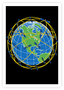
The GPS constellation consists of 32 satellites orbiting in a Shell around the earth, not parked in quatorial geosynchronous locations.
So why is it more difficult for SPOT users at 60°N to get a location fix versus someone at 40°N?
Nov 5, 2013 at 3:50 pm #2041536"The GPS constellation consists of 32 satellites orbiting in a Shell around the earth, not parked in quatorial geosynchronous locations."
Equatorial is the word. Normal communications satellites are geosynchronous or geostationary. That means that they are flying over the Equator at the same rate that the Earth turns, so that means that they appear to be in the same place in the sky virtually all of the time.
The complete contrast to this is a military spy satellite. They fly a polar orbit, and typically at a much lower altitude.
GPS satellites are in-between these two extremes. They fly an oblique polar orbit at half of the geostationary altitude. So, picture them this way. They fly up across the southwestern horizon, and then sometime later they disappear over the northeastern horizon. Then, on the other side of the Earth, they are appearing over the northwestern horizon and disappearing over the southeastern horizon. It ends up making a real mesh across the visible sky to _most_ places on Earth. Now, where GPS has weaknesses are at the extreme North and South poles. GPS will work there, but the satellites will all appear to be low in the sky. They tend to have some more problems and less accuracy, but GPS still works.
"So why is it more difficult for SPOT users at 60°N to get a location fix versus someone at 40°N?"
Spot users are trying to receive GPS signals, and the closer you get toward the North or South poles, the lower in the sky the satellites will be. If you have flat featureless terrain, then that will likely work, but if you are on the wrong side of the Brooks Range, it might be a real problem.
One time a customer of mine called and wanted to buy a very expensive GPS system from my employer, and he wanted me to go there to help him install it. I was all gung-ho, and then they told us where it was. It was the North Slope of Alaska (70 degrees North) in the middle of winter. Once we realized the potential problems and how long it might take to get things aligned right, we offered him a better deal for him to fly to San Jose California and we would give him a free class on how to do it.
–B.G.–
Nov 5, 2013 at 4:08 pm #2041541Also, SPOT uses the lower orbital satellite system called the Globalstar network. PLB's use the higher orbital SARSAT network. Globalstar is fine in lower latitudes but at the higher latitudes it's so low on the horizon that it can be out of view in a valley, or at very high latitudes can be unreachable entirely. There's all kinds of reports of people with SPOTS and Globalstar Satellite phones that have experienced failures in Alaska and other high latitude positions around the world. SARSAT, with it's higher orbit, is more reliable for us in the higher latitudes.
Nov 5, 2013 at 4:08 pm #2041542Bob –
"Now, where GPS has weaknesses are at the extreme North and South poles. GPS will work there, but the satellites will all appear to be low in the sky.""The orbital period is one-half a sidereal day, i.e., 11 hours and 58 minutes so that the satellites pass over the same locations[59] or almost the same locations[60] every day. The orbits are arranged so that at least six satellites are always within line of sight from almost everywhere on Earth's surface."

Is "Almost" the key word here?
Nov 5, 2013 at 4:11 pm #2041543In contrast to this entire discussion about how to summon help to a wilderness area, would you care to guess the worst place to try to do this? By that, I mean the worst place to try to activate a Spot or get a good GPS fix.
If you were aligned with the GPS satellite tracks (oblique), you would likely get the best, and if you were in flat terrain, that would help a lot.
Where it is the worst is in downtown New York City. The streets and avenues are aligned just about counter to the GPS satellite tracks, and the skyscraper buildings make the limited view of any sky problematic for more than a few seconds at a time. I was putting in a big GPS system there one time, and it was a huge problem. I had to put up two independent antenna arrays, and one would be looking down Park Avenue and the other would be looking down Lexington. Then the system would switch back and forth between the two. Buildings were 55 stories tall, all steel and glass, with huge reflective surfaces to make multipath interference. Signals getting all the way to the ground were brief. Some GPS systems can be "told" what to expect from this, and they can operate OK. So, think about that on the next time you are out in the wilderness and you complain about satellite signals.
–B.G.–
Nov 5, 2013 at 4:17 pm #2041545"Is "Almost" the key word here?"
YES.
One small detail is that every once in a while, a GPS satellite gets a little funky in performance. So, it will be temporarily taken offline and another satellite will fill in. So, sometimes there are temporary _holes_ in the mesh pattern. They don't completely foul things up, but they contribute to accuracy errors.
The opposite was one time I had summited on the tallest peak of the Southern Hemisphere, so there was no sky obstruction anywhere at all. I let the receiver run, and it acquired a whole bunch of GPS signals. The vertical elevation calculation was only one meter off the surveyed elevation, so the horizontal calculation was even better. You can't get much better than that.
–B.G.–
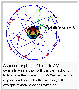
Nov 5, 2013 at 4:26 pm #2041551"Here is the gif."
If you watch that animation, you will see how many GPS satellites are typically in view, assuming good conditions on the ground. Now you know why 8-channel and 12-channel receivers became so popular 15 years ago, in contrast to the earlier receivers that could not look for as many satellites.
However, there is likely to be some stupid user who is pounding his GPS receiver onto a rock claiming that it has failed because it doesn't see nearly all 32 birds at once.
–B.G.–
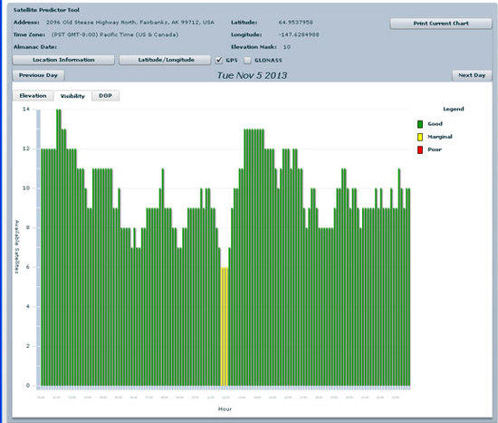
Nov 5, 2013 at 4:38 pm #2041557
A difficult screen capture, but it's for Fairbanks. On the vertical axis is the number of GPS satellites "available", and along the horizontal axis the Hour of the Day. So most of the time, 6 or more are there, and often there are 8 or more.
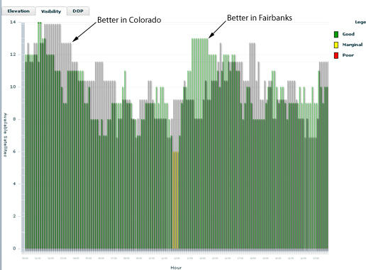
And this is what things look like at 38°N, my neck of the woods –

– not that different.Edit: Compliments of NavComTech
Nov 5, 2013 at 5:01 pm #2041564Six or eight or ten or twelve satellites. OK. And those charts are for a mask angle of 10 degrees. That means that we are ignoring any satellites below 10 degrees. If you take one beautiful maple tree and stick it up 20 degrees from the horizon, you see that you can get in trouble in a hurry. One or two birds might be lost at any point in time. Then where it really gets ugly is the picket fence problem. If a particular satellite is up in view for a long time, then that is fine. But, what if it goes behind one tree, then it is visible, then it goes behind another tree? Many receivers will simply not be able to use any satellite signals unless the signal is more constantly stable than that. The receiver has to stay locked onto one signal for it to be good. That is especially true in a cold fix situation, and not so much for a warm fix or hot fix situation.
–B.G.–
Nov 5, 2013 at 5:18 pm #2041570Greg, if you want a better view of the sky, roll up the road to Schriever AFB and look for the big spherical antenna. That's as good as it gets.
Now figure out how to cram that into your backpack…
—B.G.–
Nov 5, 2013 at 5:29 pm #2041574Bob,
Masking, fences, trees, etc are a problem, but when I look at Fairbanks versus 38°N I don't see enough of a difference to make a meadow in Alaska much worse than one in central Colorado.
It looks like equivalent coverage to me.
So is poor GPS coverage in Alaska just a "legacy myth"?
Nov 5, 2013 at 5:35 pm #2041575Sorry, I was sloppy in my wording. Of course GPS is GPS. But as Dena details, the outbound communication by SPOT and by PLBs are handled by different satellite networks. My SPOT often knows where it is. But it can't reach those low-angle communications satellites very reliably.
My understanding is that the ACR PLB:
http://www.rei.com/product/815753/acr-electronics-resqlink-406-gps-personal-locator-beacon
also pings the polar-orbitting constellation of Russian satellites. Which is good, because we can see Russia from our house. So that is what I carry. Looks like I'll be doing a road trip to the Arctic Ocean in January. I deactivated and PIF'ed my SPOT, but it would almost be fun to bring one and leave it on track mode on the Dalton Highway to see how it does.
One of the above sentences is sarcasm.
Nov 5, 2013 at 5:44 pm #2041585The Globalstar 32 satellite network is also a "birdcage" configuration –

All things be equal, it would Seem like uplinking the Help request would be well covered.
Which brings me back to the conclusion that it is the SPOT/Globalstar infrastructure that is the problem, not the acquisition the initial fix or getting the initiating 911 to a satellite.
Nov 5, 2013 at 5:46 pm #2041586All of this is making my head spin. Glad I don't own a Help Button.
Nov 5, 2013 at 5:50 pm #2041589Blame it on Dena – "The location accuracy issue is one of the reasons I use a PLB instead of a SPOT."
That's what got me started. And I although there may be one, I don't think it's related to lattitude.
In the meantime, if you push that button, leave the unit ON!
Nov 5, 2013 at 6:09 pm #2041604Time for correct information on satellites at the location of this incident.
GPS satellites are in medium-altitude earth orbits (MEO) at 20,200 km (12,600 mi) altitude, designed to provide global coverage with at least 6 satellites visible at any time. As others have pointed out, fewer satellites may be visible for many reasons, but you only need 3-4 for a pretty good fix. More at http://www.gps.gov
SPOT devices send GPS positions through Globalstar satellites, and do not use Doppler ranging. 32 Globalstar satellites are in low-altitude earth orbits (LEO) at 1,400 km (870 mi) altitude, which could provide global coverage. Globalstar restricts coverage for economic and legal reasons.
The location of this incident (Columbia Icefields in Jasper National Park), is very much inside Globalstar's simplex data coverage area, with a downlink station a few hundred miles away in High River, Alberta. For Globalstar, that's about as good as it gets.
PLBs use two different satellite systems in different ways. Geostationary satellites "hovering over the equator" at 35,786 km (22,236 mi) relay GPS fixes from PLBs to ground stations. LEO satellites can compute a PLB position independently using Doppler ranging. More at http://www.sarsat.noaa.gov/emerbcns.html.
So theoretically, as far as the satellites are concerned, a SPOT emergency beacon at this location should have no trouble getting a GPS fix and sending that position accurately through the SPOT system.
In practice, we've seen many reports of SPOT signals not delivered, or delivered with wildly inaccurate positions. Combined with operational misunderstandings by users, and SPOT devices have a poor reputation for reliably reporting positions.
I believe that many SPOT problems which are attributed to user error, actually originate with the poor design of these devices. Why should you have to Memorize The Fine Manual in order to use something properly under the highest-stress conditions? I'll save that rant for another time.
And for more than you wanted to know about satellite systems and devices, start here.
— Rex
-
AuthorPosts

- You must be logged in to reply to this topic.
Forum Posting
A Membership is required to post in the forums. Login or become a member to post in the member forums!
Our Community Posts are Moderated
Backpacking Light community posts are moderated and here to foster helpful and positive discussions about lightweight backpacking. Please be mindful of our values and boundaries and review our Community Guidelines prior to posting.
Get the Newsletter
Gear Research & Discovery Tools
- Browse our curated Gear Shop
- See the latest Gear Deals and Sales
- Our Recommendations
- Search for Gear on Sale with the Gear Finder
- Used Gear Swap
- Member Gear Reviews and BPL Gear Review Articles
- Browse by Gear Type or Brand.
