Topic
GPS Usage
Forum Posting
A Membership is required to post in the forums. Login or become a member to post in the member forums!
Home › Forums › General Forums › Philosophy & Technique › GPS Usage
- This topic is empty.
-
AuthorPosts
-
Oct 3, 2010 at 8:11 am #1263943
I'm just getting started using a Garmin Dakota 10 as my gps. What I'm generally confused about is how most people make use of the devices from a planning perspective.
The Garmin software doesn't seem to have trails builtin that I can follow. I have both the Topo 100k and US Natl Parks East maps installed. I'm seeing guides on using Google Earth as a starting point then converting and importing the routes you make in GE but how exactly are you sure you're following the trail, surely I'm missing something.
Also, I enjoy the trip odometer feature of the gps but it requires it to stay on to get any sort of accurate information and the screen doesn't blank it just locks. Any recommendations on how to use this feature without burning through batteries over and over?
Thanks!
Oct 3, 2010 at 10:09 am #1650977I'm not a fan of the Garmin maps. I've had better luck getting maps from gpsfiledepot. I have purchased AboveTheTimber's Colorado topo's and am very pleased with it. He has a handful of Western States topos with the most complete trails and hydrology I've seen.
Unless I'm in a complex system of unmarked trails, rough routes from google earth or similar source have never been a problem for me. I tend to mark my maps with waypoints just before trail splits and put the direction to take in the name. If you are unsure what route to take and the gps route is not precise enough to tell, check the waypoint.
Not sure why you want the gps on all of the time. If you are recording a track, I get it. But, if you just want to check how far you've gone, I do that with pre-set waypoints for mileage along the route.
Normally, I use the gps either after setting up camp or just before breaking camp. I'll check my location and then consult my printed maps. I only turn it on during the hike to mark a particular spot or check progress and help determine if I'll make my planned camp spot or if another spot makes more sense. For most route guidance I use printed maps I make from mapsource or other software.
I'm not familiar with your unit (I have a 60CSx), but if you want to leave it running, see if you have screen brightness/backlight options that allow you to turn the screen dark.
Forgot to add, I also use the downloadable USGS topo maps. They are geoPDF files and if you get the free geopdf plugin for acrobat, you can draw routes on them. I then import those into mapsource.
(edit: added links)
Oct 3, 2010 at 10:35 am #1650981Use lithium batteriaes and turn the unit off at night and they should last about 3 days.
Also, as far as planning with your software…. Not all of the software allow you to route with trails. The NP East software does but any of the topo maps with resolution lower such as the Topo US will not.
I generally only use my gps for trip stats and for navigation if I'm either off trail or in heavy snow. In either of these cases the trails in the software are only really useful to plat the waypoints.
Oct 3, 2010 at 11:25 am #1650991Thank you both for the insights. My main goals would be to setup my routes and use the GPS to measure distances and pace. Maybe see where water features are in relation to me.
It just seems very surprising that with how far along this technology has come, mapping trails seems to be such a low priority for any of the gps companies.
Oct 3, 2010 at 1:51 pm #1651018I use my GPs in a variety of ways but I use additional software to get the most out of my GPS.
For route planning I often use OziExplorer for pulling trail information off of any map I can find that has trail info. Whether I use scanned hard copy maps or screen captures from another product doesn't matter because with OziExplorer you can skew-in pretty well any map using coords from well known features and then trace off trails and waypoints. Accuracy varies with the source map quality and the accuracy of your skewed-in coordinates however I find that any reference is better than nothing and most work out fairly well.
With a Garmin you can create a route out of a series of waypoints and let the GPS point you in the correct direction if you like. I never use this feature and prefer to use my hardcopy map (I always carry one… GPS screens are too small for navigation). I generally print a custom map that has my waypoints and tracks (from OziExplorer) drawn on it and the same waypoints and tracks are also loaded into the GPS for reference. This allows for great cross referencing. I load the OziExplorer tracks onto my GPS in a color that is different than my active track so that I can always compare the two to see if I'm wandering in the wrong direction.
The other software I use is GPicSync. I use it for matching my pictures to my GPS tracks. It matches the time on the track with the time on the photo and you can then display the photo waypoint in Google Earth to see exactly where you were when your photo was taken.
Oct 3, 2010 at 2:42 pm #1651035I never really thought about that. So you can scan in the hardcopy maps you have, put in the scale then do your route over the map?
Oct 3, 2010 at 3:25 pm #1651051I've been a user of TOPO! (by National Geographic) since it was owned by Wildflower Productions. So, I have the electronic database of all topo maps on CD-R for California, which is where I operate 99% of the time.
To use the military terminology, I do mission planning first. That means to electronically mark the route. In some cases, there are downloadable trail routes available, but most of the time I just trace out my own. Sometimes I will mark route waypoints, and these are recorded with lat/long that can be transferred as a route to my GPS receiver. I print out a full size map in color, and it shows the route with the waypoints. Then when I arrive in the field, I can travel with the receiver turned off if navigation is easy. If it gets more difficult, I can turn the receiver on and let it point me from one waypoint to the next. Having a printed map is essential since the screen on a receiver is extremely limited, and there are such things as electronics failures and battery failures.
–B.G.–
Oct 3, 2010 at 5:11 pm #1651083>> I never really thought about that. So you can scan in the hardcopy maps you have, put in the scale then do your route over the map? <<
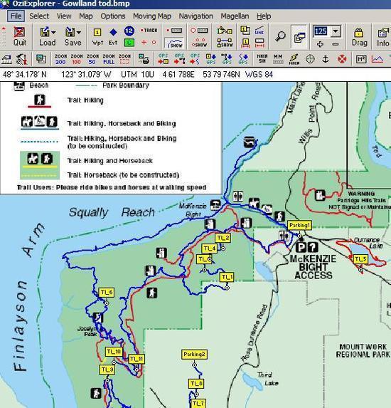
You can use an image file (ie. jgp, bmp etc) and it doesn't matter how you get it. The image below is a map I created in OziExplorer. The background map is a PDF file that I downloaded from the BC Govs Parks website. I converted the PDF map file to a JPG and registered (skewed) the map to some known coords. The red lines on the map are the trails shown on the BC Parks map and the blue lines are my GPS tracks overlayed onto the PDF. The yellow markers are waypoints I've added in OziExplorer.
All of the tracks and waypoints can be loaded directly onto your Garmin (but you can't upload the map image). OziExplorer also imports GPX files and ESRI Shapefiles which is handy. You can download a trial version of OziExplorer but it's a bit lame compared to the fully functioning version but you can get an idea of whether or not you think it's worth the investment.
 Oct 3, 2010 at 6:11 pm #1651109
I've installed the new TOPO! Explorer app and its $24.95 for the app plus superquad credits. Just looking at the superquads for the areas I'm interested in, it looks like the trails are available. Should I consider this as a solution?
-
AuthorPosts
- You must be logged in to reply to this topic.
Forum Posting
A Membership is required to post in the forums. Login or become a member to post in the member forums!
Our Community Posts are Moderated
Backpacking Light community posts are moderated and here to foster helpful and positive discussions about lightweight backpacking. Please be mindful of our values and boundaries and review our Community Guidelines prior to posting.
Get the Newsletter
Gear Research & Discovery Tools
- Browse our curated Gear Shop
- See the latest Gear Deals and Sales
- Our Recommendations
- Search for Gear on Sale with the Gear Finder
- Used Gear Swap
- Member Gear Reviews and BPL Gear Review Articles
- Browse by Gear Type or Brand.
