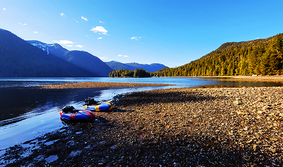
Last spring, BJ Brewer, Matt Gelso and I made a 15 day packraft-based crossing of the South Prince of Wales Wilderness on Prince of Wales Island, Alaska. The idea of this trip was to traverse a rarely visited wilderness area, spend time in old growth costal rainforest, and fish some of the most remote and rarely visited steelhead streams in the United States.
Here’s a link to a photo album – https://photos.app.goo.gl/6gE3cFYEsRctQWFW6
For the first nine days we had amazing weather – 60 degrees and sunny. For April in SE Alaska, it was weird. We weren’t sad about it to be sure, but it made for tough fishing. Low clear water meant the steelhead we found were very spooky. We saw more than we hooked, and hooked more than we landed. Which is pretty much steelhead fishing in a nutshell. That said, paddling up to a stream that might not have been fished in the last 25 years, hiking up it, and finding a perfect, fresh out of the sea fish, never stopped being magic even when we didn’t connect to them. When the rain started day 10 the fishing got way better.
For the most part, I feel like the pictures in the gallery convey the experience pretty well, but in no particular order, here’s some thoughts, experiences, and lessons learned that stand out. I’d be happy to answer any questions if far more detail if anyone has any.
- The pack rafts performed way better in the saltwater than we’d expected. We averaged almost 3 mph paddling, and went 26 miles on flatwater one day. At first we tried really hard to time going with the (very large) tidal currents, but were just as effective going directly against them and eddy hopping up the rocky, point-ridden coastlines. We also made one large crossing (we were a couple of miles off shore at one point). For me it was spooky, and is probably the most dangerous thing I’ve done in a packraft, but was totally manageable despite 4′ swell and some wind. I did have one exciting moment on that crossing when a sea lion popped up straight beside us.
- Salt Chuck Rapids are very, very cool. Here’s some video – https://photos.app.goo.gl/YPeyNCXNDkzjfLNd7. It’s just wild to see huge volume rapids that change completely (sometimes swinging 180 degrees) with the tide. You could do a really cool trip up there just lapping salt chucks, it would be a different rapid every time.
- Winter 2020 was very wet and snowy on Prince of Wales, and we encountered a significant amount of snow on one overland crossing that, added to full value Tongass bush whacking and log crawling ,lead to us going 6 miles in 17 hours spread over two days. I don’t know when the last time before us a person crossed from Klakas Inslet to Nutkwa Lagoon, but I would only recommend it to Type 3 fun aficionados.
- Tide charts are at best an approximation on a coastline that complex. Matt and I underestimated it’s height potential one night and got rewarded with a 1AM gear drying session. Could have been a lot worse, but the bathtub floor on the HMG Ultamid worked really well. I’ll never forget waking up, having Matt slap the floor between us and it making the exact sound and motion of my childhood water bed. But all our stuff stayed dry until we opened the door.
- We did one day of raft-packing (instead of packrafting) on a river too low to actually run much of. So we just dragged loaded boats down the river. Long 1/2″ webbing tails for the stern of the boats were really nice to have in that situation.
- I would kill for a simple test that would let you check mollusks for Paralytic Shellfish Poisoning. I know it’s a pipe dream, but there were some campsites with ACRES of mussel beds at low tide. Combined with sea cucumbers (delicious!), salmon, mushrooms and berries, in the fall, you could probably do the whole route carrying practically no food and live like a king. We already have plans to go back and do that exact thing in a few years.
- Overland travel in the Tongass is all about finding and using muskeg travel lanes. The difference between being in the forest or sometimes even 30 feet one side on the muskeg is a 90% increase in ease of travel. Pre-downloaded high-res satellite imagery on our phones combined with GaiaGPS (me), CalTopo (Matt) or OnX (B.J.) was game-changing. Navigating in devils club and downfall so thick you can’t see 10 feet in any direction is way easier with a GPS than it is with a 7.5 minute quad. Even so, we did some gnarly bushwhacking. At one point we did a “first descent” on a 200 yard long pond, because it was faster to transition completely from hiking-paddling-hiking than it was to walk that distance.
- I had the best partners in the world. They laughed when it was miserable, were strong when I was weak, and were as deeply grateful as I for how amazing the Tongass is. Being with them made the trip for me. I would go to the end of the earth with those guys.


Home › Forums › South Prince of Wales Wilderness Packraft Traverse