The Elkhorn Mountains are a small range in Central Montana, close to my home town of Helena. The are probably most famous for the trophy elk opportunities they offer, but only for the very lucky few that draw a special permit to harvest a bull (I’ve been putting in for 25+ years and still haven’t drawn!). The range also had a long history in mining for gold and silver in the mid to late 1800’s (and even a bit beyond). The history of the ghost town of Elkhorn is very interesting (and sad).
Back to the traverse; I had bagged four of the five highest peaks previously, but had never considered giving all five a go. The FKT attempt is somewhat tongue in cheek as I don’t know of anyone who has ever done it :). I came up with a tentative route, tentative as things could easily change based on what was seen on the ground. The route I mapped out was just shy of 30 miles and in the neighborhood of 8500′ of gain. Roughly half those miles would be off trail and include a lot of slow going talus fields. The other half of the route that was on trail, would include a good chunk on very under maintained trail. Basically, this wouldn’t be a walk in the park.
Based on what I had seen on previous outings, I knew I didn’t want to go at this solo. I floated this route out to four good friends, thinking maybe someone would be up for a little suffering. Turns out my four friends are as at least as crazy as me. Within in minutes of emailing the route out, I got four “I’m in” responses!
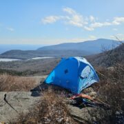
A little background on our summer in Montana. It’s sucked! Turned off extremely hot in early June (talking 20 degrees above normal) and has stayed extremely hot through the beginning of August. The spigot was also shut off in early June and set us up for a very bad fire season. Heat + dry + smoke = sucks! The thought of busting our butts off and not getting the well earned views was a major concern. We rolled the dice and decided to give it a go the following weekend. The plan was to start in the south (near the town of Elkhorn) at 4-ish AM in headlamps and finish in the north, most likely in headlamps again.
A vehicle was left at the north trailhead on Friday evening and at 3:00 AM on Saturday we took another vehicle south. At the trailhead the temperatures were in the low 50’s at the trailhead and you could see stars with no smoke clouding the view- a good start! 4:24 AM
As we approached the first peak (Elkhorn) just at first light, we were greeted by a couple of mountain goats. Their ability to move through the jumbled talus/rock is always a site to behold.
At Windy Pass just below Elkhorn Peak.
At the first peak in a hand fashioned wind break (left to right Andrew, John, Tom and Dave) 6:24 AM
No time to dawdle, headed for Crow Peak
We took a little breather at the base of Crow Peak
And then submitted our second peak of the day- Crow Peak 7:45 AM
We headed off trail to catch a trail that would lead us down into the Tizer Basin, headed roughly north for the other three peaks. All the hard earned elevation given up.
We had a little snafu with one of the members of the group getting off the route, but eventually got everyone back together.
The Tizer Basin had a fair bit of water flowing so took opportunities when they presented themselves to water up.
We ended up bumping a few elk along the way; it’s really prime elk habitat- water, numerous meadows to graze and plenty of security cover.
We took a nice lunch break at Clear Creek, watered up good as the sources would get very thin and started to ascend again.
I should add that it continued to stay mostly smoke free and though it was warming up, there was enough cloud cover coming and going, that it wasn’t too bad.
Our next peak was Crazy Peak. This is the one peak I had never been to before (nor had anyone else in the group). Getting close to the peak we used a very under maintained trail- lots (and lots) of blowdown. Blowdown simply wears a person out- under, over, around, repeat. Eventually we left the trail and headed for a ridge line that would get us to our third peak. You simply can’t get away from the jumbled talus on any of these peaks. The going is slow as a slip could easily mean an injury.
I have to admit I was a little disappointed when we gained this ridge as I though the peak was going to be pretty close, seemed a long ways off (and a lot more talus to contend with)
Getting close now
and bingo, the third peak! 5:06 PM
We had some pretty nice views, but we needed to press on. We did NOT want to be in-between High Peak and Casey Peak in the dark, we wanted to be on that last peak before dark.
It was a relatively straight shot to High Peak and we made pretty good time, despite the rock.
We made High Peak at 6:33 PM which would give us enough time to traverse the rocky jumble between High and Casey Peak. Took a short supper break and soaked in the views.
We started for Casey Peak, the last of the five peaks. I knew would be fighting a lot of talus enroute, what I hadn’t expected was the amount of blowdown we would also fight. That’s not a winning combination in my book, but we pressed on and eventually made it to Casey Peak at 8:12 PM. The remains of an old lookout.
The view from here gave us a commanding view of the Big Belt Mountains on the other side of the Missouri River. In very plain view were the plumes of the Woods Creek fire (at ~ 40,000 acres burned at the time).
We did it, well almost, we still had 6 miles of trail to get to our waiting vehicle, but the hard part was over!
Just as I predicted beforehand, start in headlamps, finish in headlamps
We finished at 10:24 PM a full 18 hours after we started. My gps showed 28 miles with 8400′ of ascent. This is one of those trips where you knew you had accomplished something special, but also one of those trips you’re not likely to repeat :)


Home › Forums › Elkhorn Five Peak Traverse FKT attempt