July 23, 2021 – July 30, 2021
The Circle of Solitude is a loop through Sequoia and Kings Canyon National Parks. The route, described by guidebook author Mike White starts in the western Sierra at Roads End and is a 68 mile loop. My route started at Onion Valley, in the eastern Sierra and ended up being around 85 miles. Much of the route became more popular in recent years as a shortcut of the Big SEKI Loop. Regardless, I decided to venture out and see if I could find some quality time alone in the woods.
This was my first long (for me) trip in several years, so there was no telling how it would go. Strap in and come along for the ride!
The attached video is pretty rough. This was the first time I ever shot any video on a trip and the first time I’ve ever tried to edit it together. I had no idea what I was doing when I was shooting or editing it. While it’s pretty second rate as far as production quality, hopefully it gives a good feel for the route.
Day 1 – Getting started, ~2.5 miles, ~1200′ up
The trip started with putting in a short day at work, getting in the car, and making the five hour drive from home out to Onion Valley trailhead, outside of Independence, CA. As tends to be the case, the pack was heavy on day one, but luckily for me, I was only going a short distance. After climbing up into the John Muir Wilderness, passing Little Pothole and Gilbert Lakes, I settled in on the shore of Flower Lake, at an elevation of approximately 10,400’.
Day 2 – Getting moving, ~10 miles, ~2500′ up, ~3500′ down
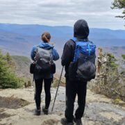
Now it was time to get moving and into the backcountry. Onion Valley is a popular trailhead with lots of day hikers and people looking for a quick outdoor adventure. If I was going to find that solitude, I would have to make it over Kearsarge Pass and into the true backcountry. It’s a short, steep hike up to Kearsarge Pass, passing some more beautiful scenery on the way. Above Flower Lake lies Heart Lake and Big Pothole Lake. Then at 11,760’, Kearsarge Pass marks the point where you leave Inyo National Forest and enter Kings Canyon National Park.
Below the pass lies the wonderful world of the Kearsarge Lakes and Bullfrog Lake. This series of alpine lakes is nestled west of the Sierra Crest, with the soaring Kearsarge Pinnacles to the south, Mt. Gould, Mt. Rixford, and Glen Pass to the north, and the vast high Sierra to the west.
It’s a long descent from the pass, passing by the Kearsarge Lakes and eventually joining the John Muir Trail for a short stint. Once on the JMT, it’s down a steep set of switchbacks into the wooded wonderland that is Vidette Meadow. Dropping into Vidette, the scenery changes from the rocky ridges above treeline and alpine lakes to a pine forest filled with ferns and corn lilies.
Once in Vidette Meadow, you intersect the Bubbs Creek Trail and leave the JMT. The Bubbs Creek Trail is popular with people doing the Rae Lakes Loop, both from Roads End and Onion Valley. There’s still no solitude, but the scenery is fantastic! I’ve been down this portion of trail a few times and it never fails to impress me. Bubbs Creek cascades its way from its headwaters on the north side of the Kings – Kern Divide, down to its confluence with the South Fork of the Kings River.
After following Bubbs Creek for about 2.5 miles, I decided to take a side trip and spend the night at East Lake. From Junction Meadow at about 8200’, it’s a short, steep climb to the south along East Creek, to East Lake. From the moment I left the Bubbs Creek Trail, this felt like the kind of place where I would find some solitude!
The trail up to East Lake is obviously less traveled. It’s a little overgrown in places, has much less effort put into building it, and sees many fewer feet on it. However, it does not fall short in the scenery category. East Creek tumbles down about 1300’ in a couple of miles on its way to Bubbs, West Vidette towers above to the east and the Great Western Divide flanks the southwest.
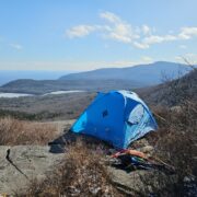
I did pass a family on their way up to spend a week at East Lake at about 9500’. Other than that, not another soul in the area. I set up a ways away from the main camping area on the north side of the lake, since I figured the family would want to occupy that site. From my perspective, I had the place to myself. Ahh, some solitude at last.
Day 3 – Getting the hang of it, ~10 miles, ~2500′ up, ~3500′ down
In the morning, it was 2.5 miles back down the Junction Meadow and the Bubbs Creek Trail. Below Junction Meadow, the trail continues to descend through pine forests, with thick undergrowth, along the flank of Bubbs Creek, occasionally ducking in between huge boulders.
The trail continues dropping as Charlotte Dome and other granite cliffs tower overhead. It becomes pretty evident why the park is named Kings Canyon. Eventually the Sphinx, a strange rock formation comes into view, high above on the south side of the canyon. The Sphinx (which looks like its namesake in Egypt when viewed from the west, looks like something else from the east) marks the turn to the south towards Avalanche Pass. After almost 7 miles on the Bubbs Creek Trail, you reach Sphinx Junction, where the trail to Avalanche Pass and the Roaring River breaks off to the south.
This is a steep climb, on a surprisingly well constructed trail. While it only sees a fraction of the use that the Bubbs Creek trail sees, the stonework is amazing and it was a bold decision to build a trail through this section of the Sequoia – Kings Canyon Wilderness.
It’s about 5.5 miles up to Avalanche Pass and there aren’t much for good spots to camp in the lower reaches. About half way up, the trail crosses Sphinx Creek. I’d hiked up to this spot, but found it a little swampy and buggy for my taste, so I backtracked about a mile and camped near a small side drainage that was flowing down to join Sphinx Creek.
Day 4 – Getting to see the weather change, ~14 miles, ~3200′ up, ~2800′ down
The morning brought sunshine again. It’s nice to be gaining some elevation and escaping the heat down below. Sphinx Junction, the low point of the trip, is at 6280′, and with a bit of a heatwave going on, was a bit uncomfortable. Above Sphinx Creek, the trail abandons the granite walls to the east and goes through the forest to the west of the creek until finally reaching Avalanche Pass at 10,013′.
The south side of Avalanche Pass descends about 2500’ to the Roaring River. From there, it’s up another 1500’ up Cloud Canyon to camp for the night. The trail was a little obscured in some parts of Cloud Canyon, but still easy to follow. There were beautiful meadows, cascades, and wildflowers along this section.
Eventually, the Whaleback comes into view and storm clouds are building, but I’m getting close to being finished for the day. Got to hear the sound of rain and the rushing creek all night long.
Day 5 – Getting worked, ~12 miles, ~4200′ up, ~4200′ down
After a night of rain, the sunshine was back. Thankfully the rain had stopped about half way through the night, and all of my gear was pretty dry. It didn’t take long and I was on my way up. First you cross over the northern flank of a formation called the Whaleback and then tuck in behind it, before reaching Colby Lake at 10,584′.
Above Colby Lake looms Colby Pass. It doesn’t look possible that there’s a path up there, but as you get closer, the trail work begins to reveal itself in the sea of granite blocks. This is probably some of the steepest constructed trail I’ve ever been on and an audacious undertaking for the trail builders. However, the work goes by quickly and eventually I’m at Colby Pass, 11,970′, and on top of the Great Western Divide. This portion of the Great Western Divide is the hydraulic divide between Bubbs Creek (Kings River) and the Kern River.
The east side of Colby Pass is amazing, all the way down to the intersection with the High Sierra Trail in Junction Meadow. Alpine meadows, lakes, waterfalls, cascades, soaring granite walls; it has it all…except people. I did come across two other guys that were hiking up as I was going down. They were very surprised to see me. I wasn’t sure what to think when I saw them.
As you follow the Kern Kaweah River down to the east, you think it’s going to be easy going all the way to Junction Meadow. Then you see something strange. The trail leaves the river and climbs very steeply onto the granite benches to the left. It actually tucks into a side canyon, completely separated from the river, and eventually pops out the other side just before Junction Meadow.
In the quest for solitude, I leave Junction Meadow behind and climb out of the bottom of the Kern River drainage and camp a mile north, and about 800′ higher.
Day 6 – Getting a break, ~8 miles, ~2700′ up, ~600′ down
I have some options today. I can head north and explore the headwaters of the Kern River or head east and join the John Muir Trail. My original plan was to head north and loop up around Lake South America. What actually happened was something else. I was feeling pretty beat from the previous day and the clouds were already building when I got out of camp, so I opted for a short day. I followed the HST east for about 3 miles to its junction with the JMT. Then it was north, across the spectacular Bighorn Plateau, to my camp at the north end of the Tyndall Creek area.
I’m glad I made this decision as I could definitely use the break and there was some pretty heavy weather that came through that afternoon. I was much better off sitting in my hammock, under my tarp that I would have been, exposed, up by Lake South America.
Day 7 – Getting up high, ~ 15 miles, ~3300′ up, ~3800′ down
Today I hit the high point of the trip, Forester Pass, at 13,153′, on the Kings – Kern Divide. I’d slept in a little bit, which didn’t seem like a good idea as I watched the clouds building. However, it was only about 4.5 miles up to the top of the pass, and I was up, over, and on my way down before the rain made another appearance. The trail to the pass, on the south side, takes you through some great alpine terrain, passing Diamond Mesa to the east and Caltech Peak to the west.
Coming off the north side of Forester Pass, you pass Center Peak and it’s ridge that extends south to Junction Peak. This separates the JMT corridor from Center Basin and the location of the original JMT, which went over Junction Pass, before the construction of Forester Pass in the 1930s.
Eventually you hit the upper portion of Bubbs Creek and find yourself entering the forest again. After about 7 miles from the top of the pass, you close the loop, back in Vidette Meadow, right where I was at back on day 2. I make the decision to go up to Charlotte Lake for the night. Somehow, I manage to avoid heavy weather and make it into camp experiencing little more than a light rain. If I had been an hour or two earlier OR later, it would have been a different situation. I guess fortune really does favor the foolish.
Day 8 – Getting to go home, ~ 9 miles
Ah, the final day. This was a straight forward cruise, taking the high trail rather than the lower trail that runs closer to Kearsarge Lakes, up and over Kearsarge Pass again, and back down to the car. Not much to report here.
Let me know if you have any question about the route!