Topic
Garmin inReach Mini Review
Forum Posting
A Membership is required to post in the forums. Login or become a member to post in the member forums!
Home › Forums › Campfire › Editor’s Roundtable › Garmin inReach Mini Review
- This topic has 109 replies, 14 voices, and was last updated 2 years, 2 months ago by
 Normand F.
-
AuthorPosts
-
Jun 27, 2018 at 11:52 am #3544006
Thanks for that, @ryan! While I recognize size does not necessarily imply reduced signal gathering strength, reducing it could have been part of miniturizing an already great device.
I’m definitely considering ‘trading down’ to this from the full size.
Jun 27, 2018 at 12:25 pm #3544011@idester-2-2. The download is free, so they can download the app without paying anything.
Thanks, Doug, for clarifying. I wasn’t aware of that. Carry on.
Jun 30, 2018 at 2:03 pm #3544599I just don’t find smartphones that useful or desirable in the backcountry. YMMV.
Well, the point really isn’t desirability in the backcountry. Y’know, HYOH, but by far most of us drive a fair distance to start our hikes. And on such a drive you’ll most likely want your phone with you, especially if your plan includes a stay at a motel or whatnot. And then what are you going to do- leave it in the car? Right. So if we’re going to have the smartphone with us anyway, then if we can make it useful so much the better. Basically, it’s the weight of a very nice display screen that you’re already carrying that can be removed from your InReach, and this device does that.
Not to mention that there is a certain demographic in the US (*cough* *millennials*) who simply are not going to be without their smartphones at any time, anyway. :)
And, heck, it’s also your camera.
Jul 1, 2018 at 1:18 pm #3544684smartphone weighs less than dumb phone + GPS + camera + mp3 player + FM radio
Jul 1, 2018 at 9:26 pm #3544755Superb review. Well done.
Any chance you can post a few screen shots of what the weather forecast looks like on the Mini’s screen? Is it very readable? I’m trying to figure out if I would need to bring a phone for that feature. We use an Explorer+ at work and get marine forecasts through the device provided by Ocens. They are excellent. The benefit to having a map interface is that you can scroll offshore, drop a pin, and get a forecast for that location. If you ask for a forecast for your present location (the only option if you don’t have a map or preset locations) when you are still anchored in a bay it either won’t work- it doesn’t consider you on the ocean- or it gives the actual bay forecast which is obviously much nicer than it will be offshore. I guess you could preset a number of locations (mountain tops, etc) before the trip and then request forecasts for those from the Mini’s list.
Cheers
Jul 2, 2018 at 7:36 pm #3544922
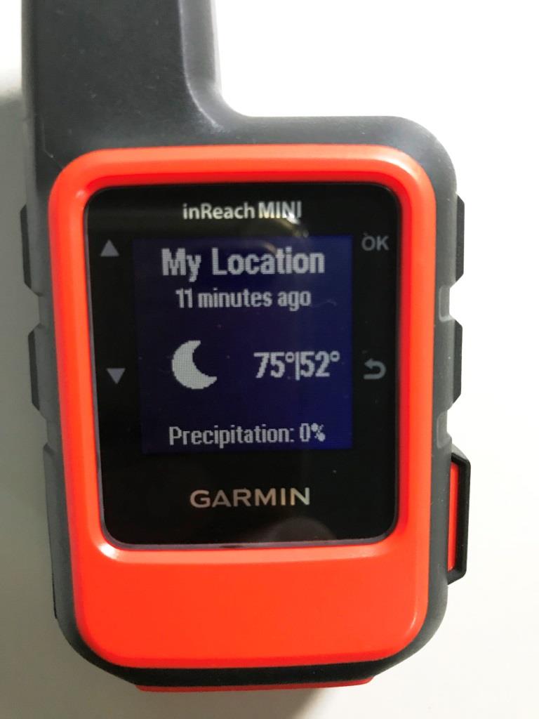
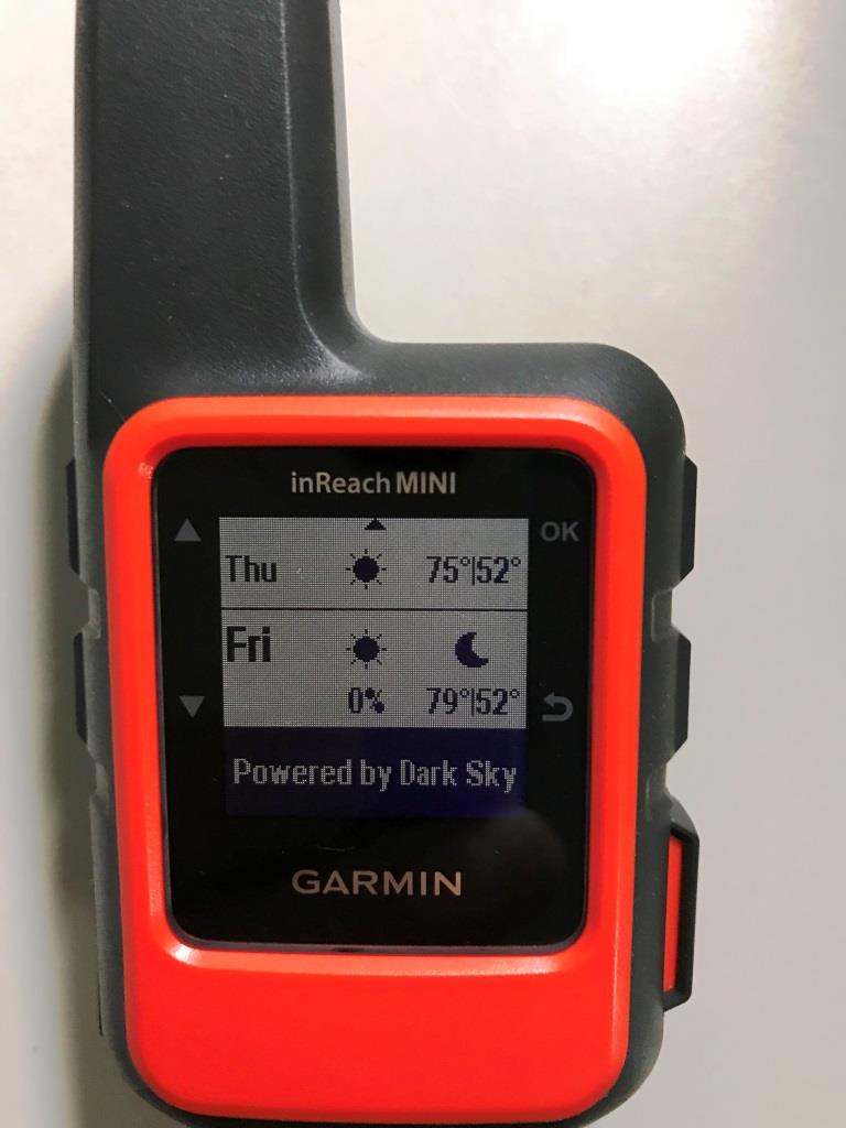
The first photo is a “Basic” satellite weather forecast requested and then displayed using the Garmin Earthmate app on your smart phone. The next two photos show a “Basic” satellite weather forecast requested and then displayed using just the Garmin Mini.
Jul 3, 2018 at 1:21 am #3544958Okay, thanks. That’s a start. Wind direction and speed here in coastal Alaska basically spell everything, and I’m guessing you need to turn the ‘premium’ weather on to get any of that. The marine WX is not free, but very detailed and accurate (well, aside from wave height but we can deduce that ourselves from wind speed and direction which is bang-on). I’m hoping the ‘premium’ terrestrial weather is similarly useful.
I have a mini now to replace my recently retired epirb, and I should just pony up the $1 and find out for myself what the premium weather looks like, lol.
Jul 3, 2018 at 4:03 am #3544990A marine forecast looks like this (won’t look quite like this on your Mini though):
Here’s a page showing various forecasts you can get via the inReach devices and what they look like.
You can also enter coordinates before asking for the weather for a location other than where you are.
Jul 3, 2018 at 4:18 am #3544991You can also get coastal forecasts for free using WX2InReach. (Well, free as in they only count against your email allotment, no extra charge). Not as pretty as the Garmin one you pay for, but might have the info you want … perhaps worth checking out.
Jul 3, 2018 at 5:10 am #3544994I’m pretty familiar with what things look like on the Earthmate app interface, but I’m trying to figure out if I really have to drag my phone along on trips. Maybe I’m just dumb, but I can’t figure out how to access premium weather or marine weather from inside just the Mini weather interface itself. I’ve been a little dismayed at the amount of stuff you need to preset on the Garmin website, sync via the inReach Sync desktop application, and then still futz with the Earthmate app and the Mini. Woe be to the technophobe.
I just did a WZ2InReach ‘io’ (darksky) forecast using one of the preset (free) messages for a mountain in the center of Kodiak Island using “wx now io loc 57.61 -152.97” and checked it against yr.no (a sweet Norwegian weather site that will give a specific forecast for just about ANY geographic placename) and it seems pretty good. I think I may just go that route.
Jul 3, 2018 at 5:23 am #3544996From the main screen after turning on, hit the up arrow once, brings you to weather. Click OK. With Update highlighted (center screen), hit OK. Now you can choose between Basic, Premium, Marine Basic and Marine Premium.
Jul 3, 2018 at 5:52 am #3544997Wow. How did I miss that earlier? Lol. Thanks. I have to say the online help/manual on the Garmin site is pretty skinny.
Jul 7, 2018 at 4:24 am #3545743I had a Spot Gen 1, then a Spot gen 3, but I dumped both of them for an inReach Explorer+. The 2-way messaging was a big plus, but the biggest issue was that Spot’s annual subscription fees kept going up. For a person that only gets out 10-20 nights/yr, the pay-as-you-go plans for the inReach were much more attractive.
Anybody wanna buy a Spot Gen 3?
Jul 20, 2018 at 3:15 am #3547578Ryan,
Absolutely phenomenal review. Love your thoroughness and real world examples. I was searching for the battery mah so that I can plan/ration my battery bank needs for the JMT next month. Thanks! You should write manuals. I would read them!
I used my mini on a solo hiking trip for the last three days and it was perfect. The texts and sharing location with family and friends made it a little less solo (in a good way). Weather was perfect in the Cascades so I didn’t “need” weather services but got them for fun.
One quick question. Is there a way to plot the altitude of a track I have made? Either on my phone or at home on a computer with internet?
Great job!
Jul 20, 2018 at 10:40 am #3547615Andrew,
I think you could export your file into Caltopo and view the elevation of your route there, but perhaps someone can verify or has a better way.
Jul 22, 2018 at 12:36 am #3547848With a great deal of head-scratching and manual editing, I managed to get inReach SE points into Google Earth and plot a track elevation:
https://backpackinglight.com/forums/topic/90733/#post-211780
Possible, but not recommended. Must be an easier way.
— Rex
Jul 22, 2018 at 4:51 am #3547873Brad and Rex,
thanks for the replies. I’m wondering whether I am the target demographic of the device as I would think most hikers would want this. It seems like since the altitude data is in each tracking point, it would be easy to implement to graph a route or track. That would make planning trips more visual as well. Like most other GPS or baro watches do, at least after the fact. Perhaps there is a reason for not including. Perhaps an error of omission, like no altitude on waypoints.
I don’t have the patience to export to another program, unless it was life-threatening . Although I could get altitude plotting from other software, I actually like tEarthmate. Plus, if included, I wouldn’t need two GPS power sucks going (phone and mini).
Still 9/10 device for me
Jul 22, 2018 at 10:45 am #3547900Late to the party, just found out about the Mini and then found this review – great job, very informative! I’ve been using the inReach since 2014, first with an SE and now an Explorer… and now might have to downsize. :) The new Mini looks sweet, and I’m always carrying my phone anyway so it’s not a big deal to me if the interface on the Mini isn’t as nice. About the only thing I do regularly on the Explorer itself is send a preset message by holding down the “X” key. If that’s as easy to do on the Mini, then I’m sold. Anything having to do with maps I’m using the phone, it’s just so much more functional.
I wanted to clarify an earlier comment:
Speech-to-text? Maybe on the Mini+ with Iridium Next. Siri, Alexa, and similar services rely on multiple microphones and fast Internet connections to translate talking using big fast computers in the cloud. Not likely to be crammed entirely into a handheld device soon.
Actually, iPhone 6/SE and up have supported this for a couple years now (referred to as “offline dictation”); can’t speak to Android but I think it’s a similar situation there. General Siri stuff (actual language interpretation/understanding) is a lot more complex and likely to be done in the cloud for a while. But basic text dictation works fine in any app that supports text input, including Earthmate. This is probably even easier than a dedicated keyboard a la Spot X.
Another random note. When inReach is paired to an iPhone, any mapping app used on the phone will use the inReach GPS rather than the phone’s, additionally saving phone battery. Or at least that’s how it’s supposed to work, it seems that it can sometimes switch back to internal GPS, some details in this link:
https://icmtgis.wordpress.com/2014/03/05/using-an-external-gps-with-icmtgis-ii-on-ipad/
Jul 27, 2018 at 12:21 am #3548534Very interesting review and posting thread, and for the first time in a long 40-year backpacking and mountaineering career, I’m actually contemplating something like this.
As a technophile, my curiosity runs more to how the device would co-exist with the rest of the Garmin/Apple ecosystem that I might already be taking on an extended backcountry trip. Specifically, there seems to be some functionality overlap between the Garmin InReach Mini and the Fenix 5x, particularly in the areas of GPS & mapping. Does anyone have any thoughts in that regard? For example, I may want to minimize the number of GPS location posts by the InReach if my Fenix is capturing all that data (hence reducing my service contract costs).
Jul 27, 2018 at 1:15 am #3548543I have the in reach mini and my understanding is that the maps that come with earthmate are not the usual TOPO maps you can get with the Oregon or Montana. I’m not sure what kind of maps come with the Fenix. I’ve never been a fan of watches that need recharging so I’m sticking with the mini. It may not be the best maps but decent enough to show major landmarks and where they are.
Jul 27, 2018 at 2:29 am #3548547Patrick,
You can get 24k maps (USGS quadrangles, 7.5 minute) with Earthmate by zooming the map section of Earthmate into the area of interest and then clicking the stack button in upper right screen and hit download (of USGS for example). If the area is too big (e.g., half a state), the download would overwhelm your phone’s memory. Pretty cool (and easy) to be selective. For data use reasons, you would obviously want to be on WiFi when you download. Once on your phone, it’s good to go off the grid.
One thing others could tell me is how to get maps OFF the phone to free up space.
Happy hiking!
Jul 27, 2018 at 2:37 am #3548548One thing others could tell me is how to get maps OFF the phone to free up space.
Click the same stack button in the upper right. In the popup screen that comes up at the bottom, click the “Manage” button . That will pop up a list of maps you have downloaded. Find the one you want to delete, and swipe to the left to reveal the Delete button. If you want more granularity, click the “i” button for the top level map in question (“Topo North America” for example). That will take you to another screen which will list all the sub-regions you’ve downloaded, and you can then do the same swipe-left/delete action on individual regions.
You probably have to reboot before seeing the space actually come back.
Jul 27, 2018 at 8:35 am #3548572I guess the USGS maps are ok for the lower 48 but the only decent maps I’m aware for Canada are the Garmin topo. I’ve found free stuff in the past but they were not as good as even the backroads maps. I paid for those at one time then they stopped updating my versions and stopped supporting them. Which I thought was weird since they were advertised as “lifetime” maps. I guess that just meant not subscription based.
Personally if I were to get a new GPS navigation device (I have a very old Oregon) I would probably shell out for the topo maps but the basic earthmate stuff will get me by.
Edit forgot to mention I have downloaded my province on my phone. Should probably pick up an SD card.
Aug 1, 2018 at 6:26 pm #3549413I’ve been using a Delorme InReach Explorer for a few years now with mostly positive results.
Besides the obvious physical differences, has any Delorme users upgraded to the Garmin Mini or the standard model?
Aug 14, 2018 at 3:30 am #3551304FYI
you can get routes created in the Gaia app to the Garmin mini without using a computer on an iPhone. What I don’t know is if it’s possible without having cellular internet access. I had to use the Garmin website to upload load a gpx file I saved on my phone in files.
It’s a nice use-case scenario benefit over my 2 oz sunnto ambit 3 peak for last minute trail changes at the ranger station ;), which makes me wonder if I’ll ever need both. I guess this makes it more reasonable to bring your iphone… darn now that means I’m brining the zebra light instead of a petzl so I can charge stuff off a 18650. How did this turn into a pound already? Lol.
-
AuthorPosts


- You must be logged in to reply to this topic.
Forum Posting
A Membership is required to post in the forums. Login or become a member to post in the member forums!
Our Community Posts are Moderated
Backpacking Light community posts are moderated and here to foster helpful and positive discussions about lightweight backpacking. Please be mindful of our values and boundaries and review our Community Guidelines prior to posting.
Get the Newsletter
Gear Research & Discovery Tools
- Browse our curated Gear Shop
- See the latest Gear Deals and Sales
- Our Recommendations
- Search for Gear on Sale with the Gear Finder
- Used Gear Swap
- Member Gear Reviews and BPL Gear Review Articles
- Browse by Gear Type or Brand.
