Introduction
After some Type 2 fun triggered by following an overgrown path, I decided that for solo hikes, I would stay on well-maintained trails using simple backpacking navigation. Hoping to keep out of similar situations, I dragged an impressively heavy collection of paper maps on every trip after that.
Then, several years ago, I started planning a 100-mile loop through Marin County, California, using the usual combination of downloadable maps and online resources. At some point, while struggling with the idiosyncrasies of Google Maps, I realized that printed turn-by-turn directions might be useful while hiking.

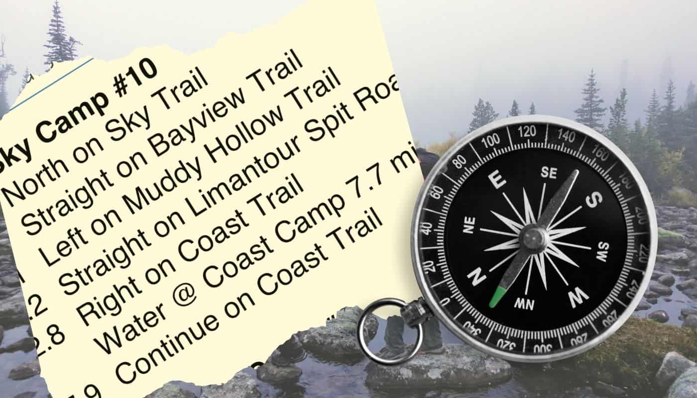
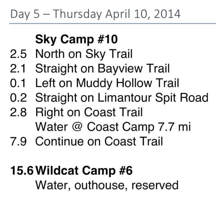
Unfortunately, Google trail names often differ from local trail names, and even our omniscient online overlord misses some trails or trail connections entirely, so I couldn’t just print those directions and move on. However, I could get local trail names and directions from park maps. I also wanted larger fonts and pocket-sized sheets. Since this trip relied on fixed, legal campsites each night, I made each day’s hike fit onto one cut-down piece of paper. I also added key information, like water sources (which were surprisingly rare on this trip), campsite numbers, and important camp amenities. After some experimentation, I came up with the following format.
Example
I was really pleased with how well these instructions worked for this eight-day trip, and rarely pulled out one of the six maps I carried. I still use this technique in areas with well-marked trails.
Advantages
- Faster and much less hassle than pulling a map out of a pocket, unfolding, orienting, squinting at small type and tiny features hidden in a forest of contour lines, head-scratching, sometimes realizing I’m off this map and onto the next, refolding, and stuffing back into a not-quite-big-enough Patagonia Baggies pocket, often accompanied by swearing through the whole process.
- Reduces my mental workload and lets me enjoy hiking more – though, after 50 years of backpacking and day hiking, I’m pretty good at trail navigation and staying found.
- Keeps important information like water sources literally right at hand.
Tips
- This works best in areas with well-marked trails and junctions, but might be tough for cross-country travel.
- It’s very useful to have a watch and a known hiking pace for dead reckoning navigation, so you’ll know roughly when your next turn should show up.
- Don’t be afraid to think “Oops, did I miss that junction?” It’s better to stop, pull out the map, reorient yourself, etc., versus plunging ahead while hoping it all works out.
Disadvantages
- You lose an innate sense of where you are, like mindlessly following spoken smartphone directions in an unfamiliar area. On the other hand, this increases the mystery and sense of exploration, even in well-traveled locales like Marin County.
- This method doesn’t work as well when you don’t know where you’ll camp each night.
- It’s hard to identify landmarks of interest, like lakes, streams, and peaks, though you could add a few, like “Mount Jordan 5 miles NW @ 1.2 miles,” or “Lake Mary on the right @ 2.5 miles.”
- You might change your route, lose today’s instructions, or need to exit early. You always need maps or a mapping app just in case.
- You could still go down the wrong trail, especially if you are dyslexic, though using compass directions and a watchband compass might help. Years ago, some jokester reversed a trail sign deep in the backcountry. I spent 20 minutes reconfirming my location and directions and exploring the wrong path before discovering fresh dirt at the base of the loose signpost.
I often make a spreadsheet with segment-by-segment mileage and other notes anyway, so creating turn-by-turn daily hiking sheets is relatively easy. For those adamantly opposed to carrying paper in the backcountry, you could put turn-by-turn directions on your smartphone instead.
Conclusion
I still carry maps for each trip and plan to try smartphone navigation soon, maybe after Apple, Google, or the Gaia GPS App add reliable turn-by-turn spoken hiking directions. “In 100 yards, turn left on the Coast trail,” or “At the next trail junction, turn right at the bright green outhouse.” I could route the voice to a Bluetooth boombox strapped to the top of my pack, automatically pausing my Grateful Dead playlist to announce the next turn. Or not.
Turn-by-turn hiking directions aren’t for everybody, but try them before you scoff and proclaim “Never!” Maybe you’ll like it. I do, for some trips.

Home › Forums › How to use Turn-by-Turn Directions for Simple Backpacking Navigation