Topic
A Complete Guide to the Wind River High Route – mile for mile, the finest non-technical Alpine route in North America
Forum Posting
A Membership is required to post in the forums. Login or become a member to post in the member forums!
Home › Forums › Campfire › Member Trip Reports › A Complete Guide to the Wind River High Route – mile for mile, the finest non-technical Alpine route in North America
- This topic has 23 replies, 21 voices, and was last updated 8 years, 2 months ago by
 Lester Moore.
-
AuthorPosts
-
Nov 21, 2013 at 2:06 pm #1310104
A Link: Complete Guide to the Wind River High Route
http://www.adventurealan.com/WRHR/index.htmWind River High Route – A Guide
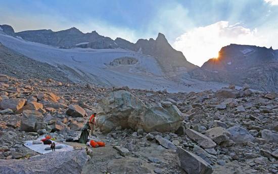
by Alan Dixon and Don WilsonThe Wind River High Route is in our opinion, mile for mile, the finest non-technical Alpine route in North America. It stays close to the crest of the Continental Divide in one of the most rugged and glaciated mountain ranges in the lower 48. The route is thrilling and the scenery spectacular.

Overview of the Wind River High Route
The Wind River High Route (WRHR) is similar in concept to the Sierra High Route (SHR) but Don and I feel that the WRHR is more spectacular and thrilling. Just as the SHR loosely follows the famous John Muir Trail (JMT) but spends much of its time off-trail, more closely following the Sierra crest, the WRHR in a comparable manner loosely follows the Highline Trail, many times going off-trail to stay higher and closer to the Continental Divide—a more elegant line in high glaciated terrain. When the WRHR uses trails they are higher trails, closer to the crest. It is a more challenging and more rewarding route than the Highline Trail.
The WRHR starts in the north at the Green River Lakes Trailhead and the headwaters of the Green River. It heads generally southeast to follow the Continental Divide, crossing it four times. After passing through the legendary Cirque of the Towers, it ends at the Big Sandy Trailhead. The WRHR is approximately 80 miles of off-trail and on-trail travel with about 20,000 feet of cumulative elevation gain. There are nine passes between 12,200 ft and 11,500 ft—six off-trail and three on-trail. Some of the off-trail passes have a fair amount of talus. There are few short sections of Class 3/4 travel and one glacier crossing. The recomended hiking season is late summer. This gives time for the high snowfields to melt out and reduces mosquito pressure. By mid September their is a decent chance of snow.
Our Criteria for Planning the Wind River High Route
- An elegant line closely following the crest of the Continental Divide along the finest section of the Wind River Range.
- A fit hiker should be able to do the route in seven hiking
days (we did it in 5½ days). This allows busy people to fit it into
a standard “one-week” vacation including travel days (two weekends
and the five weekdays in between = 9 days total). - A non-technical hiking route. No class 5 terrain. Short sections of class 3/4 terrain ok. Don and Alan did the trip in trail running shoes and trekking poles. [Late season only. Early season snow would significantly change the technical nature of the trip.]
- Route stays high but without being inefficient, or taking unnecessary risks to force a higher line.
- Uses convenient trail heads with an easy shuttle.
Resources for the Wind River High Route
- Text Only Version of Route Description (6) 8.5×11 pages [PDF]
- Full Mapset – (9) 11×17 pages [PDF
- Waypoints and Hiking Timetable [PDF]
- Shuttle Info
- Gear Lists [PDF]
- Other Published References (books, maps, etc.
- Potential Additions to the Route
Nov 21, 2013 at 5:45 pm #2047036deleted
Nov 21, 2013 at 8:01 pm #2047061Nice write up and guide now please delete all of this.
Nov 21, 2013 at 8:28 pm #2047070Indeed. I cringe when I see reports replete with maps and waypoints. Great way to ruin a place.
Bill
Nov 21, 2013 at 9:11 pm #2047076I tend to agree. The high places should be reserved for those that have honed their skills and can find their own way. Part of the draw is the adventure and this often lures less prepared hikers into a false sense of security.
I don't fault the authors for wanting to share a truly spectacular range and Pinedale would certainly like to increase tourism. I am very conflicted about promoting wild places. I left Cali because it was being loved to death and the inevitable regulation ruined it for me. We need more awareness and supporters but at what cost? The unintended consequences scare me the most.
At any rate the Winds are spectacular, remote (for the lower 48), unforgiving, and one of the few places you can go for days without seeing anyone else.
Nov 21, 2013 at 9:22 pm #2047078Quick, everyone go harass anyone who's ever published any information on the SHR.
Nov 21, 2013 at 9:27 pm #2047079Thanks Alan for sharing this. It looks like a great trip, maybe I can convince my wife to do it with me this summer. I have to admit I am a bit skeptical about your claim that it is better than the SHR :)
I disagree completely with the requests wanting this removed. We have all learned about cool places from others and none of us are more deserving than anyone else. Besides, an off-trail route with class 3/4 terrain is never going to be overrun with the great unwashed masses.
Nov 22, 2013 at 7:04 am #2047120Thanks for sharing Alan. I support posting routes for an awesome trip.
Nov 22, 2013 at 7:15 am #2047126Thank you Alan. A very well done report of a wonderful area.
I have hiked much of this route (more than once) and it is spectacular. The variety of terrain over such a short distance is stunning. And I'll be going back. Thanks for the reminder.
Nov 22, 2013 at 7:51 am #2047135Alan thanks for the EXCELLENT write up with documentation! Your trip report brings back many awesome memories of the family "winds" adventure in the early 80's that touch in the eleven days we were there many areas you covered and the trip we have place on the families top three adventure…….
"Life is known only by those who have found a way to be comfortable with change and the unknown. Given the nature of life, there may be no security, but only adventure."
Nov 22, 2013 at 8:42 am #2047149Thanks for your detailed trip report, maps and photos. There is some great footage of the route and even the impressive storm-worthiness of your tarp on the video.
Your guide to the cross country route through the area is great, which I think is fine because 99% of hikers (who mainly stay on trail) will never bother to read this. If they do the words 'Class 3/4' will surely keep most away. The people I have come across in the backcountry who enjoy this kind of trip seem well versed in LNT and backpacking etiquette.
That being said I respect the desire to keep the wilderness wild. Over the years my brother has taken a few of us to one of the 'secret spots' he has discovered in the Sierras. We have all agreed not to tell anyone about the locations. After over 20 years and even on busy summer holiday weekends these places are still usually vacant.
Nov 22, 2013 at 9:37 am #2047160Yeah, because the WRHR is some sort of secret that no information or maps exist for. Ha! Thanks for sharing, Alan and Don. Just be sure to stay away from my favorite powder stash ; )
* edited abbreviation
Nov 22, 2013 at 10:14 am #2047171A bold claim. The modest vert to mileage ratio has me skeptical, but we'll let it ride.
While I doubt this route will ever get crowded, guides with this level of specificity and luxuriant detail are exactly the sort which significantly increase traffic. I prefer more vague beta which leaves more space for ambiguity and adventure. But you can always just print the overview maps and refuse to read guidebooks.
Nov 22, 2013 at 3:08 pm #2047243 AnonymousInactive
"I disagree completely with the requests wanting this removed. We have all learned about cool places from others and none of us are more deserving than anyone else. Besides, an off-trail route with class 3/4 terrain is never going to be overrun with the great unwashed masses."
+1
If you who criticize really want solitude, get creative and design your very own secret route. There are dozens out there waiting to test your creativity, both in the Sierra and The Winds.
Nov 23, 2013 at 8:35 am #2047399Traversing the northern end of the high country via shale mountain/the continental glacier/dinwoody glacier then throwing in a climb up gannett then down into titcomb basin would only make this route better it seems. Several CDT hikers did it this year without any technical equipment and said it was great. Not sure where the best start would be for that though.
Nov 23, 2013 at 10:27 am #2047431Your photos really did capture the expansive views nicely, I gotta figure out how to do that.
Nov 25, 2013 at 5:49 pm #2048062Wow. Take this down, immediately…
Nov 25, 2013 at 6:47 pm #2048083I've been in the middle of a very popular area in the Sierra and not seen a sole for four days.
Another source for off route in the Winds is a book by Nancy Pallister (sp). She's an old hand at the Winds, even spent weeks up there in the winter.
DuaneNov 25, 2013 at 6:47 pm #2048084uuuuhhh Dean….
Seriously?
Sarcastically?
Humorously?
Nov 25, 2013 at 6:48 pm #2048085Too late. It's on Facebook.
Nov 25, 2013 at 6:50 pm #2048089I'm seeing a Skurka map-pack released as a "public service" for the low low price of $22.99.
Feb 21, 2015 at 8:36 pm #2176538Some Sierra Designs merchandise and a map pack and I am ready.
Feb 9, 2016 at 9:17 am #3381052I just posted this in response to the follow Q in the Southern Sierra High Route – A Guide Forum Post . Austin Lillywhite is “trying to decide whether to operate on [this route] or Skurka’s.”
A: As to the WRHR. They are both great trips. Just different. Depends what you want to do. Andrew’s route is excellent! It is longer, a bit harder and indeed takes in the most glaciated terrain in the North. E.g. the Dinwoody Galcier and has the option to summit Gannett Peak the WY high point. But to do that Andrew’s route skips Knifepoint Glacier, Indian Pass, Indian Basin and Titcomb Basin. All are stellar, beautiful and highly desired areas in the Wind Rivers that Don’s and my route go through. Don’s an my route is designed so that mere mortals can complete it in a long-week, including transport logistics at both trail heads. Andrew’s would likely take longer.
Take you pick. You can’t go wrong ;-) -Alan
Q: > One final question: in late August I have a chance to do the WRHR. Trying to decide whether to operate on your guide or Skurka’s. I know Skurka has yet to release his official pay-for version, but I was wondering what your two cents are on his claim that only his version “maximizes the full potential” of the northeast corner of the range.
Feb 9, 2016 at 10:15 am #3381058Thanks Alan for wetting my apatite for the Winds again. An early 90’s trip to Titcomb basin and soloing Gannet was a life changing experience. Have been back to the northern Winds 5 times but would love to see the rest of the range – hopefully in 2017 with a buddy who’s interested.
Will – you’ve got the right idea. Looks great to go over Shale and Downs Mountains starting from Trail Lake Ranch, crossing Tourist-Pixley divide, then traversing Minor Gl. (Gannet summit via N. Shoulder), then upper Mammoth Gl. dropping into Titcomb.
-
AuthorPosts
- You must be logged in to reply to this topic.
Forum Posting
A Membership is required to post in the forums. Login or become a member to post in the member forums!
Our Community Posts are Moderated
Backpacking Light community posts are moderated and here to foster helpful and positive discussions about lightweight backpacking. Please be mindful of our values and boundaries and review our Community Guidelines prior to posting.
Get the Newsletter
Gear Research & Discovery Tools
- Browse our curated Gear Shop
- See the latest Gear Deals and Sales
- Our Recommendations
- Search for Gear on Sale with the Gear Finder
- Used Gear Swap
- Member Gear Reviews and BPL Gear Review Articles
- Browse by Gear Type or Brand.
