Topic
Solo: LeConte Divide and Goddard Canyon
Forum Posting
A Membership is required to post in the forums. Login or become a member to post in the member forums!
Home › Forums › Campfire › Member Trip Reports › Solo: LeConte Divide and Goddard Canyon
- This topic is empty.
-
AuthorPosts
-
Jul 21, 2013 at 8:27 pm #1305658
It had been almost exactly a year since my last solo adventure to the mountains. There are so many good friends around nowadays to go backpacking with that it was hard to find the time to go out by myself. But solo trips bring a special kind of adventure: complete immersion, uncommon clarity, and a sense of total self-reliance. With my schedule for the summer filling up fast, I took my last free weekend, loaded up my backpack, and headed east for Courtright Reservoir and the LeConte Divide.
This is a fairly long trip report because I have a lot to say this time, so heat up a mug of coffee, relax, and enjoy.
Hillmap route (ignore the white waypoints, they were for planning purposes). Total mileage: about 45 miles (15/22/8 per day.) 4k vertical climb the first day, 3k vertical climb the second day.
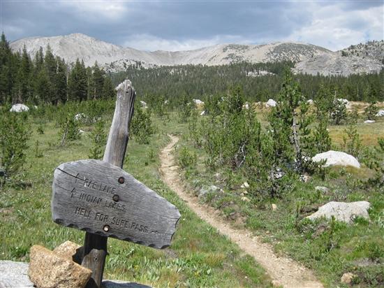
PART I – HELL FOR SURE
Situated far to the west of the main Sierra Crest, the LeConte Divide nonetheless features an array of rugged peaks over 12,000 feet and due to its location it is surprisingly remote. When you look at a map of the entire range of the Sierra Nevada and contemplate what might be the most remote location, the eye wanders to Goddard Canyon, the Ionian Basin and the Enchanted Gorge. The LeConte Divide forms the western boundary of that Bermuda Triangle of the Sierra, and perhaps at the center of it all is Martha Lake and Mount Goddard.
It was my intention to do an aesthetic traverse of that western boundary: climb up the western slope of the Sierra to Red Mountain Basin, where I would cross the Divide via Hell-for-Sure Pass into Goddard Canyon. Then follow that canyon to its headwaters at Martha Lake, and pass back over the Divide into Blackcap Basin via Valor Pass and return via the North Fork of the Kings River. As you can tell already, one thing the LeConte Divide region has in abundance is interesting place names: Devil's Punchbowl, Hell-for-Sure Lake and Pass, Disappointment Lake, Gunsight Pass, Ambition Lake, Valor Lake, the list goes on.

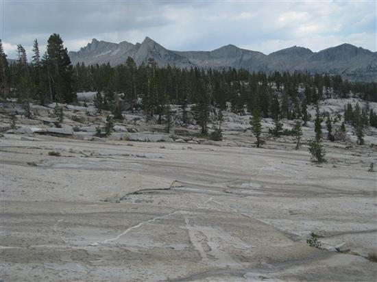
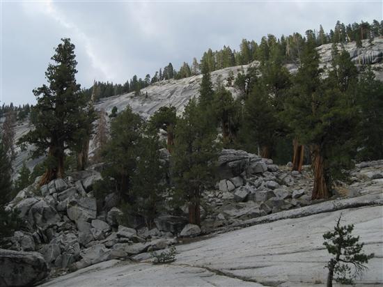
As with most hikes starting on the western slope, the majority of my first day was spent hiking through pleasant forests and flower-studded meadows, slowly gaining elevation and advancing towards treeline. The area east of Courtright Reservoir is known as Woodchuck Country, though for the life of me I have no idea why, as the closest thing to a woodchuck you'll find is a marmot at least ten miles to the east. After a few miles I passed the boundary marking the John Muir Wilderness.

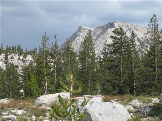
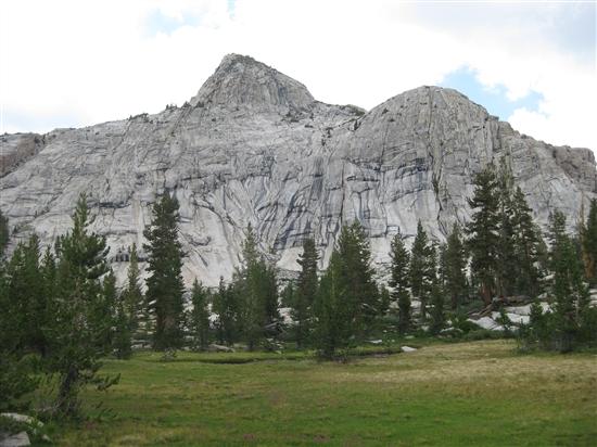
After a steady climb, I made my way into Red Mountain Basin. Nearing timberline, the trees receded and the mountains began to reveal themselves.
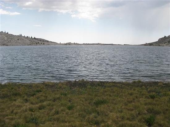
I hiked gentle granite slabs over a small rise, and suddenly in front of me was perhaps what is the most poorly named lake in the entire Sierra Nevada: Disappointment Lake. I can only imagine that it was named remotely by some poor employee of the California Geological Survey cooped up behind a desk pushing paper somewhere in Sacramento, or perhaps by an early explorer destined for Hell-for-Sure Pass who was having a particularly bad expedition. But the name could not be further from the truth. In front of me was a deep blue lake, ringed by granite slabs and a sandy beach lined with vibrant grass that would be right at home on a putting green. Towards the inlet, a cascading creek tumbled down a granite staircase until it cut a deep winding channel through the grass pouring into the lake. Towards the outlet, the granite ridge containing the water narrowed until it was only a foot or so above lake level, forming an infinity pool with an unobstructed view to the horizon.
Disappointment Lake.Though I had plans for another six or seven miles that day, I was so thoroughly entranced that I walked the full perimeter of the lake. I found a thick Sierra Juniper, perhaps six feet in diameter, that had suffered some unknown trauma many years ago from snow or wind or lightning. It had a 45 degree bend in its trunk at about head level, and its thick trunk and canopy formed a nearly impenetrable ceiling over a soft floor of pine duff. With gathering thunderheads, I was extremely tempted to call it a day here and camp under the ready-made shelter. But it was only four o'clock, and the lack of any fish in the lake provided enough of a reason to keep on ambling towards Hell-for-Sure Pass.
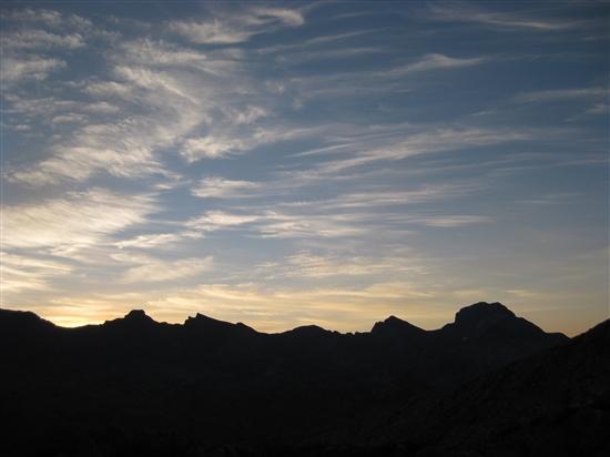
First view of Hell-for-Sure Pass. Doesn't look so bad.
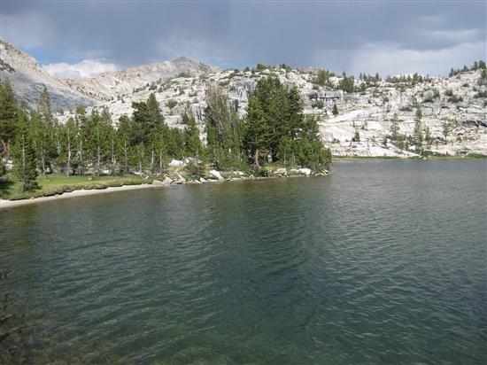
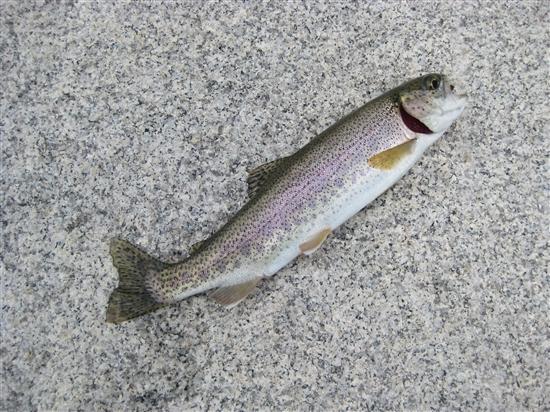
Hell-for-Sure Lake.Along the way I passed Hell-for-Sure Lake, which lacked the friendly trees but made up for it with a healthy fish population. I caught a brook trout on every cast, and I quickly had four fat ones about 8" long that I made into a nice trout soup with some lemon pepper. The sunset caught up with me partway up the switchbacks to the pass, and I threw down my bivy in a sheltered spot between a short cliff and a grizzled clump of whitebark pines.
Jul 21, 2013 at 8:28 pm #2008249PART II – AMBITION AND VALOR
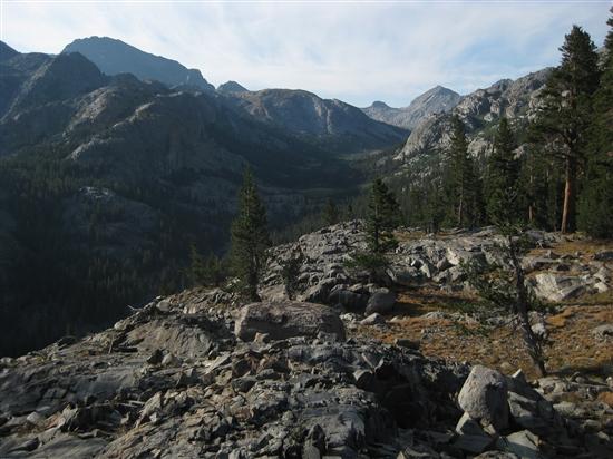
I awoke early the next morning, with ambitious plans to hike to the head of Goddard Canyon and climb Mount Goddard via its southwest ridge. As I made my way to the top of the pass, the early sunlight over the Goddard Divide was truly spectacular. I could even see so far as the Glacier Divide far to the east, and most spectacular of all, Mount Humphreys was visible on the horizon, perfectly framed in the notch formed by Snow Tongue Pass. As I descended the far side of the pass and rounded a ridge, I could see Seven Gables and Mount Gabb, fifteen straight-line miles to the north.
Goddard Divide at sunrise.The trail, which at this point had dwindled to a use path along the hillside, weaved its way through interlocking forested benches brimming with wildflowers as it descended towards the canyon floor. I passed a few Sierra tiger lilies, the first that I had seen this year. There were abundant mule's ear, forming a thick carpet of green and yellow in some places.
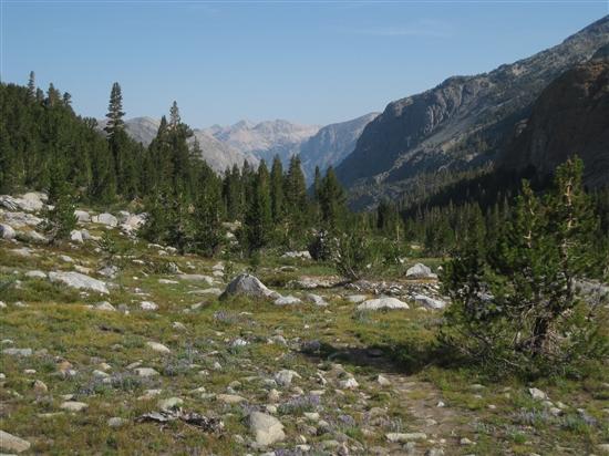
As the trail dropper lower, Goddard Canyon came into view, with the South Fork of the San Joaquin River thundering through a narrow slot at the bottom.
Upper Goddard Canyon.A surprisingly rugged descent dropped me into the bottom of the canyon. I stopped for breakfast, and a party of three Australians passed me on the trail. They too were headed for Mount Goddard, with a slightly more ambitious plan than mine: they would ascend the Goddard Divide to a notch on the east ridge just south of Wanda Lake, then climb the east ridge to the summit. My plan was to climb the southwest ridge, which is much more direct but is basically just 2500 feet of climbing loose scree. We discussed the weather, which was not looking good given that it was hot overnight and there were already clouds forming at 8AM. If I was going to make it up the mountain today, I had to do it quickly to beat the afternoon thunderstorms; being on the summit any later than noon would expose one to a small but significant chance of sudden death by electrocution.
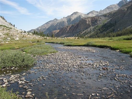
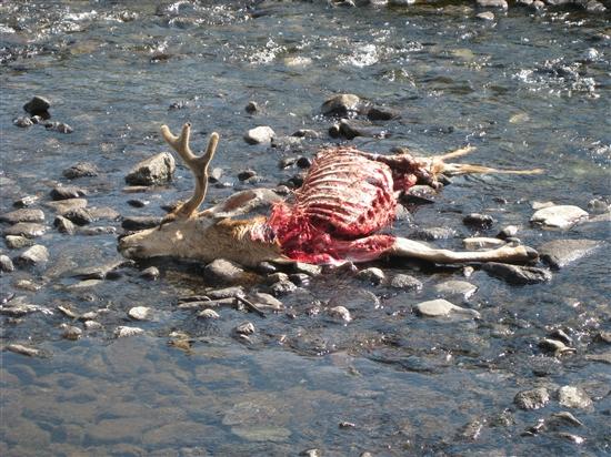
The floor of Goddard Canyon, with Mount Senger and Turret Peak in the distance.Any thoughts I had of rushing through Upper Goddard Canyon to attempt the mountain evaporated as soon as I entered the bottom of the canyon. Here was a truly special place, remote and beautiful. The canyon floor was carpeted with flowering lupine and lush green tundra, with pockets of krummholz and boulders interrupting the continuity of the meadows. Not since Bench Canyon in southern Yosemite had I seen such a place. Rushing through here would be akin to chugging a bottle of fine wine; no, I have rushed through enough beautiful places in my lifetime in the name of mileage goals and peaks to be bagged. I took out my fishing pole and slowly worked my way up towards Martha Lake, catching a number of beautiful golden trout in deep pools in the process. I startled a platinum blonde marmot, whose friends returned his chirping with a chorus of their own. Partway up canyon, I stumbled across a dead buck in the creek, which provided a compelling argument for water treatment even in remote places.
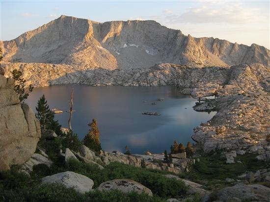
As I made my way over the final rise of glacier-scoured granite to Martha Lake, Mount Goddard loomed into existence to the north. I had seen it briefly from the pass earlier, but it truly dominated the skyline here. As I walked under it on my way around Martha Lake, it blotted out the northern hemisphere of my vision with its black, jagged mass. I tipped my hat to it and thought to myself, I'll see you again sometime soon.
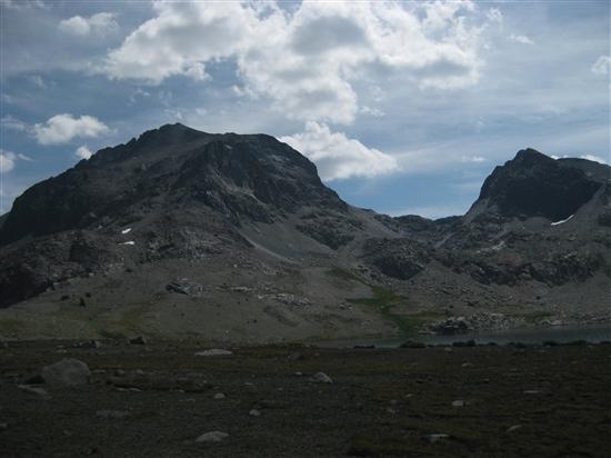
Mount Goddard towering above Martha Lake. The notch in the skyline leads to the start of the southwest ridge, and into Ionian Basin.My view drifted to the southwest, back towards the LeConte Divide which I now faced head-on. Due to the uplift of the North American plate that caused the formation of the Sierra Nevada, the entire range is tilted to the west. This is why I had to walk through forest for ten hours the day before to get to the crest, and is also why the east side of the LeConte Divide formed the sheer wall that I found myself underneath. As with many cross-country passes in the Sierra, at first view Valor Pass looked absurd; the same glacier that had formed the deep gouge filled in by Martha Lake had systematically scoured the wall of any weakness that I might use to pass through.
LeConte Divide, north of Martha Lake & Valor Pass.
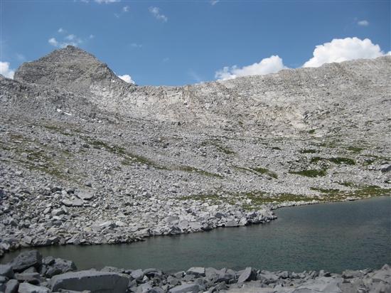
Valor Pass.It could be called a rite of passage for any Sierra adventurer to get sandbagged by Secor's "The High Sierra: Peaks, Passes and Trails". Up to this point, I had avoided that fate through the vast quantity of information that is available on the internet. But Valor Pass is kind of obscure, and I hadn't looked very hard since the topo map looked straightforward. I simpy relied on his description, written for the northbound traveller: "Class 2-3. Descend the northeast side of the pass by first going east and then north to Martha Lake." Scanning the skyline, I was hoping for something more in the vicinity of Class 4 if I got lucky. But you can almost never tell how steep something is until you are climbing up it, and after identifying a few vague ledges I started up.
Almost on top.I have enough experience that I should know better by now: it was nowhere near as bad as it looked once I started climbing. It did get steeper near the top, and I could not call the way I went class 2 with a straight face. At one point my three points of contact consisted of two feet stemmed out on opposing smooth granite walls, with my right hand hand-jammed in a crack in the back of the chimney. But there were never more than one or two moves at a time, most of which consisted of mantling up onto the next waist-high shelf or frictioning up a sticky granite slab, and there was basically zero exposure. Probably about class 3, though there's no guarantee that I went the easiest way. At any rate, I was at the top in short order, out of breath but otherwise un-sandbagged.
On the far side of the pass, the view forward was completely different: the gentle western slope greeted me with smooth granite slabs descending to Valor and Ambition Lakes.
Jul 21, 2013 at 8:28 pm #2008250PART III – HEADWATERS COUNTRY
At this point my decision to not climb Goddard left me way ahead of schedule, and a loud thunderclap to the north reinforced my decision. As I entered into the headwaters of the North Fork of the Kings River, the clouds that had been building all day began to sprinkle on me. In between showers I managed to get in about 30 minutes of fishing at Valor Lake, and caught a number of very eager rainbow trout, never having to cast more than a few times in between fish. The relaxed schedule meant I was free to take my time descending the canyon, exploring and fishing as I went.
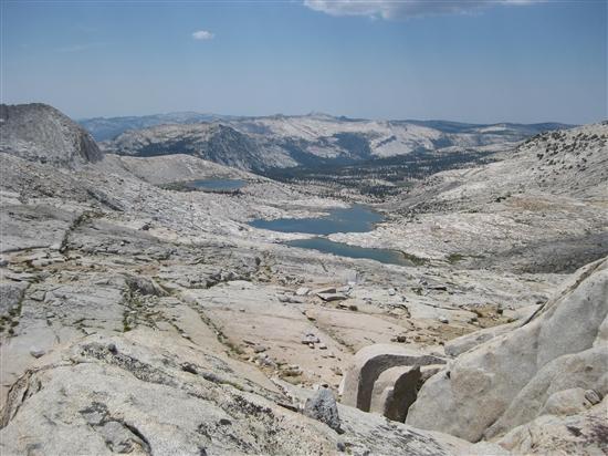
Valor Lake.All routefinding troubles were behind me now. I was in Blackcap Basin, and the most pleasant form of cross-country travel presented itself to me. Thousands of individual rivulets of water cascaded over granite slabs, leading towards the meadows below and ultimately to the North Fork of the Kings River. I had no particular concern for what direction I was going – as long as I went down, following the water, the river would eventually lead me home. This kind of travel is even easier than walking on a well-maintained trail. There's no particular need to follow any set path, or strictly follow any switchbacks; you simply move forward in whichever way seems most pleasing to you.
Eventually I had dropped far enough that the individual water courses converged together into the North Fork of the Kings River. A well-maintained path appeared at this point, and I followed it down through a lush forest. The thunderheads began a much more powerful display at this point, with intermittent heavy rain and many thunderclaps echoing through the canyon. The thick vegetation meant that the mosquitoes had returned, and I had the unique experience of hiking in a rainstorm with my headnet on. Eventually the canyon widened enough that the lodgepole forest returned and the bugs died down. I hiked until the sun set, and found a thick grove of lodgepoles that formed a thick canopy overhead. Despite the thorough soaking the forest had received, the ground underneath was bone dry – I threw my bivy down and went to sleep.
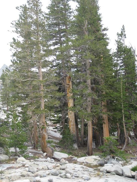
A stand of stately old Sierra junipers on the North Fork of the Kings.
Big Maxson Meadow.
More granite goodness on the NF Kings.The next morning, a chickoree's call from a nearby tree served as an alarm clock around sunrise and a brief 8 miles or so lead me the rest of the way back to my car and back home. As I was driving through the central valley, I passed over a wide concrete bridge with a sign proclaiming, "SAN JOAQUIN RIVER." In my mind, I traced that watercourse all the way back through the western slope, past Balloon Dome, through Florence Lake, past Piute Canyon and Evolution Valley, all the way up Goddard Canyon to Martha Lake, where I had been just a day before.
Jul 22, 2013 at 3:41 am #2008299Excellent TR. Drooling with envy.
Would love to see some pics of your bivy sites and setup and some more details on your gear and fishing setup, but just from personal curiosity.
Thanks for sharing.
Jul 22, 2013 at 12:42 pm #2008417Excellent report, Andrew. Looks like a great route from the west side.
Nice hat!
Jul 22, 2013 at 3:17 pm #2008466Great Report Andrew….I want to go there!
Jul 22, 2013 at 5:22 pm #2008504M G, you can see my approximate gear list in my profile… only differences are I didn't bring a puffy jacket, and I added back in Tenkara gear, a SPOT messenger, a compass and an altimeter.
Here's my first night's campsite…
And the second night's.
As usual the Tenkara rod was amazing for creek fishing, and did pretty well lake fishing too. The trick to Tenkara fishing on lakes here is to find a spot where a cliff plunges into the water and fish from the edge. That gives you access to deep water that ordinarily you would have to cast 30-40 feet out into the lake to find. You won't catch as many big fish this way as you would with a traditional fly rod, but you can do pretty well. The rainbow trout were so eager to strike that they tried to choke down my strike indicator floating on the surface almost as many times as they went after the bead head pheasant tail I was fishing just under the surface. Maybe next time I should try using a dry fly and dropper combo…
Jul 22, 2013 at 8:53 pm #2008575Inspirational! Thanks for sharing your well written trip report and pictures. Who needs to drive around to the east side when scale the Le Conte Divide.
Btw, I spent last weekend near Minaret Lake and since you told me about the chickadee all I hear is cheeseburger and think of Andrew. At least I can now name one bird call.
Jul 23, 2013 at 12:58 am #2008618This is beautiful! Thanks for posting the details. I feel more completely immersed in the surroundings when traveling solo, and the surroundings rarely get more beautiful than in the High Sierra.
Jul 23, 2013 at 7:30 am #2008693 AnonymousInactive
Fantastic report and photos. You have me thinking about a change of plans later in August.
Jul 23, 2013 at 9:10 am #2008724Awesome trip… jealous.
Gotta get a High Sierra solo trip in sometime soon.
Aug 4, 2013 at 9:07 pm #2012454Hi Andrew,
We missed each other by a week. Michelle and I just spend two weeks with our four girls in the same area. Goddard Canyon and Hell-For-Sure Pass were truly spectacular. We also explore the Red Rock Basin and went over Thompson Pass and did some cross country over Mosquito Pass down to Blaney Meadows. The Indian Lakes and Heather Lakes are worth a visit — and don't forget your Tenkara when you go there :)
Best Regards,
Manfred
-
AuthorPosts


- You must be logged in to reply to this topic.
Forum Posting
A Membership is required to post in the forums. Login or become a member to post in the member forums!
Our Community Posts are Moderated
Backpacking Light community posts are moderated and here to foster helpful and positive discussions about lightweight backpacking. Please be mindful of our values and boundaries and review our Community Guidelines prior to posting.
Get the Newsletter
Gear Research & Discovery Tools
- Browse our curated Gear Shop
- See the latest Gear Deals and Sales
- Our Recommendations
- Search for Gear on Sale with the Gear Finder
- Used Gear Swap
- Member Gear Reviews and BPL Gear Review Articles
- Browse by Gear Type or Brand.
